
An Enhanced Risk (Level 3 of 5) for scattered severe thunderstorms has been outlooked across the Ohio Valley today. Tornadoes, hail, and damaging winds possible. Farther west on the back side of the storm system driving the severe thunderstorms, strong winds and critical fire weather will affect the High Plains and parts of the Rockies through midweek, along with heavy snow in the high Rockies. Read More >
|
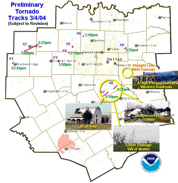
Preliminary Tornado Track Information From March 4, 2004
|
|
|
The National Weather Service office in Fort Worth surveyed the storm damage in Ellis and Kaufman counties. The results of the survey are below. In Ellis county...analysis of the damage and Doppler radar data Suggests two tornadoes occurred in the southern part of the county. The first tornado touched down approximately 3 miles south of Italy. A mobile home was un_roofed southeast of Italy and numerous barns and Outbuildings were damaged along the path. Several house roofs lost Shingles and sheathing. Southwest of the Avalon community...a High_tension tower was bent down. The tornado dissipated just Southeast of Avalon. Based on the damage to the tower...this tornado Is rated F1 on the Fujita scale. The second tornado developed approximately 1 mile south of the Bardwell community. The tornado damaged trees and storage buildings South and southeast of bardwell. As the tornado moved into Ennis...a Mobile home was un_roofed and several semi trailers were overturned In the southern part of the city. The tornado removed most of the Roof of a warehouse/office building along interstate 45 and Overturned another semi tractor trailer on the interstate. The Tornado dissipated just southeast of Ennis. Based on the damage to The warehouse building...this tornado is also rated F1 on the Fujita Scale. In Kaufman county...a powerful downburst moved from 3 miles west of Kaufman to the southeastern edge of Terrell. The downburst destroyed A storage building and partially un_roofed a home west of Kaufman.
|
 |
|
Several homes in the same area received lesser amounts of roof damage. In the post oak bend community...several trees and a mobile home were heavily damaged...one home was partially un_roofed...and several structures suffered minor roof damage. Several trees were Broken and a home received roof damage. Based on the damage west of Kaufman and in post oak bend...maximum wind speeds were in the 70_75 mph range. Damage in eastern Collin county...which extended from near lake Lavon to several miles northeast of Farmersville. The first damage was found on the east side of Lavon lake...about 2 and 1/2 miles west_southwest of Copeville. Damage extended to the north_northeast into Farmersville. The last damage was found several miles northeast of the town. The overall damage track width varied from 1/4 to 1/2 of a mile in width. Along the first 3 miles of the track...there were a number of Indications of convergence in the debris pattern (of items that were Damaged or destroyed) including trees...mobile homes ...homes...road Signs...and power poles. Moreover...several eye witness accounts of "swirling debris" were received in this area. Our conclusions Currently are that a tornado with a track length of about 3 miles and a width of 100 to 200 yards formed on the east side of the Lake...and dissipated about 2 miles north_northwest of Copeville. In addition...a broader area of downburst winds accompanied the tornado To its immediate east...then extended into the Farmersville area ...beyond where the tornado dissipated. This broader downburst area probably resulted in the extensive Damage to a school complex on the north side of Farmersville...Including severe damage to a school gym...athletic field...and Several cinder block buildings. No evidence was found of tornadic Rotation in Farmersville. However...several eyewitnesses reported Seeing rotation during the wind event. We are awaiting further Information ...or photography...that might indicate tornadic winds Were involved with damage in Farmersville. Doppler radar did indicate weak...elevated rotation with this thunderstorm...closely linked to the damage path.
|
|


 Follow us on YouTube