


 Hazardous Weather Outlook - Day 2


- WWA
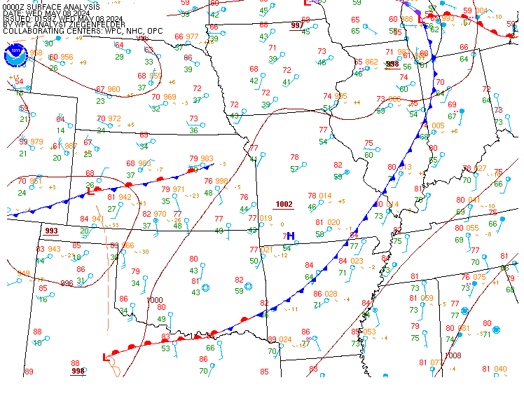
map - Local
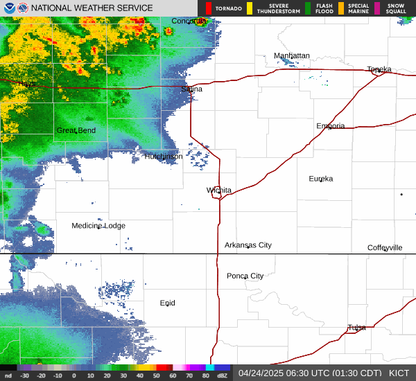
radar - Storm
Reports - obs
display - Image
swap - Local time
- UTC
Current watches, warnings, and advisories
|
|
Local Storm Reports


Weather Briefing Page - Winter weather | |
|
Current watches, warnings, and advisories
Local Storm Reports
|
|||||||||||
Web page updates automatically every 5 minutes. This page will update itself automatically every 5 minutes, or you can force a refresh at any time by clicking on the gray button in the upper right of the page. Using the browser's refresh button may not work due to caching issues.
Quick access to the multimedia hazardous weather briefing and the daily weather story. Both the multimedia briefing and the weather story can be viewed right on this page! Clicking the appropriate icon will open a box just like this help page. To return to the briefing page, click the "X" in the upper right corner of the dialog box (not the browser).
Display small tabs by hovering over the name. Mouse over the name of a tab (for example, "Day 1 QPF") to view its contents.
Display large tabs by clicking on the name. Click the name of a large tab (for example, "WWA map") to view its contents.
Enlarge an image in the small tabs. Click on an image in the small tabs to make it appear in the larger "image swap" tab.
Scrolling tabs in the center of the screen. Continuous scrolling of the large tabs provides a quick way to keep up with what's going on across parts of Missouri and Illinois.
Temporarily stop the tabs by hovering with the mouse. To stop the large tabs from scrolling, use the mouse to hover over any part of the tabbed area. Scrolling will resume a few seconds after the mouse leaves the tabbed area.
Use the play/stop icons to start/stop tab scrolling. Please note that the tabs will start to scroll again when the page automatically updates every 5 minutes.
GIS display for local storm reports. Local Storm Reports (LSRs) are displayed graphically in Google Maps. Zoom in/out with the mouse wheel or the slider scale on the map.
Quick access to certain text products. The HWO, Zone Forecast Product (ZFP), and most recent LSR are displayed in tabs. Mouse over the 3-letter identifier (HWO, ZFP, or LSR) to view the text product.
When I first load the web page, it looks strange for a few seconds. What's going on? It's called a "flash of unstyled content", or FOUC. It is completely harmless. It's just an artifact of the computer code that makes the web page work.
The graphics look odd in the "image swap" tab. Lines are jagged or broken, and it's hard to read the text in the lower left corner. What's going on? This is a problem with how Internet Explorer handles image rendering. The graphics look fine in Mozilla Firefox.
The GIS display is broken. Part of the display is grayed out and the controls don't work very well. What happened, and how do I fix it? Sometimes there is a display conflict between the GIS display and the other tabs. To fix it, refresh the page by using the gray refresh button on the upper right side of the web page, or by placing your cursor in the address bar of the web browser and pressing enter. Using your brower's refresh button may not work.
The GIS display doesn't show any storm reports, but several LSRs have been sent out. What's going on? The GIS display uses a file provided by the WDSSII group at the National Severe Storms Laboratory. This file is provided on a non-operational basis and may experience temporary data outages. This is why the GIS display might be empty even if storm reports have been sent out.
I'm not an emergency manager. Can I still use this page? Absolutely! Although this page was developed to meet the needs of emergency managers in our county warning area, it is available for everyone to use.
Who should I contact to provide feedback on this web page? Please send your feedback in an email to the ICT webmaster ( )