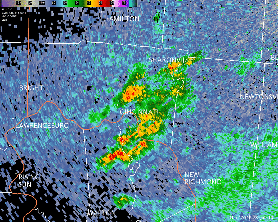
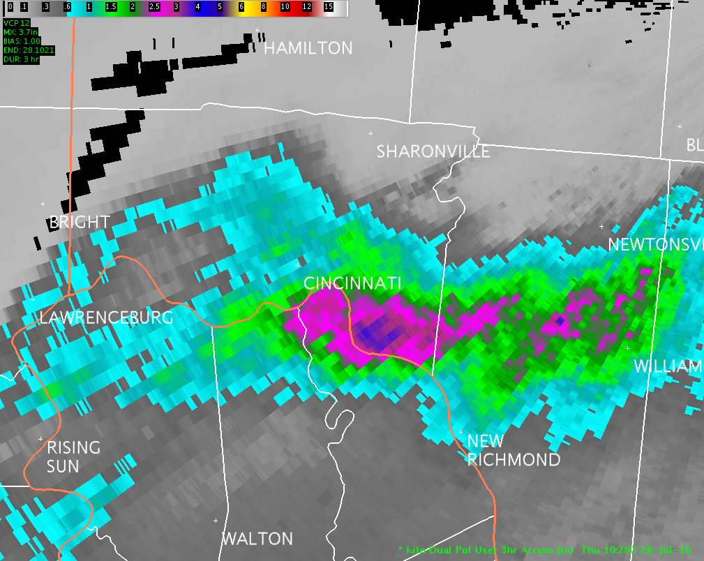
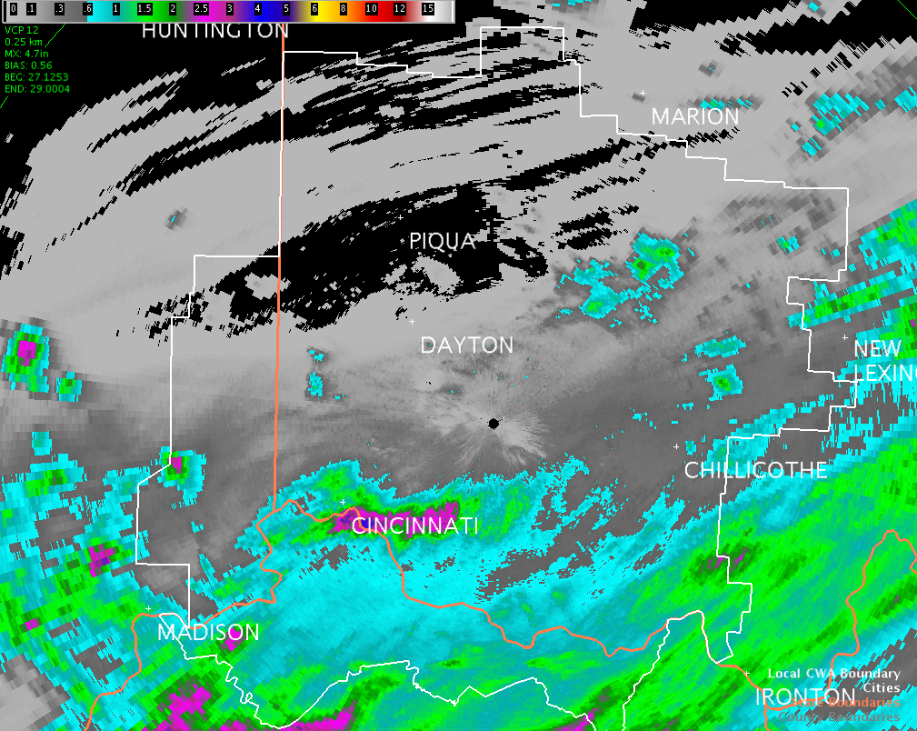
Public Information Statement National Weather Service Wilmington OH 336 PM EDT Thu Jul 28 2016 ...24 hour Rainfall Reports over 1/2 inch... Location Amount Time/Date Lat/Lon ...Indiana... ...Franklin County... 1 SSW Brookville 0.53 in 0245 PM 07/28 39.41N/85.01W ...Ohio County... 3 SSE Aurora 1.26 in 0800 AM 07/28 39.02N/84.89W ...Switzerland County... 2 WSW Vevay 0.76 in 0301 PM 07/28 38.73N/85.09W ...Kentucky... ...Boone County... Woolper Creek Near Burlingto 1.79 in 0245 PM 07/28 39.03N/84.80W Elijahs Creek Near Hebron 1.50 in 0300 PM 07/28 39.08N/84.69W Cincinnati/n Ky Intl Apt 1.34 in 0752 AM 07/28 39.05N/84.67W Burlington 1.33 in 0600 AM 07/28 39.02N/84.73W Burlington 1.29 in 0310 PM 07/28 39.04N/84.72W 5 ESE Rising Sun 1.18 in 0310 PM 07/28 38.91N/84.77W Oakbrook 1.05 in 0309 PM 07/28 38.99N/84.69W 3 ENE Rising Sun 0.83 in 0240 PM 07/28 38.97N/84.79W Oakbrook 0.68 in 0306 PM 07/28 39.00N/84.69W Union 0.58 in 0308 PM 07/28 38.95N/84.66W Gunpowder Creek Near Union 0.57 in 0800 AM 07/28 38.99N/84.72W ...Bracken County... 1 NE Brooksville 1.28 in 0308 PM 07/28 38.70N/84.05W 4 NNE Mount Olivet 1.21 in 0245 PM 07/28 38.59N/84.02W 2 WSW Augusta 0.57 in 0700 AM 07/28 38.75N/84.05W ...Campbell County... Taylor Creek At Riveria Driv 4.79 in 0230 PM 07/28 39.10N/84.48W Newport 3.53 in 0307 PM 07/28 39.09N/84.50W Three Mile Creek At Highway 3.21 in 0230 PM 07/28 39.05N/84.49W Crestview 1.37 in 0300 PM 07/28 39.02N/84.41W Twelvemile Creek Near Alexan 0.82 in 0245 PM 07/28 38.95N/84.34W 1 WNW California 0.73 in 0310 PM 07/28 38.93N/84.29W Fourmile Creek Near Alexandr 0.71 in 0200 PM 07/28 38.98N/84.36W 2 SSE Crestview 0.70 in 0307 PM 07/28 38.99N/84.40W ...Gallatin County... 2 NNE Sanders 2.55 in 0300 PM 07/28 38.68N/84.94W 2 NW Glencoe 0.89 in 0700 AM 07/28 38.74N/84.85W ...Grant County... 2 N Dry Ridge 1.48 in 0750 AM 07/28 38.72N/84.59W Crittenden 0.80 in 0257 PM 07/28 38.77N/84.60W ...Kenton County... Park Hills 3.47 in 0700 AM 07/28 39.08N/84.52W 1 NE Kenton Vale 3.24 in 0730 AM 07/28 39.07N/84.50W Pleasant Run Creek At Oak St 2.88 in 0215 PM 07/28 39.09N/84.56W Park Hills 2.84 in 0700 AM 07/28 39.06N/84.55W Fort Wright 2.75 in 0258 PM 07/28 39.06N/84.54W Dry Creek At Sewage Plant 2.46 in 0230 PM 07/28 39.06N/84.62W Visalia 0.71 in 0230 PM 07/28 38.92N/84.45W Cruises Creek Near Piner 0.70 in 0245 PM 07/28 38.84N/84.53W Banklick Creek Near Edgewood 0.58 in 0300 PM 07/28 38.98N/84.54W ...Owen County... 5 SSE Glencoe 1.06 in 0302 PM 07/28 38.64N/84.78W ...Pendleton County... Licking River At Mckinneysbu 1.51 in 0245 PM 07/28 38.60N/84.27W Hayes 1.01 in 0215 PM 07/28 38.66N/84.35W ...Ohio... ...Brown County... 1 NNW Fayetteville 1.22 in 0256 PM 07/28 39.20N/83.94W 3 N Aberdeen 1.20 in 0303 PM 07/28 38.71N/83.77W 3 SE Mount Orab 0.94 in 0305 PM 07/28 38.99N/83.88W 1 W Mount Orab 0.77 in 0310 PM 07/28 39.03N/83.95W Georgetown 0.73 in 0307 PM 07/28 38.86N/83.90W ...Butler County... 3 E Beckett Ridge 0.60 in 0301 PM 07/28 39.35N/84.38W ...Clermont County... Clermont County Airport 2.92 in 0754 AM 07/28 39.08N/84.21W Owensville 2.03 in 0600 AM 07/28 39.11N/84.14W Mount Repose 0.77 in 0255 PM 07/28 39.19N/84.22W 2 SSE Pleasant Plain 0.55 in 0310 PM 07/28 39.24N/84.10W 3 WSW Bethel 0.54 in 0900 AM 07/28 38.93N/84.14W ...Fayette County... Greenfield 0.55 in 0300 PM 07/28 39.38N/83.38W ...Franklin County... 3 WSW Dublin 0.75 in 0305 PM 07/28 40.09N/83.18W ...Hamilton County... Cherry Grove 4.00 in 0259 PM 07/28 39.09N/84.33W 1 W Bellevue 3.94 in 0259 PM 07/28 39.10N/84.50W Cincinnati Lunken Field 3.41 in 0753 AM 07/28 39.10N/84.42W Bridgetown North 3.36 in 1135 AM 07/28 39.15N/84.63W 1 WSW Fairfax 2.69 in 0308 PM 07/28 39.13N/84.42W Madeira 2.51 in 0308 PM 07/28 39.18N/84.37W Mount Healthy 2.21 in 0310 PM 07/28 39.24N/84.56W North College Hill 2.19 in 0306 PM 07/28 39.21N/84.55W 1 SSW North College Hill 1.93 in 0304 PM 07/28 39.20N/84.56W 1 WNW Saint Bernard 1.72 in 0300 PM 07/28 39.18N/84.53W White Oak West 1.60 in 0309 PM 07/28 39.20N/84.61W Madeira 1.50 in 0310 PM 07/28 39.19N/84.37W Kenwood 1.46 in 0309 PM 07/28 39.20N/84.36W 1 WNW Wyoming 1.41 in 0700 AM 07/28 39.24N/84.50W 1 SSE Covedale 1.21 in 0301 PM 07/28 39.10N/84.63W Madeira 1.13 in 0303 PM 07/28 39.18N/84.36W White Oak West 0.98 in 0600 AM 07/28 39.20N/84.61W Dillonvale 0.77 in 0247 PM 07/28 39.22N/84.41W 1 NNW Montgomery 0.76 in 0302 PM 07/28 39.27N/84.35W Miamitown 0.73 in 0800 AM 07/28 39.20N/84.70W Bridgetown North 0.61 in 0305 PM 07/28 39.16N/84.65W 1 WNW Mack North 0.59 in 0304 PM 07/28 39.18N/84.70W Sharonville 0.54 in 0307 PM 07/28 39.27N/84.41W Pleasant Run Farm 0.54 in 0305 PM 07/28 39.30N/84.53W Addyston 0.54 in 0305 PM 07/28 39.14N/84.70W ...Highland County... 2 SSE Saint Martin 1.53 in 0730 AM 07/28 39.18N/83.86W Hillsboro 1.29 in 0310 PM 07/28 39.21N/83.60W Hillsboro 1.15 in 0245 PM 07/28 39.20N/83.61W Centerfield 0.50 in 0245 PM 07/28 39.33N/83.48W ...Pike County... 1 SSE Waverly 0.51 in 0800 AM 07/28 39.11N/82.98W ...Scioto County... 9 NE Vanceburg 1.07 in 0224 PM 07/28 38.70N/83.20W Sciotoville 1.00 in 0100 PM 07/28 38.76N/82.89W Observations are collected from a variety of sources with varying equipment and exposures. Not all data listed are considered official. $$ NWS Wilmington OH IRIS System |
 |
 |
 |

