Louisville, KY
Weather Forecast Office
This was a warm spring (March - May) with average temperatures a few degrees above normal and almost no snow. Precipitation varied greatly across the region, with some locations getting doused while others remained relatively dry. Severe weather was more active this spring than in the previous few springs. There were 16 tornadoes in southern Indiana and central Kentucky this spring, which is the most we have had in a spring season since 2011. All but two of the tornadoes were rated at EF-1. The two stronger tornadoes, both EF-2, occurred during the most widespread outbreak of the season, on the first day of March. The most significant was the EF-2 that struck Ireland, Indiana in DuBois County a few minutes after midnight that day.
| Average Temperature | Departure from Normal | Precipitation | Departure from Normal | Snowfall | Departure from Normal | |
| Bowling Green | 60.8° | +3.3 | 13.72" | -0.64" | T | -1.3" |
| Frankfort | 58.5° | +3.8 | 14.38" | +1.46" | ||
| Lexington | 58.6° | +3.6 | 10.76" | -2.17" | T | -1.7" |
| Louisville Bowman | 60.3° | +3.5 | 13.54" |
+0.18" |
||
| Louisville International | 61.2° | +3.6 | 12.89" | -0.56" | T | -1.5" |
2nd warmest spring on record at Louisville
4th warmest spring on record at Lexington
9th warmest spring on record at Frankfort
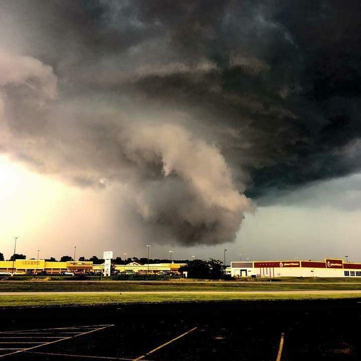
Tornadic storm bearing down on Madison, Indiana, on May 20. Photo from Madison 5 Fire Department Facebook page.
Current Hazards
Hazardous Weather Outlook
Storm Prediction Center
Submit a Storm Report
Advisory/Warning Criteria
Radar
Fort Knox
Evansville
Fort Campbell
Nashville
Jackson
Wilmington
Latest Forecasts
El Nino and La Nina
Climate Prediction
Central U.S. Weather Stories
1-Stop Winter Forecast
Aviation
Spot Request
Air Quality
Fire Weather
Recreation Forecasts
1-Stop Drought
Event Ready
1-Stop Severe Forecast
Past Weather
Climate Graphs
1-Stop Climate
CoCoRaHS
Local Climate Pages
Tornado History
Past Derby/Oaks/Thunder Weather
Football Weather
Local Information
About the NWS
Forecast Discussion
Items of Interest
Spotter Training
Regional Weather Map
Decision Support Page
Text Products
Science and Technology
Outreach
LMK Warning Area
About Our Office
Station History
Hazardous Weather Outlook
Local Climate Page
Tornado Machine Plans
Weather Enterprise Resources
US Dept of Commerce
National Oceanic and Atmospheric Administration
National Weather Service
Louisville, KY
6201 Theiler Lane
Louisville, KY 40229-1476
502-969-8842
Comments? Questions? Please Contact Us.


 Weather Story
 Weather Map
 Local Radar