| A Review of Weather in 2001 |
The first year of the new millenium was for the most part more benign than its predecessor 2000, a year that was marked by many weather extremes. When the year 2001 began, we were in the midst of one of those extremes, the brutally cold early winter of 2000-2001. Temperatures moderated considerably in February and then leveled off, with March actually averaging a bit cooler than February this year. March also brought a tornado outbreak to parts of the Florida Panhandle and Southwest Georgia on the 15th. Fortunately, this one was not as deadly as the one that struck the area on Valentines Day 2000. The summer of 2001 was not as hot as recent summers. In fact the mercury never reached the century mark. The heat was tempered by frequent rains. The nearly four-year-long drought came to an end during the summer, due in large part to deluges received from two tropical systems. The remnants of Tropical Storm Allison in June brought over 10 inches of rain to Tallahassee, with similar totals measured when Tropical Storm Barry came ashore in the Panhandle in August. The autumn months continued the trend set during the spring. A cooler than normal early fall and warmer than normal late fall resulted in a very gradual temperature transition through the season. Following are a few of the weather highlights that occurred in the NWS Tallahassee County Warning & Forecast Area in 2001.
Tornadoes of 15 March 2001
Four tornadoes touched down in the NWS Tallahassee County Warning Area during the early morning hours of Thursday, March 15, 2001. The first tornado touched down at 3:30 am CST near the Eastern Florida Panhandle town of Wausau, FL, in Washington County and was on the ground for 18 minutes. This tornado was rated an F2 on the Fujita scale as it crossed the eastern part of the county, weakening to F1 strength as it crossed into the Round Lake area of southwestern Jackson County. Less than two hours later, another F2 tornado touched down near the Decatur-Grady County line in Southwest Georgia. The twister developed around 6:10 am EST near Feuell Rd., three miles south of Climax, GA, and was on the ground for about seven minutes, passing near Whigham, GA, at 6:15 am. A few minutes later, another tornado touched down at 5:30 am CST in the Eastern Florida Panhandle, north of Wewahitchka between Chipola Park and Kinard, in Calhoun County. The tornado was just F0 strength as it touched down and was only on the ground for about five minutes, briefly strengthening to F2. Finally, a fourth tornado touched down northeast of Pavo, GA, along the Thomas-Brooks County line in Southwest Georgia at 8:05 am EST. This tornado was rated F1 and was on the ground for about 15 minutes. Considering the early-morning hour of these events, it is fortunate that the tornadoes resulted in only one fatality. Unfortunately, some 37 people were injured in the first two tornadoes, which damaged or destroyed dozens of homes. Damage paths of the four tornadoes are plotted in Figure 1. Additional details can be found in our web page about the event located at https://www.srh.noaa.gov/tae/event-20010315.
While this was certainly the most significant severe weather episode of the year, other days during which severe weather occurred in the county warning area include: January 19; March 3, 12, 20 and 29; May 12, 19, 27 and 28; June 4, 5, 11-12, 14, 18, 19, 21, 22, 27 and 28; July 3, 10 and 11; August 6; October 13-14; and November 25. During the last event, an isolated tornado formed in Southeast Alabama and happened to go right through downtown Daleville in southern Dale County, just south of Fort Rucker, AL. In addition to several mobile homes being destroyed, a bank, church, supermarket, Wendy's restaurant, and several other business and automobiles were severely damaged. The roof at the Flight Line lounge collapsed with 125 people inside. Twenty five people were injured, 13 hospitalized, and three treated for serious injuries. Amazingly, there were no fatalities.
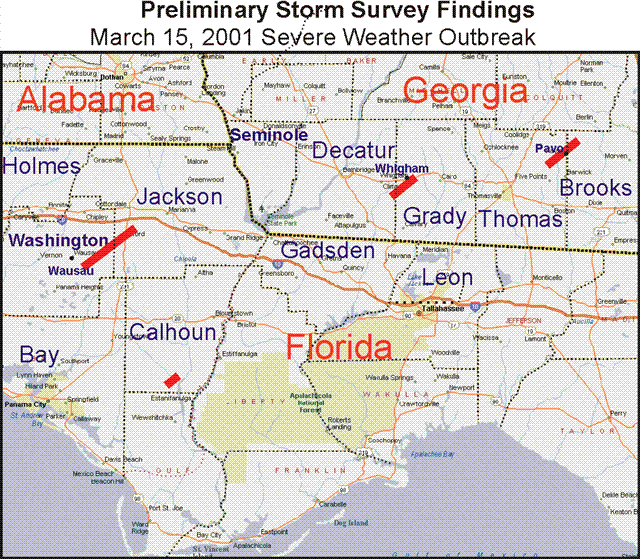
Figure 1. Damage paths and strengths (on the Fujita scale) of the four tornadoes that touched down on March 15.
As can be seen in Figure 2, the year started out on a very cold note. January 2001 had an average temperature of just 47.6 degrees, the coldest month in Tallahassee since December 1989. Freezes occurred on 10 of the first 11 days of the year, and most of these were hard freezes. In total, freezing temperatures occurred on 16 days in January with the coldest temperature of the calendar year occurring on the tenth when the mercury reached 19 degrees. Although the total number of freezes for the 2000-2001 winter season averaged only slightly above normal, the city set a record for the number of hard freezes that occurred. The temperature dipped to 25 degrees or lower 19 times during the season and a dozen times in January alone. Despite the cold, no daily record lows were established during the month. During a brief mid-month warm-up, the monthly maximum temperature of 79 degrees tied the record for the date on January 19.
In stark contrast, February was unusually warm and dry. The temperature average 6.6 degrees above normal for the month and there were only two mornings that had light freezes. In fact, there were no freezes from February 8 through March 7 inclusive. March brought much needed rainfall. Nearly nine inches of rain fell in Tallahassee that month. The frequent rains and associated extensive cloudiness helped keep temperatures down and March actually averaged 0.2 degrees cooler than February. There were no daily record highs or lows set in either month.
April was somewhat unusual in that it was warmer in the first half of the month than in the latter half. Temperatures remained below 90 during the month with a record low of 33 degrees established on the 19th. Summer temperatures were milder than in recent summers. The mercury reached 90 for the first time on May 6 and the last time on September 21. The hottest temperature of the year was only 96 degrees. Cold frontal passages occurred throughout the summer, including July. This allowed intrusions of somewhat cooler and drier air to penetrate south to the Gulf, providing pleasant respites from the unrelenting heat and humidity of a typical summer. No record high temperatures were established during the warm season, upsetting the trend of recent years. Daily low temperatures were recorded several times including 52 on May 24; 62 on June 25; 62 on August 22; 52 on September 17; 56 on September 18, and 47 on September 27.
The early season cool spells continued into October with the mercury dropping to 36 degrees on three days late in the month. The high temperature on October 28 was only 61 resulting in an average temperature for the day of just 49 degrees. A couple of light freezes occurred across the northern tier of our county warning and forecast area late in the month, with a morning low of 32 degrees in Dothan, AL, on October 28, and again in Albany, GA, on October 30. In Tallahassee, temperatures averaged nearly three degrees cooler than normal in September and nearly two degrees below normal in October.
An abrupt change to milder than normal conditions set in during November and continued well into December. Only one day in November failed to reach 70 degrees in Tallahassee. No freezes were recorded in northern Florida with just one freeze recorded north of the area, from Dothan to Albany, on November 21. In December, temperatures reached 80 degrees or above three times in the first half of the month. The first freeze of the season in Tallahassee was not recorded until the first day of winter, December 21. The normal date for the first freeze is November 6. October 28 remained the coldest day of the season until Christmas Day, when daytime temperatures peaked at only 47 degrees. The first hard freeze of the season occurred on the morning of December 27.
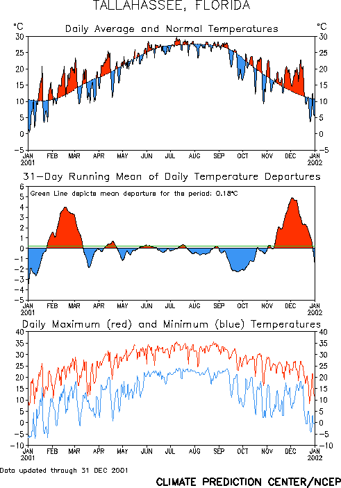
Figure 2. Temperatures in Tallahassee during the year 2001.
Drought Eases
The local drought that began in the spring of 1998 continued into the year 2001. As can be seen in Figure 3, except during the month of March, the rainfall deficit grew steadily through May. Tropical rains associated with the remnants of Tropical Storm Allison ended the annual deficit all at once and Tropical Storm Barry's rains put the area well into the surplus range in early August. However, the autumn months averaged drier than normal and by year's end that surplus had vanished. The annual rainfall total in Tallahassee was 65.71 inches which was 2.20 inches below the 1961-1990 normals.
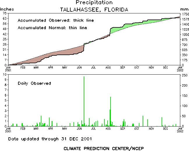
Figure 3. Rainfall in Tallahassee during the year 2001.
Mallory Swamp Fire
Before tropical rains could bring any drought or fire danger relief, a massive wildfire known as the Mallory Swamp Fire, was ignited by lightning on May 13. The fire was bounded by County Roads 349 and 51 in Lafayette County, and County Road 351 and U.S. Highway 27 in Dixie County. This fire burned 57,200 acres, according to the Florida Division of Forestry. Numerous homes on County Roads 349 and 351 were threatened and their residents evacuated, but none were damaged. Considerable haze and smoke from the blaze covered much of Interstate 10 from Tallahassee to Jacksonville. The fire burned for 25 days and was not put out until June 7.
Tropical Storm Allison
Although Allison was only at tropical storm strength for less than a day, it became the costliest tropical storm in U.S. history. The main culprit was flooding rains. Tallahassee's all-time 24-hour rainfall record was broken when 10.13 inches fell from June 11 into the morning of June 12. This eclipsed the old record of 9.47 inches set back in 1969. Federal disaster aid was declared for Leon County where nearly 600 residences, mobile homes, apartments and businesses were damaged or destroyed by floodwaters. There were numerous reports of people stranded in their vehicles on flooded streets and intersections in Tallahassee and surrounding areas. Several people were rescued from their flooded homes and apartments. Unfortunately, the flash flooding that resulted from the storm claimed one life when a vehicle was swept into a storm drain near Brevard and Dewey Streets in Tallahassee. His body was later discovered several miles downstream in a ditch near Lake Bradford Road and Gamble Street. His passenger narrowly escaped and was rescued. Numerous streets were damaged or strewn with debris. In the Eastern Florida Panhandle, flooding rains washed out a few roads in Panama City, while saturated grounds accounted for downed trees and power lines in Bay and Walton Counties.
A waterspout was sighted over Apalachicola Bay moving northeast toward Apalachicola and East Bay during the afternoon hours. It passed over the John Gorrie Memorial Bridge between Apalachicola and EaRTPoint, then dissipated near Magnolia Bluff. In Madison County, an F1 tornado touched down near Lake Logan Road, just northwest of Greenville. The tornado destroyed three double wide trailers, flipped over several vehicles, and downed numerous trees and power lines. One person sustained minor injuries from flying debris. Additional information on Tropical Storm Allison can be found here.
Tropical Storm Barry
Tropical Storm Barry made landfall near Destin, FL, during the early morning hours of August 6. Although there was some minor wind damage associated with the storm in the Panhandle, the main impact was once again the flooding rains. Officially, nearly nine inches of rain fell in Tallahassee. The highest unofficial rainfall total was 11 inches reported by a TV station in Panama City. Five- to ten-inch rainfall totals were common across the Eastern Panhandle and Western Big Bend. River flooding was not a big concern with only one river, the St. Mark's, briefly reaching flood stage. However, flooding impacted portions of southern Leon and northern Wakulla Counties for weeks after the storm, as drainage through the Munson Slough raised ground water levels in these areas. Fortunately, there were no tornado touchdowns associated with the landfall of Barry. Additional information on Tropical Storm Barry can be found here.
A review of local weather in 2000 is also available.
National Weather in 2001
An article summarizing last year's weather across the nation has been published by NOAA. A more detailed summary has been posted by NCDC. Also included in this site is a collection of significant weather events that occurred nationally last year.


 Follow us on YouTube