| Rainfall Summary: September 10-18, 2013 | ||||||||||||||||||||||||||||||||
|
The table below is a comprehensive list of the more significant precipitation reports that were received for the 9-day event period.
|
||||||||||||||||||||||||||||||||
| Impact Summary | ||||||||||||||||||||||||||||||||

|
||||||||||||||||||||||||||||||||
|
Hydrologic Summary
|
||||||||||||||||||||||||||||||||
|
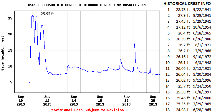
The Rio Hondo at Diamond-A Ranch crested at 25.95 feet (29,500 cfs) at 930am MDT September 11, 2013. This is now the 14th highest crest observed at this location and compares to a previous crest of 26.02 feet on September 12, 1996 and 25.7 feet on September 24, 1950. The record crest is 28.78 feet set back on September 22, 1941. Significant flooding was observed along the Rio Hondo from this location east all the way to Roswell. Water rescues took place along the US 70/285 bypass in Roswell where the Rio Hondo flows through the area. Action stage is 25 feet, minor flood stage 26 feet, moderate flood stage 27 feet, and major flood stage 28 feet.
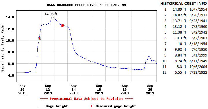
The Pecos River at Acme crested at 14.05 feet (~27,095 cfs) at 815pm MDT September 12, 2013. This crest is the 3rd highest on record for this location and compares to a previous crest of 14.82 feet on May 28, 1937 and 13.71 feet on September 23, 1941. The record crest is 14.89 feet set back on October 7, 1954. Flooding was observed along the Pecos River between Acme and Lake Arthur. Roads were closed in the area due to high water, some homes were flooded, and large areas of farmland were inundated. Action stage is 12 feet , minor flood stage 13 feet, moderate stage 14.5 feet, and major stage 16 feet.
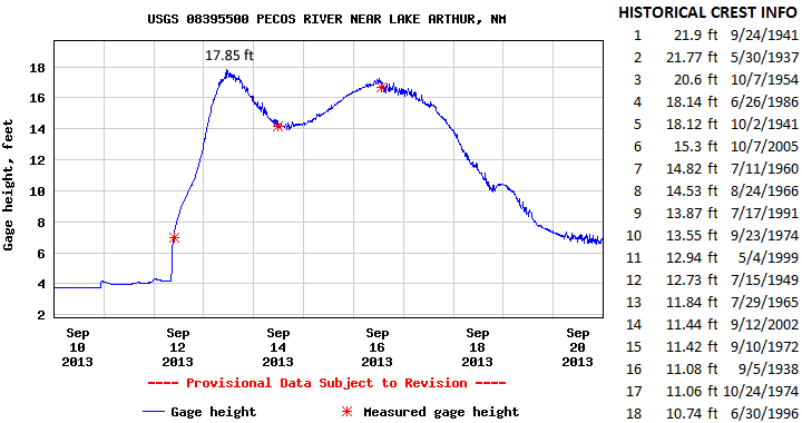
The Pecos River at Lake Arthur crested at 17.85 feet (5,690 cfs) at 1115am MDT September 13, 2013. This crest is now the 6th highest on record for this location and compares to a previous crest of 18.12 feet on October 2, 1941 and 18.14 feet on June 26, 1986. The record crest is 21.9 feet set back on September 24, 1941. Flooding was observed along the Pecos River between Acme and Lake Arthur. Roads were closed in the area due to high water, some homes were flooded, and large areas of farmland were inundated. Action stage is 17.5 feet and minor flood stage 20 feet. There has been no determination of moderate and major flood stages.
|
||||||||||||||||||||||||||||||||
|
Photos
|
||||||||||||||||||||||||||||||||
|
|
||||||||||||||||||||||||||||||||
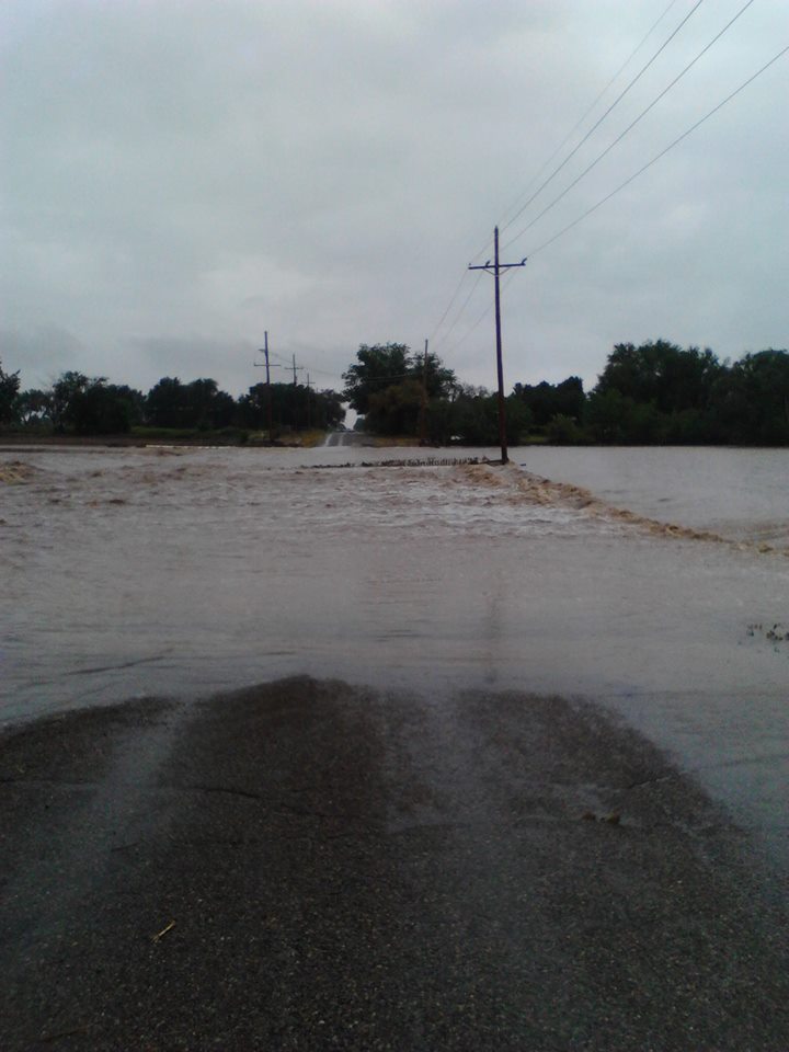
| Photo of flooded roadway near Roswell, NM. Image by Amy Cook. | ||||||||||||||||||||||||||||||||