| Rainfall Summary: September 10-18, 2013 | |||||||||||||||||||||||||||||||||
|
The table below is a comprehensive list of the more significant precipitation reports that were received for the 9-day event period.
|
|||||||||||||||||||||||||||||||||
| Impact Summary | |||||||||||||||||||||||||||||||||
|
|||||||||||||||||||||||||||||||||
|
Hydrologic Summary
|
|||||||||||||||||||||||||||||||||
|
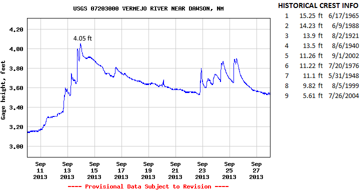
The Vermejo River near Dawson crested at 4.05 feet (106 cfs) at 1030pm MDT September 13, 2013. This event does not fall within the top 9 record events for this location. The record crest is 15.25 feet set back on June 17, 1965. No significant flooding was observed immediately along the Vermejo River. Action stage is 9 feet, minor flood stage 9 feet, moderate flood stage 13 feet, and major flood stage 16 feet.
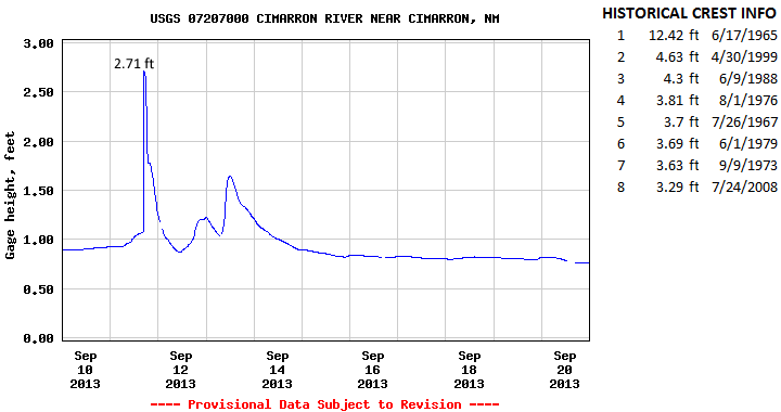
The Cimarron River near Cimarron crested at 2.71 feet (235 cfs) at 330pm MDT September 11, 2013. This crest does not fall into the top 8 record events for this location. It compares to a previous crest of 3.29 feet on July 24, 2008. The record crest is 12.42 feet set back on June 17, 1965. No flooding was reported across this area. Action stage is 5 feet , minor flood stage 5 feet, moderate flood stage 10 feet, and major flood stage 12.5 feet.
|
|||||||||||||||||||||||||||||||||