Albuquerque, NM
Weather Forecast Office
| Rainfall Summary: September 10-18, 2013 | |||||||||||||||||||||||||||||||
|
The table below is a comprehensive list of the more significant precipitation reports that were received for the 9-day event period.
|
|||||||||||||||||||||||||||||||
| Impact Summary | |||||||||||||||||||||||||||||||
|
|||||||||||||||||||||||||||||||
|
Hydrologic Summary
|
|||||||||||||||||||||||||||||||
|
There are no reporting locations in the Advanced Hydrologic Prediction Service database within Los Alamos County therefore no hydrographs are available for review. |
|||||||||||||||||||||||||||||||
|
Photos
|
|||||||||||||||||||||||||||||||
|
|
|||||||||||||||||||||||||||||||
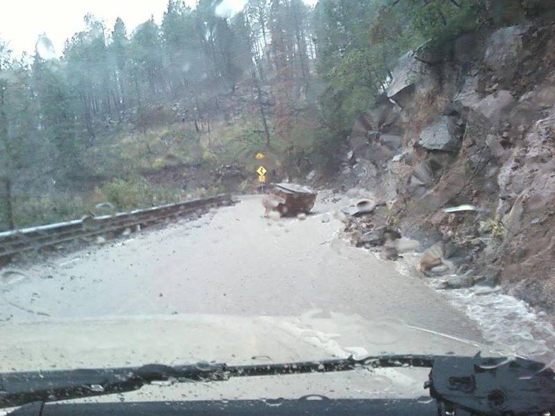
| Heavy rain and flooding created landslides in portions of Los Alamos and Sandoval counties. A large boulder is seen here that was dislodged and slid down the hillside adjacent to NM Highway 4. Image by Phil Taylor. | |||||||||||||||||||||||||||||||
Current Hazards
Outlooks
Submit A Storm Report
Severe and Hazardous Weather Info
Current Conditions
Surface Observations
Observed Precipitation
Satellite
Local Satellite Page
Local Observations Page
Map of Latest Wind and Precipitation Reports
Radar
National Radar
ABX Albuquerque Radar
FDX Cannon Air Force Base Radar
Forecasts
Fire Weather Forecasts
Area Forecast Discussion
Hourly View Forecast
Activity Planner
Aviation Forecasts
Local Forecast Page
Graphical Forecasts
Hydrology
Advanced Hydrologic Prediction Services
Local Hydrology Products
Climate and Past Weather
Climate Graphs
Drought
Severe T-Storm Climatology for NM
Local Data
Winter Climatology for NM
NOAA Climate Center
Climate Prediction Center
Local Programs
About Our Office
SKYWARN
NOAA Weather Radio
Local Studies and Features
Winter Weather Info, Safety Tips, and Climo
Severe Weather Info, Safety Tips, and Climo
Center Weather Service Unit
US Dept of Commerce
National Oceanic and Atmospheric Administration
National Weather Service
Albuquerque, NM
2341 Clark Carr Loop SE
Albuquerque, NM 87106-5633
(505) 243-0702
Comments? Questions? Please Contact Us.