| Rainfall Summary: September 10-18, 2013 | |||||||||||||||||||||||||||||||||||||||||||||
|
The table below is a comprehensive list of the more significant precipitation reports that were received for the 9-day event period.
|
|||||||||||||||||||||||||||||||||||||||||||||
| Impact Summary | |||||||||||||||||||||||||||||||||||||||||||||
|
|||||||||||||||||||||||||||||||||||||||||||||
|
Hydrologic Summary
|
|||||||||||||||||||||||||||||||||||||||||||||
|
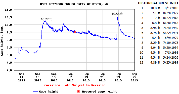
Embudo Creek at Dixon crested at 10.27 feet (592 cfs) at 1215pm MDT September 13, 2013 then again at 10.58 feet (938 cfs) at 815pm MDT September 22, 2013. The second crest of 10.58 feet is now the 2nd highest crest observed at this location and compares the record crest of 10.8 feet set back on August 1, 2010. No significant flooding was observed immediately along Embudo Creek. Action stage is 12 feet, minor flood stage 13 feet, and moderate flood stage 14 feet. No designation has been made for major flood stage.
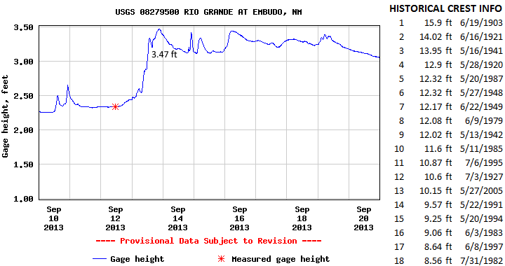
The Rio Grande at Embudo crested at 3.47 feet (721 cfs) at 900pm MDT September 13, 2013. This crest does not fall within the top 18 record events recorded at this location. The record crest is 15.9 feet set back on June 19, 1903. Action stage is 8 feet , minor flood stage 10 feet, moderate flood stage 12 feet, and major flood stage 15 feet.
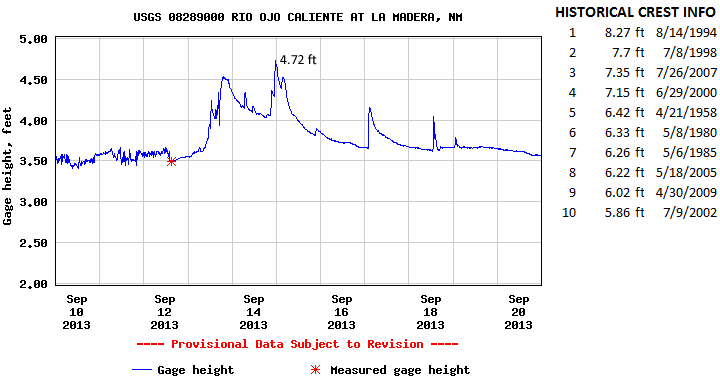
The Rio Ojo Caliente at La Medra crested at 4.72 feet (153 cfs) at 1130pm MDT September 14, 2013. This event does not fall within the top 10 record events at this location. The record crest is 8.27 feet set back on August 14, 1994. No significant flooding was reported in this area however this surge of water contributed to flooding downstream at Chamita. Action stage is 7 feet, minor flood stage 7 feet, moderate flood stage 9 feet, and major flood stage 10 feet.
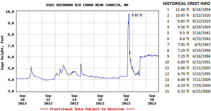
The Rio Chama near Chamita crested at 9.82 feet (9,450 cfs) at 500pm MDT September 18, 2013. This is now the 3rd highest crest for this location and compares to a previous crest of 9.65 feet set back on August 12, 1929 and 10.45 feet set back on May 22, 1920. The record crest is 11.68 feet set back on August 14, 1994. Flooding was reported in this area as numerous homes were inundated by flood waters. Roads became impassable due to persistent heavy rainfall. Action stage is 6.5 feet and minor flood stage 8 feet. There has been no determination of moderate and major flood stages.
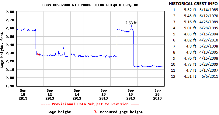
Releases from Abiquiu Dam created a crest of 2.63 feet (279 cfs) at 115pm MDT September 18, 2013 on the Rio Chama below Abiquiu Dam. This event does not fall within the top 12 record events listed. The record crest is 5.52 feet set back on May 14, 1985. No significant flooding was reported in this area. Action stage is 4.8 feet and minor flood stage 5.4 feet. There has been no determination of moderate and major flood stages.
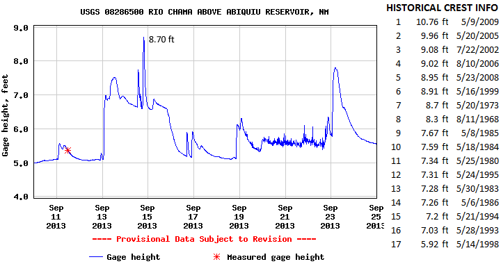
The Rio Chama above Abiquiu Resvoir crested at 8.7 feet (2,270 cfs) at 130pm MDT September 14, 2013. This is now the 7th highest crest for this location and ties a previous crest of 8.7 feet set back on May 20, 1973. The record crest is 10.76 feet set back on May 9, 2009. No significant flooding was reported in this area. Action stage is 10.2 feet and minor flood stage 11 feet. There has been no determination of moderate and major flood stages.
Releases at El Vado Dam created a crest of 3.16 feet (728 cfs) at 345am MDT September 13, 2013 on the Rio Chama below El Vado Dam. This event does not fall within the top 8 record events at this location. The record is 12 feet set back on May 22, 1920. No significant flooding was reported in this area. Action stage is 6.2 feet and minor flood stage 6.8 feet. There has been no determination of moderate and major flood stages.
|
|||||||||||||||||||||||||||||||||||||||||||||
|
|
|||||||||||||||||||||||||||||||||||||||||||||
|
Photos
|
|||||||||||||||||||||||||||||||||||||||||||||
|
|
|||||||||||||||||||||||||||||||||||||||||||||
|
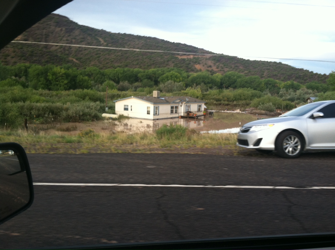
The Rio Chama flooded out of its banks, causing damage to nearby homes. Water reached just beneath the windows of this home near Chamita. Image taken on September 18, 2013. |
|||||||||||||||||||||||||||||||||||||||||||||
|
|
|||||||||||||||||||||||||||||||||||||||||||||
|
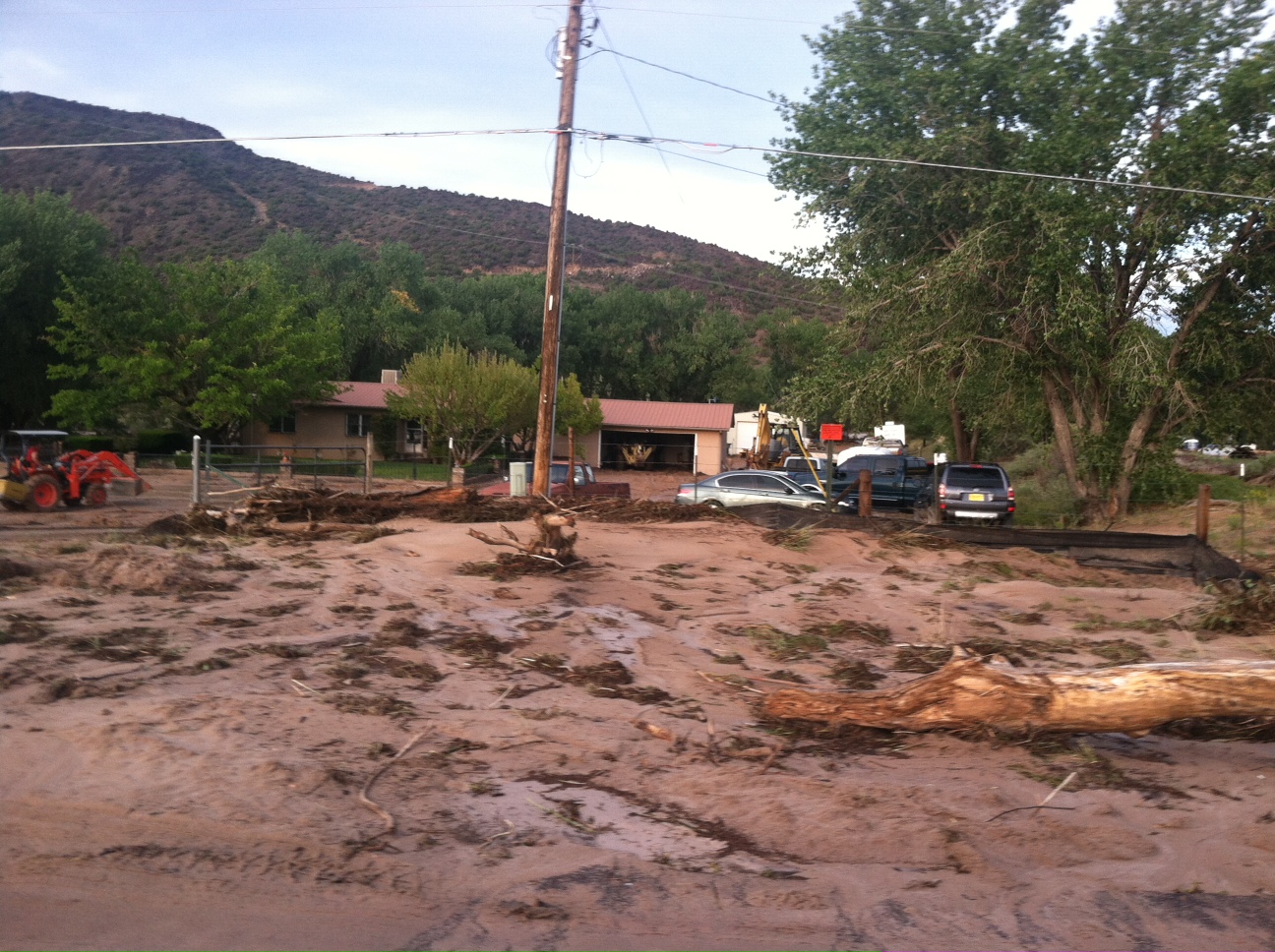
Mud and debris were carried close to homes near Medanales when the Rio Chama flooded on September 18, 2013. |
|||||||||||||||||||||||||||||||||||||||||||||
|
|
|||||||||||||||||||||||||||||||||||||||||||||
|
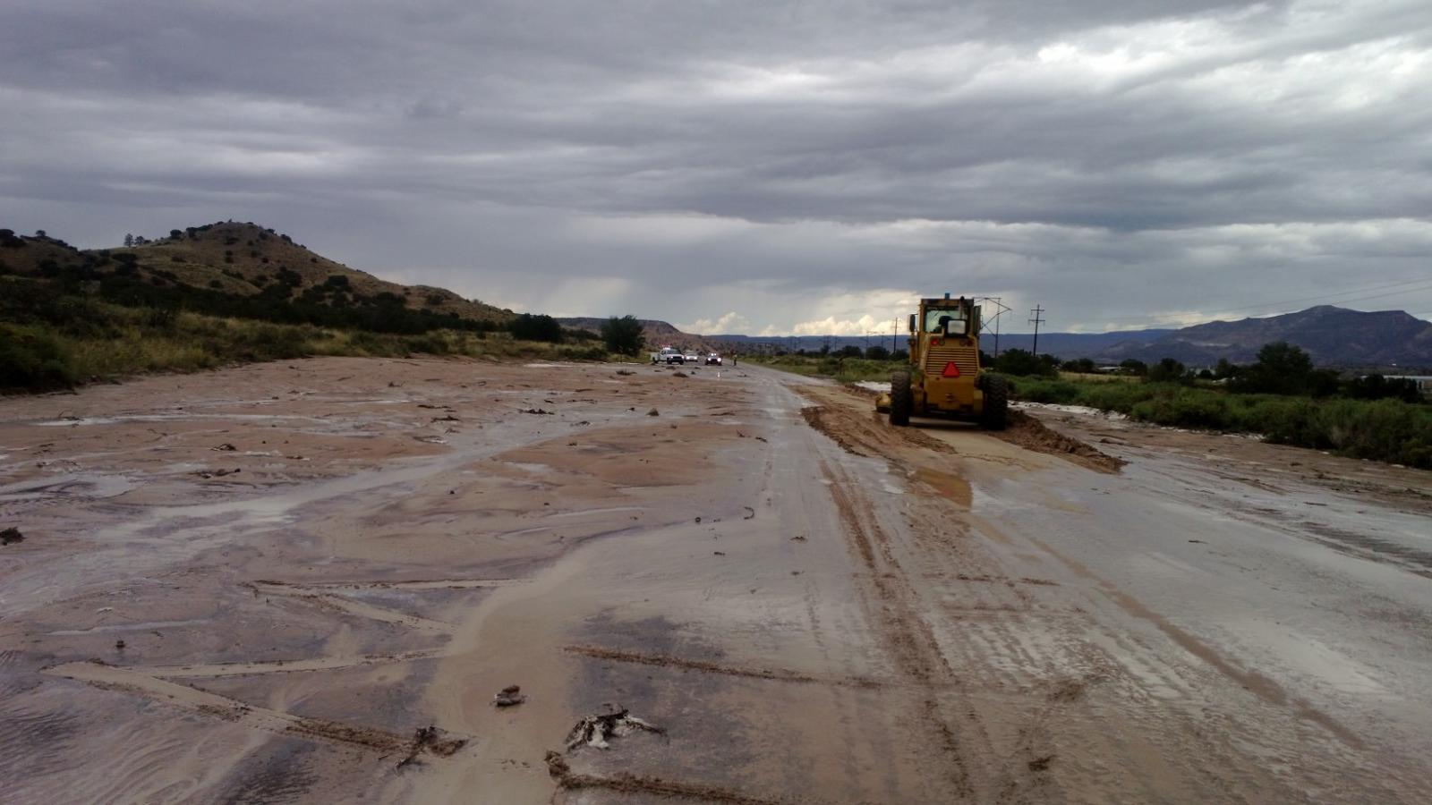
Road graders had to be used to clear mud and debris from U.S. Highway 84 near Chili on September 18, 2013. |
|||||||||||||||||||||||||||||||||||||||||||||