National Weather Service United States Department of Commerce

Sandoval Banner

Rainfall Summary: September 10-18, 2013

The table below is a comprehensive list of the more significant precipitation reports that were received for the 9-day event period.

Back to Historic Rainfall Feature

 Location (source) Precipitation Total (in)
 Los Posos(DRI) 7.33
 Redondo (DRI) 7.26
 Cochiti Dam (COOP) 6.83
 Valles Caldera (CRN) 6.67
 Valles Headquarters (DRI) 6.57
 Tower (RAWS) 6.48
 Valle Toledo (DRI) 5.18
 San Antonio (DRI) 4.59
 Rio Rancho 3.3 ENE (CoCoRaHS) 4.52
 Rio Rancho 2.2 SSE (CoCoRaHS) 4.52
 Rio Rancho 2.1 ENE (CoCoRaHS) 4.42
 Rio Rancho 2.5 S (CoCoRaHS) 4.41
 Rio Rancho 5.6 NE (CoCoRaHS) 4.19
 Rio Rancho 5.8 NNW (CoCoRaHS) 4.11
 Rio Rancho (COOP#1) 3.93
 Placitas 2.1 SE (CoCoRaHS) 3.91
 Rio Rancho (COOP#2) 3.89
 Jemez Dam (COOP) 3.85
 Sandia Lakes (RAWS) 3.33
 Jemez Springs (DRI) 3.21
 Corrales (COOP) 2.67
 Cuba (RAWS) 1.76


Impact Summary
Location Date Summary

 Cochito Pueblo

09/12-09/13/2013

NM 85 and 90 were initially flooded with 5,000 cfs flow through the area on the 12th then extremely heavy rainfall created severe flooding through the 13th. Numerous roads were flooded and partially destroyed. Kasha-Katuwe Tent Rocks National Monument was isolated. Evacuations took place in Cochiti Pueblo.

Bandelier National Monument

09/13/2013

Worst flash flood event ever recorded at Bandelier National Monument as the creek near the visitor center crested to 11 feet at 830am. Several points of infrastructure were damaged. The entrance road to the park was undermined and nearly destroyed.

Rio Rancho

09/13/2013

Northern Boulevard and 10th washed out by nearby arroyo. Southern washed over with significant amounts of water as well. Damage to roadway occurred near Hondo Avenue. Unser and 10th also washed out due to high water from arroyo. 12 families evacuated homes due to high water in nearby arroyo. Heavy flows in these arroyos led to flooding downstream into the Harvey Jones Canal in Corrales where the Harvey Jones Bridge was overtopped.

San Felipe Pueblo

09/13/2013

Flooding in the area near San Francisco Dam spillway was severe. Water Tank Dam was full and clogged. Many village roads were damaged. Approximately 40 occupants were sheltered at the San Felipe Elementary School.

San Ysidro

09/13/2013

Jemez River out of banks along NM 4 near San Ysidro damaging fiber line and water infrastructure. Several homes flooded with up to 3 feet of water. NM 4 has been damaged.

La Cueva

09/13/2013

Road in Elk Run Estates washed out near La Cueva. 100 residences in La Cueva reported loss of telephone service.

Sile

09/13/2013

All roads washed out in the community of Sile.

Algodones

09/14/2013

Water and debris flooding over Interstate 25 near Algodones.

San Felipe Pueblo

09/14/2013

Mud and water washed into several homes in San Felipe Pueblo. One foot of mud and rocks covered portions of the San Felipe Casino gas station parking lot. A 2 feet section of the lot west of the casino was undermined exposing a large conduit.


Hydrologic Summary

The Rio Grande at San Felipe crested at 7.73 feet (9,490 cfs) at 130pm MDT September 13, 2013.  This is now the 7th highest crest observed at this location and compares to a previous crest of 7.55 feet on August 17, 1943 and 8.59 feet on April 24, 1942.  The record crest is 11.13 feet set back on June 26, 1937.  No significant flooding was observed immediately along the Rio Grande however several nearby creeks and arroyos leading into this basin produced damaging floods to nearby residential and commercial structures.  Action stage is 8 feet, minor flood stage 8.5 feet, moderate flood stage 9.5 feet, and major flood stage 11 feet. 


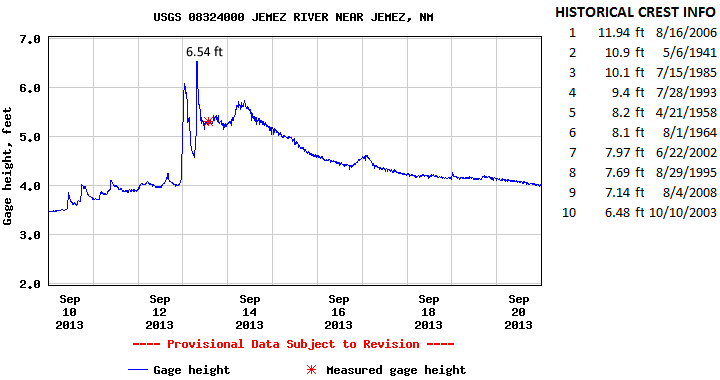
The Jemez River at Jemez crested at 6.54 feet (1,010 cfs) at 745am MDT September 13, 2013.  This crest is now the 10th highest on record for this location and compares to a previous crest of 6.48 feet on October 10, 2003 and 7.14 feet on August 4, 2008.  The record crest is 11.94 feet set back on August 16, 2006.  Flooding was reported along the Jemez River primarily downstream toward the community of San Ysidro were homes were flooded and portions NM 4 were flooded.  Action stage is 8 feet , minor flood stage 8 feet, moderate flood stage 10 feet, and major flood stage 12 feet.


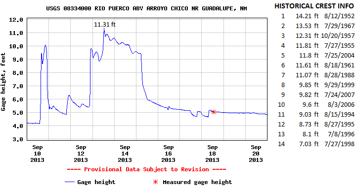
The Rio Puerco near Guadalupe crested at 11.31 feet (1,395 cfs) at 1245pm MDT September 13, 2013.  This is now the 7th highest crest for this location and compares to a previous crest of 11.07 feet set back on August 28, 1988 and 11.61 feet set back on August 18, 1961.  No significant flooding was reported in this area however this surge of water contributed to flooding downstream at Bernardo.  Action stage is 14 feet and minor flood stage 14 feet.  There has been no determination of moderate and major flood stages.