|
Event Summary
|
|||||||||||
|
An upper level low pressure system over southern California began spreading increasingly moist southerly flow into New Mexico on the 6th. The first round of showers and thunderstorms focused mainly over western New Mexico where strong outflow winds impacted the Four Corners region. Wind damage was reported around Bloomfield and Aztec. The upper level low pressure system moved slowly east into western Arizona on the 7th and allowed deeper moisture and instability to increase over New Mexico. The most unstable conditions focused over southeastern NM where a cluster of thunderstorms developed across Eddy and Chaves counties during the late afternoon hours. One of these storms crossed the Roswell area and produced a peak wind gust to 64 mph. The upper level low pressure system inched closer to New Mexico on the 8th and began spreading more widespread instability and near-record atmospheric moisture across the region. Discrete thunderstorms developed over the southeastern plains shortly after 3pm then spread north across the east central plains as large clusters and linear segments. Large hail, strong winds, and heavy rainfall impacted many locations from Roswell to Fort Sumner, the Interstate 40 corridor between Santa Rosa and Tucumcari, and into Harding County. The first tornado of 2017 developed near Roy, New Mexico. The most widespread, significant, severe weather developed on May 9th as the center of the upper level low moved over New Mexico. Showers and thunderstorms developed during the early morning hours over central and eastern New Mexico then spread northeastward while expanding in coverage and intensity through the afternoon. Many locations from the Rio Grande Valley eastward saw large, damaging hail, tornados, funnel clouds, severe winds, and minor flooding. A brief, weak tornado impacted the west side of Santa Fe near NM-599 and resulted in minor damage. Other weak tornados were spotted near Clines Corners, Carrizozo, and Wagon Mound. Severe thunderstorms with large hail, torrential rainfall, and strong winds persisted well into the evening across eastern New Mexico. The low pressure system plaguing the area for several days finally exited the state on the 10th, but not before producing one more supercell thunderstorm and a associated tornado east of Raton near the Colorado border. |
|||||||||||
|
Satellite & Radar
|
|||||||||||
|
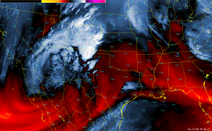
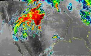
An unseasonably deep upper level low pressure system near the California coastline on May 5th settled into the northern Baja region on May 6th. Deep southerly flow ahead of this system allowed mid and upper level atmospheric moisture levels to gradually increase over New Mexico. Meanwhile, low level moisture over Texas began surging northwest into the area as surface winds turned more to the east and southeast across eastern New Mexico. The combination of deep moisture, upper level forcing, and afternoon heating provided sufficient instability for showers and thunderstorms across New Mexico for several days. The satellite imagery linked within the NWS YouTube videos below shows how the entire system evolved on May 9th. The top-left video is the water vapor channel, the top-right video is the infrared channel, the bottom-left video is the composite radar reflectivity, and the bottom-right video is the maximum estimated hail size. Each YouTube video has an associated description of the more notable weather features.
|
|||||||||||
|
Storm Report Summary
|
|||||||||||
|
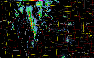
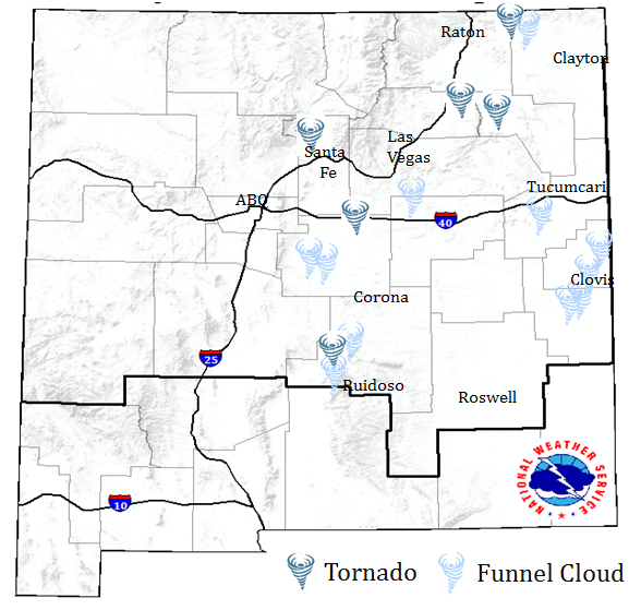
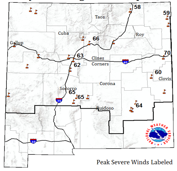
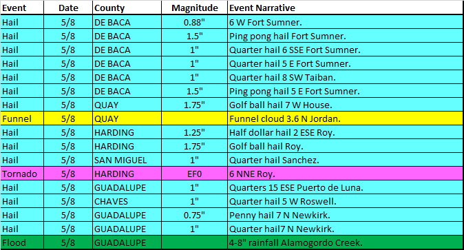
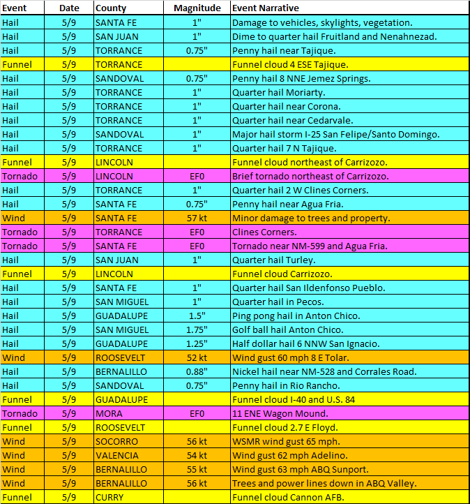
The active weather during the period from May 6th to May 10th resulted in 85 severe weather reports across northern and central New Mexico. There were 6 confirmed tornados, 54 reports of large hail, 14 high wind gusts or wind damage reports, and 1 flash flood. The following is a breakdown of severe weather reports for the May 6-10, 2017 period. Click the image thumbnails below to view a larger map of tornado/funnel cloud, hail, and wind reports. TORNADO/FUNNEL HAIL WIND
May 6th: The combination of downburst winds and thunderstorm outflows produced wind damage across the Bloomfield and Aztec area. Numerous trees and power lines were blown down producing power outages and damage to homes and vehicles. An isolated thunderstorm over the Raton area also produced strong winds but with no damage.
May 7th: A cluster of thunderstorms moving north across Eddy and Chaves counties produced a peak wind gust to 64 mph at Roswell shortly after sunset. No significant damage occurred with these winds.
May 8th: The first round of thunderstorms produced ping pong ball size hail in the Fort Sumner area. The first tornado of the 2017 severe weather season touched down to the north of Roy just after 6 pm. A second cluster of thunderstorms developed over Chaves County around 8pm resulting in golf ball size hail on the west side of Roswell. Heavy rainfall that trained over the same area of southeastern Guadalupe and northeastern De Baca counties generated torrential rainfall amounts within the Alamogordo Creek drainage. Video of flash flooding was captured along the creek near U.S. Highway 84 north of Fort Sumner.
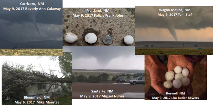
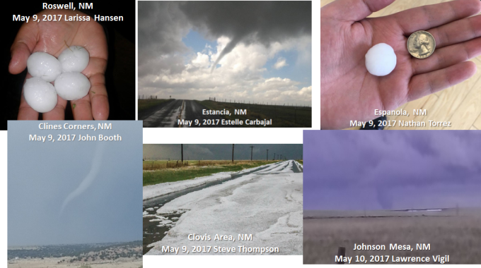
May 9th: Isolated thunderstorms developed shortly after midnight in the area from Santa Fe to Farmington and produced quarter size hail with heavy rain and and strong winds. A large area of showers and thunderstorms developed shortly after sunrise over central New Mexico and moved north across the Albuquerque and Santa Fe metro areas through the early afternoon. Several funnel clouds and large hail were reported around the Estancia Valley. A brief tornado developed near the Santa Fe airport shortly after noon with minor damage reported. A major hailstorm struck the Interstate 25 corridor near Kewa Pueblo, resulting in damage to homes and vehicles. The next wave of storms that developed over central New Mexico produced tornadoes near Carrizozo, Clines Corners, and Wagon Mound. Large hail up to the size of golf balls was also reported with these storms. More storms firing up around the Albuquerque metro area produced nickel to quarter size hail from Rio Rancho north into the Jemez Mountains. Severe thunderstorms continued to pound eastern New Mexico well into the evening hours with golf ball to hen egg size hail producing damage in areas around Roswell and Tucumcari.
May 10th: An isolated thunderstorm that developed just south of U.S. Highway 87 east of Raton moved north and produced a brief tornado along the Johnson Mesa near NM-72. The tornado moved through rural countryside and produced no damage.
|
|||||||||||
|
Photo Summary
|
|||||||||||
|
Many thanks to all the folks who submitted photos to various social media and NWS customer platforms during this significant severe weather event. These photos serve as an excellent compliment to the suite of satellite, radar, surface observations, and spotter weather reports. This information assists forecasters in providing improved warning services for the protection of life and property. |