 |
| Storms in New Mexico Around Thanksgiving |
|
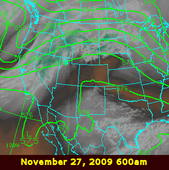
The current storm has brought plenty of Thanksgiving snow to the state. How does it compare to previous Thanksgivings? Past years have seen storms on or around Thanksgiving. In 2009, a long duration storm began on the 28th, just two days after Thanksgiving. The storm continued into early December, depositing rain over lower elevations and snow over the high terrain, focusing mostly on the south central mountains.
|
|||||||||||||||||||||||||||||||
|
November 27th, 2008 Thanksgiving: Widespread Rain; Snow in the North |
|||||||||||||||||||||||||||||||
|
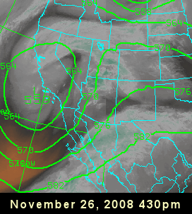
After a week of quiet, mild weather across New Mexico, a storm from off the California coast moved inland just in time to bring rain and higher elevation snow to the state on Thanksgiving. This made for a turkey of a day in many locations. The storm organized off the California coast on the 24th and 25th, moved inland on the 26th, then weakened as it approached the four corners region on the 27th. The two water vapor satellite images below, overlaid with 500 mb heights, show the storm on the afternoon of the 26th and late morning of the 27th.
|
|||||||||||||||||||||||||||||||
|
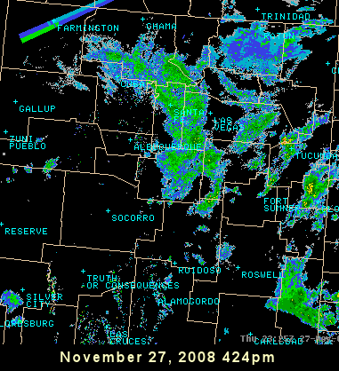
Despite the storm weakening as it treked across California and Arizona, the system was able to draw quite a bit of moisture north into New Mexico ahead of it. The radar image below reveals some of the precipitation that fell during the day. The strange looking echo over Farmington is not a precipitation echo at all, but rather a sun spike. It occurs when the sun is just setting and the radar beam passes directly in front of the sun. Note how it is angled toward the southwest, since the sun has shifted to the southern hemisphere as we approach winter. In the summer, the sun spike will be aimed toward the northwest at sunset. The sun spikes also occur right at sunrise and will be aimed toward the northeast (in summer) and southeast (in winter). |
|||||||||||||||||||||||||||||||
 |
|||||||||||||||||||||||||||||||
|
At the same time moisture was racing north into the state, a cold front moved south over the eastern plains during the day on the 27th. Enough cold air was present to send temperatures plummeting into the 30s over the northeast. This turned the rain to snow across the northeast highlands and far northeast plains during the course of the day. Snow also fell over the northern mountains. The tables below list some of the higher snowfall totals from the 27th. Click here for a more detailed map with additional snowfall totals.
|
|||||||||||||||||||||||||||||||
|
In 2007, a storm hit on the 23rd, just one day after Thanksgiving, and continued through the 24th. A strong cold front had moved through the state on the 21st, with much colder air behind it. Snow accumulated over the mountains and eastern plains. |
|||||||||||||||||||||||||||||||
|
Nov 23-24, 2007: First Widespread Snow of the Season in New Mexico |
|||||||||||||||||||||||||||||||
|
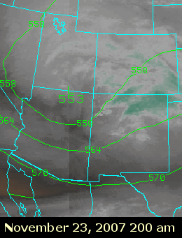
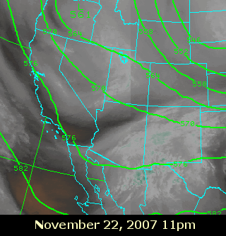
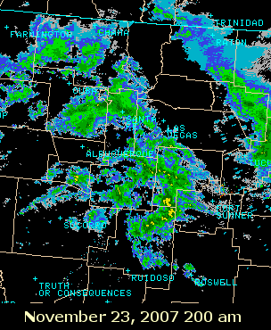
A strong cold front blasted south and west across New Mexico on the 21st, while a weak upper level disturbance crossed southern areas of the state on the 22nd, delivering a little snow. A stronger storm from the pacific Northwest dropped southeast over Arizona and New Mexico on the 23rd and 24th, strengthening as it did so. The water vapor satellite image to the right shows the two systems on the morning of the 22nd, while the image below shows the advancing second system early on the 23rd. With the cold air in place, the second storm was able to generate mostly snow over the Land of Enchantment. The favored areas were the northern mounains and their adjacent high plains, where up to xx inches was able to accumulate. The radar image below and to the right shows a sample of the precipitation early on the 23rd.
|
 |
||||||||||||||||||||||||||||||
|
|
 |
||||||||||||||||||||||||||||||
|
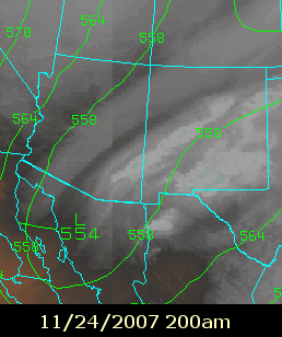
As the storm moved southeast and strengthened late on the 23rd and 24th, the snow shifted to the southern tier counties. Below (lef) is another water vapor image early on the 24th, and a radar image (right) showing the more concentrated rain and snow over the south. Farther below is a table displaying some of the higher snowfall totals from the 21st through 24th. |
|||||||||||||||||||||||||||||||
 |
.png) |
||||||||||||||||||||||||||||||
|
|||||||||||||||||||||||||||||||