|
|
| Near Clovis, Photo by Jessica-Marie Barriere |
| Home | Introduction | Wildfires | Lightning | Flash Floods |
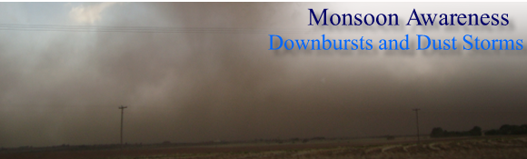
Downburst Winds & Dust Storms |
Heat Stress |
 |
|||||||
|
Downburst Winds |
|||||||
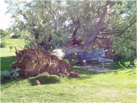
The physical properties of a downburst are completely different from those of a tornado. Often the damage is very localized, as in the photo above, or in some cases, can be widespread. This tree and a few others were uprooted on a golf course after thunderstorm downburst winds occurred. However, most of the trees in the golf course were not damaged. When rain descends from a thunderstorm, evaporative cooling and drag act to strengthen the downward velocity of the downdraft. At times, the precipitation will evaporate prior to reaching the ground. Once the accelerating air reaches the ground, it will spread laterally, often with a vortex or "curl" on the lead edge. Downburst damage will radiate from a central point as the descending column spreads out when impacting the surface, whereas tornado damage tends toward convergent damage consistent with rotating winds. |
|||||||
|
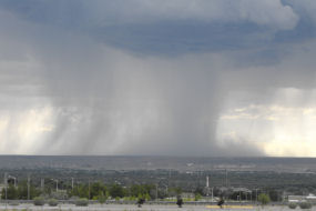
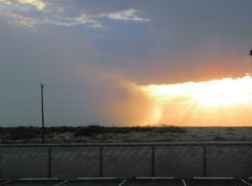
On June 19 of 2010, a local photographer was able to capture a microburst event associated with shallow convection and virga during sunset in Albuquerque (lower left). The beauty of the photograph can be misleading - as these virga showers are producing strong downburst winds. The local observation at the Albuquerque Sunport reported a peak gust of 57 mph. Around the same time, a large fuel tank under construction near the airport sustained extensive damage from the microburst winds (lower left). |
|||||||
 |
 |
||||||
| Photo by Leah Robertson | Photo courtesy of Gene Jaramillo | ||||||
|
To differentiate between tornado and downburst damage, an assessment is completed post-storm of the affected areas in order to determine the type of impact the winds had on structures and vegetation. If a downburst is found to have occurred, and the area impacted with 2.5 mi or less, it is termed a Microburst, whereas if the impacted area is greater than 2.5 mi, it is then termed a Macroburst. |
|||||||
|
|||||||
|
Dust Storms |
|||||||
|
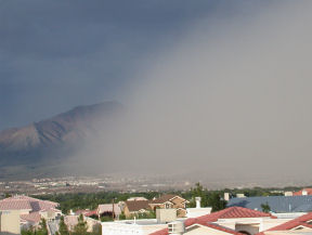
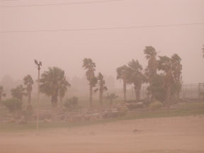
While downburst winds often do produce local, short-lived areas of blowing dust, larger convective clusters can result in wind spread areas of blowing dust, at times persisting for 30 to 60 minutes. The photos below are from El Paso (left) and Santa Teresa (right) and are examples of more extreme dust storms in southern New Mexico. |
|||||||
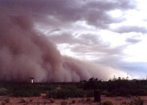
The most extreme cases of dust storms in New Mexico occur in the extreme southern portions of the state, and are referred to as "haboobs." A haboob is an extreme dust storm that can persist for 1 to 3 hours. The onset of the dust is extreme - it is virtually a wall of dust, as shown in the photos below from near Columbus, NM (left) and El Paso, TX (right). |
|||||||
|
|||||||
 |
|||||||
Downburst Wind Safety:
Dust Storm Safety:
|
|||||||
 |
|||||||
|
Storm Data has listed 20 wind events as either dry or wet microbursts since 1990. There are likely many other thunderstorm wind events that could be classified as microbursts or macrobursts. Winds up to 80 mph were reported with a microburst in Chama on June 2, 1998. On a somewhat larger scale, on August 4, 1998, a line of thunderstorms moving off the San Andres Range produced a macroburst with winds that measured 112 mph at the White Sands Missile Range. The anemometer at Holloman AFB recorded speeds of 75 mph before breaking! The core of strongest winds moved over uninhabited military land, but considerable tree damage and some structural damage occurred well to the east near Alamogordo in Bolles Acres. It was also reported that a vehicle was blown sideways for two blocks. Storm Data also lists 6 dusts storms since 1990. A dust storm in Lordsburg on the 4th of July, 1974 injured 13 people! |
|||||||
 |
|||||||
|
Downbursts are particularly strong downdrafts from thunderstorms. Downbursts that occur in precipitation-free air or with virga (evaporating rainfall) are known as dry downbursts; those accompanied with precipitation are known as wet downbursts. Most downbursts are less than 2.5 miles in extent: these are called microbursts. Downbursts larger than 2.5 miles in extent are sometimes called macrobursts. Downbursts can occur over large areas. In the extreme case, a derecho (a widespread and long-lived, violent convectively-induced straight-line windstorm that is associated with a fast-moving band of severe thunderstorms in the form of a squall line) can cover a huge area more than 200 miles wide and over 1000 miles long. Derechos have been known to last up to 12 hours or more, and are associated with some of the most intense straight-line winds. The generative process of a derecho is somewhat different from that of most downbursts. |
|||||||