
A heat wave over the Southwest will intensify this week, peaking and expanding into the Intermountain West and northern High Plains this weekend. Critical to extremely critical fire weather conditions are forecast from the Northwest and the northern Great Basin this weekend. Particularly Dangerous Situation Red Flag Warnings have been issued. Read More >
Albuquerque, NM
Weather Forecast Office
Winter Weather Awareness |
Staying Safe |
Mantenerse Seguro |
Winter Products |
Cold Season Precipitation Types |
Climatology |
|
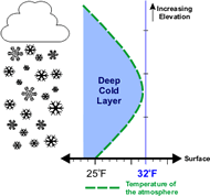
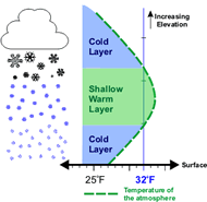
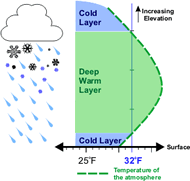
How do the various forms of winter precipitation develop when when temperatures at or above the surface dip below freezing?
|
| Snow | Sleet | Freezing Rain |
|
|
|
 |
 |
 |
Current Hazards
Outlooks
Submit A Storm Report
Severe and Hazardous Weather Info
Current Conditions
Surface Observations
Observed Precipitation
Satellite
Local Satellite Page
Local Observations Page
Map of Latest Wind and Precipitation Reports
Radar
National Radar
ABX Albuquerque Radar
FDX Cannon Air Force Base Radar
Forecasts
Fire Weather Forecasts
Area Forecast Discussion
Hourly View Forecast
Activity Planner
Aviation Forecasts
Local Forecast Page
Graphical Forecasts
Hydrology
Advanced Hydrologic Prediction Services
Local Hydrology Products
Climate and Past Weather
Climate Graphs
Drought
Severe T-Storm Climatology for NM
Local Data
Winter Climatology for NM
NOAA Climate Center
Climate Prediction Center
Local Programs
About Our Office
SKYWARN
NOAA Weather Radio
Local Studies and Features
Winter Weather Info, Safety Tips, and Climo
Severe Weather Info, Safety Tips, and Climo
Center Weather Service Unit
US Dept of Commerce
National Oceanic and Atmospheric Administration
National Weather Service
Albuquerque, NM
2341 Clark Carr Loop SE
Albuquerque, NM 87106-5633
(505) 243-0702
Comments? Questions? Please Contact Us.

