NWS Birmingham, Alabama
Weather Forecast Office
Collirene Tornado - February 17, 2008
|
Rating:
(Click for EF Scale) |
EF-2
|
|
Maximum Wind:
|
120 mph
|
|
Injuries/Fatalities:
|
10 injuries
|
|
Path Length:
|
11.0
|
|
Maximum Path Width:
|
225 yards
|
|
Start:
|
32.1715/-86.8239 at 224 PM
|
|
End:
|
32.2836/-86.6903 at 237 PM
|
A National Weather Service Damage Assessment Team has surveyed the damage in Lowndes County and it has been determined that the damage was the result of a tornado. The tornado has been rated on EF-2 on the Enhanced Fujita Scale. Damage estimates were consistent with winds around 120 mph. The tornado damage path was 11 miles long and was 225 yards wide at its widest point.
The tornado tornado touched down in the Collirene Community, approximately 14 miles west of Hayneville. The tornado tracked northeastward and ended just north of US Highway 80. At least 11 structures were damaged with three of these being completely destroyed. Hundreds of trees were either snapped or were uprooted along the damage path. The most extensive damage occurred in and near the Collirene Community. Ten injuries were attributed to this tornado. A Tornado Warning was in effect from 145 pm until 245 pm.
The National Weather Service would like to thank the Lowndes County Emergency Management Agency for assistance in the assessment process.
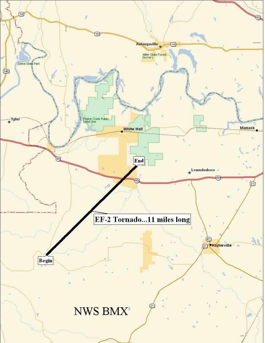 Tornado Damage Path |
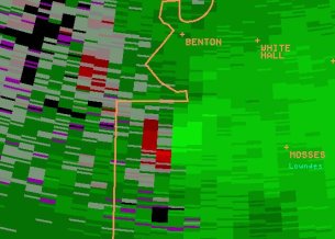 KBMX Storm Relative Velocity Image near the time of tornado touch down |
Current Hazards
National Outlooks
Tropical
Local Storm Reports
Public Information Statement
Graphical Hazardous Weather Outlook
Current Conditions
Regional Weather Roundup
Rivers and Lakes
Drought Monitor
Forecasts
Graphical Forecasts
Forecast Discussion
Air Quality
Fire Weather
Aviation Weather
Climate and Past Weather
Past Events
Storm Data
Tornado Database
Daily Rainfall Plots
Tropical Cyclone Reports
Monthly Climate
Annual Climate
Warnings and Other Products
Tornado Warnings
Severe Thunderstorm Warnings
Flash Flood Warnings
Winter Weather Warnings
Special Weather Statements
Non-Precipitation Warnings
Flood/River Flood Warnings
Productos en Español
Conciencia y Preparación
Previsión de 7 Días
Weather Safety
NOAA Weather Radio
Severe Weather Preparedness
Severe Safety Rules
Tornado Safety Rules
Severe Safety w/ ASL
Awareness Weeks
Severe Weather
Hurricane Preparedness
Summer Safety Campaign
Winter Weather
US Dept of Commerce
National Oceanic and Atmospheric Administration
National Weather Service
NWS Birmingham, Alabama
465 Weathervane Road
Calera, AL 35040
205-664-3010
Comments? Questions? Please Contact Us.

