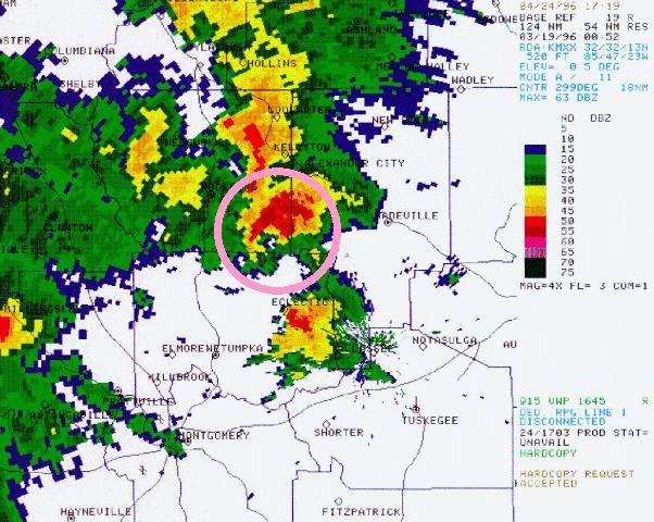
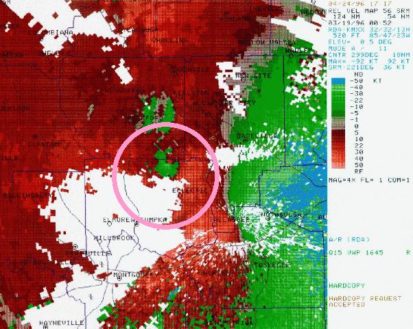
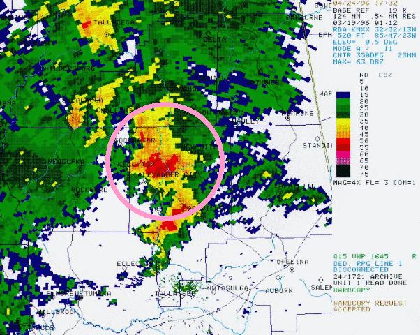
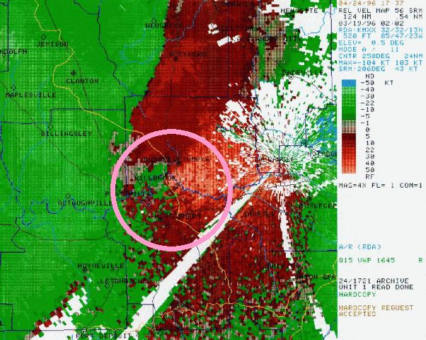
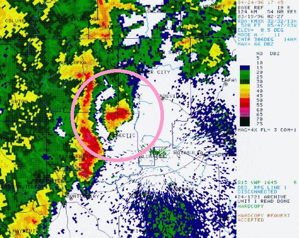
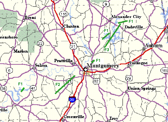
In this survey you will see two thumbnail radar images for each tornado track. The one on the left is reflectivity, and on the right is storm relative velocity. If you click on the thumbnails you will get the larger images. Each image has a circle around the storm in question. The radar site is the Maxwell AFB WSR-88D located in Macon County, AL. There is also a map (43KB) of the area depicting the six tornado tracks. The approximate location of the tracks are shown by green lines.
National Weather Service Meteorologists have had an opportunity to complete ground and aerial surveys of damage caused by thunderstorms during the late afternoon and evening of March 18, 1996. The surveys concentrated on storms in central Alabama affecting Dallas, Lowndes, Montgomery, Elmore, Coosa, and Tallapoosa Counties. Six individual tornado tracks produced by three thunderstorms are spelled out in the following information.
Dallas County:
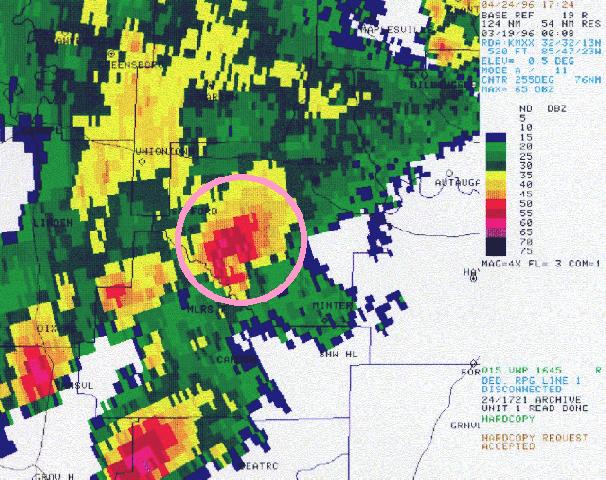
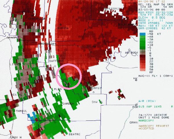 A small tornado touched down along the Alabama river just inside Dallas County or about 10 miles south of Orrville. It damaged several houses and mobile homes and at least one farm structure. Numerous trees were also snapped off and uprooted. The tornado was on the ground for about 4 miles with a width of about 70 yards. The tornado intensity was rated as F1 on the Fujita Scale.
The tornado first touched down at 605 p.m. CST and had ended by 610 p.m. CST. A tornado warning was issued by the national weather service at 544 p.m. CST valid until 645 p.m. CST.
Elmore/Coosa/Tallapoosa Counties:
 A tornado track was found that began about 7 miles northwest of Eclectic and just west of lake Martin. The path crossed the extreme southeast corner of Coosa County and crossed just barely into Tallapoosa County. The track was determined strictly from a ground survey without the benefit of an aerial view, so the track dimensions are preliminary. The track was about 6 miles along the ground and was about 100 yards wide. The tornado intensity was evaluated as an F1. A number of homes sustained damage in the Coosa County section on the edge of lake Martin.
The tornado first touched down around 652 p.m. and continued for approximately 10 minutes ending around 702 p.m. CST. A tornado warning was issued for Elmore County at 633 p.m. CST valid until 730pm CST. A tornado warning was issued for Coosa County at 604 p.m. and was extended at 659 valid until 730pm CST. A tornado warning was issued for Tallapoosa County at 652 p.m. valid to 745pm CST.
Tallapoosa County:
 A small tornado rated as an F1 occurred in central Tallapoosa County around 712 p.m. CST. It began just north of Jackson's Gap and tracked about 6 miles along the ground running primarily through farm land. Several structures were damaged along with numerous trees down. The damage path was about 90 yards wide. The tornado began at 712 p.m. and continued for about 10 minutes or so ending around 722 p.m. CST. A tornado warning was issued for Tallapoosa County at 652 p.m. valid until 745 p.m. CST.
Lowndes/Montgomery Counties:
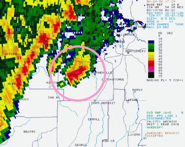
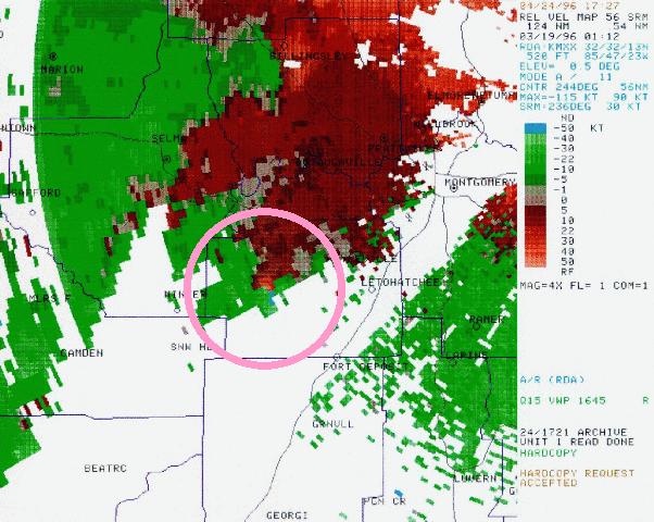 An F2 tornado began about 1.5 miles south of Gordonville, in central Lowndes County at 712 p.m. CST. The tornado moved on a northeasterly course, taking it just south and east of Moses and just north of Hayneville. The tornado crossed county road 21 between 5 and 6 miles north-northeast of Hayneville. The tornado continued to produce damage as it crossed the Lowndes/Montgomery County line just south of U. S. 80 around 739 p.m. The tornado dissipated about three miles into Montgomery County just north of U. S. 80 in extreme northwestern Montgomery County around 743 p.m. CST.
It has been reported that there were two people injured when a couple of mobile homes located between 5 and 6 miles north-northeast of Hayneville were destroyed. A tornado warning was issued for Lowndes County at 639 p.m. valid to 800 p.m. A tornado warning for Montgomery County was issued at 720 p.m. valid until 815 p.m.
Elmore County:
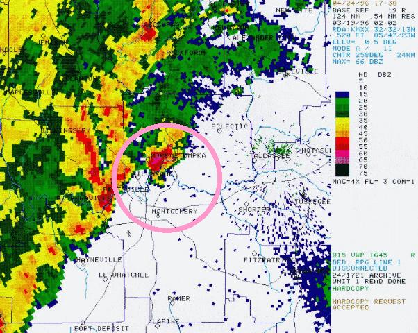
 A very short, less than one mile, tornado damage path occurred about 4 miles south of Wetumpka and just west of the U.S. 231 rest area. Tornado intensity was evaluated as an F1 with a path length less than one mile and a path width of about 70 yards. A commercial structure was severely damaged and several homes in the immediate area sustained minor damage. The tornado occurred at 805 p.m. CST and lasted less than 2 minutes. A tornado warning was issued for Elmore County at 744 p.m. valid until 845 p.m.
Elmore/Tallapoosa Counties:
 This tornado path began on the northeast side of Eclectic and extended for 10 miles in Elmore County crossing the Elmore/Tallapoosa county line just east of highway 63. The tornado continued for another 14 miles in Tallapoosa County crossing lake Martin and ending on the north side of Jackson's Gap. The tornado path width was approximately a quarter of a mile with a length of 24 miles. This tornado was classified an F3 and appeared to be the strongest of all of those surveyed in this event.
There was damage to buildings all along the track, however, some of the most intense damage occurred as the tornado emerged from crossing lake Martin in the Peckerwood area just southwest of Jackson's Gap. A number of houses and mobile homes sustained significant damage in this area. The tornado began at 823 p.m. CST crossing into Tallapoosa County around 837 p.m. The tornado ended around 855 p.m. CST. A tornado warning was issued for Elmore County at 744 p.m. valid until 845 p.m. A tornado warning was issued for Tallapoosa County at 821 p.m. valid until 930 p.m. CST.

