|
Event Summary
|
|
EF-3
|
|
Estimated Maximum Wind:
|
140 mph
|
|
Injuries/Fatalities:
|
5 Injuries |
|
Damage Path Length:
|
50.36 miles
|
|
Maximum Path Width:
|
1100 yards
|
|
Approximate Start Point/Time:
|
3 SW West Blocton
33.1157/-87.1707
at 12:53 pm CDT
|
|
Approximate End Point/Time:
|
2 SSE Camp Winnataska
33.5047/-86.4381
at 2:02 pm CDT
|
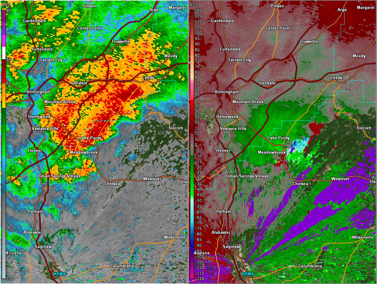
National Weather Service meteorologists surveyed the damage along a path from northern Bibb County northeastward to the Shelby/St. Clair County line near Vandiver and determined it was the result of an EF-3 tornado.
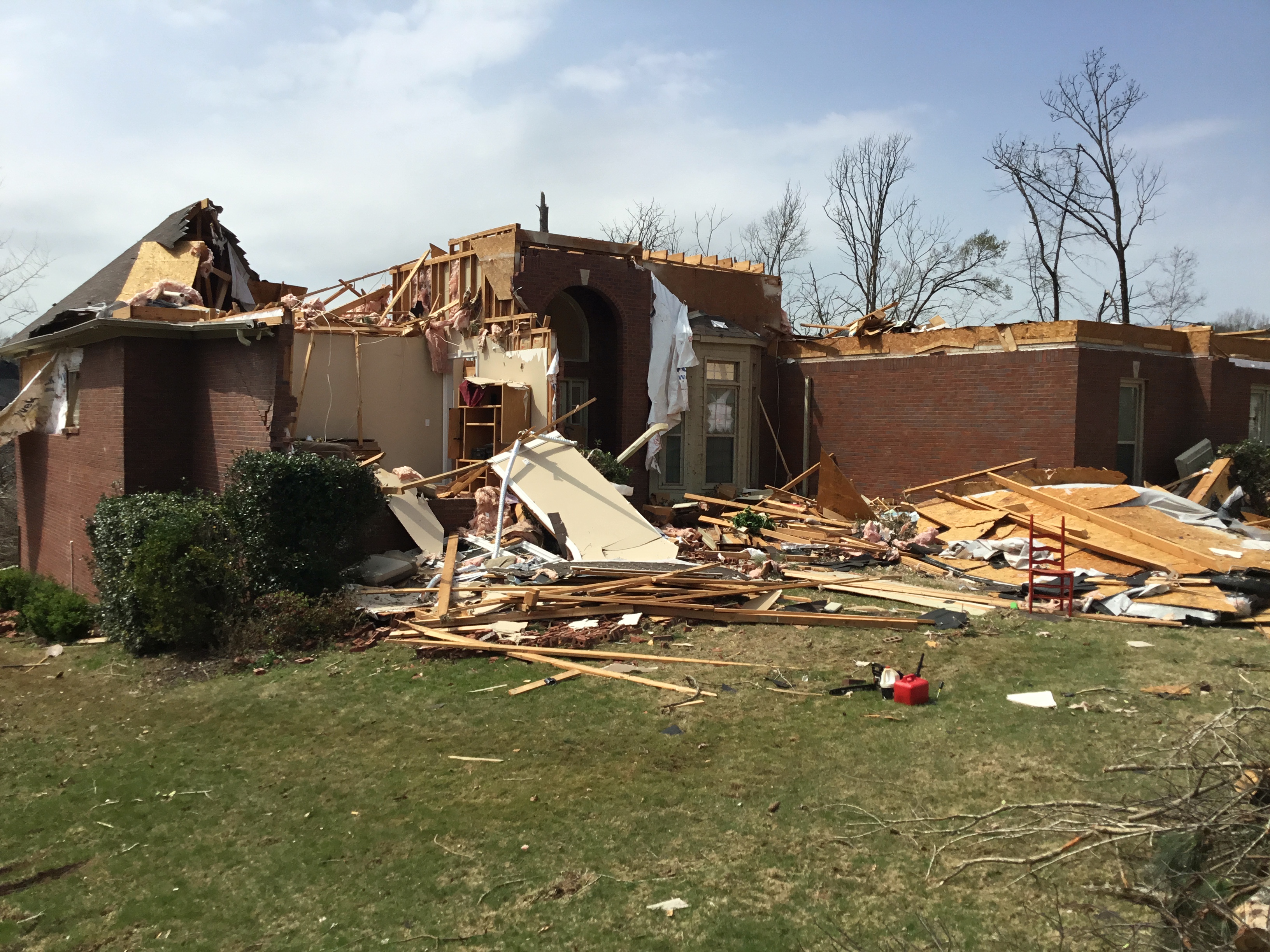
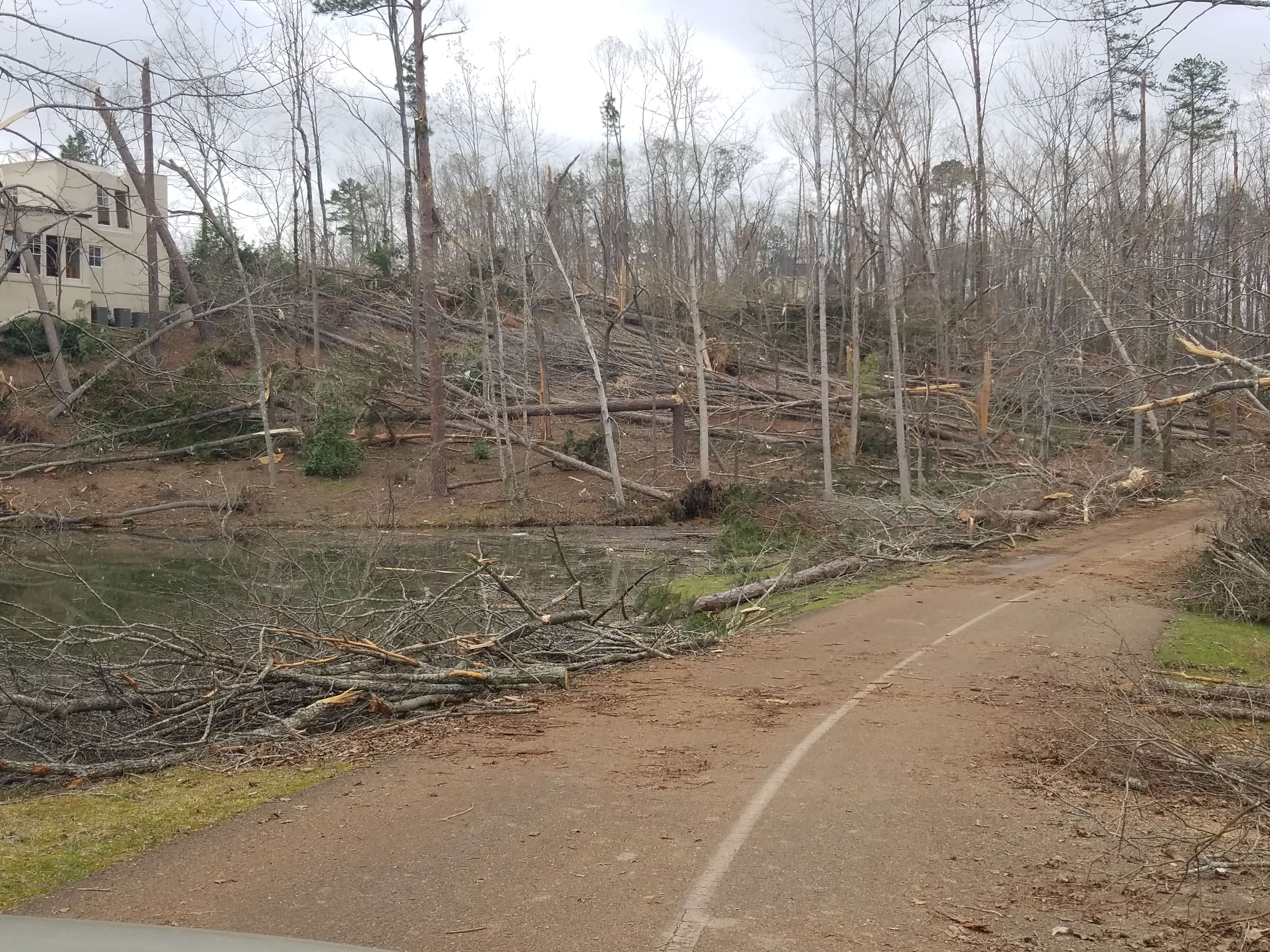
This long track tornado formed along Bibb County Highway 24 west of Highway 5. The tornado moved northeastward, crossing Highway 5 northwest of West Blocton, causing tree and shingle damage. The tornado strengthened to EF2 intensity as it moved northeastward into a wooded area where numerous trees were snapped. The tornado weakened to EF0 to EF1 intensity as it crossed into Shelby County south of Shelby County Highway 13, continuing to down trees. It continued to move northeastward through a wooded area along the Cahaba River, paralleling County Highway 13. As the tornado moved into Helena, it caused shingle damage to several homes in the neighborhoods near Old Cahaba Parkway and Hillsboro Parkway. A house that was under construction also collapsed. The tornado intensified again as it crossed Buck Creek near Old Town Helena, snapping numerous trees and causing roof damage. A couple homes near Cunningham Drive suffered partial roof loss. The tornado weakened as it crossed New Hope Mountain near Pelham High School, but reintensified to EF2 intensity along Crosscreek Trail and Wilderness Road in Pelham. Roofs were removed from four homes with collapse of an exterior wall on two of them, with many other homes suffering varying degrees of roof damage. The tornado also caused several trees to fall on homes in the Chandalar neighborhood. The tornado weakened somewhat by the time it crossed Highway 31 but still damaged the roofs of several businesses and mobile homes while uprooting trees. It began to strengthen again after crossing Interstate 65, paralleling Highway 119 through the south side of Indian Springs Village and far northern portions of Oak Mountain State Park. It continued to uproot or snap numerous trees and continued to cause roof damage to residences. Pockets of EF2 damage were found in neighborhoods south of Heardmont Park and near Oak Mountain Elementary and Intermediate Schools, with significant damage to residences from falling trees and partial roof loss. Significant timber damage with some damage to structures was also noted near the lakes at the north gate to Oak Mountain State Park. The most significant structural damage along the path occurred in the Eagle Point neighborhood just before Highway 280. Several homes suffered complete roof loss, a couple homes suffered collapse of exterior walls, and all walls collapsed for one home on Eagle Valley Drive. The majority of the other homes in the path in this neighborhood suffered varying degrees of roof damage, with numerous trees snapped. After crossing Highway 280, the tornado continued to down numerous trees as it moved over Oak Mountain. It caused roof damage along Highland View Drive and in the Highland Lakes neighborhood, including complete roof loss to a residence on Grove Park Way. Varying degrees of roof damage also occurred in the Greystone Farms neighborhood, with significant roof loss on several homes. The tornado crossed Dunnavant Valley Road and caused significant timber damage at Shoal Creek Country Club, and complete roof loss for another residence. The tornado then moved into a wooded area as it crossed Double Oak Mountain, continuing to down numerous trees and reaching a maximum elevation around 1450 ft. It crossed Highway 25 near Vandiver and then began to parallel Shelby County Highway 43, causing roof damage to residences and completely destroying a manufactured home on Crabapple Lane. The tornado finally dissipated along Wolf Creek Road just past the St. Clair County line after being on the ground for 50 miles.
|