National Weather Service United States Department of Commerce

Macedonia/Ethelsville (Pickens) EF-1 Tornado
April 11, 2013

 
EF-1
Estimated Maximum Wind:
100-110 mph
Injuries/Fatalities:
None
Damage Path Length:
12.37 miles
Maximum Path Width:
1050 yards
Approximate Start Point/Time:
33.2654/-88.3072 at 1248 pm
Approximate End Point/Time:
33.4142/-88.1995 at 106 pm
 
National Weather Service meteorologists surveyed the damage in Pickens and have determined that the damage was due to an EF-1 tornado. This tornado was a continuation of the Noxubee County, Mississippi tornado. The data contained here will address only the Alabama section.

The tornado moved across the Mississippi-Alabama state line 3.52 miles northwest of Pickensville. This location was right across Aliceville Lake. The tornado tracked northeast to near Highway 14. The damage in western Pickens was relatively minor but damaged several pine trees along the path.

The tornado then took a more north-northeast path, a slight left turn, and nearly paralleled Highway 75 for several miles. The tornado strengthened from near Jim Dill Road to Pine Grove Road, destroying several outbuildings and causing significant damage to a well-built two story home and snapping off and uprooting hundreds of trees. Just past Pine Grove Road, a manufactured home suffered significant damage and some hardwood trees were snapped off. This damage occurred in the Macedonia Community.

As the tornado approached John Moore Road, it slightly turned right and moved northeast again. This area was at the edge of Ethelsville where several homes and manufactured homes were destroyed and many trees were also downed in this stretch.

The tornado crossed County Road 30 just east of downtown Ethelsville and lifted after it crossed a branch of Kincaid Creek.
 
 
Radar Data 

Radar Loop
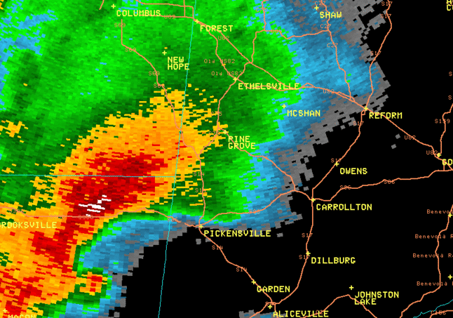
This is a loop of the reflectivity from KGWX from 1235 to 107 pm. Notice the "debris ball" while the storm is in Mississippi, but it goes away as it comes into Alabama.  This is indicative of a weakening storm.

Radar Loop
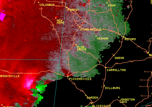
This is a loop of the SRM velocity from KGWX from 1235 to 
107 pm.  The rotation within this storm is extremly strong, indicated by the brighter colors that are side by side.  These brighter colors go away as the storm moves into Alabama.

 
Damage Pictures 

Storm Damage
Roof damage to a well-built home

Storm Damage
Significant tree damage

Storm Damage
Mobile home destroyed

Storm Damage
Roof removed from outbuilding

Tornado Image
Image of tornado in Pickens County