National Weather Service United States Department of Commerce


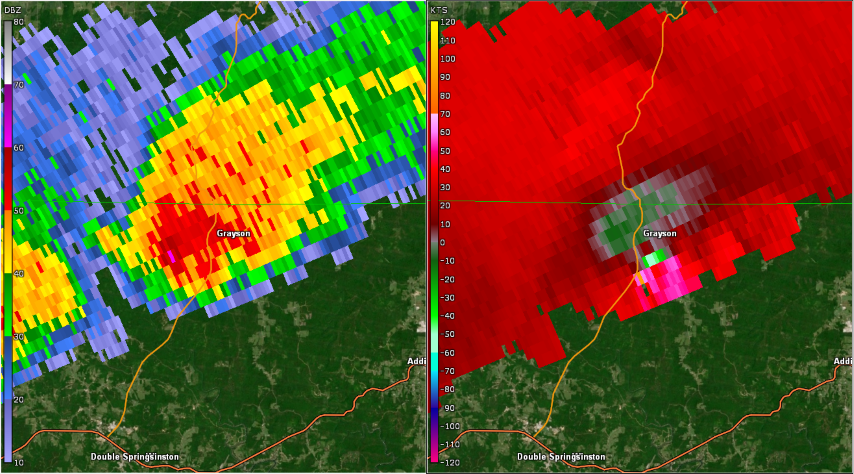
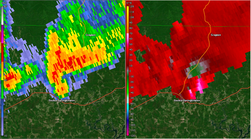
Remnants of Laura Produced Two Tornadoes on
August 28, 2020


On the afternoon of Aug 28 2020, the remnants of tropical system Laura moved eastward across the Tennessee and Ohio Valleys with a trailing surface boundary across portions of the Deep South. An abundance of tropical moisture coincided with areas of diurnal heating to promote an unstable atmosphere which also interacted with areas of favorable low-level and deep-layer wind shear. As a result, an environment favorable for the development of strong to severe thunderstorms established across a good portion of the Mid to Deep South, including Central Alabama. Strong to severe thunderstorms developed in the vicinity of southern Tennessee and northern Mississippi which tracked generally eastward during the mid afternoon, impacting various areas of northwest Central Alabama. Damaging straight-line winds produced several areas of tree damage as a line of thunderstorms moved across these areas. Additionally, two low-topped supercell thunderstorms moved ahead of this line and generally east-northeastward into Winston County in the late afternoon. These rotating thunderstorms were able to re-intensify and went on to produce two tornadoes, both of EF-1 strength, with the first near the Grayson and Moreland areas, and the second in the Double Springs area of north and central Winston County.


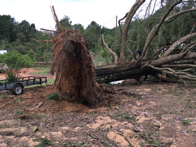
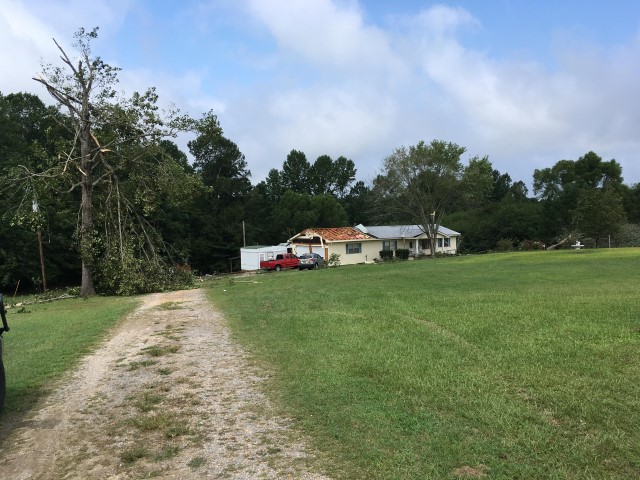
Moreland EF-1 Tornado (Winston County)


Event Summary

EF-1
Estimated Maximum Wind:
105 mph
Injuries/Fatalities:
None
Damage Path Length:
8.75 miles
Maximum Path Width:
325 yards
Approximate Start Point/Time:
3 SE Ashridge
34.2030/-87.4283
at 402 pm
Approximate End Point/Time:
2 NNE Moreland
34.2670/-87.2974
at 418 pm


NWS Meteorologists surveyed damage in northern Winston County and determined it was the result of a tornado.

The tornado developed in a wooded, uninhabited area east of County Road 195. The tornado moved northeast, crossing County Road 6 near Sandy Creek, where it caused minor timber damage. The tornado caused minor damage to the roof of a chicken house just off of County Road 415. The tornado continued northeast where it approached Highway 33 west of Moreland. The tornado caused notable timber damage as it crossed Highway 33, then it continued northeast across County Road 3163 where it removed sheathing from under a manufactured home, destroyed a small outbuilding, and removed portions of siding and sheathing from a manufactured home. The tornado then crossed County Road 63, or Cheatam Road, where it removed a portion of the roof from a manufactured home, damaged two garage doors, and blew out a window of a outdoor storage building. A small portion of this structure suffered some minor exterior wall relocation from the slab, but it was found that the wall was anchored by nailing to the concrete slab. The tornado continued northeast before dissipating in wooded, uninhabited terrain near Collier Creek.


Radar Image
Base Reflectivity (left) and Base Velocity (right)
depict the circulation just after the tornado touched down.
Images are from KGWX at 415 pm.


Damage Photo
  Tree Uprooted
Damage Photo
  Tree & Roof Damage


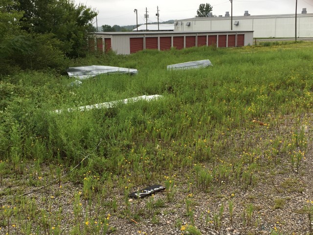
Double Springs EF-1 Tornado (Winston County)


Event Summary

EF-1
Estimated Maximum Wind:
95 mph
Injuries/Fatalities:
None
Damage Path Length:
2.56 miles
Maximum Path Width:
100 yards
Approximate Start Point/Time:
1 NNE Winston Free State Barn
34.1684/-87.4100
at 436 pm
Approximate End Point/Time:
2 NE Houston Recreational Area
34.1698/-87.3654
at 441 pm


NWS Meteorologists surveyed damage in northeastern Winston County and determined it was the result of a tornado.

The tornado developed near a mobile home manufacturing facility where it peeled portions of sheet metal from the roof of the building, removed some skirting from a modular building and blew out two windows on a vehicle. The tornado then crossed Highway 33 where it remained just north of County Road 24, north of the Winston County School complex and transportation lot. The tornado continued east through wooded, uninhabited and inaccessible area. The tornado was found to have dissipated before reaching County Road 2 where there was no observable damage. The National Weather Service would like to thank Winston County EMA for their assistance in these damage assessments.


Radar Image
Reflectivity (left) and velocity (right) of the tornado before it crossed Hwy 82.
Images are from KGWX at 438 pm.


Damage Photo
  Manufactured Building Skirting Damage
Damage Photo
  Metal Roofing Damage