National Weather Service United States Department of Commerce

Tennille (Pike) EF-1 Tornado
December 25th, 2012

 
EF-1
Estimated Maximum Wind:
110 mph
Injuries/Fatalities:
None
Damage Path Length:
3.66 miles
Maximum Path Width:
300 yards
Approximate Start Point/Time:
31.6180/-85.7709 at 530 pm
Approximate End Point/Time:
31.6664/-85.7473 at 536 pm
 

The tornado touched down in far northern Dale County along Highway 231 near the Pea River. The tornado tracked northeastward and crossed County Road (CR) 200 before it entered Pike County. The tornado continued northeastward and produced damage along CR 4425 and CR 4438. The tornado lifted near the intersection of CR 4427 north of CR 4421. Numerous trees were either snapped off or were uprooted along the damage path. The most significant damage occurred along CR 4425 where 2 homes sustained roof damage and 2 chicken houses were damaged. Also along CR 4438, a barn lost its roof with the tin being thrown over one half mile and hardwood trees were snapped and uprooted. The total tornado path length was 5.36 miles and was 300 yards wide at its widest point. The tornado first touched down at 527 pm CST.

Many thanks to the Pike and Dale County Sheriff departments for their assistance in conducting the surveys in Pike County.


Radar Data 

Radar Image
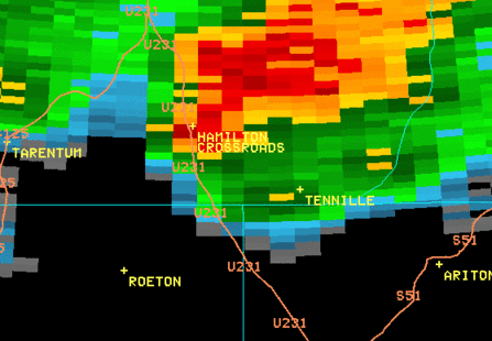
This is an image of the 0.5 degree reflectivity data from KMXX at 532 pm.  Notice the kidney bean shape to the thunderstorm.  This is indicative of a supercell thunderstorm.  Click to enlarge.

Radar Image
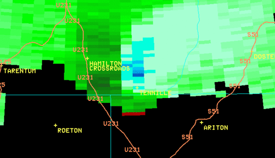
This is an image of the 0.5 degree SRM data from KMXX at 532 pm. The rotational couplet is not impressive, but at this distance from the radar, you are seeing the mesocyclone.  Click to enlarge.

 
Damage Pictures 

Damage
Aerial view of damage to home and barn
from the north

Damage
Aerial view of damage to home and barn
from the west

Damage
Carport damage

Damage
Minor roof damage