Alabama Tornado Database
|
| 1998 Tornado Occurrences (50) |
| Tornado # of Year |
Year |
Month |
Day |
Time (CST) |
County |
Damage Scale |
Path Length (Miles) |
Maximum Path Width (Yards) |
Fatalities |
Injuries |
Location |
| 50 |
1998 |
9 |
29 |
0145 |
Geneva
Hurricane Georges
Hurricane Georges Report
More Georges Information
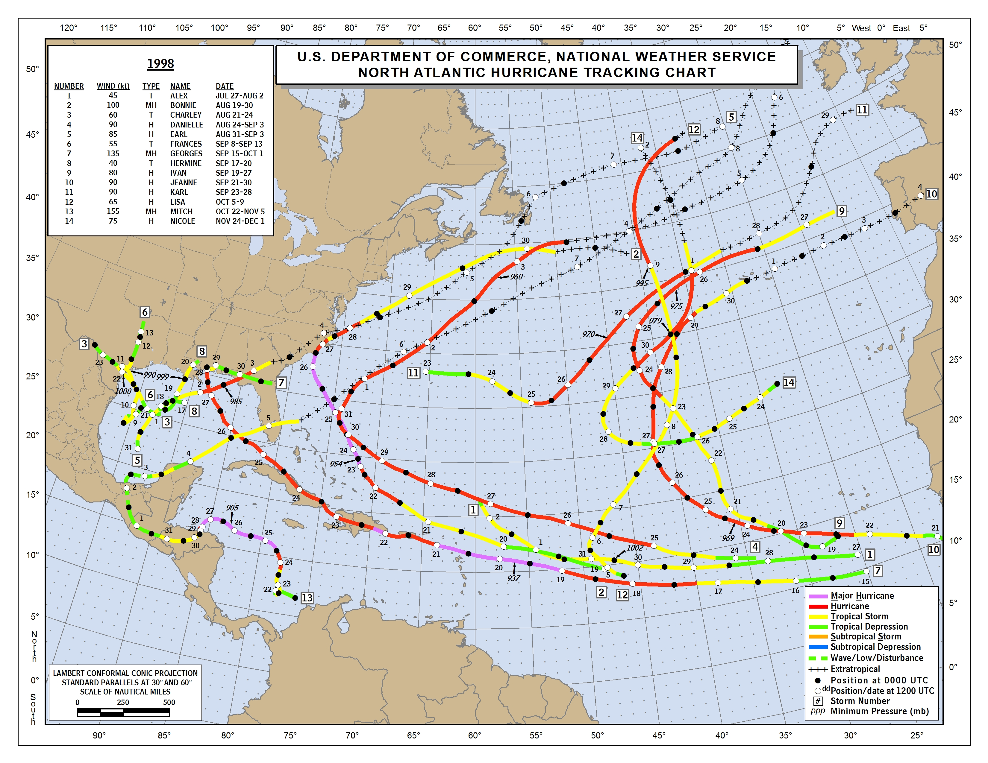
1998 Tropical Map |
F1 |
3.0 |
50 |
0 |
0 |
4 NNE Geneva - 7 NNE Geneva
An F1 tornado skipped along AL 85 between Geneva and Bellwood. Several trees and power lines were toppled and the Providence Church near Bellwood sustained minor roof damage.
Start: 31.0900/-85.8500
End: 31.1300/-85.8300
|
| 49 |
1998 |
9 |
29 |
0145 |
Coffee
Hurricane Georges
Hurricane Georges Report
More Georges Information
1998 Tropical Map |
F1 |
1.0 |
50 |
0 |
0 |
New Brockton
An F1 tornado descended near CR 732 in New Brockton damaging several chicken houses, roads, ditches, and drainage systems.
Start: 31.3800/-85.9300
End: 31.3800/-85.9300
|
| 48 |
1998 |
9 |
29 |
0140 |
Coffee
Hurricane Georges
Hurricane Georges Report
More Georges Information
1998 Tropical Map |
F1 |
1.0 |
80 |
0 |
0 |
Enterprise
An F1 tornado touched down on CR 725 near Enterprise. One residence suffered roof damage. Camp Wiregrass sustained moderate to severe damage with several buildings crumpled, trees and power lines down, and scattered debris. Numerous customers in Enterprise were without electric service. A semi was blown over at Con Agra.
Start: 31.3200/-85.8500
End: 31.3200/-85.8500
|
| 47 |
1998 |
9 |
29 |
0130 |
Geneva
Hurricane Georges
Hurricane Georges Report
More Georges Information
1998 Tropical Map |
F1 |
1.0 |
60 |
0 |
3 |
Samson
An F1 tornado touched down five miles northeast of Samson off CR 8. One mobile was lifted 50 feet off its foundation and destroyed. The three occupants sustained minor injuries.
Start: 31.1200/-86.0500
End: 31.1200/-86.0500
|
| 46 |
1998 |
9 |
28 |
1935 |
Dale
Hurricane Georges
Hurricane Georges Report
More Georges Information
1998 Tropical Map |
F0 |
0.3 |
40 |
0 |
0 |
Echo
An F0 tornado briefly touched down at the intersection of CR 40 and 7 near the Dale Henry County Line. Numerous trees were uprooted and a pump house was destroyed.
Start: 31.4800/-85.4700
End: 31.4800/-85.4700
|
| 45 |
1998 |
9 |
28 |
1900 |
Henry
Hurricane Georges
Hurricane Georges Report
More Georges Information
1998 Tropical Map |
F0 |
0.5 |
40 |
0 |
0 |
Newville
An F0 tornado damaged a barn and residence off CR 173 in Newville.
Start: 31.4200/-85.3300
End: 31.4200/-85.3300
|
| 44 |
1998 |
9 |
28 |
1626 |
Russell-Lee
Hurricane Georges
Hurricane Georges Report
More Georges Information
1998 Tropical Map |
F0 |
2.0 |
30 |
0 |
0 |
12.0 W Phenix City-3.8 SE JC Meadows Crossroads
Brief touchdown near Crawford with little to no damage. Remnants of tropical system.
Start: 32.4600/-85.2000
End: 32.4800/-85.1800
|
| 43 |
1998 |
9 |
28 |
1619 |
Elmore
Hurricane Georges
Hurricane Georges Report
More Georges Information
1998 Tropical Map |
F0 |
3.0 |
50 |
0 |
0 |
2.2 NE Wetumpka-3.5 N Wetumpka
Trees downed in Wallsboro and damage to prison facility. Remnants of tropical system.
Start: 32.5700/-86.1800
End: 32.6000/-86.2200
|
| 42 |
1998 |
9 |
28 |
1444 |
Bullock
Hurricane Georges
Hurricane Georges Report
More Georges Information
1998 Tropical Map |
F0 |
4.0 |
40 |
0 |
0 |
5.9 S Union Springs-3.3 S Union Springs
A few trees downed and minor damage. Remnants of tropical system.
Start: 32.0600/-85.7100
End: 32.1000/-85.7200
|
| 41 |
1998 |
9 |
28 |
1430 |
Dale
Hurricane Georges
Hurricane Georges Report
More Georges Information
1998 Tropical Map |
F0 |
0.3 |
30 |
0 |
0 |
Ozark
An F0 tornado briefly touched down on the north side of Ozark off Marvin Parker Road and CR 68 uprooting trees and power poles.
Start: 31.4500/-85.6500
End: 31.4500/-85.6500
|
| 40 |
1998 |
9 |
28 |
1353 |
Bullock
Hurricane Georges
Hurricane Georges Report
More Georges Information
1998 Tropical Map |
F0 |
7.0 |
70 |
0 |
0 |
11.1 SSW Union Springs-10 SW Union Springs
Several trees downed, minor structure damage, and one church totally destroyed. Remnants of tropical system.
Start: 31.9900/-85.7700
End: 32.0600/-85.8600
|
| 39 |
1998 |
9 |
28 |
1347 |
Lowndes
Hurricane Georges
Hurricane Georges Report
More Georges Information
1998 Tropical Map |
F0 |
6.0 |
50 |
0 |
0 |
Letohatchee-0.9 S Hayneville
Numerous trees downed, one mobile home destroyed, and minor damage to several structures. Remnants of tropical system.
Start: 32.1300/-86.5000
End: 32.1700/-86.5800
|
| 38 |
1998 |
9 |
28 |
1318 |
Pike
Hurricane Georges
Hurricane Georges Report
More Georges Information
1998 Tropical Map |
F0 |
6.0 |
50 |
0 |
0 |
14.0 ESE Troy-12.3 E Troy
Trees downed near Monticello and Shiloh. Remnants of tropical system.
Start: 31.7200/-85.7500
End: 31.8000/-85.7500
|
| 37 |
1998 |
9 |
28 |
1310 |
Crenshaw
Hurricane Georges
More Georges Information
Hurricane Georges Report
1998 Tropical Map |
F1 |
0.5 |
50 |
0 |
0 |
Petrey
A tornado briefly touched down near the community of Petrey. Three homes suffered major damage. Trees and power lines were also blown down. No injuries were reported.
Start: 31.8500/-86.2000
End: 31.8500/-86.2000
|
| 36 |
1998 |
9 |
28 |
1310 |
Crenshaw
Hurricane Georges
More Georges Information
Hurricane Georges Report
1998 Tropical Map |
F1 |
0.5 |
50 |
0 |
0 |
Luverne
A tornado briefly touched down just northwest of Luverne. The tornado destroyed a county barn and caused minor damage to several brick homes. Trees and power lines were also blown down.
Start: 31.7200/-86.2600
End: 31.7200/-86.2700
|
| 35 |
1998 |
9 |
28 |
1306 |
Pike
Hurricane Georges
Hurricane Georges Report
More Georges Information
1998 Tropical Map |
F0 |
5.0 |
50 |
0 |
0 |
17.0 SE Troy-12.0 SE Troy
Trees downed near Hamiltons Crossroads. Remnants of tropical system.
Start: 31.6300/-85.7700
End: 31.6800/-85.8200
|
| 34 |
1998 |
9 |
28 |
1305 |
Crenshaw
Hurricane Georges
Hurricane Georges Report
More Georges Information
1998 Tropical Map |
F1 |
0.5 |
50 |
0 |
0 |
Patsburg
A tornado briefly touched down near the community of Patsburg. Two homes had major damage and a business was destroyed. Trees and power lines were also blown down. Several horses were also injured.
Start: 31.7800/-86.2300
End: 31.7800/-86.2300
|
| 33 |
1998 |
9 |
28 |
1257 |
Crenshaw-Pike
Hurricane Georges
Hurricane Georges Report
More Georges Information
1998 Tropical Map |
F1 |
2.6 |
30 |
0 |
0 |
16.0 SW Troy-15.9 SW Troy
Numerous trees and power lines downed near Camp Sharon and Fleetwood. Remnants of tropical system.
Start: 31.6300/-86.1700
End: 31.6700/-86.1700
|
| 32 |
1998 |
9 |
28 |
0745 |
Covington
Hurricane Georges
Hurricane Georges Report
More Georges Information
1998 Tropical Map |
F0 |
0.5 |
50 |
0 |
0 |
5 NE Andalusia
A tornado briefly touched down near the community of Antioch (northeast of Andalusia). The tornado caused roof damage to three homes. Several trees and power lines were also blown down.
Start: 31.3500/-86.4200
End: 31.3500/-86.4200
|
| 31 |
1998 |
9 |
28 |
0705 |
Covington
Hurricane Georges
Hurricane Georges Report
More Georges Information
1998 Tropical Map |
F0 |
0.2 |
50 |
0 |
0 |
4 SW Opp
A tornado briefly touched down along County Road 77, about 4 miles southwest of Opp. The tornado twisted several trees and power lines down.
Start: 31.2500/-86.3000
End: 31.2500/-86.3000
|
| 30 |
1998 |
9 |
27 |
1655 |
Baldwin
Hurricane Georges
Information
Hurricane Georges Report
More Georges Information
1998 Tropical Map |
F0 |
0.1 |
30 |
0 |
0 |
3 N Loxley
A tornado briefly touched down just north of Interstate 10 near the Loxley exit. The only damage was to trees and power lines.
Start: 30.6700/-87.7500
End: 30.6700/-87.7500
|
| 29 |
1998 |
9 |
19 |
1300 |
Baldwin |
F0 |
0.1 |
30 |
0 |
0 |
Gulf Shores
A waterspout moved ashore near Gulf Shores and rapidly dissipated. No damage was found.
Start: 30.2800/-87.6800
End: 30.2800/-87.6800
|
| 28 |
1998 |
6 |
23 |
1400 |
Geneva |
F1 |
2.5 |
30 |
0 |
0 |
4 SW Slocumb-6 S Slocumb
Just east of CR 9 about 3.5 miles north of Slocomb, sheet metal off a hay barn was blown 1/4 mile to the ENE. One neighboring property sustained tree and roof damage, a destroyed shed and a damaged hay barn. One nearby mobile home lost its roof with tree limb damage within a one mile radius. Dime sized hail accompanied the storm. South of Slocomb, damage was more severe. Spotty tree damage began about 2 miles south along CR 85. The most danage occurred 1/4 mile east of the New Teamon Baptist Church. Several large oak trees were uprooted, extensive tree limb damage, a mobile home roof damaged, and a barn sustained roof and door damage. Two structures on CR 91 were damaged by fallen trees. One witness observed the tornado as 100 yards wide, moving from NW to SE. Hail fell prior to the tornado passage.
Start: 31.0500/-85.6100
End: 31.0200/-85.5900
|
| 27 |
1998 |
5 |
9 |
1820 |
Pickens-Tuscaloosa |
F0 |
6.5 |
70 |
0 |
0 |
1.4 S Gordo-2.3 NE Holman
Downed trees and minor structure damage.
Start: 33.3000/-87.9000
End: 33.3000/-87.8000
|
| 26 |
1998 |
5 |
9 |
1809 |
Pickens |
F0 |
2.2 |
50 |
0 |
0 |
1.7 NW Carrollton-1.2 NNE Carrollton
Several trees downed and minor damage to a hospital.
Start: 33.2800/-88.1200
End: 33.2800/-88.1000
|
| 25 |
1998 |
5 |
7 |
0527 |
Madison |
F1 |
2.0 |
80 |
0 |
0 |
New Market
Trees were down in the New Market area, this damaged several homes in the area. One home had major damage and four homes had minor roof damage.
Start: 34.9100/-86.4500
End: 34.9100/-86.4100
|
| 24 |
1998 |
5 |
7 |
0503 |
Madison |
F1 |
1.5 |
50 |
0 |
0 |
Toney
Six homes were damaged in the Toney Community, in northern Madison County. One home had major damage, one had moderate damage and four had minor damage.
Start: 34.9000/-86.7500
End: 34.9000/-86.7200
|
| 23 |
1998 |
5 |
4 |
0028 |
Houston |
F0 |
0.2 |
30 |
0 |
0 |
Ashford
Tornado spotted by public three miles east of Ashford.
Start: 31.1800/-85.2300
End: 31.1800/-85.2300
|
| 22 |
1998 |
5 |
3 |
1630 |
Coffee |
F0 |
0.3 |
30 |
0 |
0 |
New Brockton
Tornado downed trees and power lines at intersection of State Highways 233 and 167 near New Brockton. A funnel cloud was sighted earlier near Elba.
Start: 31.3800/-85.9300
End: 31.3800/-85.9300
|
| 21 |
1998 |
4 |
18 |
1745 |
Dallas |
F0 |
0.2 |
30 |
0 |
0 |
Marion Junction
Brief touchdown with little or no damage.
Start: 32.4300/-87.2300
End: 32.4300/-87.2300
|
| 20 |
1998 |
4 |
18 |
1724 |
Chilton |
F0 |
1.0 |
30 |
0 |
0 |
3.4 SE Maplesville - 4.4 SE Maplesville
Little to no damage reported.
Start: 32.7500/-86.8300
End: 32.7300/-86.8300
|
| 19 |
1998 |
4 |
18 |
1558 |
Calhoun |
F1 |
4.2 |
80 |
0 |
0 |
5.3 W Oxford-3.7 NW Oxford
Wellborn High School and Elementary School were heavily damaged. A church was also damaged.
Start: 33.5800/-85.9800
End: 33.6200/-85.9300
|
| 18 |
1998 |
4 |
17 |
1615 |
Covington |
F1 |
1.0 |
300 |
0 |
0 |
Opp
A tornado touched down just east of the Opp Country Club, then moved southeast crossing U S Highway 84 just south of downtown before lifting back into the cloud just west of U S Highway 331. The tornado damaged the Opp Mill and tore off part of the roof from the South Highlands Elementary School. The tornado damaged more than ninety homes and several businesses. No injuries were reported.
Start: 31.2800/-86.2500
End: 31.2800/-86.2500
|
| 17 |
1998 |
4 |
16 |
2135 |
Cherokee |
F0 |
1.3 |
80 |
0 |
0 |
0.3 S Centre-1.3 E Centre
Several trees downed and minor roof damage.
Start: 34.1500/-85.6800
End: 34.1500/-85.6700
|
| 16 |
1998 |
4 |
16 |
2101 |
Etowah |
F1 |
3.1 |
100 |
0 |
0 |
2.2 SW Reece City-0.6 N Reece City
Hundreds of trees downed and some fell on houses.
Start: 34.0500/-86.0700
End: 34.0800/-86.0300
|
| 15 |
1998 |
4 |
16 |
2046 |
Etowah |
F1 |
8.4 |
150 |
0 |
0 |
1.5 W Gallant - 1.8 W Attalla
Numerous trees downed and some structure damage.
Start: 34.0000/-86.2700
End: 34.0200/-86.1200
|
| 14 |
1998 |
4 |
16 |
2035 |
Blount |
F0 |
2.1 |
80 |
0 |
0 |
6.0 NE Oneonta-8.1 NE Oneonta
Several trees downed and some on houses. Several cows killed.
Start: 34.0200/-86.4000
End: 34.0300/-86.3700
|
| 13 |
1998 |
4 |
16 |
2015 |
Blount-Cullman |
F1 |
3.7 |
100 |
0 |
0 |
2.5 NNE Bangor-3.7 NE Bangor
Numerous trees down and some structure damage.
Start: 34.0000/-86.7700
End: 34.0000/-86.7200
|
| 12 |
1998 |
4 |
16 |
2004 |
Cullman |
F1 |
5.8 |
90 |
0 |
0 |
1.9 NE Arkadelphia - 0.5 NE Damascus
A tornado touched down just north of Arkadelphia and SR 91 and traveled northeastward moving across the northern side of The Colony Community. It crossed Interstate 65 at the 294-mile marker before ending. The tornado damaged a number of houses and outbuildings and downed numerous trees.
Start: 33.9300/-86.9500
End: 33.9800/-86.8700
|
| 11 |
1998 |
4 |
16 |
1957 |
Cullman |
F0 |
4.0 |
80 |
0 |
0 |
4 WNW Arkadelphia - Wilburn- 1.4 NW Arkadelphia
A small tornado touched down in extreme southwestern Cullman County. A few structures were damaged along with numerous trees downed or uprooted.
Start: 33.9200/-87.0300
End: 33.9200/-86.9800
|
| 10 |
1998 |
4 |
16 |
1946 |
Walker-Cullman |
F1 |
5.5 |
110 |
0 |
0 |
6.5 NW Sipsey-5.2 N Sipsey
3 mobile homes destroyed and several damaged. One house damaged and numerous trees downed.
Start: 33.8800/-87.1700
End: 33.9000/-87.0700
|
| 9 |
1998 |
4 |
16 |
1936 |
Walker |
F0 |
4.6 |
100 |
0 |
0 |
2.6 NNW Jasper-4.6 NE Jasper
Several trees and power lines downed. A few mobile homes damaged.
Start: 33.8700/-87.3000
End: 33.8800/-87.2300
|
| 8 |
1998 |
4 |
16 |
1929 |
Walker |
F0 |
1.8 |
50 |
0 |
0 |
0.9 WNW Townley-1.3 NE Townley
Several trees downed.
Start: 33.8300/-87.4500
End: 33.8500/-87.4200
|
| 7 |
1998 |
4 |
16 |
1825 |
Lamar |
F1 |
4.9 |
80 |
0 |
0 |
4.9 WSW Hightogy-Hightogy
Several trees downed and outbuildings damaged.
Start: 33.6700/-88.1800
End: 33.7000/-88.1000
|
| 6 |
1998 |
4 |
8 |
1956 |
St. Clair
Storm Survey
Service Assessment |
F2 |
14.4 |
200 |
2 |
12 |
2.3 NNE Moody-3.2 SE Wattsville
26 homes destroyed, 30 with major damage, 59 with minor damage. 2 fatalities occurred in a mobile home.
Start: 33.6202/-86.4715
End: 33.6640/-86.2290
|
| 5 |
1998 |
4 |
8 |
1923 |
Dekalb
Storm Survey
Service Assessment |
F1 |
1.8 |
100 |
0 |
0 |
1 S Lake View - 1 NE Lake View
A small tornado destroyed a few barns near Geraldine. Numerous trees were also snapped or uprooted.
Start: 34.3800/-85.9800
End: 34.4000/-85.9700
|
| 4 |
1998 |
4 |
8 |
1842 |
Tuscaloosa-Jefferson
Storm Survey
Service Assessment
News Report |
F5 |
30.3 |
1320 |
32 |
259 |
10.0 NNW Brookwood-Pratt City
Tremendous damage along the path.
Start: 33.4200/-87.3500
End: 33.5800/-86.8700
|
| 3 |
1998 |
4 |
8 |
1801 |
Pickens-Tuscaloosa
Storm Survey
Service Assessment |
F3 |
19.5 |
300 |
0 |
1 |
2.0 S Gordo-7.6 N Northport
5 homes destroyed and 24 others damaged. 11 mobile homes destroyed and several damaged.
Start: 33.2800/-87.9000
End: 33.3300/-87.5800
|
| 2 |
1998 |
4 |
08 |
0920 |
Covington
Service Assessment |
F1 |
0.1 |
30 |
0 |
0 |
Heath
A tornado briefly touched down along U S Highway 29 near Heath. A roof was torn off of four rooms at a motel along the highway. The tornado, only on the ground for a short period of time, knocked a couple of trees down and caused minor damage to a mobile home across the highway from the motel. No injuries were reported.
Start: 31.3500/-86.4700
End: 31.3500/-86.4700
|
| 1 |
1998 |
2 |
22 |
0800 |
Houston |
F0 |
0.3 |
50 |
0 |
0 |
Taylor
52 homes in Landview Subdivision sustained wind damage to shingles, fences, awnings, storage sheds, and porches. Some trees and power lines down. Several public sightings of a funnel cloud.
Start: 31.1700/-85.4700
End: 31.1700/-85.4700
|

