
Heat expands across the Desert Southwest, Plains, Mississippi Valley and Midwest into Monday. Fire weather concerns continue for portions of the Intermountain West. Active monsoonal moisture fuels thunderstorms over the Southwest with possible flash flooding. Tropical cyclone Fausto in the Pacific, should weaken as it approaches Hawaii; Dangerous surf, swells and rip currents are expected. Read More >
Overview
|
On Saturday June 6 much of Colorado experienced strong thunderstorm winds associated with a long-lived line of severe thunderstorms known as a derecho (pronounced deh-REY-cho). The derecho formed over eastern Utah in late morning, and moved across the mountains and the eastern plains in the afternoon and early evening. It went on to produce damaging wind all the way into the Dakotas and far northwest Minnesota by the morning of Sunday June 7. Earlier in the day and prior to the arrival of the storms, strong winds on the Colorado plains were clocked at 50 to 70 mph. |
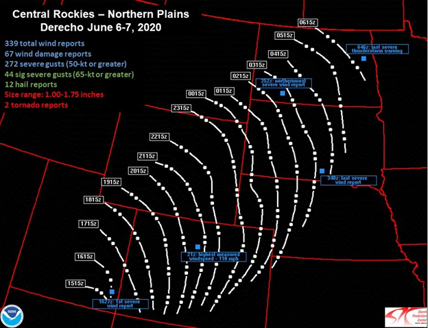 Path of the June 6-7 Derecho. Image source: NOAA/NWS Storm Prediction Center |
Wind:
The combination of an upper level trough moving across Colorado, along with a strong level pressure gradient, led to numerous reports of strong winds across much of the area on Saturday. Strong wind gusts from 55 to 70 mph, not associated with thunderstorms, occurred over the plains of northeast Colorado during the day of June 6 prior to the arrival of the line of thunderstorms.
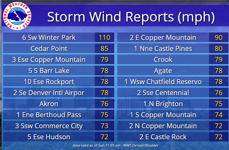
Meanwhile, thunderstorms that developed over eastern Utah moved over the higher terrain of Colorado by mid day, and then moved rapidly northeast across the I-25 corridor by afternoon. These storms then tracked across the plains from late afternoon into the early evening hours. Wind gusts from 60 to 80 mph were common with a few gusts exceeding 90 mph. The highest gust observed was 110 mph, at the Winter Park Ski area, around 12000 feet.
 |
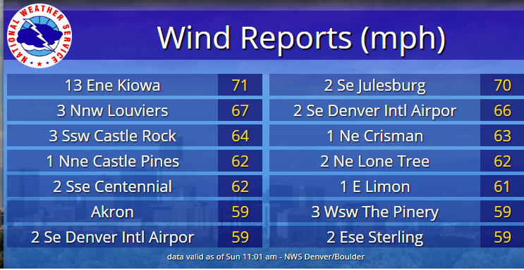 |
| Thunderstorm Wind Gusts 06/06/2020 | Non-Thunderstorm Wind Gusts 06/06/2020 |
Photos & Video
 |
 |
 |
 |
| Billboard snapped off at 1898 S Broadway Denver (CBS-Denver) |
Downed tree at Presbyterian/St Lukes Hospital 21st & Franklin, Denver (Minh Phan) |
Tree down on house near Sheridan & Lehigh, Denver (Ann Griffin) |
Tree snapped off & blown into street near Sheridan & Lehigh, Denver (Ann Griffin) |
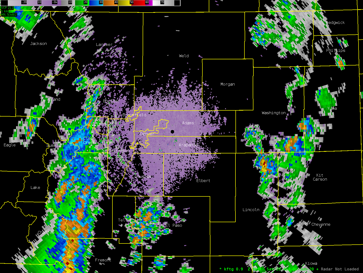
Radar
 |
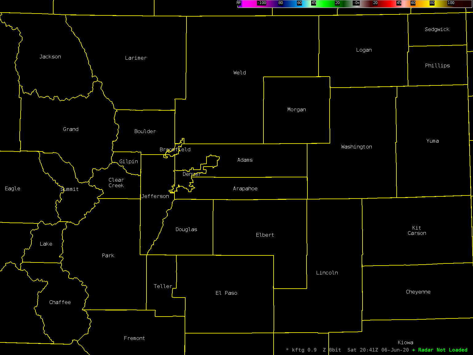 |
| Radar animation of Base Reflectivity KFTG 06/06/2020 |
Radar animation of Base Velocity KFTG 06/06/2020 |
Environment
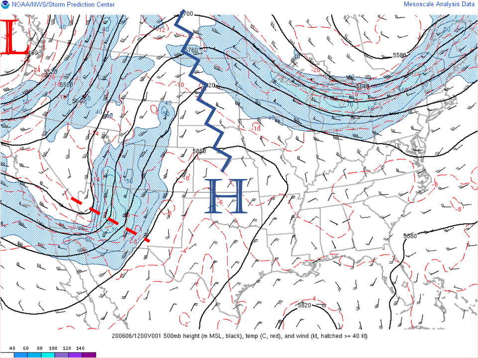
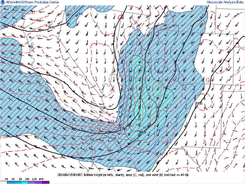
At 6 AM MDT at the 500 mb level, roughly 20,000 ft altitude, the upper air pattern was a large trough of low pressure extending from a low pressure area off the Pacific coast of the NW US, south across the western US. A ridge of high pressure dominated the central US, guiding jet stream winds from the southwest to northeast across the Rockies. A short-wave trough was embedded in the southwest flow, and would be the focus for strong winds and severe weather as it crossed Colorado during the day Saturday. (Figure 1)
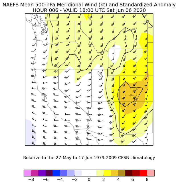
Wind speeds associated with the short wave trough were from 60 to over 80 knots at 500 mb, which were 3 to 4 Standard Deviations higher than normal (Figure 2). Even at 700 mb, roughly 10,000 ft altitude, wind speeds of 30 to 40 knots were 5 to 6 Standard Deviations above normal (Figure 3).
 |
 |
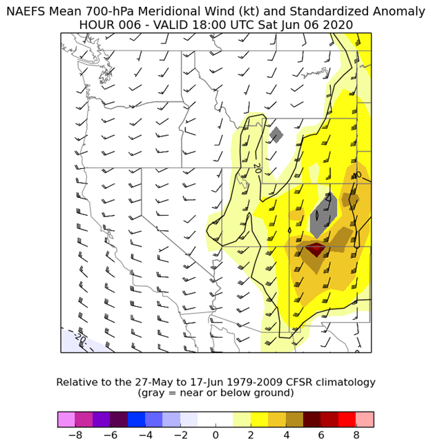 |
| Figure 1: 500 mb Analysis valid 1200 UTC 06/06/2020 | Figure 2: 500 mb Wind Speed Anomalies valid 1800 UTC 06/06/2020. Orange/Brown indicate 3-5 Standard Deviations above normal. | Figure 3: 700 mb Wind Speed Anomalies valid 1800 UTC 06/06/2020. Orange/Brown indicate 3-5 Standard Deviations above normal. |
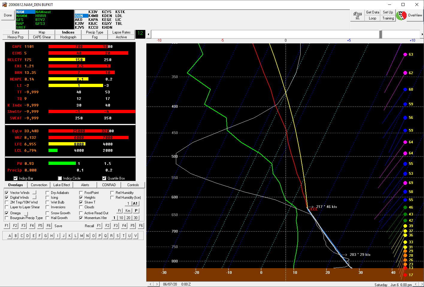
The shortwave trough and 500 MB wind maximum moved across Colorado during the day, sustaining the line of thunderstorms and increasing the potential for strong gusty winds (Figure 4). Model soundings showed a moderately unstable atmosphere that would become well mixed to the 650 to 600 mb levels later in the day, aiding in momentum transfer of the mid level jet to the surface (FIgure 5).
Eastern Utah and western Colorado were placed in a Slight Risk for severe thunderstorm development by the Storm Prediction Center (Figure 6). SPC noted the upward motion forced by the upper level trough and increasing mid-level wind speeds, and the potential for organized bands of thunderstorm and severe thunderstorm wind gusts of 60 to 85 mph. SPC went on to issue Severe Thunderstorm Watch 260 at 950 AM MDT for eastern Utah, western Colorado, and a small portion of southwest Wyoming. Severe Thunderstorm Watch 262 was issued for the afternoon and evening for central and eastern Colorado.
 |
 |
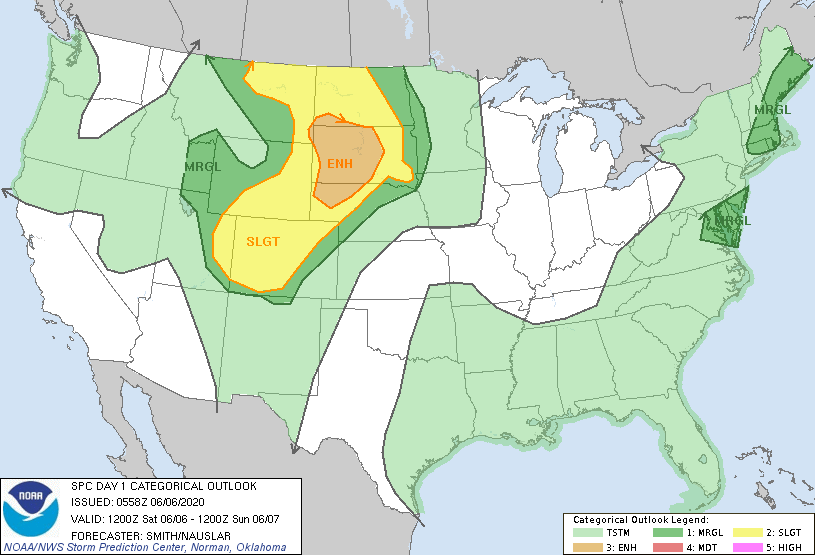 |
| Figure 4: 500 mb Height and Wind animation 1200 UTC 06/06/2020 - 0300 utc 06/07/2020 | Figure 5: 12 hour NAM forecast sounding valid 0000 UTC 06/07/2020 | Figure 6: SPC Day 1 Outlook issued 0558 UTC 06/06/2020 |
Storms developed across southeast Utah and moved into western Colorado by mid day, and across central and eastern Colorado through the afternoon and evening. South wind intensified ahead of the storms along the foothills and east onto the plains, with non-thunderstorm winds of 50 to 70 mph recorded.
 |
Media use of NWS Web News Stories is encouraged! Please acknowledge the NWS as the source of any news information accessed from this site. |
|

