
Scattered strong to severe thunderstorms may pose a risk for damaging wind gusts over the Carolinas, southeast Virginia, and the Tennessee Valley Sunday afternoon then the northern Plains from late afternoon into Sunday night. Monsoonal thunderstorms may cause locally considerable flash, urban, and small stream flooding in the Southwest U.S. the next few days. Read More >
Denver began 2019 under the influence of weak El Nino conditions which began in the fall of 2018 and persisted through the summer of 2019. This weak El Nino episode gradually transitioned into a ENSO neutral environment (EL Nino - Southern Oscillation) in the summer 2019 and is currently the environment the northern hemisphere finds itself in as we start 2020. In general, El Nino conditions bring wetter than normal conditions to the Front Range and eastern Plains of Colorado, primarily in the spring and winter months. When in La Nina environments, near to below average precipitation is often experienced along the Front Range and high plains region east of the Rockies. ENSO neutral environments, along with the transition into neutral and out of neutral, have also been known to occasionally bring dry and wet seasonal extremes to the Rocky Mountain region.
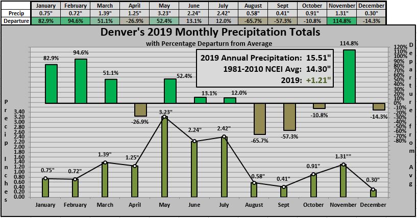
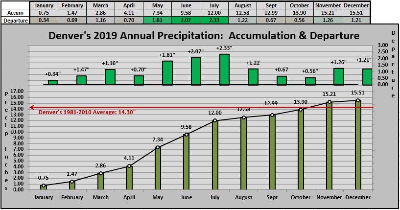
For the weather parameters of precipitation and temperature, 2019 finished wetter and cooler than average. After 3 years of below average precipitation, Denver wrapped up 2019 with an above average total of 15.51" inches. This is 1.21" above the normal of 14.30 inches (NCEI 1981-2010). The previous year of 2018 ending with a scant 8.53 inches. As for temperatures, 2019 was the first year since 2013 where the year finished below the annual average. The average annual temperature in Denver for 2019 was 49.6°F, which was 0.9°F below the 148 year average of 50.5°F. This is 0.8°F below the current NCEI 1981-2010 average 50.4°F.
Precipitation:
Temperatures:
Across the high plains east of the Rockies, wet conditions often coincide with below average temperatures. This was certainly the case in the winter and spring months of 2019. Most notable were the months of February, March, May along with October later in the year. Both May and October landed in the "Top 10 Coldest Months" category. As two strong and cold storm systems arrived in May, widespread precipitation and snowfall was brought to the foothills and Front Range, the month came in 7th coldest in Denver's 148 year history with a cool monthly average of 51.6°F. Later in the year, in typical mountain-west fashion, a strong and sharp pattern change brought two Top 10 average monthly temperatures for both September and October on opposite ends of the temperature spectrum. After September's 2nd warmest month in Denver History, and Arctic blast hit the final week of October taking that month to the 4th Coldest in Denver's 148 year history. September ended the month with a warm 69.3°F average with October taking it the opposite extreme ending with a cold 43.7°F average.
.JPG)
Snowfall:
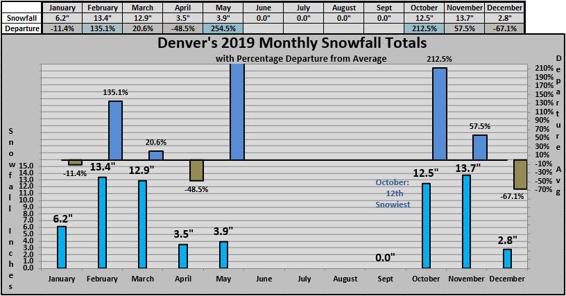
The cold and active start to the 2019 brought mostly evenly spaced storm system to northern Colorado in January and February. Three strong storm systems brought snowfall to Denver in the short month of February alone which allowed the month to experience 135% above average snowfall. With March climatologically known as the snowiest month in the Mile High City, March certainly did not disappoint the snow and winter lovers. The month came in 21% above average, however what was most notable was an extremely strong and historic storm system which brought widespread blizzard conditions to northeastern Colorado. The storm did not bring excessive snowfall to the Front Range, however the winds associated with the deep closed low was one for the record books as persistent 60-80 mph northerly winds hit the eastern side of the Mile High City pounding northern and eastern Colorado with white-out conditions. With two cold and active months of February and March combined with additional snowfall arriving in April in May, the following early snowfall season of 2019-20 followed through with the cold and moist theme. Arctic cold, along with good snowfall, arrived in last week of October. This cold event, paired with the moist and snowy pre-Thanksgiving November storm, brought additional water to the South Platte Drainage Basin. In the final month of 2019, as it was looking like a record or near record lack of snowfall for December, another late month storm system brought the final snowfall for 2019 as Denver ended the final month with 2.8 inches.
When 2019 ended, the average annual temperature for Denver finalized at 49.6°F, which is 0.8°F below the NCEI 1981-2010 annual average of 50.4°F. For the full 148 year record, 2019 was 0.9°F below the average of 50.5°F. This tied for 38th coldest in Denver`s 148 Year temperature history along with 1965, 1964, 1962 and 1886. The coldest year in Denver`s weather History was in 1912 with an average annual temperature of 47.6°F. The warmest year was 1934 with an annual average of 54.8°F.
Denver's 148 year history of Average Annual Temperatures & Precipitation from 1872 through 2019
.JPG)

