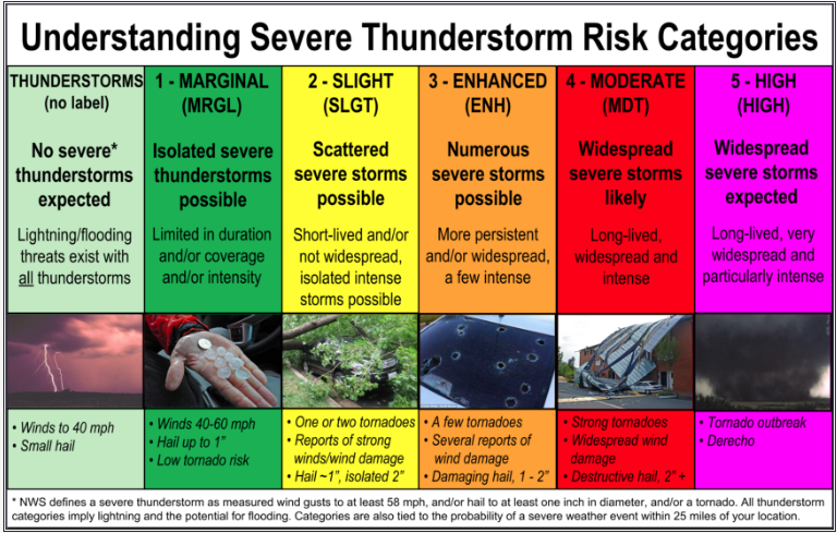
Today's Tornado Potential
|
Risk Level
|
Definition
|
|
|
|
None
|
No tornado risk.
|
|
|
Marginal
|
Probability of a tornado within 25 miles of a point:
2 percent. |
|
|
Slight
|
Probability of a tornado within 25 miles of a point:
5 percent. |
|
|
Enhanced
|
Probability of a tornado within 25 miles of a point:
Equal to or greater than 10 percent. |
|
|
Moderate
|
Probability of a tornado within 25 miles of a point:
Equal to or greater than 30 percent. |
|
|
High
|
Probability of a tornado within 25 miles of a point:
Equal to or greater than 45 percent. |
|
|
Extreme
|
Probability of a tornado within 25 miles of a point:
Equal to or greater than 60 percent. |
Today's Hail Potential
Hail Risk Legend Severe Thunderstorm Safety Tips
|
Risk Level
|
Definition
|
|
| None | No Risk of Hail | |
|
|
Marginal
|
Risk of sub-severe hail (less than 1") or
Probability of severe hail (1" or greater) within 25 miles of a point: less than 15% |
|
|
Slight
|
Probability of severe hail (1" or greater) within 25 miles of a point:
Equal to or than 15% |
|
|
Enhanced
|
Probability of severe hail (1" or greater) within 25 miles of a point:
Equal to or greater than 30% |
|
|
Moderate
|
Probability of severe hail (1" or greater) within 25 miles of a point:
Equal to or greater than 45% |
|
|
High
|
Probability of severe hail (1" or greater) within 25 miles of a point: Equal to or greater than 60%
Probability of severe hail (2" or greater) within 25 miles of a point: Equal to or greater than 10% |
Today's Thunderstorm Wind Potential
|
Risk Level
|
Definition
|
|
| None | No Thunderstorm Wind Risk. | |
|
|
Marginal
|
Risk of sub-severe wind gusts (less than 58 mph) or
Probability of severe wind gusts (58 mph or greater) within 25 miles of a point: Equal to or less than 5% |
|
|
Slight
|
Probability of severe winds gusts (58 mph or greater) within 25 miles of a point:
Equal to or greater than 15% |
|
|
Enhanced
|
Probability of severe wind gusts (58 mph or greater) within 25 miles of a point:
Equal to or greater than 30% |
|
|
Moderate
|
Probability of severe wind gusts (58 mph or greater) within 25 miles of a point:
Equal to Greater than 45% |
|
|
High
|
Probability of severe wind gusts (58 mph or greater) within 25 miles of a point: Equal to or Greater than 60%
Probability of severe wind gusts (75 mph or greater) within 25 miles of a point: Equal to or Greater than 10% |
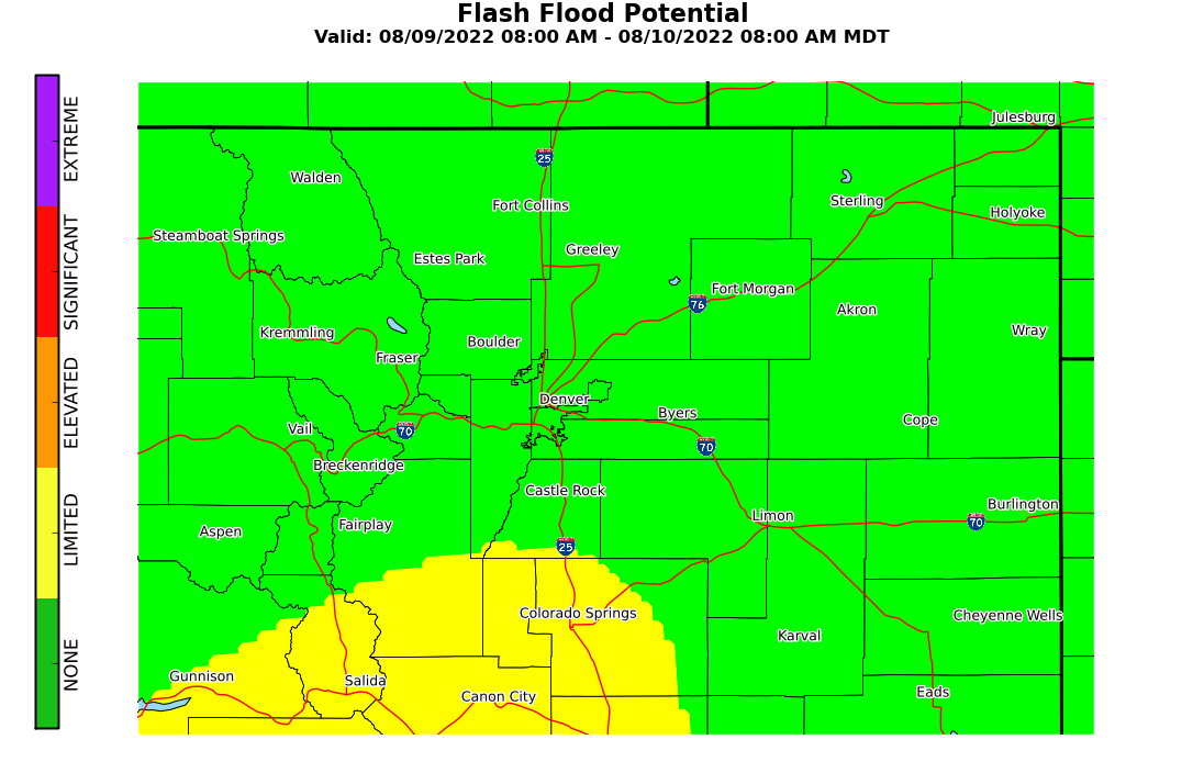
Today's Flash Flood/Flood Potential
 |
|
Risk Level
|
Definition
|
|
|
|
None
|
No Flooding risk.
|
|
|
Limited
|
Risk of localized flash flooding of small streams and low water crossings, and minor flooding of poor drainage or urban areas.
|
|
|
Elevated
|
Risk of flash flooding of several low water crossings, roads, and small streams, |
|
|
Significant
|
Risk of flash flooding of numerous roads, low water crossings, and small streams, |
|
|
Extreme
|
Risk of widespread flash flooding of low water crossings, roads, and small streams.
or Major river flooding. |
Rainfall Forecast for the next 24 Hours
River and Stream Levels along with Forecasts
(Click on an Gauge for a Hydrograph and latest Forecast)
Current Radar and Warnings
Real Time Lightning Data
Number of Lightning Strikes/Flashes over a 2 Minute Period provided by COLMA (updated every 60 seconds)
 ​
​

