Overview
Logan and Washington counties
Several tornadoes along with large hail occurred across portions of Logan and Washington counties on June 21, 2023. After thorough analysis of videos, chaser and spotter reports, up to 37 tornadoes occurred. Most of these were weak and short lived (under a minute), however, a few did attain EF2 intensity and were of longer duration over portions of Washington county. Fortunately, most of these were over open areas, with just a few locations experiencing damage. 27 of the tornadoes were produced by one slow moving supercell thunderstorm over Washington county.
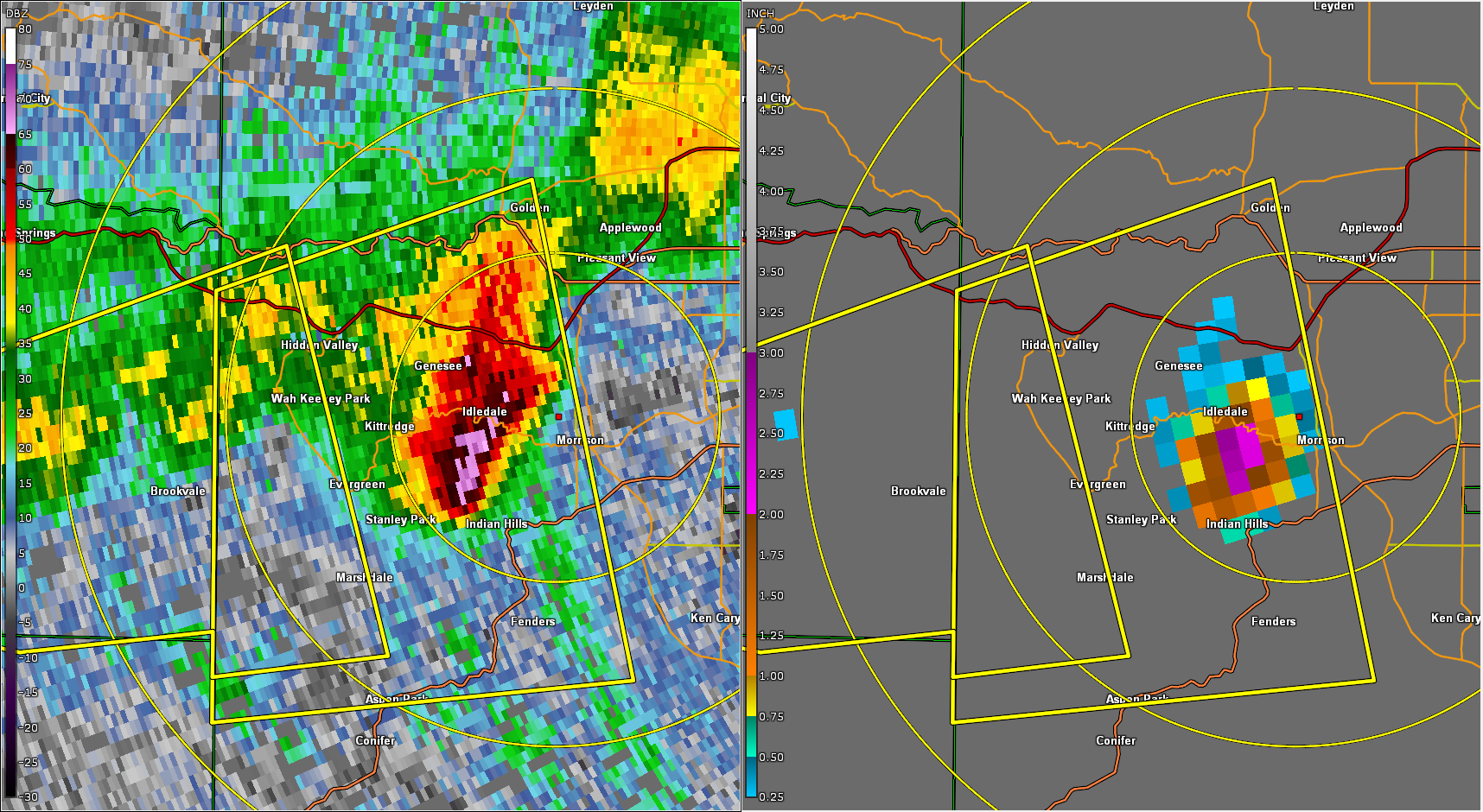
Red Rocks Amphitheater
A severe thunderstorm with 2" hail struck Red Rocks Amphitheater around 9:20 PM MDT that same evening. The hail injured nearly 100 concert-goers, with many requiring hospitalization. This was one of the worst hailstorms in Colorado regarding human injuries in a long time. There is a radar loop of that storm, along with NWS warnings, available on the radar tab.
Tornadoes:
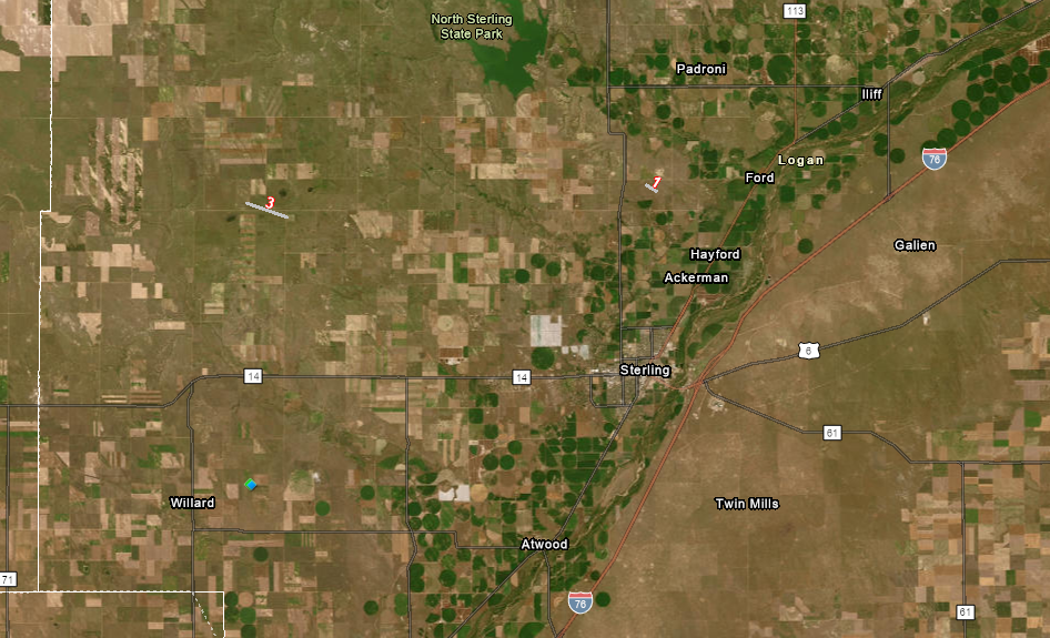
Tornado #1 - 5 miles SSW of Padroni
Logan, County
| Date |
June 21, 2023 |
| Time (Local) |
144 pm to 147 pm |
| EF Rating |
Unk |
| Est. Peak Winds |
Unk |
| Path Length |
0.50 mile |
| Max Width |
Unk |
| Injuries/Deaths |
None |
|
Summary:
Spotters report brief tornado over open fields.
|
Track Map
|
Tornado #2 - 6 miles SSW of Otis
Washington, County
| Date |
June 21, 2023 |
| Time (Local) |
305 pm to 310 pm |
| EF Rating |
Unk |
| Est. Peak Winds |
Unk |
| Path Length |
0.5 miles |
| Max Width |
Unk |
| Injuries/Deaths |
None |
|
Summary:
Chaser reports a brief tornado over open country.
|
|
Tornado #3 - 6 miles NNE of Pawnee Pass
Logan, County
| Date |
6/21/2023 |
| Time (Local) |
335 pm to 346 pm |
| EF Rating |
Unk |
| Est. Peak Winds |
Unk |
| Path Length |
1.5 miles |
| Max Width |
Unk |
| Injuries/Deaths |
None |
|
Summary:
Spotters report a tornado.
|
|
Tornado #4 - 3 miles NNE of Elba
Washington, County
| Date |
June 21. 2023 |
| Time (Local) |
410 pm to 411 pm |
| EF Rating |
Unk |
| Est. Peak Winds |
Unk |
| Path Length |
0.25 miles |
| Max Width |
25 yards |
| Injuries/Deaths |
None |
|
Summary:
Chaser reports brief tornado.
|
Track Map
|
Tornado #5 - 4 miles NNE of Elba
Washington, County
| Date |
June 21, 2023 |
| Time (Local) |
418 pm to 422 pm |
| EF Rating |
Unk |
| Est. Peak Winds |
Unk |
| Path Length |
0.50 miles |
| Max Width |
Unk |
| Injuries/Deaths |
None |
|
Summary:
Chaser reports a tornado.
|
Track Map
|
Tornado #6 - 4 miles NNE of Elba
Washington, County
| Date |
6/21/2023 |
| Time (Local) |
425 pm to 426 pm |
| EF Rating |
Unk |
| Est. Peak Winds |
Unk |
| Path Length |
1.0 |
| Max Width |
50 yards |
| Injuries/Deaths |
None |
|
Summary:
Chaser reports a tornado.
|
Track Map
|
Tornado #7 - 4 miles NNE of Elba
Washington, County
| Date |
June 21, 2023 |
| Time (Local) |
428 pm to 429 pm |
| EF Rating |
Unk |
| Est. Peak Winds |
Unk |
| Path Length |
0.25 miles |
| Max Width |
50 yards |
| Injuries/Deaths |
None |
|
Summary:
Chaser reports brief rope tornado.
|
Track Map
|
Tornado #8 - 4.5 miles north of Elba
Washington, County
| Date |
June 21, 2023 |
| Time (Local) |
428 pm to 435 pm |
| EF Rating |
EF2 |
| Est. Peak Winds |
118 mph |
| Path Length |
1.5 miles |
| Max Width |
400 yards |
| Injuries/Deaths |
None |
|
Summary:
Snapped Power Poles along Hwy 63 associated with the large tornado.
|
Large Tornado with 2 satellite Tornadoes
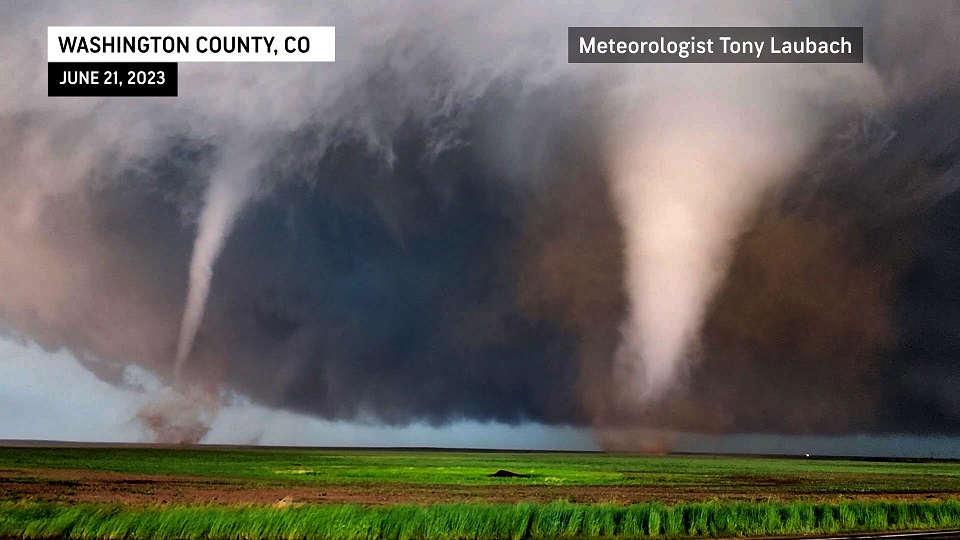
Photo from Tony Laubach/Meteorologist AccuWeather
|
Tornado #9 - 4.5 miles NNE of Elba
Washington, County
| Date |
June 21, 2023 |
| Time (Local) |
429 pm to 430 pm |
| EF Rating |
Unk |
| Est. Peak Winds |
Unk |
| Path Length |
0.50 miles |
| Max Width |
50 yards |
| Injuries/Deaths |
None |
|
Summary:
Chaser reports brief satellite tornado associated with Tornado #8
|
Remnants of 1st satellite Tornado just behind 2nd Satellite Tornado
Photo from Tony Laubach/Meteorologist AccuWeather
|
Tornado #10 - 4.5 miles NNE of Elba
Washington, County
| Date |
June 21, 2023 |
| Time (Local) |
431 pm to 434 pm |
| EF Rating |
Unk |
| Est. Peak Winds |
Unk |
| Path Length |
4 miles |
| Max Width |
50 yards |
| Injuries/Deaths |
None |
|
Summary:
Chaser reports 2nd stronger satellite tornado develops and eventually wraps into main Tornado #8.
|
2nd stronger satellite Tornado
Photo from Tony Laubach/Meteorologist AccuWeather
|
Tornado #11 - 5 miles north of Elba
Washington, County
| Date |
June 21, 2023 |
| Time (Local) |
436 pm to 437 pm |
| EF Rating |
Unk |
| Est. Peak Winds |
Unk |
| Path Length |
0.50 miles |
| Max Width |
Unk |
| Injuries/Deaths |
None |
|
Summary:
Chaser video shows another tornado developing.
|
New Tornado just west of Hwy 63
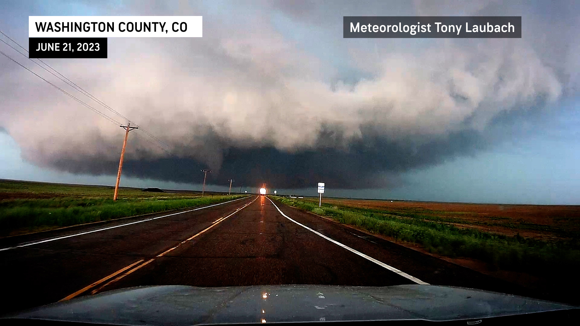
Photo from Tony Laubach/Meteorologist AccuWeather
|
Tornado #12 - 5 miles north of Elba
Washington, County
| Date |
June 21, 2023 |
| Time (Local) |
437 pm to 438 pm |
| EF Rating |
Unk |
| Est. Peak Winds |
Unk |
| Path Length |
0.50 miles |
| Max Width |
Unk |
| Injuries/Deaths |
None |
|
Summary:
Chaser video shows another tornado developing west of Hwy 63 after #11 dissipates.
|
Another Tornado develops after #11 ends
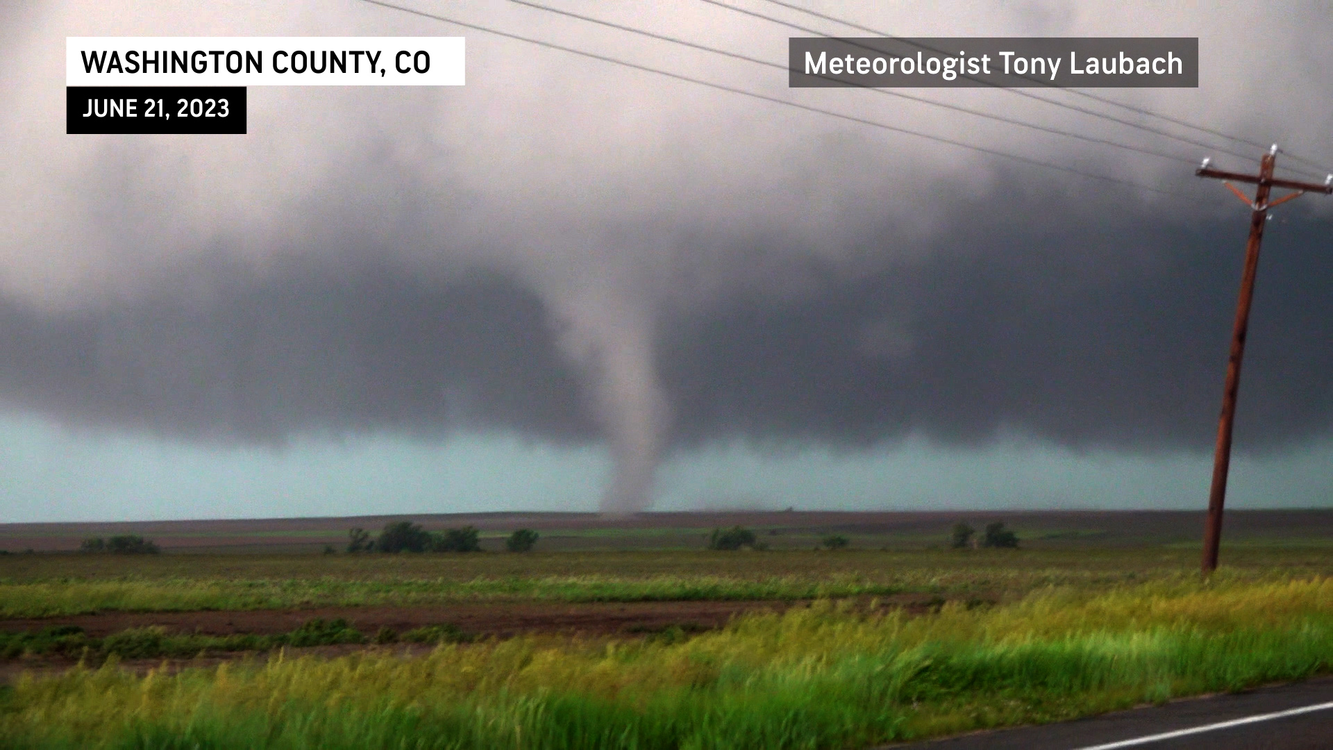
Photo from Tony Laubach/Meteorologist AccuWeather
|
Tornado #13 - 5 miles north of Elba
Washington County
| Date |
June 21, 2023 |
| Time (Local) |
439 pm to 440 pm |
| EF Rating |
Unk |
| Est. Peak Winds |
Unk |
| Path Length |
0.25 miles |
| Max Width |
Unk |
| Injuries/Deaths |
None |
|
Summary:
Chaser video shows brief tornado which only lasts 30 seconds.
|
Another brief Tornado develops after #12 ends
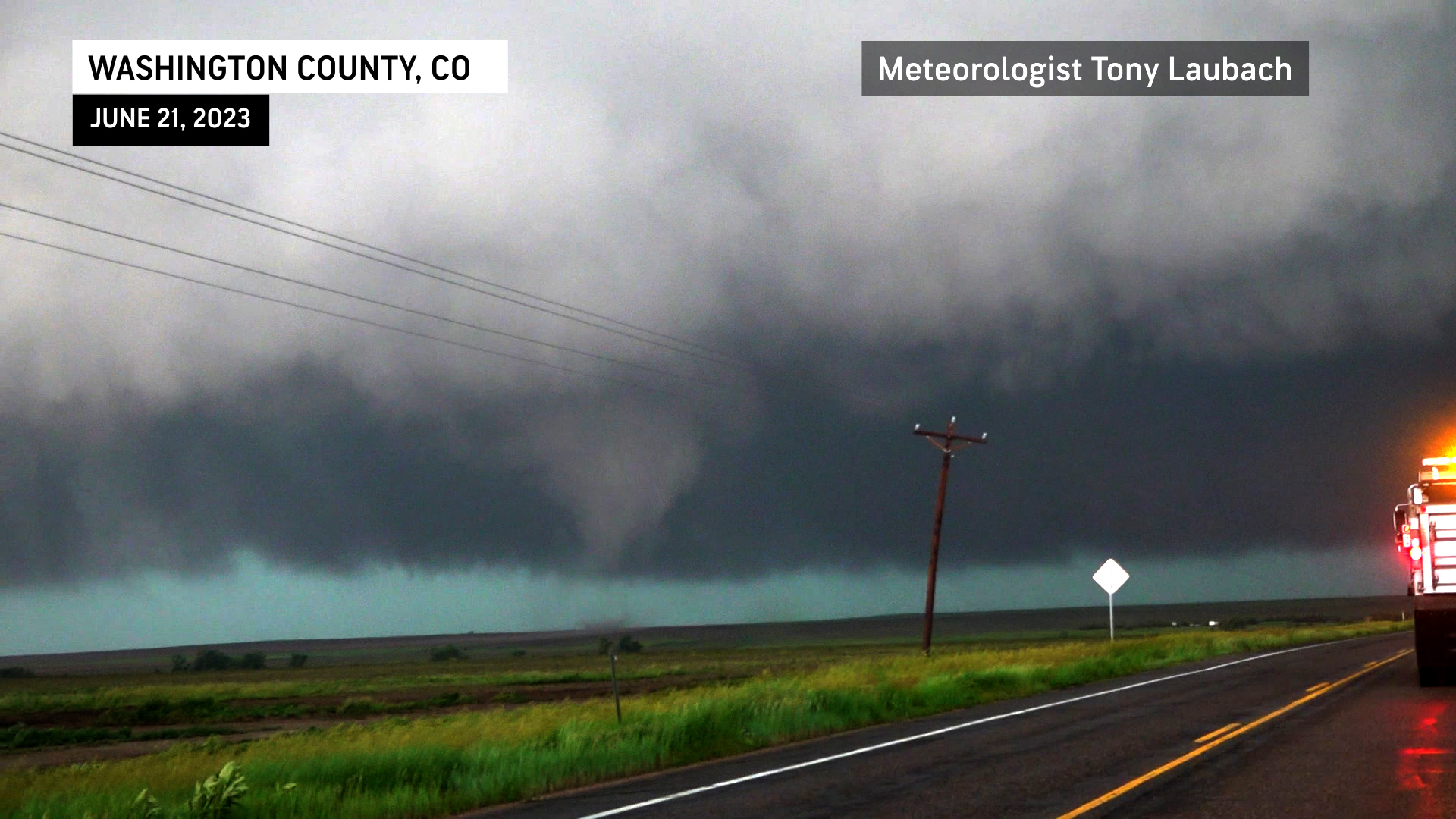
Photo from Tony Laubach/Meteorologist AccuWeather
|
Tornado #14 - 5 miles north of Elba
Washington, County
| Date |
June 21, 2023 |
| Time (Local) |
440 pm to 441 pm |
| EF Rating |
Unk |
| Est. Peak Winds |
Unk |
| Path Length |
0.5 miles |
| Max Width |
Unk |
| Injuries/Deaths |
None |
|
Summary:
Chaser video shows another tornado developing as #13 has ended.
|
A new Tornado develops after #13 ends
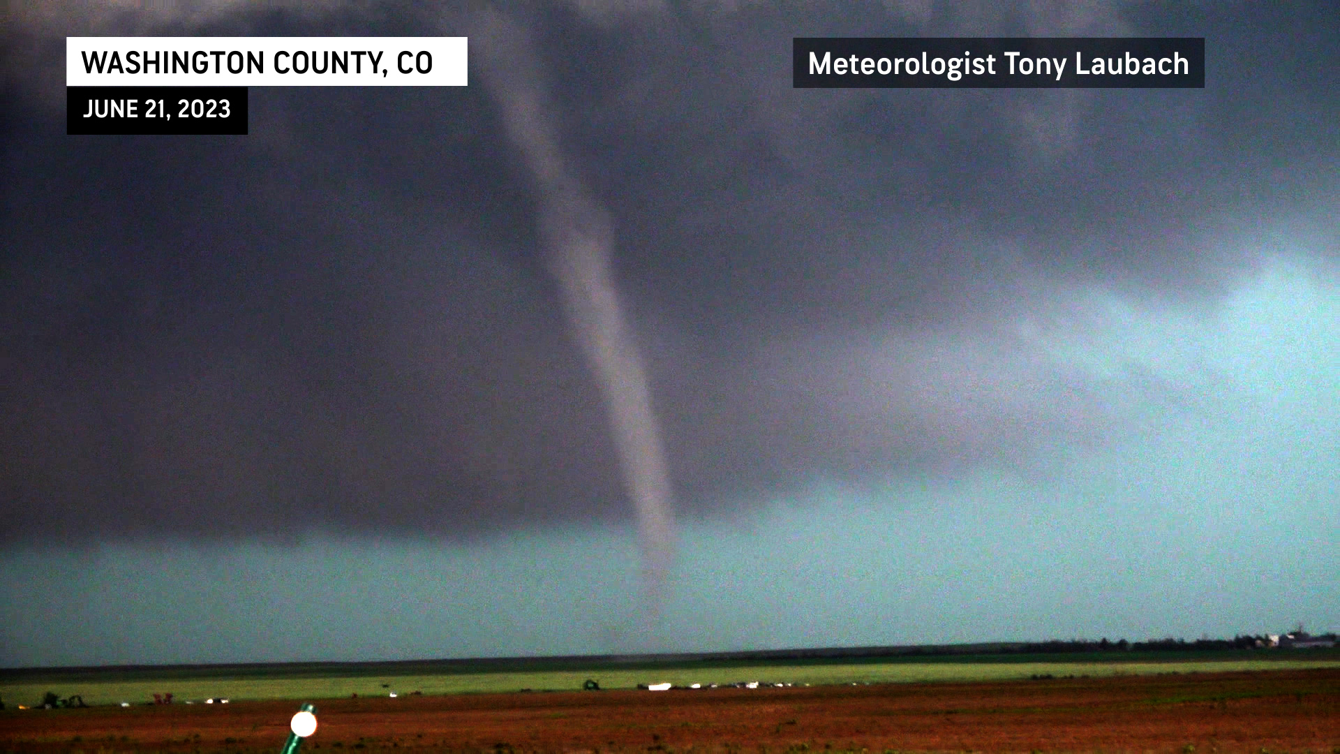
Photo from Tony Laubach/Meteorologist AccuWeather
|
Tornado #15 - 5.4 miles north of Elba
Washington, County
| Date |
June 21. 2023 |
| Time (Local) |
442 pm to 443 pm |
| EF Rating |
Unk |
| Est. Peak Winds |
Unk |
| Path Length |
0.25 miles |
| Max Width |
Unk |
| Injuries/Deaths |
None |
|
Summary:
Chaser video shows another brief tornado after #14 ends.
|
Another brief Tornado develops as #14 ends
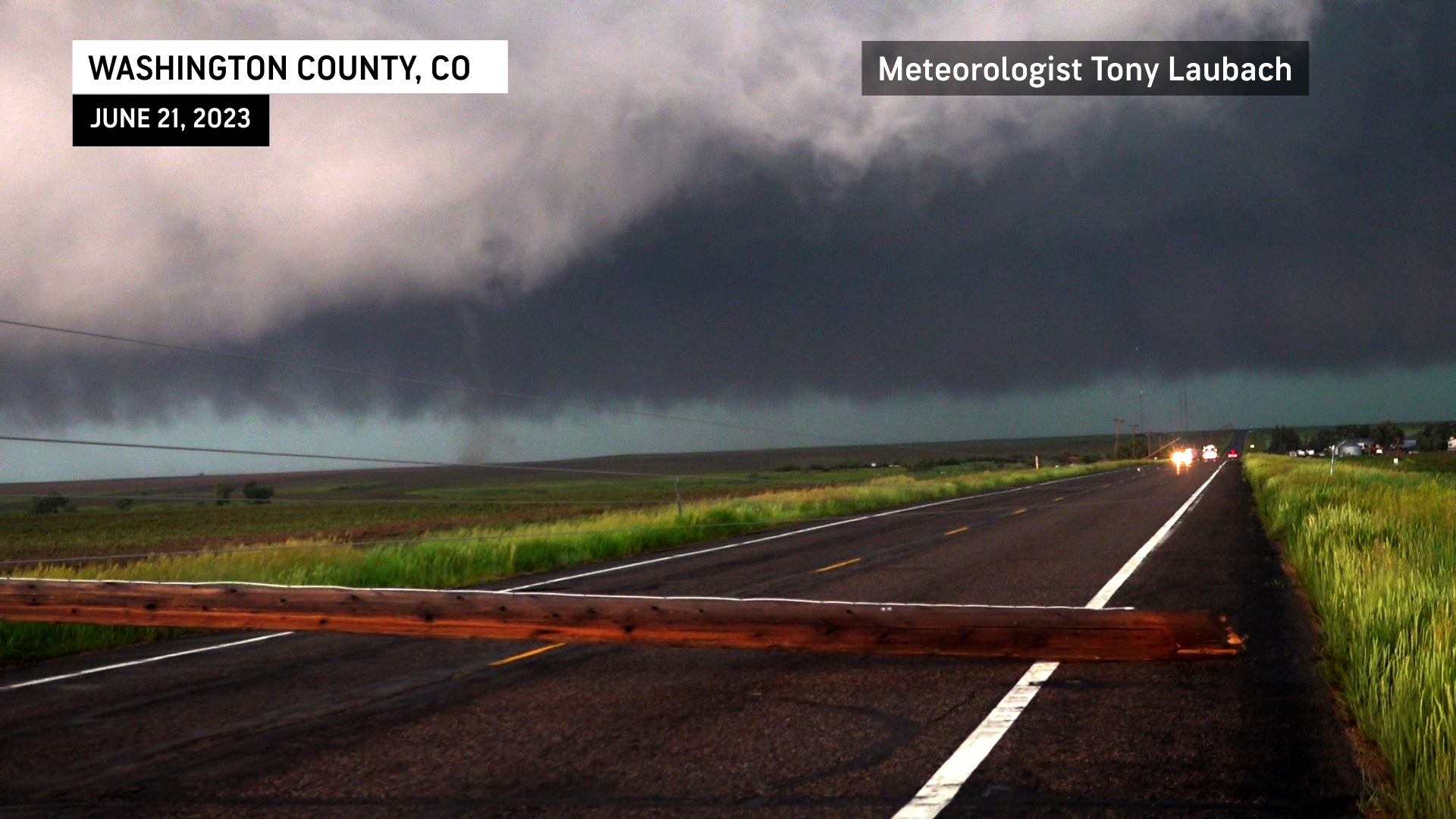
Photo from Tony Laubach/Meteorologist AccuWeather
|
Tornado #16 - 5.5 miles north of Elba
Washington, County
| Date |
June 21, 2023 |
| Time (Local) |
443 pm to 445 pm |
| EF Rating |
Unk |
| Est. Peak Winds |
Unk |
| Path Length |
1.0 mile |
| Max Width |
Unk |
| Injuries/Deaths |
None |
|
Summary:
Chaser video shows a large tornado developing,
|
Large Tornado develops after #15 ends
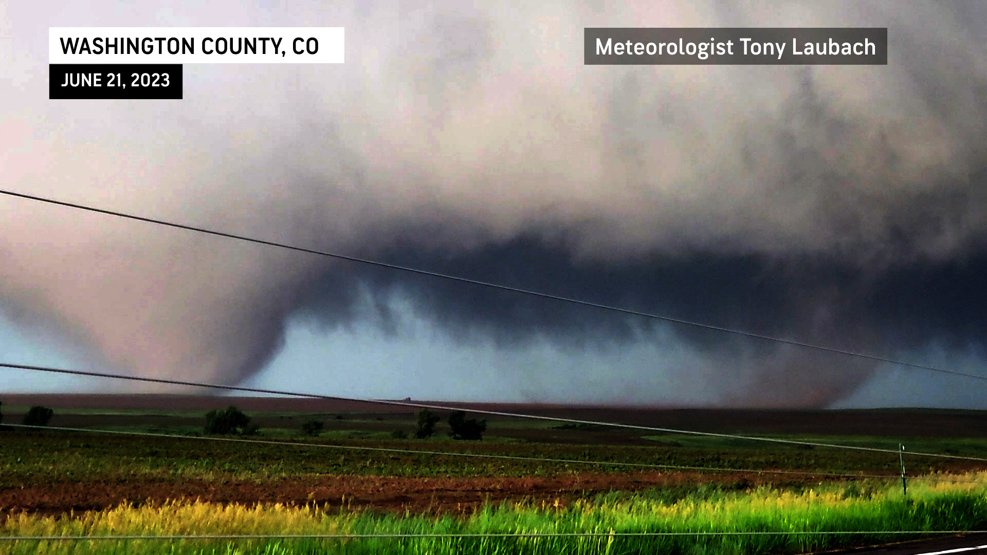
Photo from Tony Laubach/Meteorologist AccuWeather
|
Tornado #17 - 5.7 miles NNW of Elba
Washington, County
| Date |
June 21, 2023 |
| Time (Local) |
443 pm to 445 pm |
| EF Rating |
Unk |
| Est. Peak Winds |
Unk |
| Path Length |
0.5 miles |
| Max Width |
Unk |
| Injuries/Deaths |
None |
|
Summary:
Chaser video shows another large tornado east of #16.
|
2nd large Tornado develops east of #16
Photo from Tony Laubach/Meteorologist AccuWeather
|
Tornado #18 - 6 miles north of Elba
Washington, County
| Date |
June 21, 2023 |
| Time (Local) |
445 pm to 446 pm |
| EF Rating |
Unk |
| Est. Peak Winds |
Unk |
| Path Length |
0.5 miles |
| Max Width |
Unk |
| Injuries/Deaths |
None |
|
Summary:
Chaser video shows a new tornado developing as #16 and #17 have dissipated.
|
New tornado develops after #16 and #17 have ended
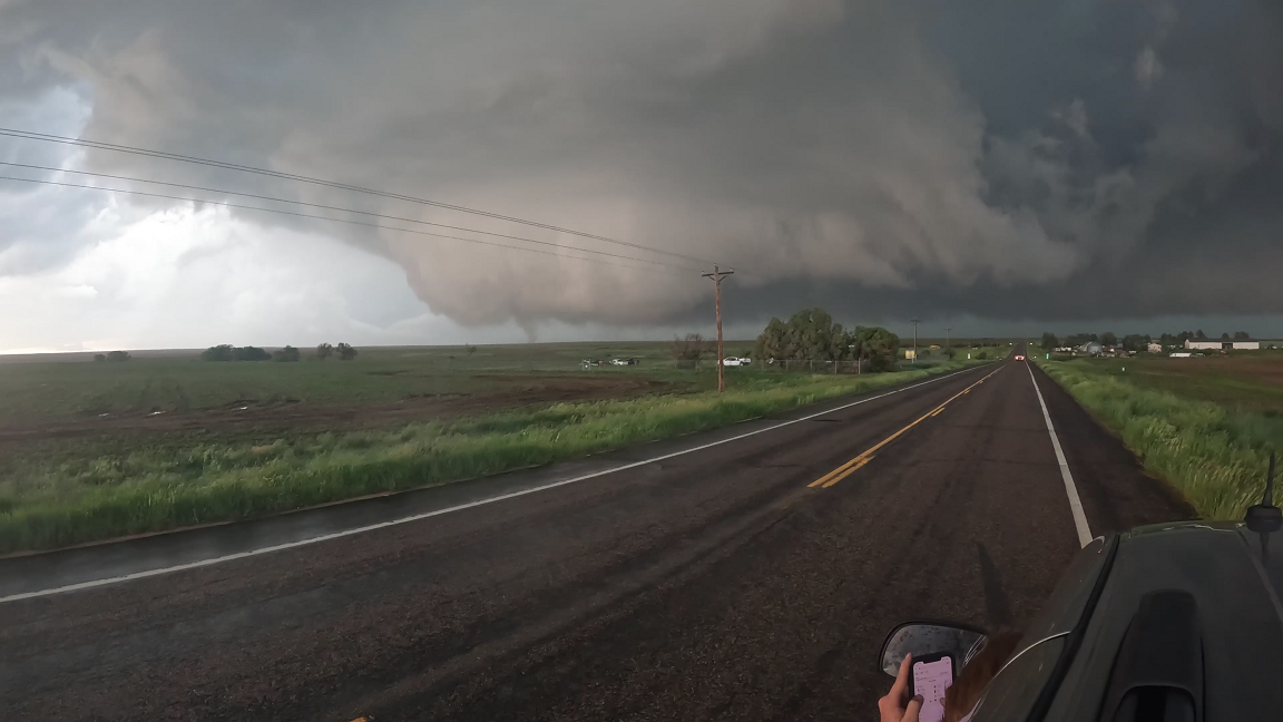
Photo from video taken by Michael Schoenecker
|
Tornado #19 - 6 miles north of Elba
Washington, County
| Date |
June 21, 2023 |
| Time (Local) |
445 pm to 446 pm |
| EF Rating |
Unk |
| Est. Peak Winds |
Unk |
| Path Length |
0.25 miles |
| Max Width |
Unk |
| Injuries/Deaths |
None |
|
Summary:
Chaser video shows another brief tornado to the east of #18 as it remains on the ground.
|
2nd brief Tornado develops east of #18
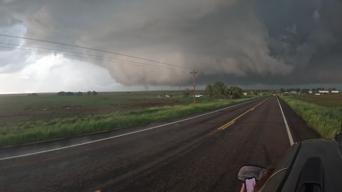
Photo from video taken by Michael Schoenecker
|
Tornado #20 - 6 miles north of Elba
Washington, County
| Date |
June 21, 2023 |
| Time (Local) |
446 pm to 447 pm |
| EF Rating |
Unk |
| Est. Peak Winds |
Unk |
| Path Length |
0.50 miles |
| Max Width |
Unk |
| Injuries/Deaths |
None |
|
Summary:
Chaser video shows another brief tornado which only lasts 30 seconds as #18 and #19 have dissipated.
|
New Tornado develops to the west after #18 and #19 have ended
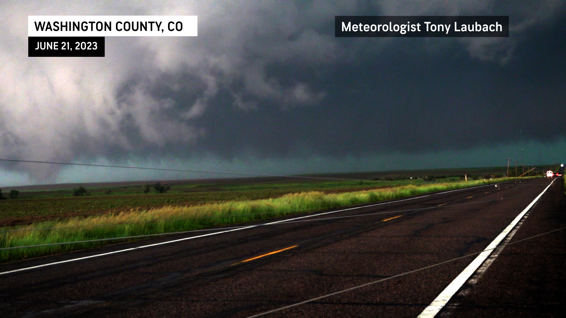
Photo from Tony Laubach/Meteorologist AccuWeather
|
Tornado #21 - 6 miles north of Elba
Washington, County
| Date |
June 21, 2023 |
| Time (Local) |
447 pm to 448 pm |
| EF Rating |
Unk |
| Est. Peak Winds |
Unk |
| Path Length |
0.50 miles |
| Max Width |
Unk |
| Injuries/Deaths |
None |
|
Summary:
Another tornado develops as #20 ends.
|
Another Tornado develops as #20 ends
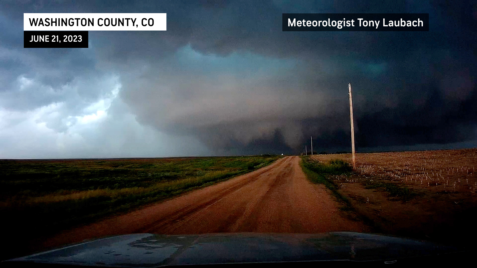
Photo from Tony Laubach/Meteorologist AccuWeather
|
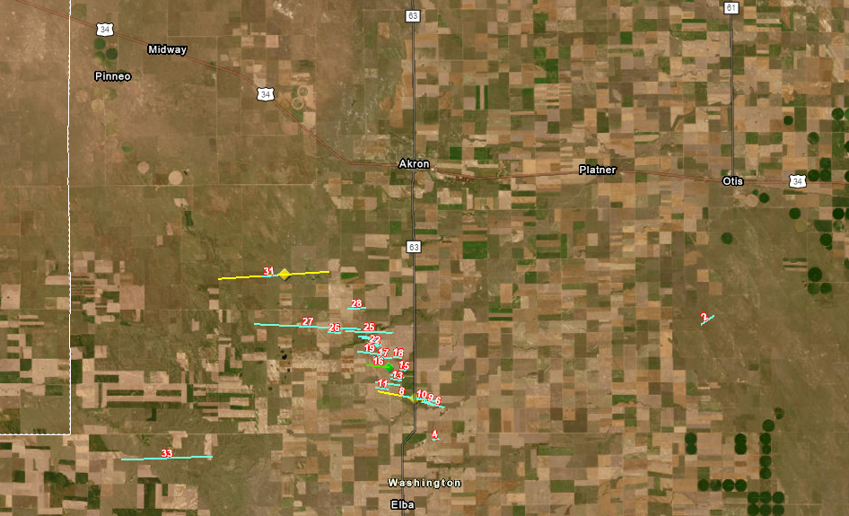
Tornado #22 - 7.5 miles south of Akron
Washington, County
| Date |
June 21, 2023 |
| Time (Local) |
448 pm to 449 pm |
| EF Rating |
Unk |
| Est. Peak Winds |
Unk |
| Path Length |
0.5 miles |
| Max Width |
Unk |
| Injuries/Deaths |
None |
|
Summary:
Chaser video shows new tornado developing as #21 dissipates.
|
Another Tornado develops as #21 has ended
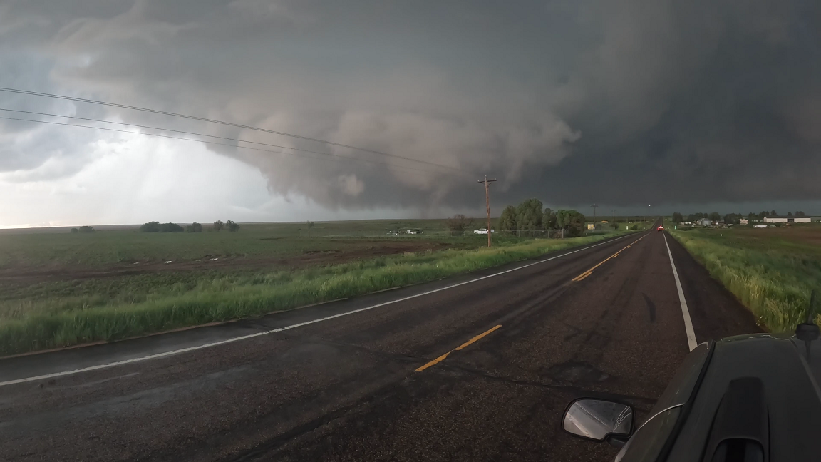
Photo from video taken by Michael Schoenecker
|
Tornado #23 - 7.4 miles SSW of Akron
Washington, County
| Date |
June 21, 2023 |
| Time (Local) |
449 pm to 450 pm |
| EF Rating |
Unk |
| Est. Peak Winds |
Unk |
| Path Length |
0.5 miles |
| Max Width |
Unk |
| Injuries/Deaths |
None |
|
Summary:
Chaser video shows another large tornado developing as #22 dissipates.
|
New larger Tornado develops after #22 has ended
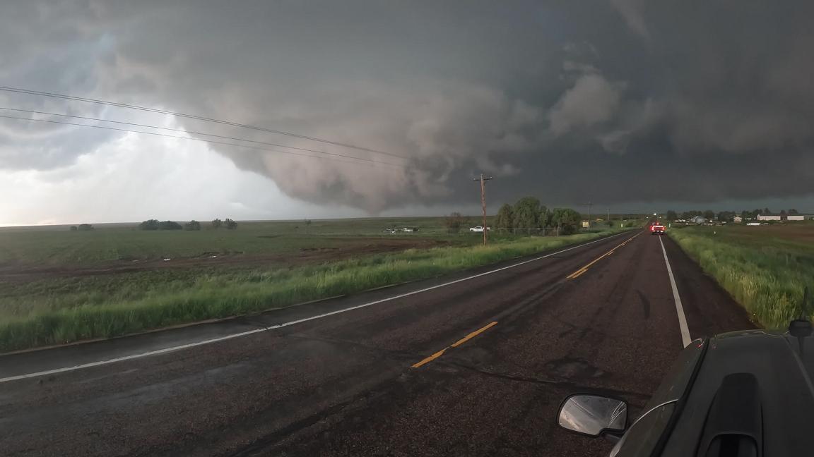
Photo from video taken by Michael Schoenecker
|
Tornado #24 - 7.3 miles SSW of Akron
Washington, County
| Date |
June 21, 2023 |
| Time (Local) |
450 pm to 451 pm |
| EF Rating |
Unk |
| Est. Peak Winds |
Unk |
| Path Length |
0.5 miles |
| Max Width |
Unk |
| Injuries/Deaths |
None |
|
Summary:
Chaser video shows new Tornado developing as #23 dissipates.
|
New Tornado develops further west after #23 ends
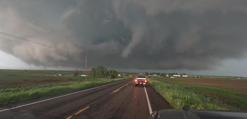
Photo from video taken by Michael Schoenecker
|
Tornado #25 - 7.2 miles SSW of Akron
Washington, County
| Date |
June 21, 2023 |
| Time (Local) |
451 pm to 452 pm |
| EF Rating |
Unk |
| Est. Peak Winds |
Unk |
| Path Length |
0.5 miles |
| Max Width |
Unk |
| Injuries/Deaths |
None |
|
Summary:
Chaser video shows a new tornado as #24 dissipates.
|
New Tornado which is hard to see develops after #24 ends
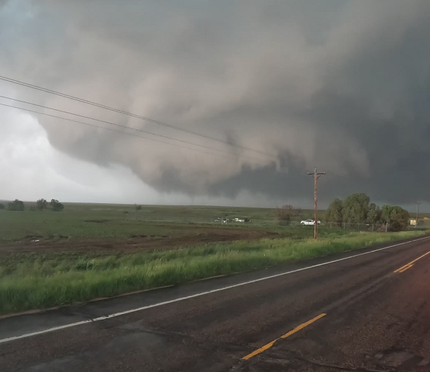
Photo from video taken by Michael Schoenecker
|
Tornado #26 - 7 miles SSW of Akron
Washington, County
| Date |
June 21, 2023 |
| Time (Local) |
452 pm to 455 pm |
| EF Rating |
Unk |
| Est. Peak Winds |
Unk |
| Path Length |
2 miles |
| Max Width |
200 yards |
| Injuries/Deaths |
None |
|
Summary:
Chaser video shows a new tornado developing as #25 dissipates.
|
Another Tornado develops further west as #25 ends
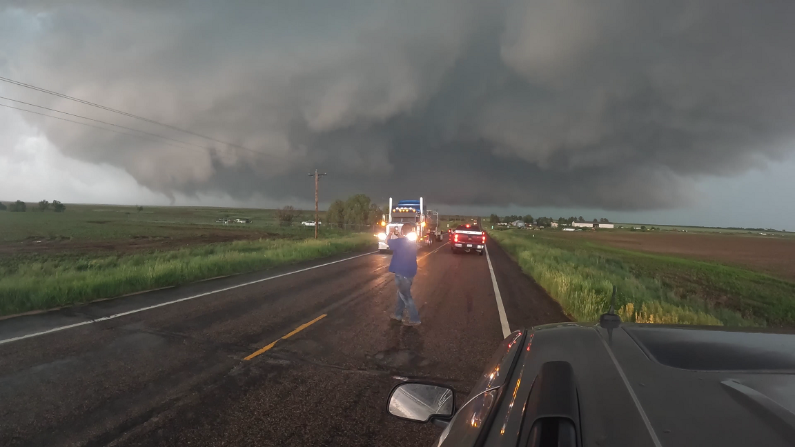
Photo from video taken by Michael Schoenecker
|
Tornado #27 - 7 miles SSW of Akron
Washington, County
| Date |
June 21, 2023 |
| Time (Local) |
453 pm to 456 pm |
| EF Rating |
Unk |
| Est. Peak Winds |
Unk |
| Path Length |
0.5 miles |
| Max Width |
Unk |
| Injuries/Deaths |
None |
|
Summary:
Chaser video shows another tornado developing to the west of #26 with both on the ground at the same time.
|
Another Tornado develops west of #26
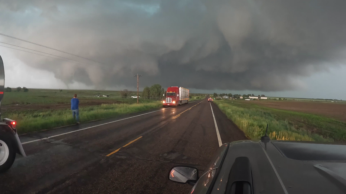
Photo from video taken by Michael Schoenecker
|
Tornado #28 - 6.9 miles SSW of Akron
Washington, County
| Date |
June 21, 2023 |
| Time (Local) |
457 pm to 510 pm |
| EF Rating |
Unk |
| Est. Peak Winds |
Unk |
| Path Length |
Unk |
| Max Width |
400 yards |
| Injuries/Deaths |
None |
|
Summary:
Chasers report large multi vortex tornado 2 miles west of Hwy 63 moving west.
|
Large multi vortex develops a few miles west of Hwy 63.
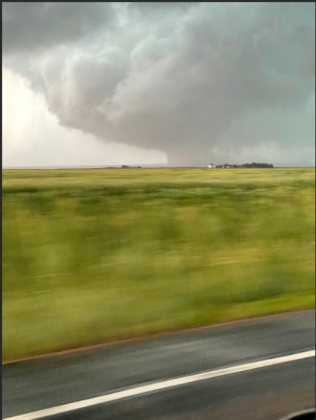
Photo from video taken by Michael Schoenecker
|
Tornado #29 - 6 miles SSW of Akron
Washington, County
| Date |
June 21, 2023 |
| Time (Local) |
515 pm to 519 pm |
| EF Rating |
Unk |
| Est. Peak Winds |
Unk |
| Path Length |
1 mile |
| Max Width |
50 yards |
| Injuries/Deaths |
None |
|
Summary:
Chaser reports brief tornado.
|
Track Map
|
Tornado #30 - 5.5 miles SSW of Akron
Washington, County
| Date |
June 21, 2023 |
| Time (Local) |
520 pm to 536 pm |
| EF Rating |
EF2 |
| Est. Peak Winds |
118 mph |
| Path Length |
3 miles |
| Max Width |
400 yards |
| Injuries/Deaths |
None |
|
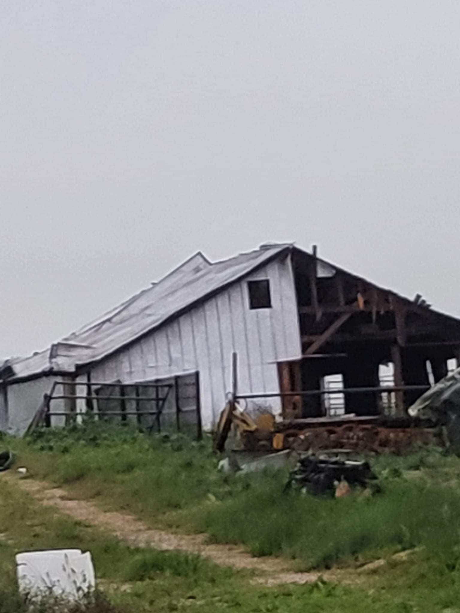
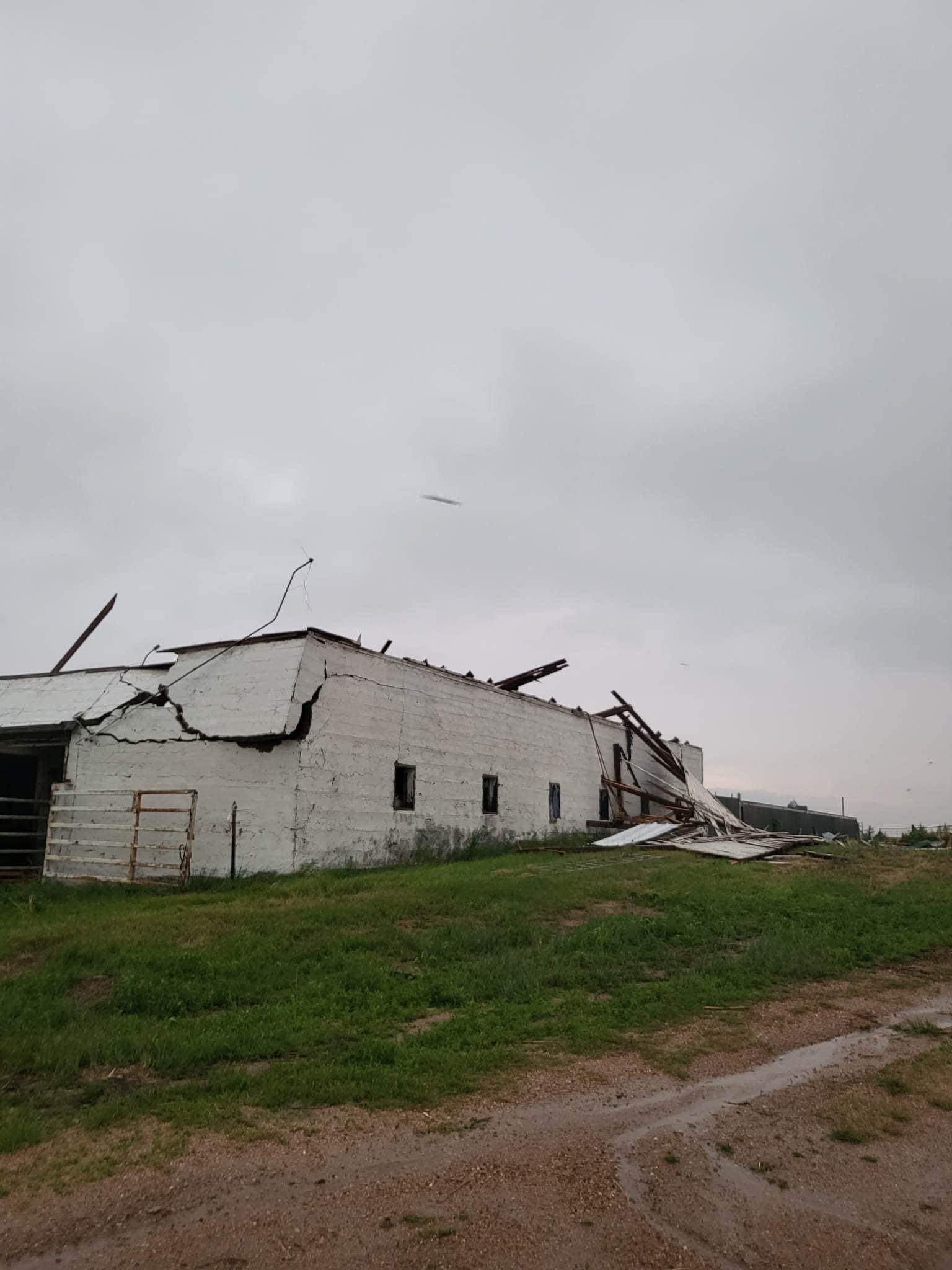
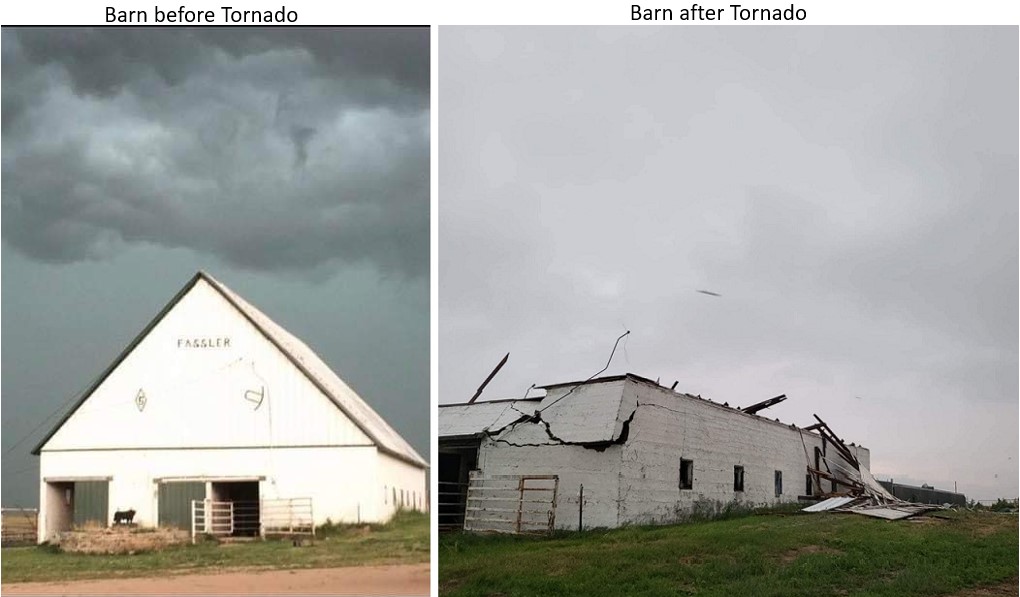
Summary:
This large tornado damaged a farm with a large barn destroyed along with grain bins. A few power poles snapped near this area as well.
|
Large Tornado moving west
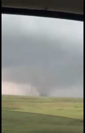
Photo from video taken by Michael Schoenecker
|
Tornado #31 - 5.5 miles SSW of Akron
Washington, County
| Date |
June 21, 2023 |
| Time (Local) |
530 pm to 532 pm |
| EF Rating |
Unk |
| Est. Peak Winds |
Unk |
| Path Length |
0.50 miles |
| Max Width |
50 yards |
| Injuries/Deaths |
None |
|
Summary:
A second smaller satellite tornado develops to the west of the main larger tornado.
|
Small Satellite Tornado develops west of #30
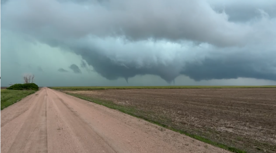
Photo from video taken by Keaton Terry
|
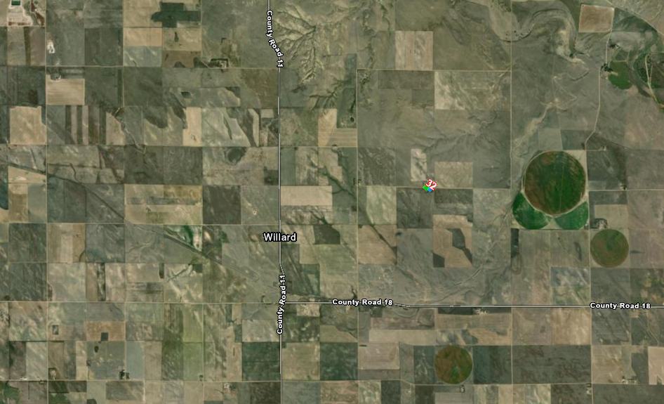
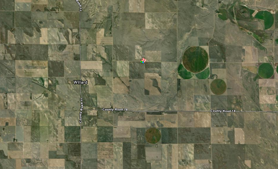
Tornado #32 - 2 miles NE of Willard
Washington, County
| Date |
June 21, 2023 |
| Time (Local) |
530 pm to 540 pm |
| EF Rating |
EF1 |
| Est. Peak Winds |
110 mph |
| Path Length |
0.25 miles |
| Max Width |
.15 yards |
| Injuries/Deaths |
None |
|
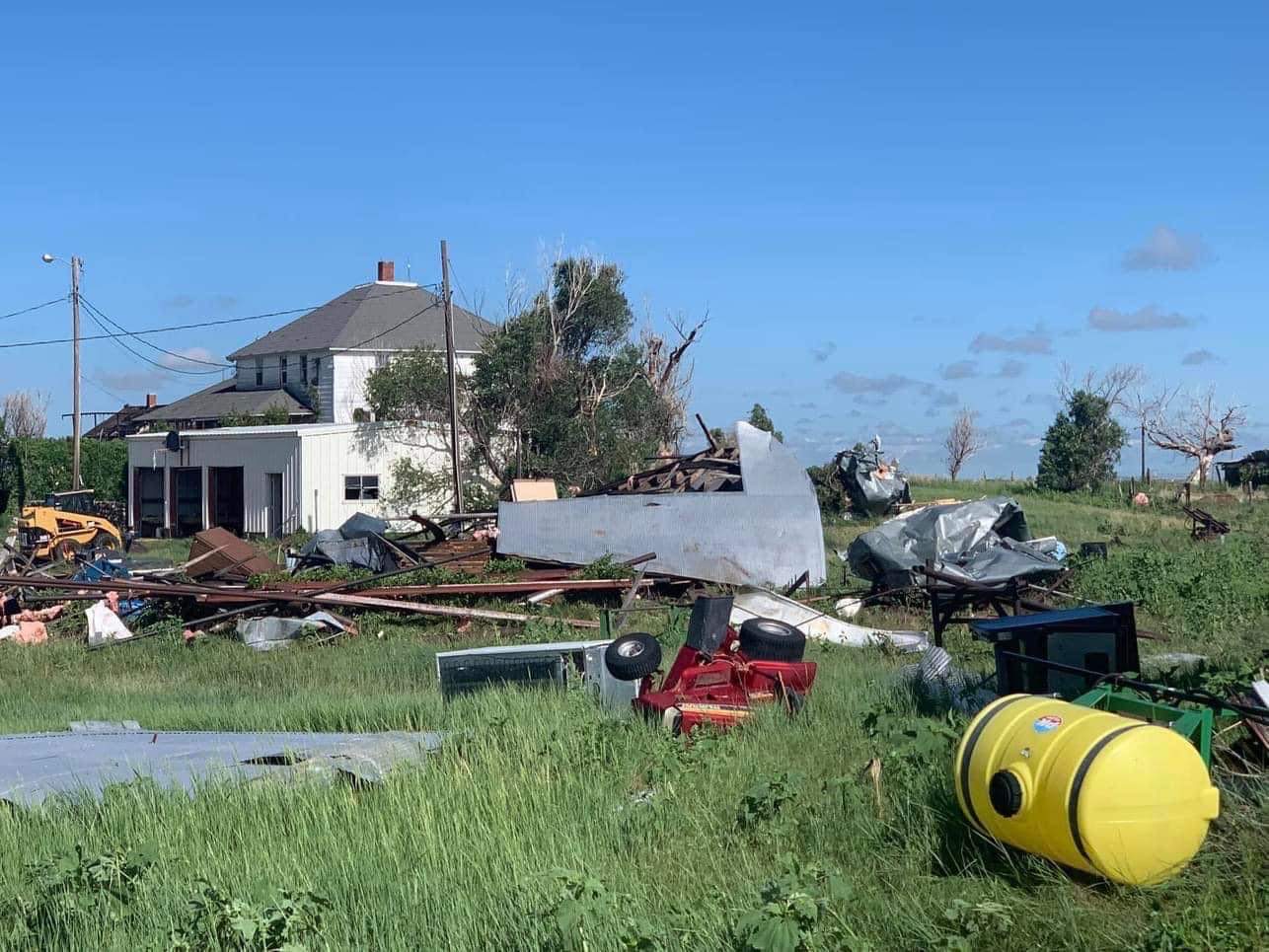
Summary:
Tornado damages a house.
|
Track Map
|
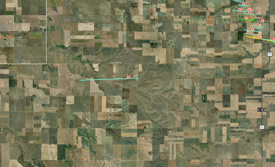
Tornado #33 - 8 miles east of Woodrow
Washington County
| Date |
June 21, 2023 |
| Time (Local) |
539 to 553 pm |
| EF Rating |
Unk |
| Est. Peak Winds |
Unk |
| Path Length |
Unk |
| Max Width |
Unk |
| Injuries/Deaths |
None |
|
Summary:
Chaser reports a tornado.
|
Track Map
|
Tornado #34 - 5.5 miles north of Anton
Washington, County
| Date |
June 21, 2023 |
| Time (Local) |
614 pm to 615 pm |
| EF Rating |
Unk |
| Est. Peak Winds |
Unk |
| Path Length |
1 mile |
| Max Width |
50 yards |
| Injuries/Deaths |
None |
|
Summary:
Chaser reports an Anti-Cyclonic tornado,
|
Track Map
Twitter Video of Anti Cyclonic Tornado
|
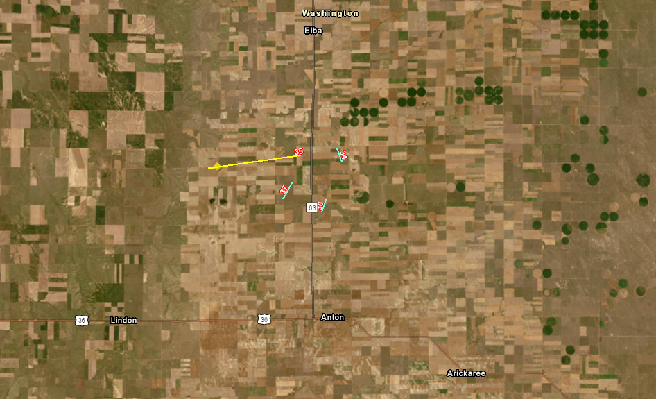
Tornado #35 - 6 miles south of Elba
Washington County
| Date |
June 21, 2023 |
| Time (Local) |
616 pm to 622 pm |
| EF Rating |
EF2 |
| Est. Peak Winds |
118 mph |
| Path Length |
4 miles |
| Max Width |
800 yards |
| Injuries/Deaths |
None |
|
Summary:
Large Multi Vortex Tornado snaps power poles.
|
Track Map
|
Tornado #36 - 5 miles SSE of Elba
Washington County
| Date |
June 21, 2023 |
| Time (Local) |
635 pm to 640 pm |
| EF Rating |
Unk |
| Est. Peak Winds |
Unk |
| Path Length |
1 mile |
| Max Width |
50 yards |
| Injuries/Deaths |
None |
|
Summary:
Chaser reports a tornado.
|
Track Map
|
Tornado #37 - 6 miles NNW of Anton
Washington County
| Date |
June 21, 2023 |
| Time (Local) |
645 pm to 700 pm |
| EF Rating |
Unk |
| Est. Peak Winds |
Unk |
| Path Length |
Unk |
| Max Width |
Unk |
| Injuries/Deaths |
None |
|
Summary:
Spotter reports a tornado.
|
Track Map
|
The Enhanced Fujita (EF) Scale classifies tornadoes into the following categories:
EF0
Weak
65-85 mph |
EF1
Moderate
86-110 mph |
EF2
Significant
111-135 mph |
EF3
Severe
136-165 mph |
EF4
Extreme
166-200 mph |
EF5
Catastrophic
200+ mph |
 |
Interactive Tornado Tracks Map
Zooming in will show the Tornado number
Radar
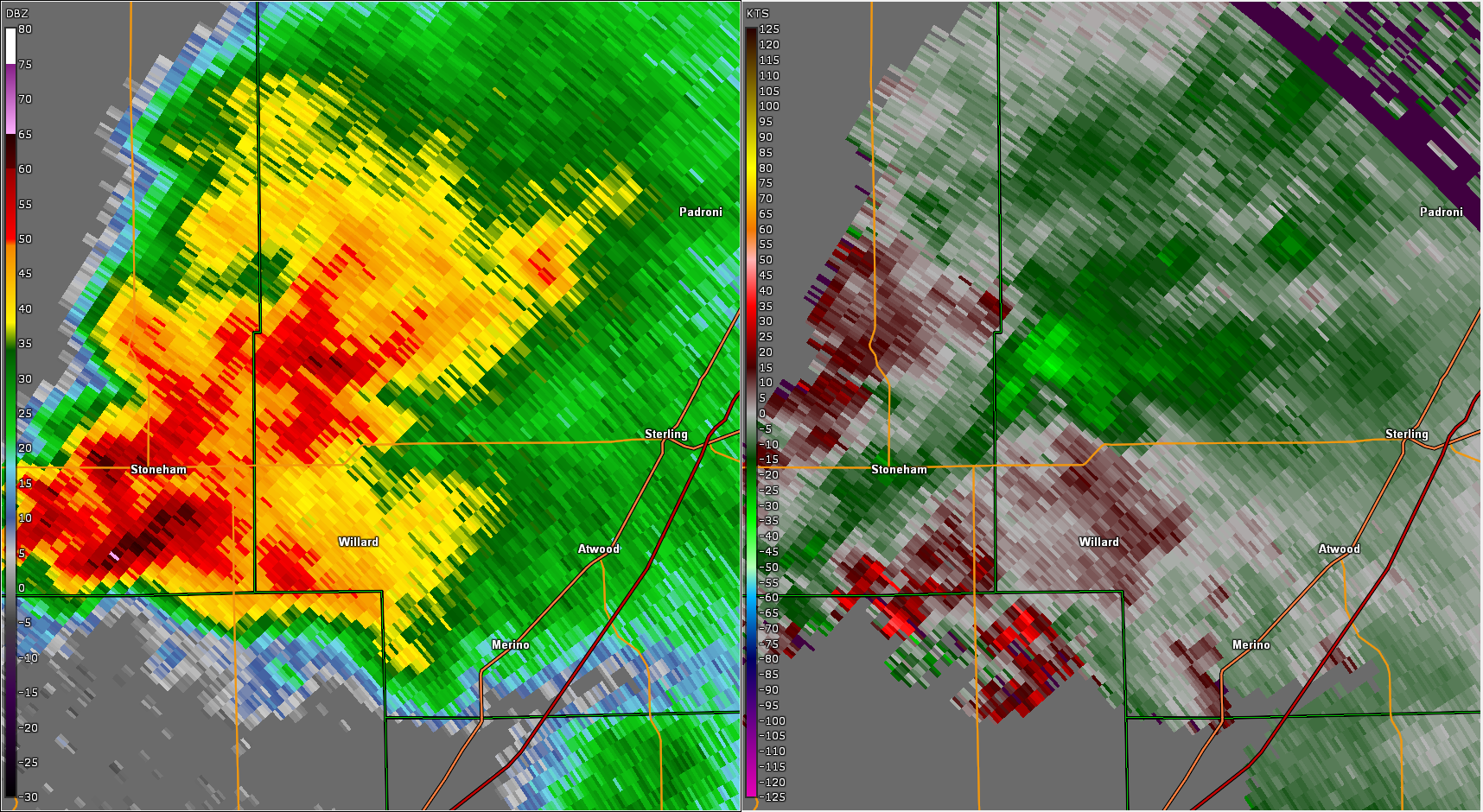 |
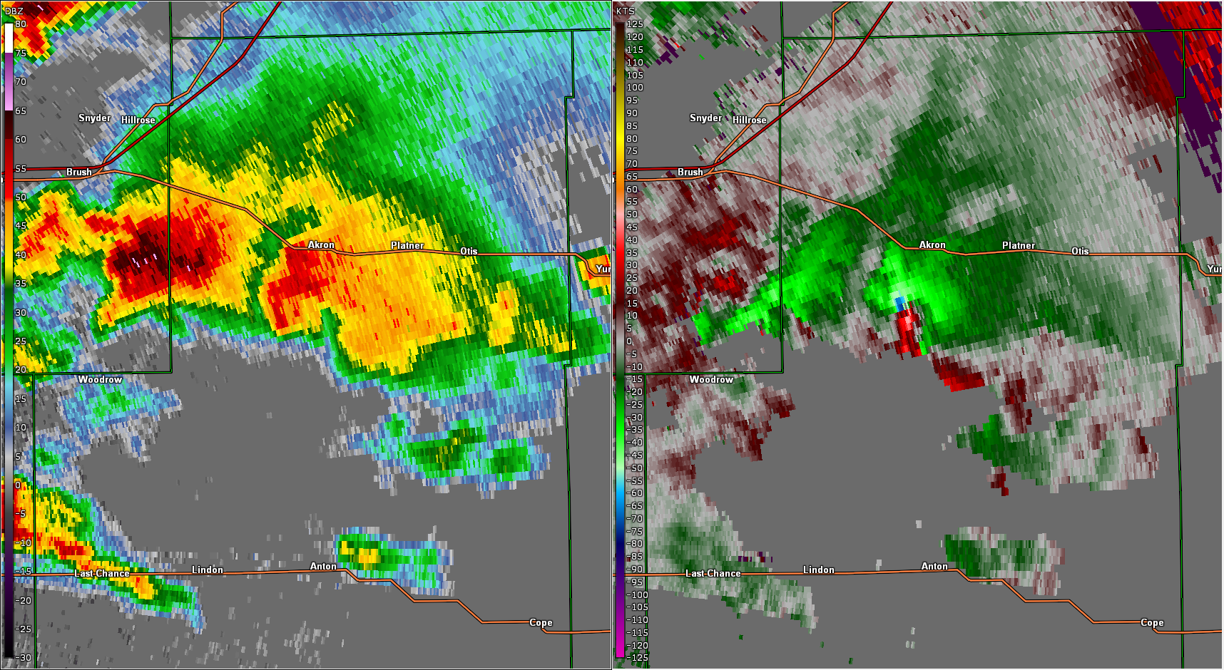 |
 |
|
| Clicking the image above will take you to a YouTube radar animation from the event over Logan County. |
Clicking the image above will take you to a YouTube radar animation from the event over Washington County. |
Clicking the image above will take you to a YouTube radar animation from the event over Red Rocks Amphitheater. |
|
Historical Precedence
How Does This Compare to Other Events?
Tornado Statistics
- This is by far the most tornadoes confirmed on a calendar day in the state of Colorado. The previous high marks:
- 5/17/2000: 27
- 5/28/2018: 21
- 6/4/2015: 21
- 4/22/2010: 20
***This does not mean June 21 actually had the most tornadoes in the state ever, because GPS, smartphones with Hollywood quality cameras, storm chasers, increasing population all mean that tornadoes that occur are being reported better than at any time in history***
Warning Counts
Data is based on a 24-hour period (6A-6A MDT)
- 68 SVR Warnings - Nearly 17 mins average lead time
- Previous 24hr Record - 27 on June 18th 2018
- 17 TOR Warnings - Nearly 12 mins average lead time
- 24hr Record - 22 on August 3rd 2013
- Also ties with May 10th 2023, May 30th 1996 with 17 tornado warnings
- 12 FF Warnings - Over 2 hours average lead time
- 5th most on record (September 11 & 12th 2013, July 29th 1997, July 30th 2021)
- 97 Combined SVR/TOR/FFW
- Most in a single 24 hour period (12-12z), dating back to at least 1986 (VTEC)
- Previous top # of VTEC events
- 37 - June 19th, 2018
- 36 - August 3rd, 2013
- 34 - June 4th, 2015 & June 11th, 2010
- 32 - May 7th, 2010
 |
Media use of NWS Web News Stories is encouraged!
Please acknowledge the NWS as the source of any news information accessed from this site. |
|