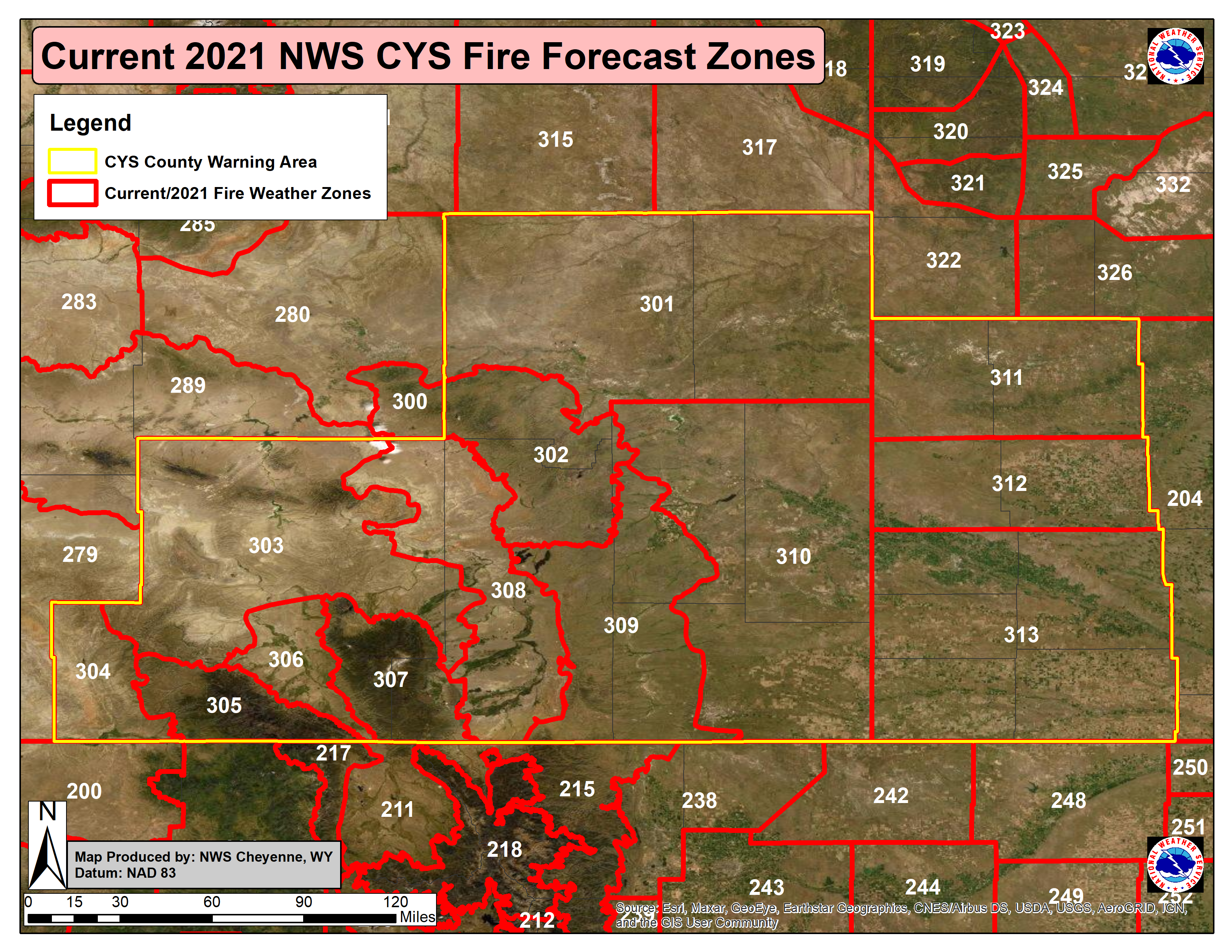
On Tuesday April 5th, 2022 at 2000 Universal Coordinated Time (UTC), the National Weather Service Forecast Office in Cheyenne, Wyoming, updated the fire weather forecast zone boundaries in Southeast Wyoming and the Western Nebraska Panhandle. Fire weather zones that will be impacted by this change will be all the current zones, including: WY301, WY302, WY303, WY304, WY305, WY306, WY307, WY308, WY309, and WY310 in Wyoming and NE311, NE312, and NE313 in Western Nebraska Panhandle. Fire weather forecast zones count will increase from the current 13 zones to a new total count of 21 zones across Southeast Wyoming (+7) and Nebraska (+1).
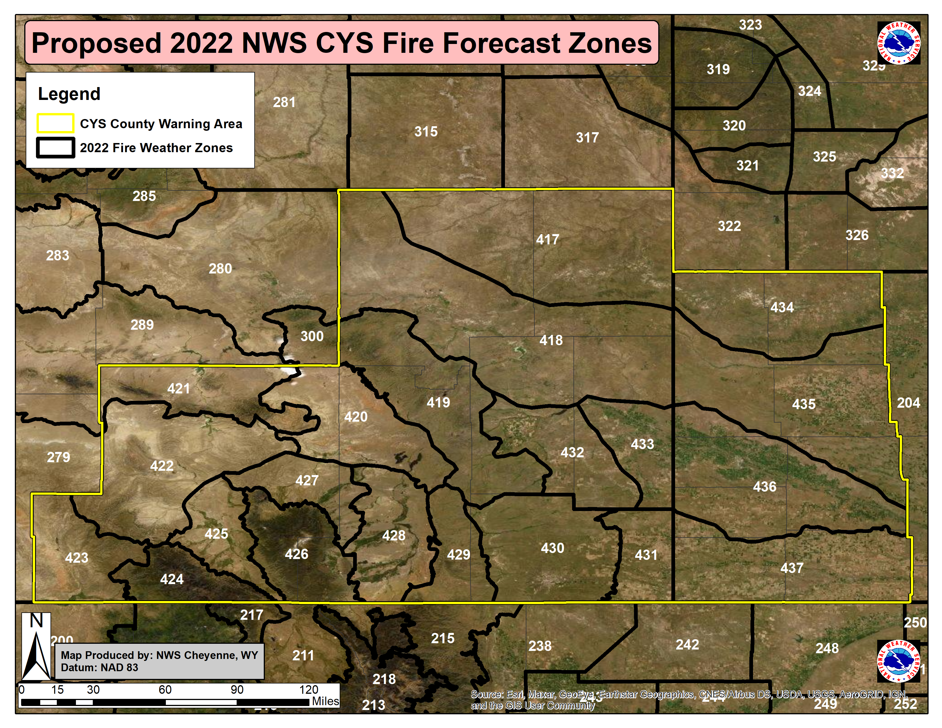
After this change, WFO Cheyenne fire weather forecast zones will better align with terrain, geo-political fire district boundaries, and geospatial coverage of fuels/landcover. Fire weather zone numbering will change as a result of the new boundaries (see images below) from 300 series to 400 series numbering system.
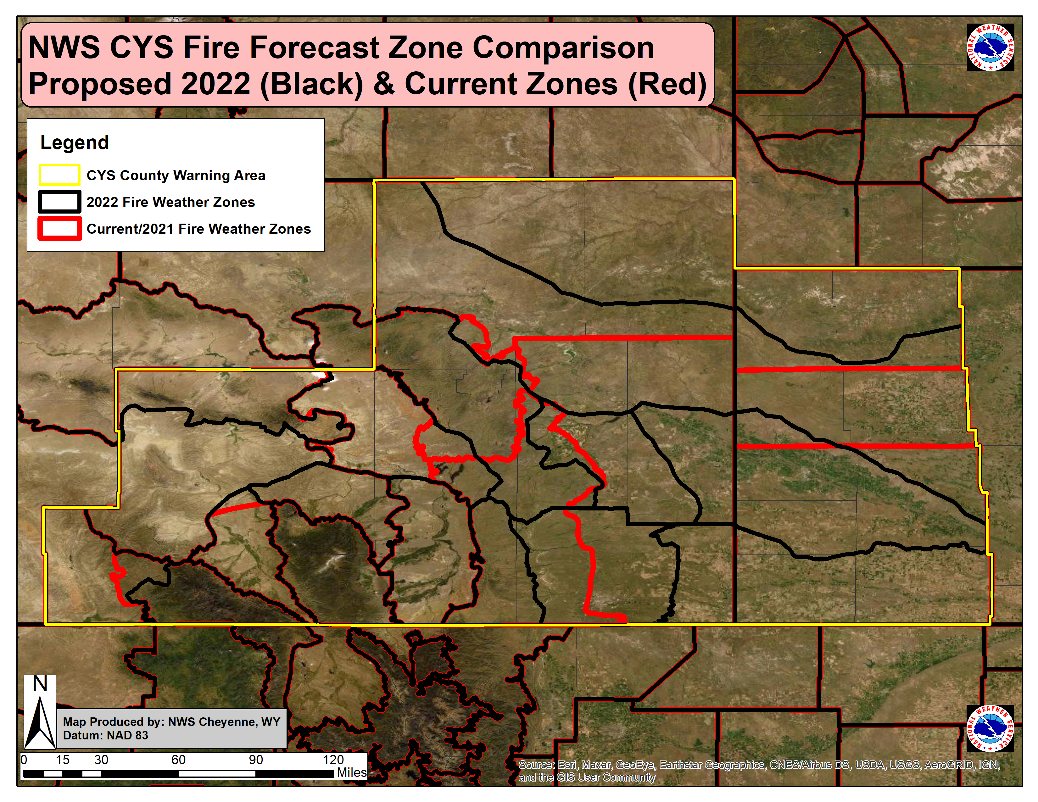
Graphical descriptions of the old and new fire weather forecast zones are available below. Current fire zone forecast maps per state can also be found here: https://www.weather.gov/pimar/FireZones. The New Fire Weather Zone Shapefiles can be downloaded here under the 22 March 2022 valid date row: https://www.weather.gov/gis/FireZones
Previous NWS Cheyenne Fire Forecast Zones (Zone Forecast Number):
Current 2022 NWS Cheyenne Fire Forecast Zones (New Forecast Zone Numbers):
Direct comparison overlay of NWS Cheyenne Current and Proposed New Fire Forecast Zones:
Reasoning Behind FWZ Changes:
Zone 417:
Follows the Wyoming side of the Pine Ridge. Winds, storm patterns, lightning starts, and relative humidity are all greatly influenced by the Pine Ridge. Winds in Niobrara and NE Converse tend to be similar to the northern Panhandle – separated zone 417 from 434 due to resource allocation between Casper Dispatch and Great Plains Dispatch. Also separated the stronger winds over Converse (zone 418) from the weaker winds over Niobrara County with differing wind climatologies.
Adjusted the western-most boundary to include all of Thunder Basin National Grassland in this zone. Fire season winds primarily southeast 19-25 mph. Vegetation: tree and herb cover.
Zone 418:
South of the Pine Ridge on the Wyoming side. Includes the area of stronger winds over Converse and the northern portion of previous zone FWZ 310 where winds are still strong. Does include the Upper North Platte River Basin. Fire season winds southeast or northwest 10-20 mph, up to 25-32 mph. Vegetation: herb cover.
Zone 419:
North and central Laramie Range, elevations 5000-7500 ft. Added areas with similar elevations and fuel type to the southeast of the North Laramie Range public zone (FWZ 309), and removed the lower elevations that have a different predominant wind and different fuel type to the west (added to zone 420). Comment from an FMO that winds and fuels drive fires off the highest elevations and towards the southeast, prompting zone 419’s expansion southeast. Zone was not expanded to the I-25 corridor in full so as to not split Wheatland in two, which works well elevation-wise. Fire season winds primarily southeast 13-19 mph, secondary north-northwest 13-19 mph. Vegetation: tree and herb cover.
Zone 420:
Lower elevation area between the Shirley Basin and the North Laramie Range (some of the lowest elevations and differing fuel types pulled out from the North Laramie Range public zone/zone 419), also known as the lower Laramie Valley. Winds here are generally stronger here than to the south (zone 428). The public zone for this area was used as a guide and included lower elevations from the north Laramie Range zone and Bordeaux public zone to it. This maintains consistency in wind, elevations and vegetation type. Fire season winds primarily northwest 25-32 mph, secondary west 25-32 mph. Vegetation: shrub cover.
Zone 421:
Seminoe/Pathfinder Dam & Higher Terrain Area - Winds here are generally stronger than areas south, especially from the west. This zone is currently the northern portion of FWZ 303. Used the public zone to draw this zone for consistency, which follows the topography/elevations well. This new zone extends naturally out of RIW’s FWZ 289. Fire season winds primarily westerly 32-39 mph. Vegetation: shrub and tree cover.
Zone 422:
Central Carbon County. Always windy, but less so than areas north and south which are now separated out. This new zone is also lower in elevation than the new zones to the north (421) and south (423). Fire season winds primarily southwest 20+ mph. Vegetation: Shrub and herb cover.
Zone 423:
Windy corner of southwest Carbon County. Expanded current FWZ 304 to include the windy and lower elevation portion of the Sierra Madres, or FWZ 305, to gain consistency between wind strength and vegetation type. Fire season winds primarily southwest 25-32 mph. Dixon observation site primarily out of the east-northeast 10-20 mph with downsloping winds off the Sierras. Vegetation: Shrub and herb cover.
Zone 424:
This zone used to be FWZ 305, the Sierra Madre Range; it is now just the higher elevations of the zone. Lower elevations were removed from the current zone and included them in zone 423. Have improved consistency in topography, wind patterns , and vegetation type. Fire season winds primarily east 13-19 mph, secondary southwest 13-19 mph. Vegetation: tree cover.
Zone 425:
The Saratoga Valley. Didn’t change much from the FWZ 306. Added a small area to the northeast side of the zone to include similar fuel types. Fire season winds tend to be weaker than surrounding areas. Primarily southeast, downvalley 10-15 mph, up to 20 mph at times. Vegetation: Shrub and herb cover.
Zone 426:
Snowy Mountains Area - Didn’t change this zone very much. Did add some of the lowest elevations along the zone’s western edge to the Saratoga zone (zone 425) to maintain consistency in topography and vegetation type.
Zone 427:
Arlington-Elk Mountain gap wind zone. Used the public zone for consistency, but added Quealy Dome observation point to it. Is primarily the eastern portion of FWZ 303, but winds are generally stronger here. Winds are generally stronger through this area, especially out of the west and southwest. Fire season winds primarily west 19-25 mph, secondary northwest. Vegetation: tree cover.
Zone 428:
Upper Laramie Valley. Higher elevations than the portion of the valley to the north, but sheltered from the west. Used the public zone for consistency. The northern portion of the zone is windier than this section to the south. Fire season winds primarily downvalley, out of the southeast 10-15 mph, up to 20+ mph. Tend to be sheltered from the west, so weaker winds here versus the lower Laramie Valley, zone 404, which is less sheltered. Secondary, northwest 10-15 mph. Vegetation: shrub and herb cover.
Zone 429:
South Laramie Range, which includes the I-80 Summit. Used the public zone for consistency. Better for vegetation type, elevation, and the strong predominant wind flow. Fire season winds primarily west 15-25 mph. Vegetation: shrub, herb and tree cover.
Zone 430:
Cheyenne Ridge Area - Winds rip here, especially when out of the west and during downslope/bora patterns. The northern boundary of Laramie County was used for bounds per partner feedback as a “natural” break to help with initial attack instructions. This zone includes the southern portion of FWZ 310 and the eastern portion of FWZ 309. Did split out zone 431 due to decreased winds as you head east and more agricultural lands. Zone includes Bear Creek and Whitaker weather stations.
Fire season winds are stronger than those to the north most of the time, especially when westerly. Fire season winds primarily northwest 10-15 mph, up to 20+ mph. Secondary, west and southwest 10-20 mph. Vegetation: herb, shrub and cultivated crop cover.
Zone 431:
Separated this zone out of Zone 430 for a few reasons: 1. Winds rarely gust as strongly on the east side of Laramie County as they do to the west, 2. Humidities tend to be lower here than across zone 430 (allows for more accurate issuance of RFWs), 3. The land is more of an agricultural landscape than in zone 430 and is actually more similar to zone 437. Would have merged zones 431 and 437 except wanted to be cognizant of resource allocation between Casper and Great Plains Dispatch centers. Fire season winds predominantly south, southeast, and less so north and northwest 10-15 mph, up to 19-25 mph. Vegetation: Predominately cultivated crops and shrub cover.
Zone 432:
High Plains wind-gap area, including Bordeaux and Chugwater. Winds are stronger here when out of the southwest rather than to the south across the Cheyenne Ridge/zone 430. This zone includes portions of FWZ 309 (lower elevations below 5kft) and FWZ 310. Flatter Plains that areas west now included in the newest iteration of zone 419. Fire season winds primarily southwest 20+ mph, secondary to the southeast 10-20 mph; though has the potential to be windy from most directions. Winds are more gusty than across the Cheyenne Ridge. Vegetation: herb cover, grasslands.
Zone 433:
Follows the Wyoming side of the North Platte River Basin. Includes portions of FWZ 310’s lower elevations. Winds and humidities greatly influenced by the North Platte River. Separated zone 418 from 435 due to resource allocation between Casper Dispatch and Great Plains Dispatch. Fire season winds predominantly southwest and east 10-15 mph, up to 19-32 mph. Vegetation: cultivated crop and shrub cover.
Zone 434:
Follows the Nebraska side of the Pine Ridge. Winds, storm patterns, lightning starts, and humidities are all greatly influenced by the Pine Ridge. Winds in Niobrara and NE Converse tend to be similar to the northern Panhandle – separated zone 417 from 434 due to resource allocation between Casper Dispatch and Great Plains Dispatch. Fire season winds primarily southeast 19-25 mph. Vegetation: tree and herb cover.
Zone 435:
West-central Nebraska Panhandle. Conditions tend to reach critical thresholds here less often than its surrounding Nebraska zones. Between natural geographical boundaries. This zone includes most of what is currently FWZ 312, plus a little from both the north and the south where winds are a bit lighter overall. Fire season winds are lighter than areas north and south. Fire season winds primarily southeast 10-15 mph, up to 20+ mph. Vegetation: shrubs and cultivated crop cover.
Zone 436:
Follows the Nebraska side of the North Platte River Basin. Includes portions of FWZ 313 and 312’s lower elevations. Winds and humidities greatly influenced by the North Platte River. Separated zone 433 from 436 due to resource allocation between Casper Dispatch and Great Plains Dispatch. Fire season winds predominantly southwest and east 10-15 mph, up to 19-32 mph. Vegetation: cultivated crop and shrub cover.
Zone 437:
Follows the I-80 corridor along the southwest portion of the NE Panhandle. Encompasses the southern portion of FWZ 313. Separated areas south of the North Platte River Basin as winds do get stronger to the south in certain scenarios, especially in mountain wave events, and relative humidity values do remain lower than along the river basin. Would have included zone 431 in zone 437, but wanted to be cognizant of resource allocation between Casper and Great Plains Dispatch.
Fire season winds predominantly south, southeast, and less so north and northwest 10-15 mph, up to 19-25 mph. Vegetation: Predominately cultivated crops and shrub cover.
Text Products
NWS watch, warning and forecast products affected by these changes are:
| Product | WMO Heading | AWIPS ID |
| NWS Cheyenne Fire Weather Watch | WWUS85 KCYS | RFWCYS |
| NWS Cheyenne Red Flag Warning | WWUS85 KCYS | RFWCYS |
| NWS Cheyenne Fire Weather Planning Forecast | FNUS55 KCYS | FWFCYS |
NWS partners and users will need to make necessary changes to their communications systems to accommodate these fire weather forecast zone changes.
A shapefile of the new fire weather forecast zones for WFO CYS is located online at: Under development
For more information, please contact:
Jared Allen - Warning Coordination Meteorologist
1301 Airport Parkway
Cheyenne, WY 82001
307-772-2468 ext. 726
Email: Jared.Allen@noaa.gov
National Service Change Notices are online at: http://www.weather.gov/os/notif.htm


 Weather Story
 Weather Map
 Local Radar