National Weather Service United States Department of Commerce

Scattered Severe Thunderstorms Across the Northern Plains; Fire Weather Concerns in the Western U.S.

Scattered severe thunderstorms are forecast across central and eastern North Dakota, as well as far northwest Minnesota Saturday (Slight Risk level 2 of 5). Damaging wind gusts are the primary threat. Elevated to critical fire weather conditions will persist through the weekend across the Western U.S. Isolated dry thunderstorms could lead to new fire starts over portions of the northern Rockies. Read More >


The Emergency Managers Weather Information Network -- EMWIN -- is a service that allows users to obtain weather forecasts, warnings, and other information directly from the National Weather Service (NWS) in almost real time. EMWIN is intended to be used primarily by emergency managers and public safety officials who need timely weather information to make critical decisions.

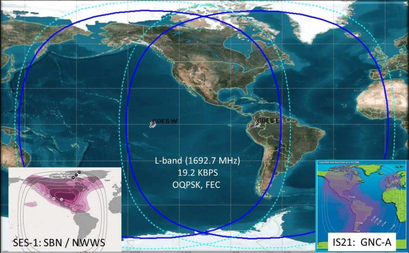
Emergency Managers Weather Information Network (EMWIN) offers an economical way to receive all products available on the NWWS, plus graphical forecasts and select satellite data. Compared to the NWWS, typically, an additional broadcast delay of 5 to 20 seconds can be expected for watches and warnings, as compared to the NWWS delay. The EMWIN system is monitored on 24 hours per day, 7 days a week, and has an estimated availability of at least 99%. EMWIN systems are available from many private industry suppliers. The service itself is free.

  • Developed in partnership with the National Oceanic and Atmospheric Administration (NOAA) National Environmental Satellite, Data, and Information Service (NESDIS), and other public and private organizations
  • Provides open public access without fee, to a managed set of US National and World Meteorological Organization (WMO) International warnings, watches, forecasts, and other products.
  • Sequences highest-priority/most-urgent products ahead of all lower priorities products
  • Supplements other US NOAA/NWS dissemination services, including:
    • NESDIS GEONETCast Americas (GNC-A) satellite broadcast service
    • NOAA Weather Wire System (NWWS) satellite broadcast and Internet services
    • SBN-NOAAPORT Broadcast System
    • NOAA Weather Radio (NWR) VHF Broadcast Service
    • NWS Information Dissemination Service (NIDS) Internet Services
    • NWS Global Telecommunication System (GTS) Internet File Service (GIFS)


GOES Satellite Footprint Extent of EMWIN Broadcast

EMWIN satellite broadcast footprint image


EMWIN Dissemination Platforms and Stakeholders

EMWIN Dissemination Platforms:

Stakeholders:

  • EMWIN, LRIT and GOES-R HRIT/EMWIN Broadcast Interface Community
    • Broadcast Receivers and Antenna Systems
  • Application Software Community
  • Information End User Communities:
    • US National Users – Government, commercial, public and private
    • WMO Regional Association IV (RA-IV) Member States
    • Adjacent WMO Regions (RA-III and RA-V; Pacific Ocean Region)