
Tropical Storm Bertha could bring tropical storm conditions to portions of the Florida Panhandle and Alabama coast through Wednesday, where a Tropical Storm Watch and Storm Surge Watch is in effect. Numerous severe thunderstorms with heavy rainfall are expected from the Ohio Valley into the Mid-Atlantic and Northeast Tuesday. Read More >
A SEVERE WEATHER CLIMATOLOGY FOR THE EL PASO, TEXAS
NATIONAL WEATHER SERVICE OFFICE COUNTY WARNING AREA
James A. Reynolds
National Weather Service
El Paso, Texas
1. INTRODUCTION
As of this writing, the El Paso, Texas NEXRAD Weather Service Office (NWSO) continues to progress toward a Stage II classification of the National Weather Service's Modernization and Restructuring (MAR) at which time the office will be considered a Weather Forecast Office (WFO). Already, a full compliment of Senior Forecasters has been chosen to staff the El Paso office, and the office has assumed full forecast and warning responsibility for an area defined as its County Warning Area (CWA). The Advanced Weather Interactive Processing System (AWIPS) has been installed for nearly a year, and when AWIPS is commissioned in the summer of 2000, the office will finally attain WFO status.
Severe weather has a marked effect on the El Paso CWA, especially during the summer months between June and September. This climatology was created in an effort to quantitatively define the severe weather threat that new and existing forecasters in the El Paso office will encounter. It is assumed that an increased understanding of the local climatology will lead to more accurate forecasts and warnings. The National Weather Service defines a severe thunderstorm as that which has the occurrence of one or more of the following: tornado, hail greater than or equal to 0.75 inches in diameter, convective wind gust greater than or equal to 50 knots, or convective wind damage. Gradient winds which produce winds gusts of 50 knots or greater also have a significant impact on the El Paso CWA mainly during the winter and spring seasons, and these occurrences will also be explored in this publication. All of these elements will be analyzed separately in later sections.
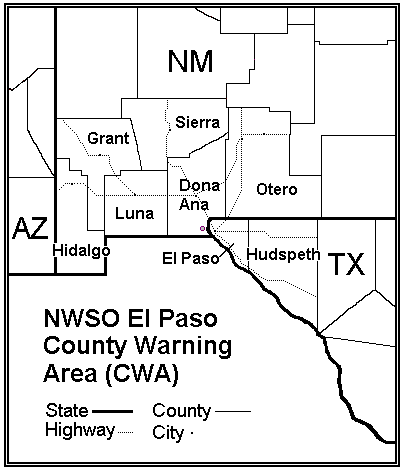
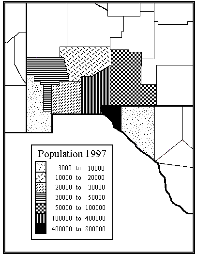
Fig. 1 shows the El Paso CWA which encompasses six counties in southwestern and southcentral New Mexico, and two counties in far west Texas. The greater population centers and most major highways are also denoted. Fig. 2 shows the population of the individual counties contained within the El Paso CWA. Except for the city of El Paso, and a handful of lesser population centers, the El Paso CWA is highly rural in nature. Because of this fact, it is believed that only about one-third of all occurrences of severe weather or damage created by severe weather are actually reported. This number has slowly been increasing over the past few decades as people continue to spread out around the area and move into once unpopulated areas .
2. DATA
The data used in this climatology were derived from various sources which yielded a 43-year database record between the years 1955 through 1997. The SVRPLOT program (Hart, 1993), which utilizes a database of severe weather events collected by the National Severe Storms Forecast Center (NSSFC), was used to generate the graphics which detail where individual severe weather elements were reported within the El Paso CWA. The NSSFC's data base contains tornado occurrences from 1950-1995; however, hail and wind events are only available from 1955 to 1995. Hail and wind data were not available through the SVRPLOT program for 1972 so information from the Storm Data publication (NOAA, 1998) was used to fill in this gap. Monthly issues of Storm Data were also reviewed to seek out additional severe weather occurrences that might not have been placed into the SVRPLOT program. Other data were obtained from a separate severe weather database created by WFO Albuquerque, and from the National Climatic Data Center. Data for 1996 and 1997 were acquired directly from the local Warning Coordination Meteorologist.
3. Tornado Climatology
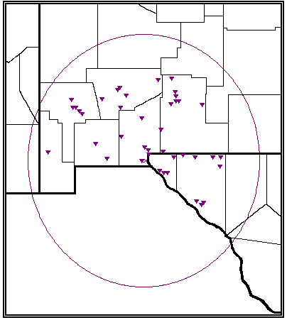
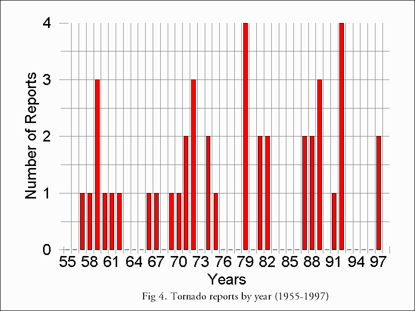
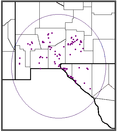
Fig. 3 is a plot of the 42 tornadoes reported within the El Paso CWA between 1955-1997 which equates to about 1 tornado a year. These findings are similar to results noted in a Western Region Technical Attachment (Green et al., 1996) in regard to the occurrence of tornadoes in the Phoenix metropolitan area. This comes as no surprise considering the similar weather regimes that the two regions share as discussed by Reynolds (1998). The circle drawn around and somewhat exceeding the CWA delineates the 124 nautical mile range/0.54 nautical mile resolution of the El Paso Doppler weather radar (WSR-88D). It is interesting to note that nearly a third of the area covered by this range is over Mexico. In accordance with the population pattern discussed earlier, it can be seen that while tornadoes have been reported all around the CWA, the bulk of tornadoes have been reported near the larger population centers. The yearly frequency of tornadoes (Fig. 4) does not show an increasing trend as might be expected over an area that has become increasingly populated. Instead, it appears that occurrences of tornadoes fall into clusters of years with as many as four consecutive years passing by between clusters without a single tornado being reported.
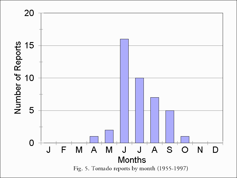
Fig. 5 which shows the monthly tornado frequency, indicates a somewhat skewed normal distribution curve. Tornadoes have been reported from April to October with no tornadoes reported from November to March. Tornado activity is at its peak in June with a decreasing number of events each month thereafter through September. Relatively fewer tornadoes are reported in April, May and October during the transition into and out of the main convective season.
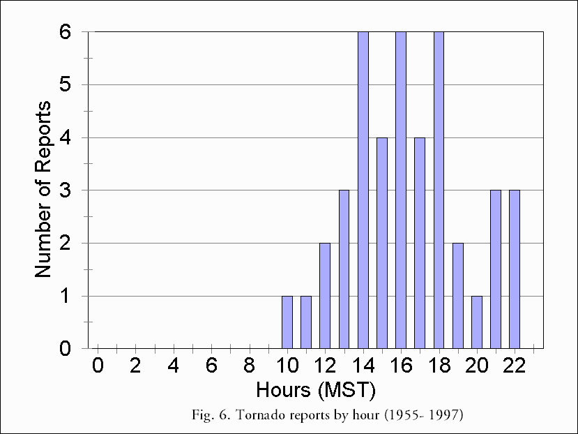
The hourly frequency of tornadoes (Fig. 6) shows that reported tornado occurrences are limited to the hours between 1000-2300 MST with just less than two-thirds of all reports occurring between 1400-1900 MST . The hourly distribution is bimodal with a secondary but smaller increase in tornado reports near the very end of the day. The median time of tornado occurrence is 1615 MST. This time was very similar to that of the 1600 MST peak occurrence of lightning over all of New Mexico (Fosdick and Watson, 1995).
Two of the 42 tornado occurrences were classified with a strength of F2 on the Fujita scale while the remaining cases were of the F0 and F1 variety. To date, no F3 or stronger tornadoes have occurred in the El Paso CWA. Generally, tornadoes are short lived with short path lengths and narrow path widths. To date, no fatalities associated with tornado occurrences in the CWA have been reported.
4. SEVERE HAIL CLIMATOLOGY (>0.75 INCH)
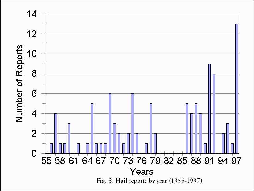
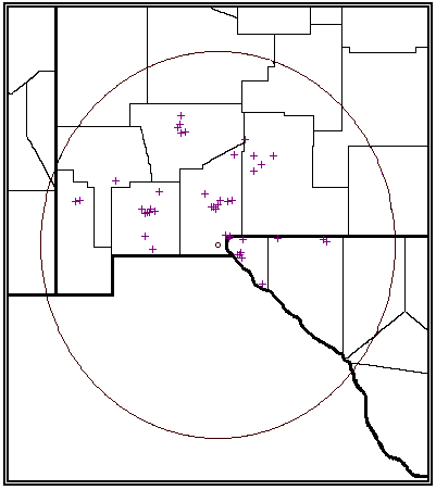
Fig. 7 depicts the areal distribution of the 105 severe hail events reported in the El Paso CWA between 1955-1997. The average number of severe hail events per year is 2.4. As with tornado occurrences, severe hail has been reported over many areas of the CWA but is most often reported near the greater population centers. Fig. 8 shows the yearly frequency of severe hail reports. Yearly severe hail reports from 1956-1979 were fairly steady with a small increase over time. Reports of severe hail in the CWA abruptly ended in 1980 and did not resume again until 1986. While severe hail was most certainly produced somewhere in the CWA between 1980-1985, it is most likely that weather patterns during those years were not conducive to the formation of severe hail that was widespread enough to be reported. From 1986-1997, severe hail reports show an increasing trend over time. Almost half of all severe hail events reported in the CWA occurred during this 12 year time period with an average occurrence of 4.6 events a year. This is considerably higher than the yearly average of two events between the years of 1955-1979. The higher yearly average occurrence of severe hail can best be attributed to the implementation of a verification system of severe storms by the National Weather Service beginning in 1980 as described by Hales (1993). The implementation of this program prompted NWS offices to place more emphasis on seeking out severe weather reports during and after severe weather events. The year 1997 had the greatest number of hail reports for any year (13), over a third of which occurred during the severe weather outbreak of June 7.
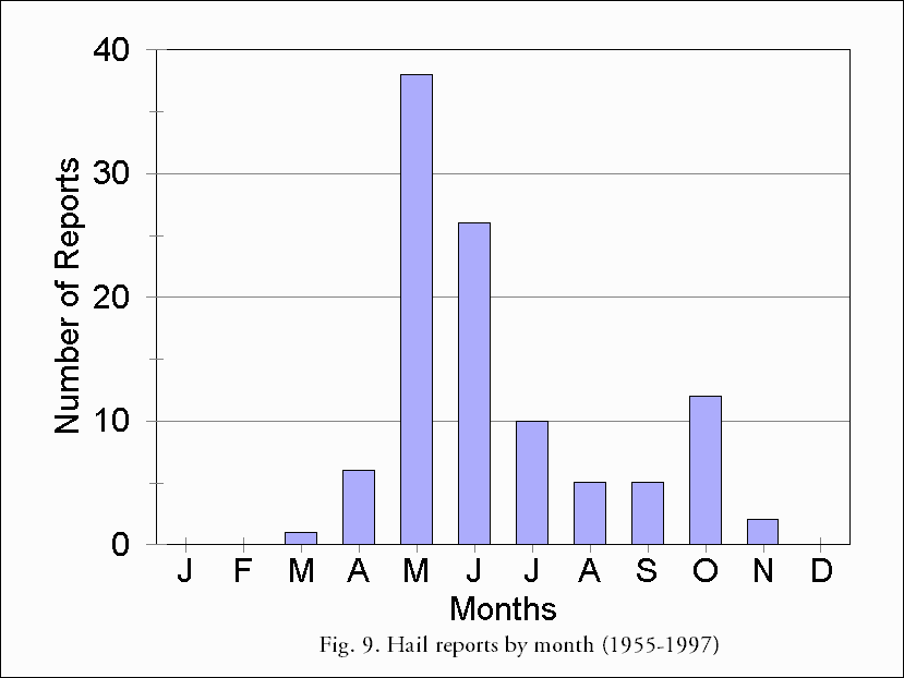
The monthly frequency of severe hail reports (Fig. 9) shows a primary peak in May and June with a secondary maximum in October. No severe hail has been reported in January, February, and December. Different severe weather climatologies use differing methods to categorizing hail sizes; however, the classification scheme used in this study differs from the one used by Kelly et al. (1985) which breaks hail into two categories (2 inches or less and greater than 2 inches). In this study, severe hail was broken down into 3 categories: 1. large (0.75-1.24 inch in diameter), 2. giant (1.25-1.99 inch in diameter), and 3. enormous (>2.00 inch in diameter). Fig. 10 shows the monthly severe hail size distribution for the El Paso CWA. While severe hail has been reported from March through November, enormous hail has only been reported in May, June, and October, which are the transition months into and out of the main convective season. The occurrence of enormous hail during these months is likely due to a sufficient amount of convective available potential energy present coupled with transient cold fronts that lend the needed instability to raise moisture well above relatively low freezing and wet-bulb zero levels. The proximity of upper level jets to the area may also play a role in severe hail formation. Fig. 11 shows the diurnal frequency of severe hail events which is distributed normally. The median time of hail occurrence is 1600 MST which is only 15 minutes earlier than that of tornadoes, but identical to the peak occurrence of lightning over New Mexico (Fosdick and Watson, 1995).
5. SEVERE CONVECTIVE AND GRADIENT WIND CLIMATOLOGY (>50 knots)
As mentioned in the introduction, the El Paso CWA is affected by severe convective wind events, and also to a large extent, by severe gradient wind events. Severe weather climatologies do not normally address the impacts of severe gradient wind events on particular areas, however these types of events happen frequently enough over the El Paso CWA to warrant an examination of their occurrences.
Between 1955-1997, 51 severe convective wind events were identified as were 34 severe gradient wind events. Fig. 12 is a plot of where severe winds or damage resulting from these winds has been reported in the El Paso CWA. This plot was originally produced using severe convective wind events contained in the SVRPLOT program (Hart, 1993) with locations of damage reported from severe gradient winds events added to this. It should be noted that individual symbols for reported severe wind events (crosses) sometimes represent multiple events. Reports of severe winds and damage associated with them are even more confined to the more dense population centers than tornadoes and hail. Most likely this is due to the fact that tornadoes and hail can be spotted anywhere while damage from wind events is most pronounced in population centers where greater concentrations of manmade structures exist.
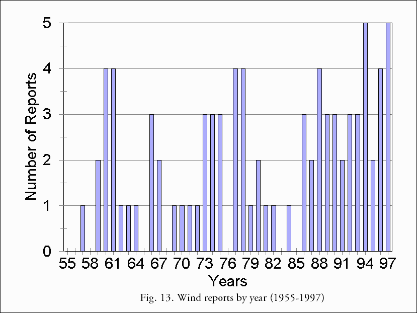
The combined yearly frequency of both convective and gradient severe wind events is shown in Fig. 13. The data in this graph are similar to the yearly distribution of severe hail. Like severe hail, about 1 severe wind event was recorded per year up until the late 70s and early 80s with some years having three or four. Few severe wind events were reported in the early to mid 80s. Severe wind events picked up again in 1986 and generally increased in yearly occurrence through 1997. From 1955 to 1984, just over 50% of the severe wind events occurred in the CWA with an average of 1.53 wind events per year. This average is lower than the 3.25 yearly average of severe wind events found between 1986-1997. Again, this is most likely due to the more vigorous investigation of weather related damages by the NWS beginning in 1980 (Hales).
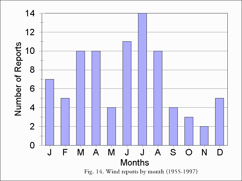
The monthly frequency of severe wind event reports as shown in Fig. 14, exhibits a bimodal distribution. The primary peak from June to August is associated with the main summer convective season and the secondary maximum during March and April occurs in association with strong gradient patterns over the CWA which are common in the spring season. Severe wind events that occurred between May and October were always a result of convective activity. Severe wind events that occurred between November and April were generally a result of strong gradient patterns over the CWA, with a very small number of these events stemming from convective activity.
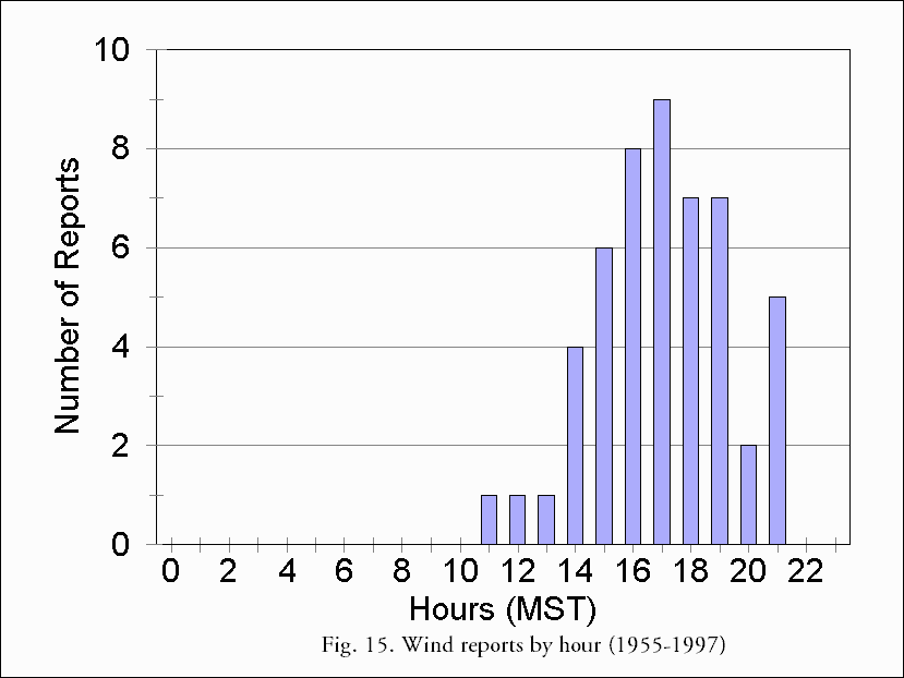
In determining the diurnal distribution of wind events, only severe convective wind events were used. As expected, because of the NWS definition of severe thunderstorms, severe gradient wind events are not included in the SVRPLOT program (Hart, 1993). Therefore, it was only possible to ascertain the times of peak severe gradient wind occurrences by reviewing each individual Storm Data publication (NOAA, 1998) within the time frame of this study. Severe gradient wind events last over several hours and are reported as such in Storm Data with the times of occurrences of peak gusts rarely recorded. However, severe gradient winds typically attain their peak during the mid to late afternoon. The diurnal distribution of severe convective wind events is a normal distribution (Fig. 15) much like that of tornadoes and hail. The median time of occurrence of severe convective winds is 1715 MST. This is 60 to 75 minutes later than that of tornadoes and tornadoes, respectively.
6. CONCLUSIONS
Much as anticipated, the temporal distribution of severe weather in the El Paso CWA does, indeed, indicate a main "severe weather" season. While severe weather can occur during any month of the year in the area, most severe weather occurs from June through September. In a departure from typical severe weather climatologies, severe gradient wind events, as well as severe convective wind events, were analyzed.
It is hoped that this climatology will lead to a better understanding of the occurrence of severe weather in the El Paso CWA, which will, in turn, lead to improved forecasts and warnings. The data contained within this study should also benefit local weather spotters, as well as emergency managers, or anyone else seeking more information about the particulars of severe weather in southwestern and south central New Mexico, and far west Texas.
7. ACKNOWLEDGMENTS
Thanks to Val J. MacBlain, NWSO El Paso for providing suggestions that led to the development and improvement of this technical memorandum. Thanks to John Hart for initial assistance in manipulating the SVRPLOT program. Thanks also to Dierdre Kahn and Roy Pennington, WFO Albuquerque, and Dave Martin, WFO Fort Worth for their assistance in weather data acquisition. Certain wind data provided on request from the National Climatic Data Center.
8. REFERENCE
Census, U. S. Bureau of, cited 1998: [Available on-line from www.census.gov/population/www/estimates/co_98_1.html]
Fosdick, E. K., and A. I. Watson, 1995: Cloud-to-Ground Lightning Patterns in New Mexico During the Summer. Nat. Wea. Dig., Vol. 19, Num 4, 17-24
Hales, John E., 1993: Biases in the Severe Thunderstorm Database: Ramifications and Solutions. Preprints, 13th Conf. Wea. Forecasting and Analysis, Vienna, VA, Amer. Meteor. Soc., 504-507
Green, G. D., D. Mitchell, and J. A. Haro, 1996: Mini Supercell Interaction: The February 13, 1995 Mesa Tornado. [Available on-line from www.wrh.noaa.gov/wrhq/96TAs/TA9632/ta96-32.html]
Hart, J .A., 1993: SVRPLOT: A New Method of Accessing and Manipulating the NSSFC Severe Weather Database. Preprints, 17th Conf. on Severe Local Storms, St. Louis, Amer. Meteor. Soc., 20-24.
Kelly, D.L., J. T. Schaefer, and C. A. Doswell, III, 1985: Climatology of Nontornadic Severe Thunderstorm Events in the United States. Mon Wea. Rev., 113, 1997-2014.
National Oceanic and Atmospheric Administration, cited 1998: Storm Data, National Climatic Data Center, Asheville, North Carolina
Reynolds, J. A., 1998: Some Surface Dry Bulb and Dew Point Temperatures Associated With Convective Thunderstorms in El Paso, Texas. El Paso Local Study [Available on-line from Convective Thunderstorms in El Paso, Texas. El Paso Local Study]

