Overview
A National Weather Service storm damage assessment team completed a survey of the Warroad community and affected rural areas across eastern Roseau and western Lake of the Woods counties. Ground tracks, photographic and video evidence, and eyewitness reports indicate that at least three additional distinct tornadoes occurred along an approximate 19 mile arching path beginning about 8 miles WNW of Warroad around 641 pm, through the community of Warroad around 704 to 712 pm, to about 3 miles NNE of Roosevelt around 740 pm. All of these tornadoes were generated by the same parent supercell thunderstorm which also spread heavy rains and hail up to softball size from the ROSEAU port of entry at MN HWY 310 past the community of Baudette and MN Hwy 72. This survey resulted in confirmation of the strongest tornado, an F3, on August 5, 2006 in the Warroad, Minnesota area to date. Reportedly there were no significant injuries or fatalities since the campground had been largely evacuated by the Warroad Police Department in advance of the tornado.
Additional tornado damage tracks were still being analyzed with civil air patrol flights and ground evidence after the storm damage survey was completed, resulting in confirmation of at least 3 additional weak tornadoes occurring in portions of Ransom, Richland, and Cass counties in North Dakota and several other tornadoes in Roseau and Lake of the Woods counties in Minnesota.
Tornadoes:
|
Tornado #1 - Warroad MN
|
||||||||||||||||
The Enhanced Fujita (EF) Scale classifies tornadoes into the following categories:
| EF0 Weak 65-85 mph |
EF1 Moderate 86-110 mph |
EF2 Significant 111-135 mph |
EF3 Severe 136-165 mph |
EF4 Extreme 166-200 mph |
EF5 Catastrophic 200+ mph |
 |
|||||
Wind & Hail:
The largest hail was reported at 658 pm CDT at 2 miles WNW Warroad in Roseau County, MN at up to 4 inches in diameter, associated with an isolated supercell thunderstorm. Hail up to 2 1/2 inches in diameter was reported with isolated supercell thunderstorms in Richland County, ND. Tree damage was also reported with this activity. See the Storm Reports section for detailed information.
Storm Reports
Tornadoes reported in Storm Prediction Center archive from this date include:
1. An F3 tornado tracking east by southeast for nearly 3 miles across the northern part of Warroad, MN.
2. Another tornado in a series with #1 appears to have had an intermittent track for nearly 7 miles, with debris fallout from the Warroad area along and east.
3. A tornado tracked for at least 10 miles into Beltrami Island State Forest south of Winner and Norris Camp. Snapped and uprooted trees were noted for a path up to 100 yards in width.
4. A weak tornado tracked east by southeast into Richland County (ND) about 10 mi E of Sheldon around 713 pm. The tornado tore down numerous tree branches in shelter belts.
5. A weak tornado tracked southeast and cross into Richland County (ND) 3 mi ESE of Leonard by 735 pm. The tornado knocked down or uprooted several trees.
6. A weak tornado tracked intermittently to the west end of Mooreton (ND) by 847 PM. A few large trees were toppled along the path. Peak winds estimated at 70 mph.
Storm Reports from that Date include:
NWUS53 KFGF 060422
LSRFGF

PRELIMINARY LOCAL STORM REPORT...SUMMARY
NATIONAL WEATHER SERVICE EASTERN ND/GRAND FORKS
1122 PM CDT SAT AUG 05 2006

..TIME...   ...EVENT...      ...CITY LOCATION...     ...LAT.LON...
..DATE...   ....MAG....      ..COUNTY LOCATION..ST.. ...SOURCE....
            ..REMARKS..

0600 PM     HAIL             9 N ROSEAU              48.98N 95.76W
08/05/2006  E0.75 INCH       ROSEAU             MN   LAW ENFORCEMENT

0610 PM     HAIL             2 S PINECREEK           48.95N 95.94W
08/05/2006  E1.75 INCH       ROSEAU             MN   PUBLIC

0620 PM     HAIL             5 E FISHER              47.80N 96.69W
08/05/2006  E0.75 INCH       POLK               MN   PUBLIC

0622 PM     HAIL             5 NW CROOKSTON          47.83N 96.68W
08/05/2006  E0.75 INCH       POLK               MN   PUBLIC

0635 PM     HAIL             10 WNW WARROAD          48.96N 95.52W
08/05/2006  E2.50 INCH       ROSEAU             MN   TRAINED SPOTTER

            HAIL SHATTERED CAR WINDSHIELD.

0635 PM     HAIL             HUOT                    47.87N 96.42W
08/05/2006  E0.75 INCH       RED LAKE           MN   PUBLIC

0641 PM     TORNADO          3 NE SALOL              48.90N 95.52W
08/05/2006                   ROSEAU             MN   TRAINED SPOTTER

0645 PM     TORNADO          10 WNW WARROAD          48.96N 95.52W
08/05/2006                   ROSEAU             MN   TRAINED SPOTTER

            MULTIPLE FUNNELS ASSOCIATED WITH STORM.

0645 PM     HAIL             5 NE SALOL              48.92N 95.49W
08/05/2006  E1.75 INCH       ROSEAU             MN   PUBLIC

0710 PM     TORNADO          WARROAD                 48.91N 95.32W
08/05/2006                   ROSEAU             MN   TRAINED SPOTTER

            SIXTEEN SEMI-TRAILERS OVERTURNED AT MARVIN WINDOWS
            FACTORY. CAMPERS AND BOATS OVERTURNED. SWIMMING POOL
            DESTROYED.

0720 PM     HAIL             17 N GRYGLA             48.55N 95.62W
08/05/2006  E2.75 INCH       ROSEAU             MN   TRAINED SPOTTER

            BASEBALL HAIL AT THE BORDER OF ROSEAU, MARSHALL AND
            BELTRAMI COUNTIES

0720 PM     HAIL             21 NW FOURTOWN          48.50N 95.66W
08/05/2006  E2.75 INCH       MARSHALL           MN   TRAINED SPOTTER

            BASEBALL HAIL AT THE BORDER OF ROSEAU, MARSHALL AND
            BELTRAMI COUNTIES

0720 PM     HAIL             4 WNW BARRIE            46.60N 97.20W
08/05/2006  M1.25 INCH       RICHLAND           ND   TRAINED SPOTTER

0720 PM     HAIL             SKIME                   48.55N 95.60W
08/05/2006  E2.75 INCH       ROSEAU             MN   TRAINED SPOTTER

            BASEBALL HAIL AT BORDER OF ROSEAU...MARSHALL AND BELTRAMI
            COUNTIES.

0724 PM     HAIL             8 N ROOSEVELT           48.92N 95.10W
08/05/2006  E1.75 INCH       LAKE OF THE WOODS  MN   STORM CHASER

0725 PM     HAIL             4 WSW BARRIE            46.55N 97.20W
08/05/2006  M2.50 INCH       RICHLAND           ND   TRAINED SPOTTER

0726 PM     HAIL             2 N WARROAD             48.94N 95.32W
08/05/2006  E2.00 INCH       ROSEAU             MN   TRAINED SPOTTER

0735 PM     TSTM WND DMG     ARNESEN                 48.96N 95.07W
08/05/2006                   LAKE OF THE WOODS  MN   TRAINED SPOTTER

            4-6 INCH BRANCHES DOWN

0745 PM     HAIL             LONG POINT              48.98N 94.96W
08/05/2006  E0.88 INCH       LAKE OF THE WOODS  MN   TRAINED SPOTTER

0803 PM     TSTM WND GST     COLFAX                  46.47N 96.87W
08/05/2006  E60.00 MPH       RICHLAND           ND   STORM CHASER

0820 PM     TSTM WND DMG     4 ESE BORUP             47.16N 96.43W
08/05/2006                   NORMAN             MN   PUBLIC

            3-FOOT DIAMETER TREE DOWN

0820 PM     HAIL             4 ESE BORUP             47.16N 96.43W
08/05/2006  E0.75 INCH       NORMAN             MN   PUBLIC

0820 PM     TSTM WND DMG     6 NE FELTON             47.14N 96.41W
08/05/2006                   CLAY               MN   PUBLIC

            3-FOOT DIAMETER TREE DOWN

0820 PM     HAIL             6 NE FELTON             47.14N 96.41W
08/05/2006  E0.75 INCH       CLAY               MN   PUBLIC

0825 PM     TSTM WND DMG     BAUDETTE                48.71N 94.59W
08/05/2006                   LAKE OF THE WOODS  MN   TRAINED SPOTTER

            FIVE INCH DIAMETER TREES SNAPPED OFF.

0825 PM     HAIL             TWIN VALLEY             47.26N 96.26W
08/05/2006  E0.88 INCH       NORMAN             MN   PUBLIC

0840 PM     HAIL             3 E MAHNOMEN            47.31N 95.91W
08/05/2006  E0.75 INCH       MAHNOMEN           MN   TRAINED SPOTTER

0845 PM     FUNNEL CLOUD     2 N MOORETON            46.30N 96.88W
08/05/2006                   RICHLAND           ND   TRAINED SPOTTER

            WELL DEVELOPED FUNNEL VIEWED FROM INTERSTATE 29 TO
            NORTHWEST OF THE MOORETON SCALES.
Environment
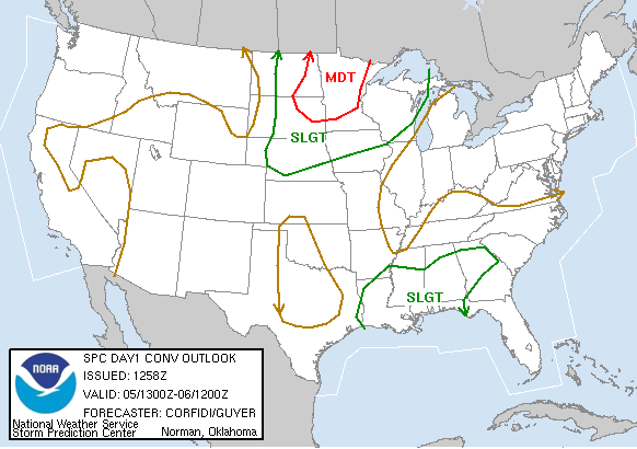
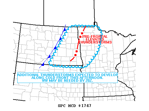
SPC Outlook and Watch Products:
 |
 |
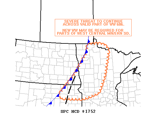 |
| SPC Day 1 Convective Outlook | SPC Mesoscale Discussion (1747) | SPC Mesoscale Discussion (1752) |
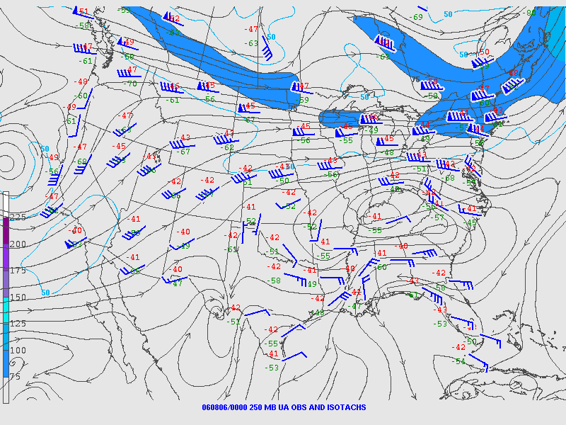
Near-storm environment summary:
 |
 |
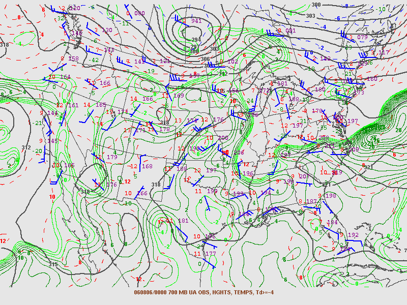 |
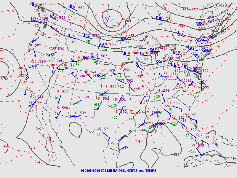
| 7 PM 250 mb Chart | 7 PM 500 mb Chart | 7 PM 700 mb Chart |
 |
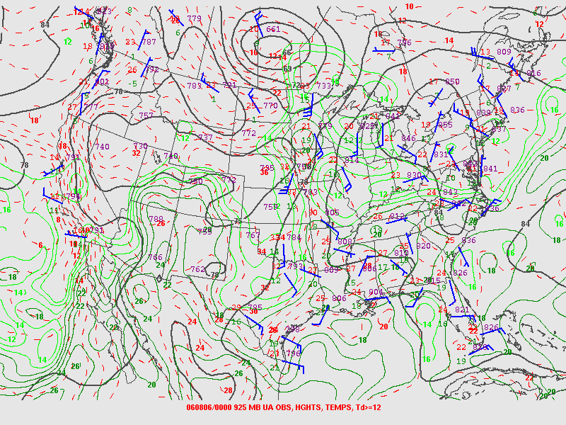 |
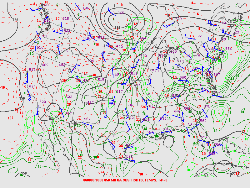
| 7 PM 850 mb Chart | 7 PM 925 mb Chart |
Additional SPC Products:
 |
 |
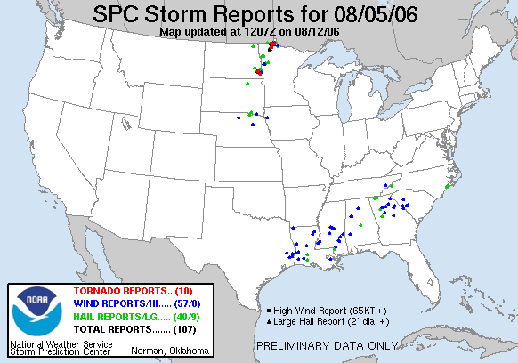 |
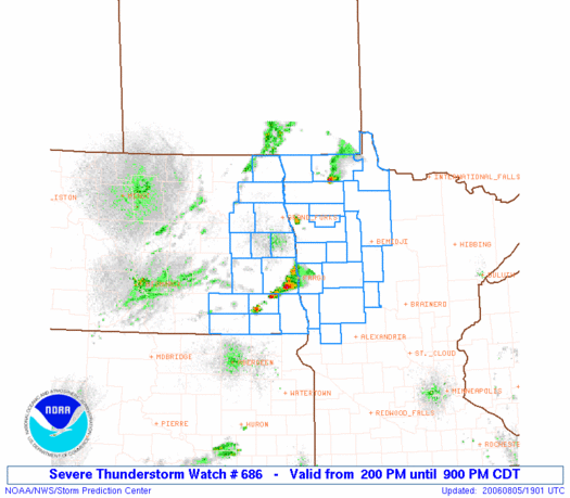
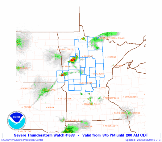
| SPC Severe Thunderstorm Watch #0686 | SPC Severe Thunderstorm Watch #0688 | SPC Storm Reports from August 5, 2006 |
 |
Media use of NWS Web News Stories is encouraged! Please acknowledge the NWS as the source of any news information accessed from this site. |
|

