Top News
Blizzard of '66
One of the most severe blizzards on record to impact the Northern Plains occurred 50 years ago between March 2-5 of 1966. The blizzard was particularly memorable for its long duration, as well as for its very heavy snowfall totals of 20 to 30 inches in some locations and wind gusts exceeding 70 mph at times. Snowfall totals reached as high as 38 inches, with drifts 30 to 40 feet high in some locations.
Nine people were killed across North Dakota (5) and Minnesota (4) on account of the blizzard, another 10 people died in South Dakota. A few of the fatalities were from overexertion from shoveling snow, while other deaths occurred as a result of becoming disoriented while out in the treacherous blizzard conditions. In addition, tens of thousands of livestock perished in the storm.
Transportation became impossible, with schools and businesses shut down across the area, and power and telephone service outages which lasted for many days.
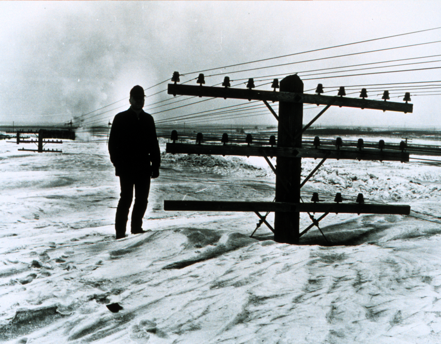
The iconic photo of North Dakota DOT employee, Bill Koch (below), standing next to a set of power lines, was taken by fellow ND DOT employee Ernest Feland on 9 March 1966. This photo and many others which were taken by Bill and Ernest in the days following the storm are available in the North Dakota State Historical Society and NOAA/NWS archives.
Meteorological Synopsis
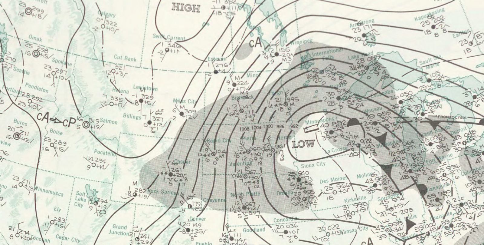
An intense "Colorado Low" weather system lifted into eastern South Dakota early on March 3, 1966, and slowly progressed into central Minnesota on March 4. These type of weather systems are capable of producing very heavy precipitation, as abundant moisture can be transported northward ahead of the strong low pressure systems. With cold enough temperatures, heavy snow and very strong winds often occur to the northwest of the track of the low pressure system, as was the case with this blizzard.
Snow began in southern North Dakota during the morning of March 2, and spread northward into March 3. At Fargo, the visibility remained one quarter mile or less for over 30 consecutive hours from March 3-5, coinciding with strong northerly winds gusting frequently over 40 or 50 mph.
Unlike many of the "killer blizzards" which had previously occurred in the Northern Plains [Schoolhouse Blizzard, 11-12 Jan 1888; Armistice Day Blizzard, 11 Nov 1940; and Ides of March Blizzard, 14-15 Mar 1941], temperatures were relatively mild during much of this blizzard. At Fargo, temperatures held steady in the 20s during the start of the blizzard, falling into the teens during the height of the blizzard, when winds were strongest and visibility lowest. By the time the blizzard was winding down, temperatures had dropped into the single digits.
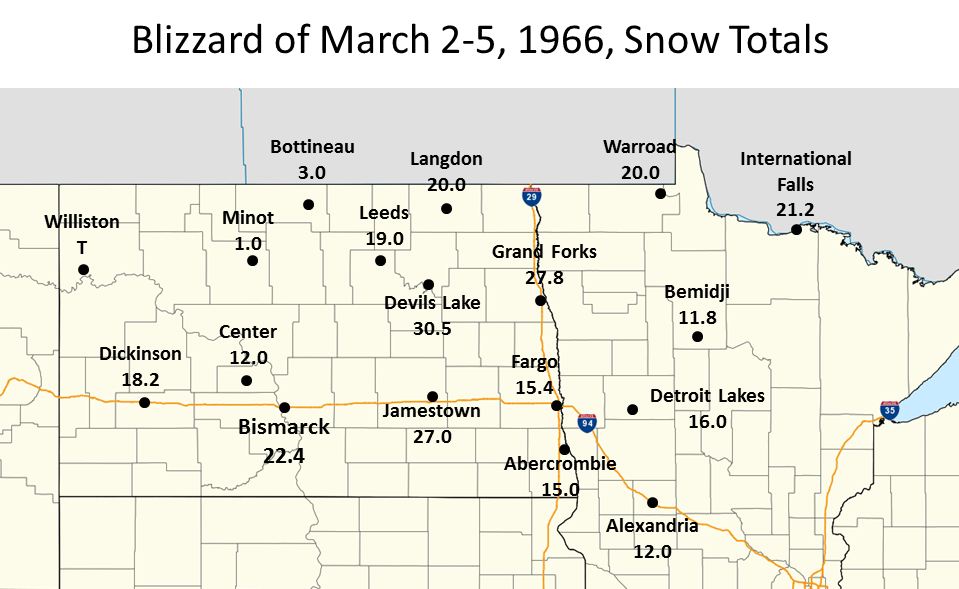
At Grand Forks, 27.8 inches of snow was measured, with the heaviest snow falling on March 4, when 17.0 inches fell. For Grand Forks, the 17.0 inches on March 4 set a record for most snowfall during one calendar day, while the 27.8 inches for the blizzard as a whole still remains the heaviest event total snowfall on record in Grand Forks.
Finally by later on March 5, the low pressure system began to move away, with winds subsiding, and colder subzero temperatures moving into the region. Below is the surface weather map valid at 12 a.m. on March 4th, 1966.
Snowfall Totals
Additonal Blizzard of 1966 Stories:
For additional stories about the Blizzard of 1966, check out these recent Grand Forks Herald articles...
- Main Article: https://www.grandforksherald.com/news/region/3957953-1966s-deadly-blizzard-was-monster
- Highlights: https://www.grandforksherald.com/news/region/3958101-highlights-1966-blizzard
A comparison of the Blizzard of March 1966 with the Blizzard of January 1996 is contained in the the NWS publcation
"Fargo, North Dakota Climate" https://climate.umn.edu/pdf/fargo_climate.pdf , by Vincent and Nancy Godon.
A summary of the official Storm Data publication regarding this event can be found here:
https://www.weather.gov/fgf/blizzardof66_stormdata
SkyWarn Spotter Class Schedule
 |
|
| Severe Weather Awareness Weeks in 2016 | |
|---|---|
| MINNESOTA: April 11-15, TOR Drill Apr 14 | N. DAKOTA: Apr 25-29. TOR Drill Apr 27 |
| Download NEW Field Guide: | Weather Spotter's Field Guide |
| Take FREE Online Courses: | Role of the SkyWarn Spotter |
| SkyWarn Spotter Convective Basics |
|
2015 Spotter Training Sessions Updated as of: Feb 26, 2016. |
|||||||||||||||||||||||||||||||||||||||||||||||||||||||||||||||||||||||||||||||||||||||||||||||||||||||||||||||||||||||||||||||||||||||||||||||||||
|
|
|||||||||||||||||||||||||||||||||||||||||||||||||||||||||||||||||||||||||||||||||||||||||||||||||||||||||||||||||||||||||||||||||||||||||||||||||||
 |
For further information concerning our warning program at The National Weather Grand Forks, please contact: Greg Gust, Warning Coordination Meteorologist. |
Frequently Asked Questions About SkyWarnWhat is SKYWARN?
|
| Area Contacts for SkyWarn or Amateur Radio Information |
|
Contact your local County Emergency Manager in North Dakota or in Minnesota for location and time of the SKYWARN training in your county this spring. For additional information on the SKYWARN program, contact Gregory.Gust@noaa.gov The National Weather Service will typically issue a warning for one or both of the following reasons; Doppler radar detects severe weather or SKYWARN spotters report severe weather. If a warning is issued for your location, you are in danger and need to seek shelter. The biggest supporters of the SKYWARN program are emergency response officials and amateur radio operators. One of the best ways to get involved is to talk with an amateur radio operator. If you have a scanner, tune in to a local amateur radio SKYWARN net (see list below) to get a feel for what is involved. |
| Amateur Radio SKYWARN Frequencies in: | |
|---|---|
Northwest Minnesota
|
|
Eastern North Dakota
|
|
|
Most of these sites can be linked together. In times of severe weather, this "link" allows amateur radio operators at the NWS in Grand Forks to communicate with those directly affected by the storm. The callsign for the NWS in Grand Forks is N0GF. Amateur radio operators are a vital part of the NWS severe weather warning program. Amateur Radio Clubs
Amateur Radio Links |
 |
Media use of NWS Web News Stories is encouraged! Please acknowledge the NWS as the source of any news information accessed from this site. |
|

