Overview
Scattered rain showers and some isolated thunderstorms spread across portions of the Red River Valley region, targeting the southern valley and specifically Ransom, Sargent, and Richland counties in southeast North Dakota. Many locations in the central and southern Red River Valley received less than an inch of rainfall, but some sites in the counties mentioned above received considerably more rainfall with event total rainfall values reaching 5 to 8 inches at isolated locations. Fortunately, impacts were limited due to a drier than normal summer and confined to mainly Ransom, Sargent, and Richland counties, where ditches were filled and water ponded in fields.Photos & Video:
 |
 |
|
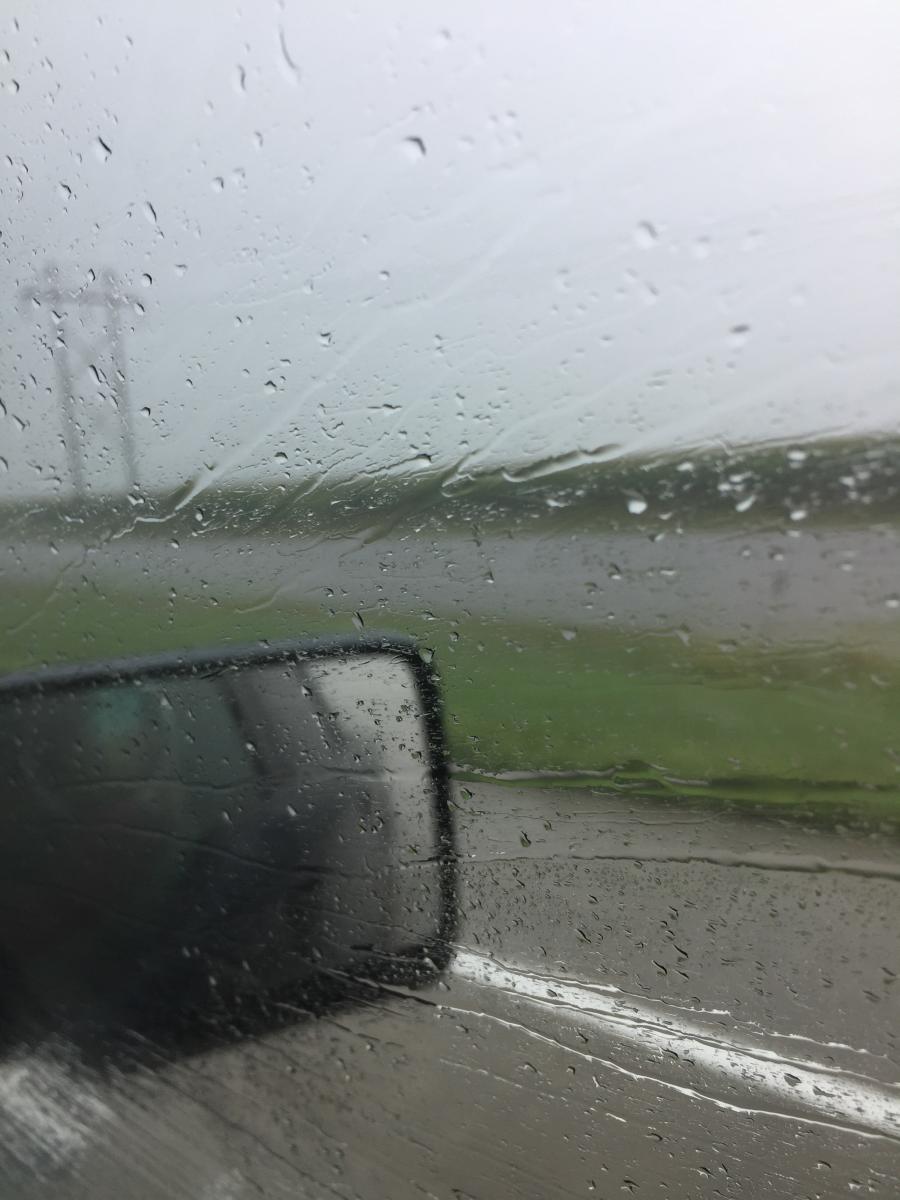
Water ponding in ditches along Interstate 29 southbound near Hankinson, ND. (Photo by Lydia Peterson) |
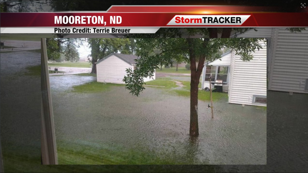
Photo of water ponding after heavy rainfall near Mooreton, ND. Courtesy of WDAY/WDAZ News (Photo by Terrie Breuer) |
Radar:
Images will be added at a future date.
Rain Reports
Location                     Amount    Time/Date       Provider

Havana ND                    6.33 in   0700 AM 08/15   UCOOP
Lidgerwood ND                2.88 in   0700 AM 08/15   COOP
Mcleod ND 3 N                2.14 in   0849 AM 08/15   RAWS
Mcleod ND 3 E                2.14 in   0825 AM 08/15   COOP
Barrie ND 2 WSW (Ekre NDAWN) 1.78 in   0705 AM 08/15   OTHER
Edwards MN 5 S               1.72 in   0700 AM 08/15   COCORAHS
North River ND               1.63 in   0800 AM 08/15   COCORAHS
Elizabeth MN 6 E             1.59 in   0930 AM 08/15   HADS
Breckenridge MN (Ottertail R 1.52 in   0900 AM 08/15   HADS
Lisbon ND                    1.39 in   0800 AM 08/15   COCORAHS
Menahga MN 1 W               1.29 in   0700 AM 08/15   COCORAHS
Dunvilla MN 4 W              1.29 in   0700 AM 08/15   COCORAHS
Richville MN 1 NW            1.27 in   0700 AM 08/15   COCORAHS
Fergus Falls MN 3 W (Pelican 1.25 in   0845 AM 08/15   HADS
Lisbon ND 2 W (NDAWN)        1.14 in   0705 AM 08/15   OTHER
Campbell MN (Rabitt R)       1.13 in   0930 AM 08/15   HADS
Fargo ND (APT)               1.12 in   0653 AM 08/15   ASOS
Clitherall MN 1 WSW          1.10 in   0700 AM 08/15   COCORAHS
Campbell MN 4 W (Rabbitt R)  1.08 in   0900 AM 08/15   HADS
Battle Lake MN 2 S           1.05 in   0700 AM 08/15   COCORAHS
Deer Creek MN 1 W            1.04 in   0700 AM 08/15   COCORAHS
Fingal ND (NDAWN)            1.01 in   0705 AM 08/15   OTHER
Westbury MN 3 ESE            1.00 in   0700 AM 08/15   COCORAHS
Leonard ND (NDAWN)           0.95 in   0705 AM 08/15   OTHER
North River ND 2 ESE         0.94 in   0800 AM 08/15   COCORAHS
Fargo ND (NDSU NDAWN)        0.92 in   0705 AM 08/15   OTHER
New York Mills MN            0.90 in   0730 AM 08/15   COOP
Oxbow ND  1 SSE              0.87 in   0700 AM 08/15   COCORAHS
Detroit Lakes MN (DNR)       0.86 in   0920 AM 08/15   RAWS
Valley City ND 2 NW          0.74 in   0700 AM 08/15   COCORAHS
Cormorant MN 5 NW            0.72 in   0700 AM 08/15   COCORAHS
Huntersville 3 WNW           0.69 in   0845 AM 08/15   HADS
Dazey ND (NDAWN)             0.68 in   0705 AM 08/15   OTHER
Wadena MN 13 E               0.62 in   0900 AM 08/15   HADS
Glyndon MN 2 Ww (SB Buffalo  0.61 in   0845 AM 08/15   HADS
Glyndon MN 2 N               0.59 in   0845 AM 08/15   HADS
Park Rapids MN (APT)         0.36 in   0653 AM 08/15   ASOS
Felton MN 6 ENE              0.36 in   0745 AM 08/15   HADS
Badoura MN (DNR)             0.31 in   0906 AM 08/15   RAWS
Galesburg ND (NDAWN)         0.23 in   0705 AM 08/15   OTHER
Grand Forks ND (AFB)         0.23 in   0656 AM 08/15   ASOS
Pennington MN 2 S            0.20 in   0900 AM 08/15   HADS
Warroad MN                   0.20 in   0930 AM 08/15   HADS
Itasca MN (DNR)              0.16 in   0907 AM 08/15   RAWS
Perley MN (NDAWN)            0.13 in   0705 AM 08/15   OTHER
Lake Itasca 4 NNW            0.12 in   0900 AM 08/15   HADS
Hendrum MN 2 W               0.12 in   0700 AM 08/15   COCORAHS
Grand Forks ND (NWS)         0.11 in   0700 AM 08/15   COOP
Ada MN                       0.11 in   0705 AM 08/15   COOP
Michigan ND                  0.10 in   0700 AM 08/15   UCOOP
Greenbush MN (NDAWN)         0.10 in   0705 AM 08/15   OTHER
Kempton ND 2 NE              0.09 in   0700 AM 08/15   COCORAHS
Starkweather ND              0.08 in   0700 AM 08/15   UCOOP
Grand Forks ND (APT)         0.08 in   0653 AM 08/15   ASOS
3 E Turtle River             0.07 in   0700 AM 08/15   COCORAHS
Caribou MN                   0.07 in   0830 AM 08/15   HADS
Baudette MN (APT)            0.07 in   0653 AM 08/15   ASOS
Bemidji MN (DNR)             0.07 in   0906 AM 08/15   RAWS
Michigan ND 2 W (NDAWN)      0.07 in   0705 AM 08/15   OTHER
Bemidji MN 2 SW              0.06 in   0900 AM 08/15   HADS
Mahnomen MN 1 SE             0.05 in   0845 AM 08/15   HADS
Inkster ND 3 WNW (NDAWN)     0.05 in   0705 AM 08/15   OTHER
Mayville ND                  0.05 in   0700 AM 08/15   COOP
Valley City ND 8 NW          0.05 in   0900 AM 08/15   HADS
Baudette MN 12 S             0.04 in   0715 AM 08/15   HADS
Eldred MN (NDAWN)            0.04 in   0705 AM 08/15   OTHER
Crookston MN (NW Experiment  0.04 in   0800 AM 08/15   COOP
Devils Lake ND (APT)         0.02 in   0656 AM 08/15   ASOS
Tolna ND Coulee              0.02 in   0900 AM 08/15   HADS
Fergus Falls MN 6 SW         0.02 in   0900 AM 08/15   HADS
Ada MN                       0.01 in   0830 AM 08/15   HADS
Kelliher MN (DNR)            0.01 in   0807 AM 08/15   RAWS
Mayville ND (NDAWN)          0.01 in   0705 AM 08/15   OTHER
Waskish MN 4 NE              0.01 in   0930 AM 08/15   HADS
Grygla MN 6 WNW              0.01 in   0830 AM 08/15   HADS
Roosevelt MN 5 SSW           0.01 in   0915 AM 08/15   HADS
Charlesville MN 3 NNE        0.01 in   0900 AM 08/15   HADS


..TIME...   ...EVENT...      ...CITY LOCATION...     ...LAT.LON...
..DATE...   ....MAG....      ..COUNTY LOCATION..ST.. ...SOURCE....
            ..REMARKS..

0700 AM     HEAVY RAIN       3 N MOORETON            46.31N 96.88W
08/14/2017  E8.00 INCH       RICHLAND           ND   PUBLIC

            EVENT TOTAL RAINFALL NEAR INTERSECTION OF COUNTY ROAD 1
            AND COUNTY ROAD 10

0800 AM     HEAVY RAIN       2 SW HANKINSON          46.05N 96.92W
08/14/2017  E5.00 INCH       RICHLAND           ND   PUBLIC

            EVENT TOTAL RAINFALL FROM LAKE ELSIE AREA

0800 AM     HEAVY RAIN       1 E BRECKENRIDGE        46.26N 96.57W
08/14/2017  E1.01 INCH       WILKIN             MN   PUBLIC

            EVENT TOTAL RAINFALL

0800 AM     HEAVY RAIN       2 E HARWOOD             46.98N 96.84W
08/14/2017  E2.50 INCH       CASS               ND   PUBLIC

            EVENT TOTAL RAINFALL
0700 AM     HEAVY RAIN       WEST FARGO              46.87N 96.90W
08/14/2017  M1.41 INCH       CASS               ND   BROADCAST MEDIA

            EVENT TOTAL RAINFALL
0630 AM     HEAVY RAIN       4 W DUNVILLA            46.66N 96.10W
08/14/2017  M1.29 INCH       OTTER TAIL         MN   COCORAHS

            EVENT TOTAL RAINFALL

0700 AM     HEAVY RAIN       1 W MENAHGA             46.75N 95.12W
08/14/2017  M1.29 INCH       WADENA             MN   COCORAHS

            EVENT TOTAL RAINFALL

0700 AM     HEAVY RAIN       LIDGERWOOD              46.07N 97.15W
08/14/2017  M2.88 INCH       RICHLAND           ND   CO-OP OBSERVER

            EVENT TOTAL RAINFALL

0700 AM     HEAVY RAIN       5 S EDWARDS             46.38N 95.99W
08/14/2017  M1.71 INCH       OTTER TAIL         MN   COCORAHS

            EVENT TOTAL RAINFALL

0700 AM     HEAVY RAIN       1 WNW OTTERTAIL         46.43N 95.58W
08/14/2017  M1.51 INCH       OTTER TAIL         MN   COCORAHS

            EVENT TOTAL RAINFALL

0800 AM     HEAVY RAIN       NORTH RIVER             46.95N 96.80W
08/14/2017  M1.63 INCH       CLAY               ND   COCORAHS

            EVENT TOTAL RAINFALL

0800 AM     HEAVY RAIN       3 E MCLEOD              46.39N 97.24W
08/14/2017  M2.14 INCH       RICHLAND           ND   CO-OP OBSERVER

            EVENT TOTAL RAINFALL

0800 AM     HEAVY RAIN       4 NNE ELBOW LAKE        46.05N 95.95W
08/14/2017  M2.83 INCH       GRANT              MN   COCORAHS

            EVENT TOTAL RAINFALL
0815 AM     HEAVY RAIN       FORMAN                  46.11N 97.64W
08/13/2017  M3.20 INCH       SARGENT            ND   CO-OP OBSERVER

            24 HOUR RAINFALL REPORTED BY ARB OBSERVER

0900 AM     HEAVY RAIN       COGSWELL                46.11N 97.78W
08/13/2017  M4.28 INCH       SARGENT            ND   CO-OP OBSERVER

            24 HOUR RAINFALL REPORTED BY ARB OBSERVER

1100 AM     HEAVY RAIN       6 NE FORMAN             46.17N 97.55W
08/13/2017  M2.42 INCH       SARGENT            ND   CO-OP OBSERVER

            24 HOUR RAINFALL REPORTED BY ARB OBSERVER.

0400 PM     HEAVY RAIN       ASHBY                   46.09N 95.82W
08/13/2017  E1.50 INCH       GRANT              MN   PUBLIC

            24 HOUR RAINFALL

0800 PM     HEAVY RAIN       4 N OTTERTAIL           46.49N 95.56W
08/13/2017  E1.66 INCH       OTTER TAIL         MN   PUBLIC

            24 HOUR RAINFALL

0900 PM     HEAVY RAIN       4 S MOORETON            46.21N 96.88W
08/13/2017  E1.81 INCH       RICHLAND           ND   PUBLIC

            EVENT TOTAL RAINFALL

0630 AM     HEAVY RAIN       HARWOOD                 46.98N 96.88W
08/14/2017  E1.60 INCH       CASS               ND   PUBLIC

            EVENT TOTAL RAINFALL

0815 AM     HEAVY RAIN       2 SE OTTERTAIL          46.41N 95.53W
08/14/2017  M1.68 INCH       OTTER TAIL         MN   CO-OP OBSERVER

            EVENT TOTAL RAINFALL

0900 AM     HEAVY RAIN       HAVANA                  45.95N 97.62W
08/14/2017  M6.33 INCH       SARGENT            ND   CO-OP OBSERVER

            EVENT TOTAL RAINFALL

0900 AM     HEAVY RAIN       SEBEKA                  46.63N 95.09W
08/14/2017  M1.11 INCH       WADENA             MN   CO-OP OBSERVER

            EVENT TOTAL RAINFALL
0800 AM     HEAVY RAIN       FORMAN                  46.11N 97.64W
08/13/2017  M3.51 INCH       SARGENT            ND   CO-OP OBSERVER

            24 HR RAINFALL. STILL RAINING.

Observations are collected from a variety of sources with varying
equipment and exposures. We thank all volunteer weather observers
for their dedication. Not all data listed are considered official.
 |
Media use of NWS Web News Stories is encouraged! Please acknowledge the NWS as the source of any news information accessed from this site. |
 |