Overview
An upper-level low pressure system was moving into Saskatchewan Friday with a trough of low pressure south into western North Dakota Friday afternoon. A very warm, moist, unstable airmass was in place ahead of this system with dew points in the mid 60s to lower 70s and maximum surface temperatures in the mid 80s to lower 90s. This created an unstable atmosphere and despite weak surface based forcing, isolated strong to severe thunderstorms formed during the day and became quite numerous in the mid to late afternoon.
Of the several clusters of storms which formed, one of the strongest developed to the east of Grand Forks near Fosston MN, moving east-southeast through Bagley and Bemidji, to well past Cass Lake MN. Winds from these storms ranged in the 60-95 mph range and caused considerable tree damage along with some minor structural damage. Other scattered storms formed near the Upper and Lower Red Lakes in Beltrami County Minnesota and one of these produced a brief tornado west of Kelliher MN, which damaged a buildings on a number of farmsteads. Another weak tornado was observed for a brief period in Clay County, just south of Glyndon MN.
In North Dakota, severe thunderstorms affected areas between Carrington and Cooperstown early in the afternoon, where large hail and high winds caused extensive crop damage. Late that evening and overnight, a band of storms first produced hail in areas south and west of Leeds ND and a brief funnel cloud northwest of Minnewauken. Eventually, isolated episodes of large hail and/or strong winds spread from Enderlin ND across the southern Red River Valley into the Pelican Rapids MN area.
Tornadoes:
|
Tornado #1 - 10 W Kelliher, MN
Track Map 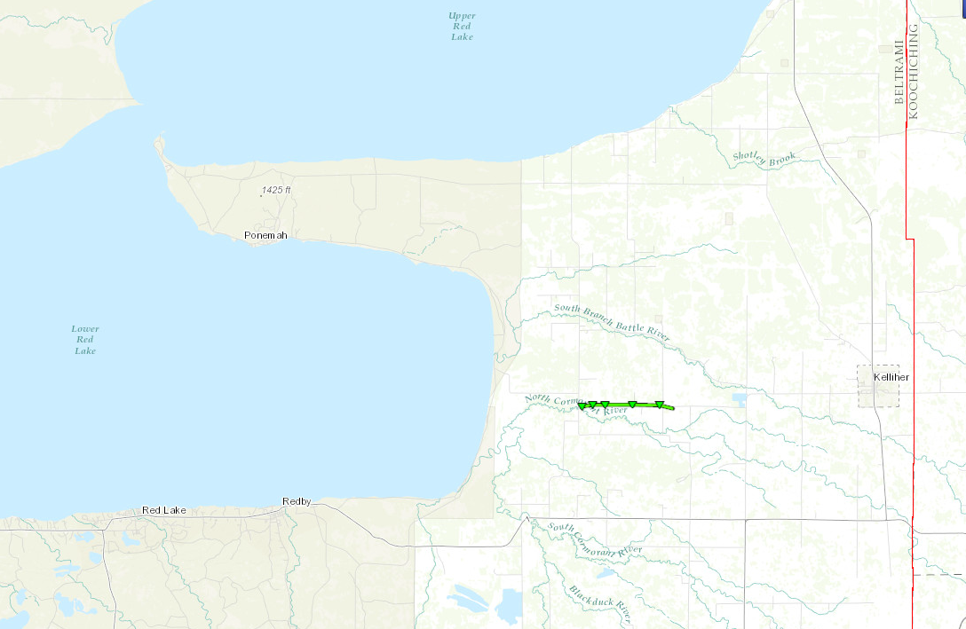 
|
||||||||||||||||
|
Tornado #2 - 3.6 S Glyndon, MN
Track Map 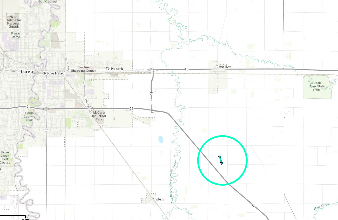
|
||||||||||||||||
The Enhanced Fujita (EF) Scale classifies tornadoes into the following categories:
| EF0 Weak 65-85 mph |
EF1 Moderate 86-110 mph |
EF2 Significant 111-135 mph |
EF3 Severe 136-165 mph |
EF4 Extreme 166-200 mph |
EF5 Catastrophic 200+ mph |
 |
|||||
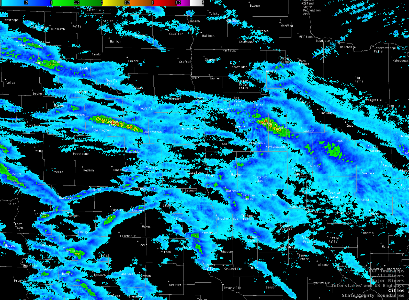
Radar:
| 4pm-10pm | 7pm-1am |
Storm Reports
..TIME...   ...EVENT...      ...CITY LOCATION...     ...LAT.LON...
..DATE...   ....MAG....      ..COUNTY LOCATION..ST.. ...SOURCE....
            ..REMARKS..

1005 AM     HAIL             1 N HANNAH              48.99N 98.69W
07/21/2017  E1.00 INCH       CAVALIER           ND   OTHER FEDERAL

            REPORTED BY BORDER PATROL.

0210 PM     HAIL             4 N GRYGLA              48.36N 95.62W
07/21/2017  E1.00 INCH       MARSHALL           MN   PUBLIC

            HAIL VARIED RANGING FROM THE SIZE OF PEAS TO QUARTERS.
            AREA BEAN FIELDS DAMAGED.

0254 PM     TSTM WND GST     2 S HUNTER              47.16N 97.22W
07/21/2017  M46.00 MPH       CASS               ND   MESONET

            PEAK WINDS MEASURED AT A PERSONAL WEATHER STATION.

0340 PM     HAIL             2 SE SAUM               47.95N 94.65W
07/21/2017  E1.00 INCH       BELTRAMI           MN   PUBLIC

            MOSTLY PEA TO MARBLE SIZED HAIL.

0342 PM     TSTM WND DMG     5 W COOPERSTOWN         47.44N 98.23W
07/21/2017                   GRIGGS             ND   PUBLIC

            CORN FIELD SHREDDED WEST OF COOPERTOWN

0345 PM     TORNADO          10 W KELLIHER           47.94N 94.66W
07/21/2017  F1               BELTRAMI           MN   NWS STORM SURVEY

            THIS TORNADO TRACKED EASTWARD WITH NUMEROUS INTERMITTENT
            TOUCHDOWNS ALONG A ROUGHLY 3 MILE TRACK ALONG CR34 TO
            AROUND 7W OF KELLIHER BY 350 PM CDT. NUMEROUS TREES WERE
            SNAPPED AND A COUPLE OF GRAIN BINS WERE TOPPLED. ROOF
            PANELS AND WALLS WERE BLOWN OUT OF POLE SHEDS AND CALVING
            SHEDS WERE FLIPPED. INSULATION AND ROOFING METAL WAS
            STREWN ABOUT. PEAK WINDS ESTIMATED TO 95 MPH. MAXIMUM
            WIDTH TO 200 YARDS.

0351 PM     TSTM WND GST     3 W COOPERSTOWN         47.44N 98.19W
07/21/2017  M58.00 MPH       GRIGGS             ND   MESONET

            PEAK WIND MEASURED AT AN NDAWN STATION.

0406 PM     TSTM WND GST     SHOOKS                  47.87N 94.44W
07/21/2017  M60.00 MPH       BELTRAMI           MN   MESONET

            PEAK WINDS MEASURED AT AN RWIS STATION.

0413 PM     HAIL             MCINTOSH                47.64N 95.89W
07/21/2017  E0.50 INCH       POLK               MN   TRAINED SPOTTER

0415 PM     TSTM WND GST     5 WNW HOPE              47.35N 97.82W
07/21/2017  M59.00 MPH       STEELE             ND   MESONET

            PERSONAL WEATHER STATION

0416 PM     TSTM WND GST     1 N PILLSBURY           47.22N 97.80W
07/21/2017  M49.00 MPH       BARNES             ND   MESONET

            PEAK WINDS MEARURE AT AN NDAWN STATION.

0420 PM     TSTM WND DMG     ERSKINE                 47.66N 96.01W
07/21/2017                   POLK               MN   BROADCAST MEDIA

            NUMEROUS LARGE BRANCHES BROKEN DOWN AROUND TOWN.

0422 PM     TSTM WND GST     5 NE HOPE               47.38N 97.64W
07/21/2017  M53.00 MPH       STEELE             ND   MESONET

            PEAK WINDS MEASURED AT AN NDAWN STATION.

0425 PM     TSTM WND DMG     1 E ERSKINE             47.66N 95.99W
07/21/2017                   POLK               MN   PUBLIC

            AT LEAST 6 TO 8 LARGE TREES DOWN IN YARD, JUST EAST OF
            ERSKINE. ONE TREE WAS UPROOTED.

0435 PM     TSTM WND GST     1 NE FOSSTON            47.59N 95.73W
07/21/2017  M49.00 MPH       POLK               MN   ASOS

            PEAK WIND MEASURED AT THE FOSSTON AIRPORT ASOS.

0445 PM     TSTM WND DMG     2 NE LENGBY             47.54N 95.60W
07/21/2017                   POLK               MN   PUBLIC

            BRANCHES DOWN AND POWER OUT. ONLY HAD PEA SIZED HAIL.

0446 PM     TSTM WND GST     6 S LENGBY              47.43N 95.63W
07/21/2017  E60.00 MPH       MAHNOMEN           MN   TRAINED SPOTTER

0450 PM     TSTM WND DMG     1 N EBRO                47.51N 95.53W
07/21/2017                   CLEARWATER         MN   NWS STORM SURVEY

            NUMEROUS LARGE PINE, OAK, AND POPLAR TREE BRANCHES AND
            LIMBS BROKEN DOWN ACROSS SOUTHERN POPPLE AND NORTHERN
            FALK TOWNSHIPS.

0500 PM     TSTM WND DMG     BAGLEY                  47.52N 95.40W
07/21/2017                   CLEARWATER         MN   PUBLIC

            NUMEROUS LARGE PINE, OAK, AND POPLAR TREES AND BRANCHES
            DOWN IN THE BAGLEY AREA, ALONG WITH POWER LINES DOWN
            ACROSS SOUTHERN COPLEY TOWNSHIP.

0500 PM     HAIL             CASSELTON               46.90N 97.21W
07/21/2017  E0.88 INCH       CASS               ND   PUBLIC

            DIME TO NICKEL SIZED HAIL.

0500 PM     HAIL             BAGLEY                  47.52N 95.40W
07/21/2017  E0.88 INCH       CLEARWATER         MN   PUBLIC

            HAIL VARYING FROM PEA TO NICKEL SIZE

0500 PM     TSTM WND DMG     1 S BAGLEY              47.51N 95.40W
07/21/2017                   CLEARWATER         MN   PUBLIC

            NUMEROUS TREES BLOWN DOWN.

0500 PM     HAIL             EBRO                    47.50N 95.53W
07/21/2017  E1.25 INCH       CLEARWATER         MN   PUBLIC

            MOSTLY DIME TO NICKEL SIZE HAIL, BUT SOME LARGER
            HAILSTONES WERE ABOUT A HALF DOLLAR IN SIZE

0501 PM     TSTM WND GST     4 SSE BAGLEY            47.47N 95.37W
07/21/2017  E90.00 MPH       CLEARWATER         MN   TRAINED SPOTTER

            WINDS BLEW OUT A WINDOW ON A HOUSE AND BROKE DOWN
            NUMEROUS LARGE BRANCHES. NUMEROUS PINE, OAK, AND POPLAR
            TREES SNAPPED OR UPROOTED ACROSS NORA TOWNSHIP. DOWNED
            PINE TREES WERE LEFT LYING ACROSS HWY 92 FOR ABOUT SIX
            MILES OF ITS NORTH-SOUTH LENGTH.

0504 PM     HAIL             4 SSE BAGLEY            47.47N 95.37W
07/21/2017  E2.00 INCH       CLEARWATER         MN   TRAINED SPOTTER

            IN ADDITION TO SEVERE WINDS... LARGE HAIL COVERED THE
            GROUND.

0516 PM     TSTM WND DMG     6 S SOLWAY              47.43N 95.13W
07/21/2017                   BELTRAMI           MN   PUBLIC

            PEA SIZE HAIL, BRANCHES SCATTERED, AND A FEW TREES
            SNAPPED

0522 PM     TSTM WND GST     3 E BECIDA              47.35N 95.02W
07/21/2017  E75.00 MPH       HUBBARD            MN   TRAINED SPOTTER

            METAL ROOFING PANELS TORN OFF OF A BARN. LOCATION AND
            TIME ESTIMATED PENDING FURTHER REPORTING.

0527 PM     TSTM WND DMG     1 N WILTON              47.52N 94.99W
07/21/2017                   BELTRAMI           MN   NWS STORM SURVEY

            NUMEROUS LARGE TREE BRANCHES AND LIMBS BROKEN DOWN ACROSS
            SOUTHERN ECKLES TOWNSHIP.

0534 PM     TORNADO          4 S GLYNDON             46.81N 96.58W
07/21/2017  F0               CLAY               MN   STORM CHASER

            A WEAK TORNADO WAS OBSERVED FOR ABOUT A MINUTE OVER
            LARGELY OPEN FARMLAND JUST NORTH OF I-94 IN EXTREME
            SOUTHEAST GLYNDON TOWNSHIP. PEAK WINDS ESTIMATED TO 75
            MPH. MAXIMUM WIDTH TO 100 YARDS. TRACK WAS ESTIMATED TO
            BE SOUTHEASTERLY FOR A HALF MILE OR LESS.

0536 PM     TSTM WND GST     3 NW BEMIDJI            47.51N 94.92W
07/21/2017  M54.00 MPH       BELTRAMI           MN   AWOS

            PEAK WINDS MEASURED AT THE BEMIDJI AIRPORT AWOS.

0537 PM     TSTM WND GST     3 WNW BEMIDJI           47.50N 94.94W
07/21/2017  M62.00 MPH       BELTRAMI           MN   MESONET

            PEAK WINDS MEASURED AT THE BEMIDJI RAWS SITATION.

0540 PM     TSTM WND DMG     7 N BEMIDJI             47.58N 94.88W
07/21/2017                   BELTRAMI           MN   PUBLIC

            SEVERAL TREES DOWN. SOME DOCKS, BOATS, AND BOAT LIFTS,
            FLIPPED ON LAKE MOVIL.

0540 PM     TSTM WND DMG     TURTLE RIVER            47.59N 94.76W
07/21/2017                   BELTRAMI           MN   PUBLIC

            SEVERAL TREES DOWN AND NUMEROUS BRANCHES DOWN

0540 PM     TSTM WND DMG     5 N BEMIDJI             47.55N 94.88W
07/21/2017                   BELTRAMI           MN   EMERGENCY MNGR

            NUMEROUS LARGE TREE BRANCHES AND LIMBS BROKEN DOWN. POWER
            OUTAGES.

0542 PM     TSTM WND DMG     2 NNE LAPORTE           47.24N 94.74W
07/21/2017                   HUBBARD            MN   PUBLIC

            A FEW LARGE TREES BROKEN DOWN AROUND GARFIELD LAKE.

0545 PM     TSTM WND DMG     7 NE BEMIDJI            47.55N 94.77W
07/21/2017                   BELTRAMI           MN   PUBLIC

            SEVERAL LARGE TREES WERE SNAPPED OR UPROOTED.

0545 PM     HAIL             3 ENE CALLAWAY          47.00N 95.85W
07/21/2017  E1.00 INCH       BECKER             MN   PUBLIC

            VERY HEAVY RAIN AND A FEW LARGE HAIL.

0550 PM     HAIL             1 S BENEDICT            47.14N 94.69W
07/21/2017  E1.00 INCH       HUBBARD            MN   TRAINED SPOTTER

            A FEW QUARTER SIZED HAIL AND VERY STRONG WINDS. SOME
            LARGE 4-6 INCH DIAMETER BRANCHES BROKEN DOWN AROUND
            BENEDICT LAKE.

0553 PM     HAIL             1 E DOWNER              46.75N 96.47W
07/21/2017  E1.00 INCH       CLAY               MN   STORM CHASER

            HAIL COVERED THE ROAD EAST OF DOWNER. TIME ESTIMATED
            BASED ON RADAR.

0600 PM     TSTM WND DMG     8 ESE BEMIDJI           47.44N 94.72W
07/21/2017                   BELTRAMI           MN   PUBLIC

            LARGE OAK TREE TOPPLED ON TO HOUSE NEAR LAKE ANDRUSIA.
            REPORT POSTED VIA SOCIAL MEDIA. TIME ESTIMATED BASED ON
            RADAR.

0610 PM     HAIL             11 SW HANKINSON         45.96N 97.06W
07/21/2017  E1.00 INCH       RICHLAND           ND   PUBLIC

            MOSTLY PEA TO DIME SIZE.

0710 PM     HAIL             3 SE ROTHSAY            46.44N 96.24W
07/21/2017  E1.25 INCH       OTTER TAIL         MN   PUBLIC

            SOME QUARTER TO HALF DOLLAR SIZED HAIL IN HEAVY RAIN.

0716 PM     TSTM WND GST     2 S HUNTER              47.16N 97.22W
07/21/2017  M56.00 MPH       CASS               ND   MESONET

            PEAK WINDS MEASURED AT A PERSONAL WEATHER STATION.

1100 PM     HAIL             6 S PLEASANT LAKE       48.27N 99.80W
07/21/2017  E1.00 INCH       BENSON             ND   PUBLIC

1106 PM     TSTM WND GST     1 N BAKER               48.18N 99.65W
07/21/2017  M48.00 MPH       BENSON             ND   MESONET

            PEAK WINDS MEASURED AT AN NDAWN STATION.

1118 PM     HAIL             1 N HARLOW              48.18N 99.52W
07/21/2017  E1.25 INCH       BENSON             ND   PUBLIC

            HAIL RANGED FROM THE SIZE OF PEAS TO HALF DOLLAR

1125 PM     FUNNEL CLOUD     5 NW MINNEWAUKAN        48.12N 99.33W
07/21/2017                   BENSON             ND   LAW ENFORCEMENT

            VIEWED FROM ABOUT 5N MINNEWAUKEN LOOKING WEST.

1133 PM     HAIL             3 SSE BRINSMADE         48.14N 99.30W
07/21/2017  E1.50 INCH       BENSON             ND   PUBLIC

            LARGE HAIL AND VERY STRONG WINDS. ESTIMATED TO 50 MPH OR
            GREATER.

1246 AM     HAIL             3 S HAMAR               47.80N 98.57W
07/22/2017  E1.25 INCH       EDDY               ND   PUBLIC

            LARGE DIME TO HALF DOLLAR SIZED HAIL FOR A COUPLE OF
            MINUTES.

0242 AM     TSTM WND GST     2 S HUNTER              47.16N 97.22W
07/22/2017  M60.00 MPH       CASS               ND   PUBLIC

            PERSONAL WEATHER STATION

0325 AM     HAIL             6 S ENDERLIN            46.54N 97.60W
07/22/2017  E1.25 INCH       RANSOM             ND   PUBLIC

            LARGE HAIL AND STRONG WINDS. SOME SMALL BRANCHES DOWN
            AROUND THE FARMYARD. TIME ESTIMATED BASED ON RADAR.

0332 AM     HAIL             2 N COMSTOCK            46.69N 96.75W
07/22/2017  E1.25 INCH       CLAY               MN   PUBLIC

            HAIL PATCH NOTED ACROSS HIGHWAY 75. SOME WAS STILL A BIT
            BIGGER THAN A QUARTER MAYBE 10 MINUTES AFTER IT PASSED.
            TIME ESTIMATED BASED ON RADAR.

0400 AM     HAIL             3 N LAWNDALE            46.60N 96.36W
07/22/2017  E1.00 INCH       WILKIN             MN   PUBLIC

            HEAVY RAIN AND WIND. SOME LARGE HAIL.

0412 AM     TSTM WND GST     1 SE DUNVILLA           46.65N 96.00W
07/22/2017  M53.00 MPH       OTTER TAIL         MN   PUBLIC

            PERSONAL WEATHER STATION. TIME ESTIMATED FROM RADAR.

0420 AM     TSTM WND DMG     4 E PELICAN RAPIDS      46.57N 96.00W
07/22/2017                   OTTER TAIL         MN   PUBLIC

            LIDA GREENS GOLF COURSE SUSTAINED NUMEROUS DAMAGED TREES
            WITH BRANCHES AS LARGE AS 8 INCHES IN DIAMETER BROKEN
            OFF. TIME ESTIMATED FROM RADAR.

0426 AM     HAIL             MAPLEWOOD STATE PARK    46.53N 95.95W
07/22/2017  E1.50 INCH       OTTER TAIL         MN   PARK/FOREST SRVC

            HAIL TO PING BALL SIZE OR LARGER FELL ACROSS NORTHERN
            MAPLEWOOD TOWNSHIP. A FEW LARGE TREES BLOWN DOWN AT THE
            STATE PARK. TIME ESTIMATED BASED ON RADAR.
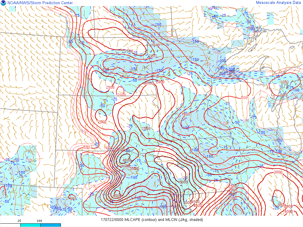
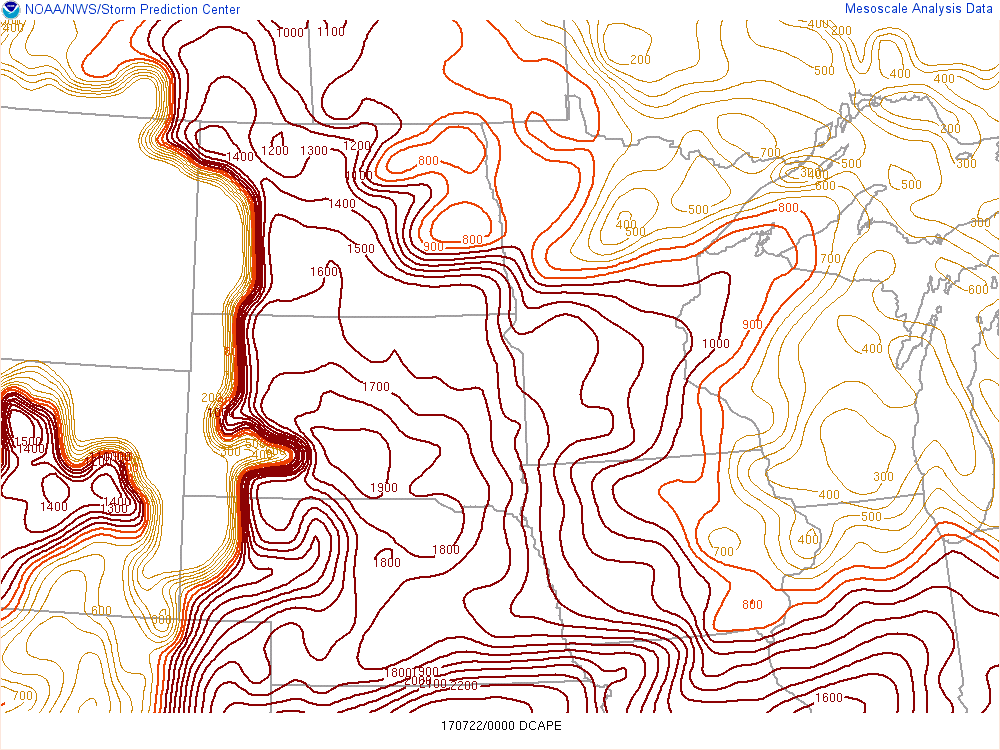
Environment
All Images From 00z July 22 2017
 |
 |
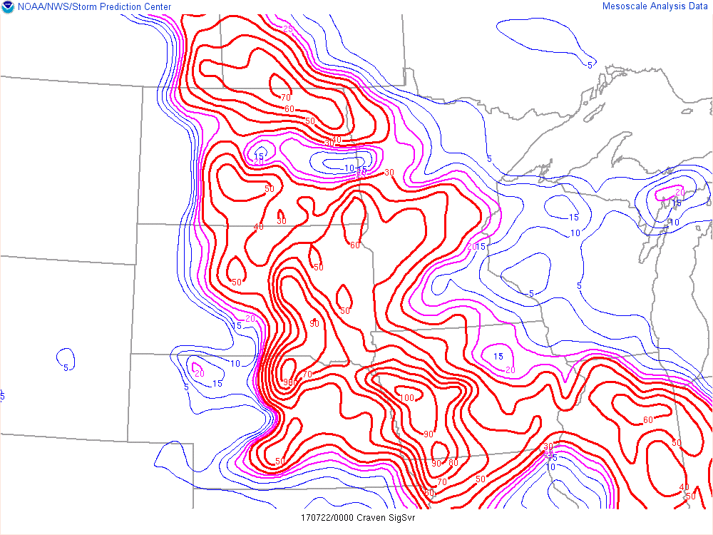 |
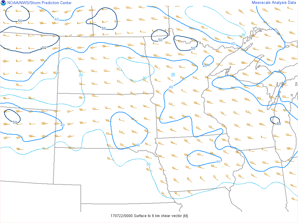
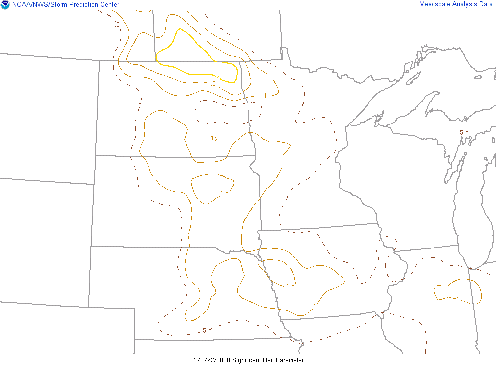
| Figure 1: MLCAPE | Figure 2: DCAPE | Figure 3: Craven/Brooks Sig Severe |
 |
 |
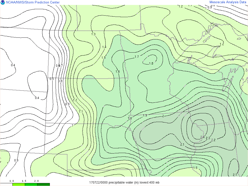 |
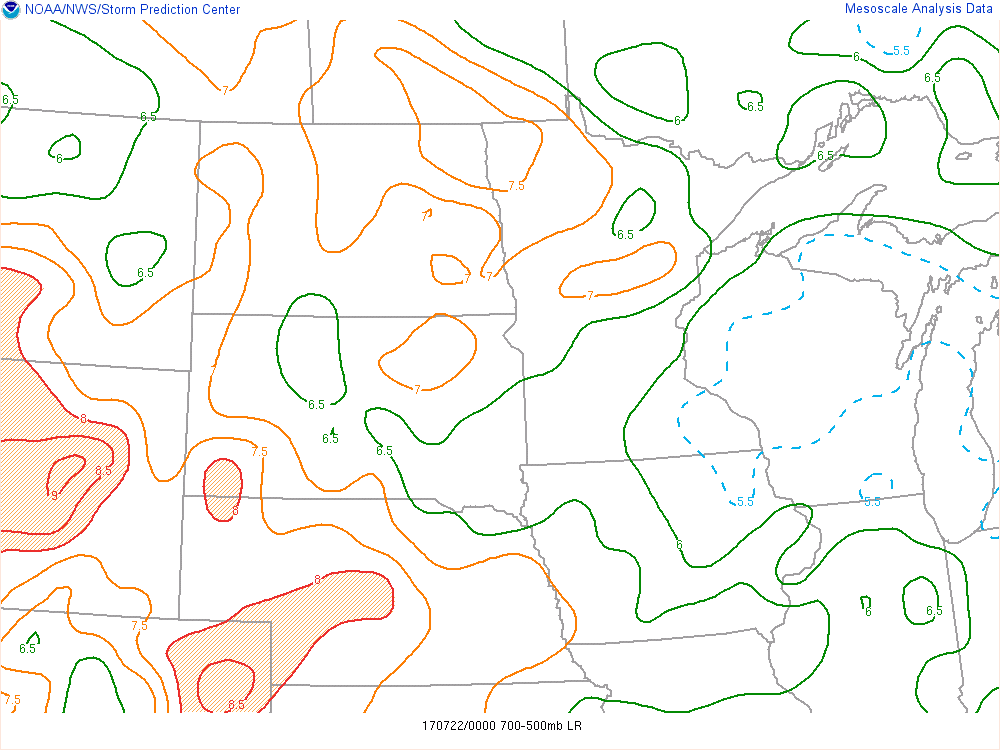
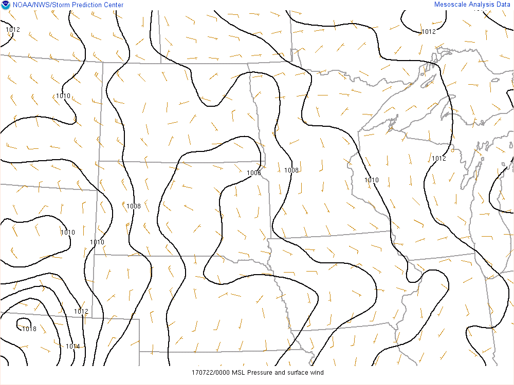
| Figure 4: Mid-Level Lapse Rate | Figure 5: Surface Chart | Figure 6: Precipitable Water |
 |
 |
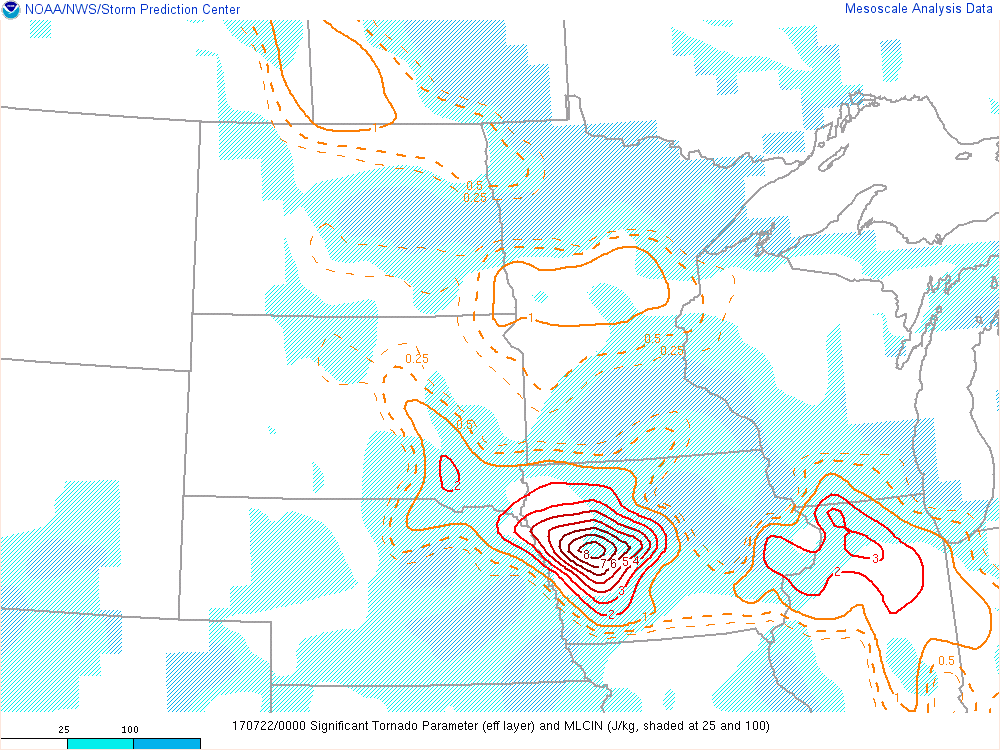 |
| Figure 7: 0-6km Shear | Figure 8: Significant Hail Parameter | Figure 9: Significant Tornado Parameter |
Additional Information
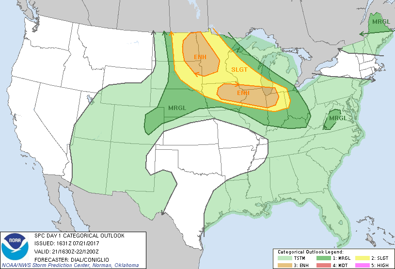
The Forecast
 |
 |
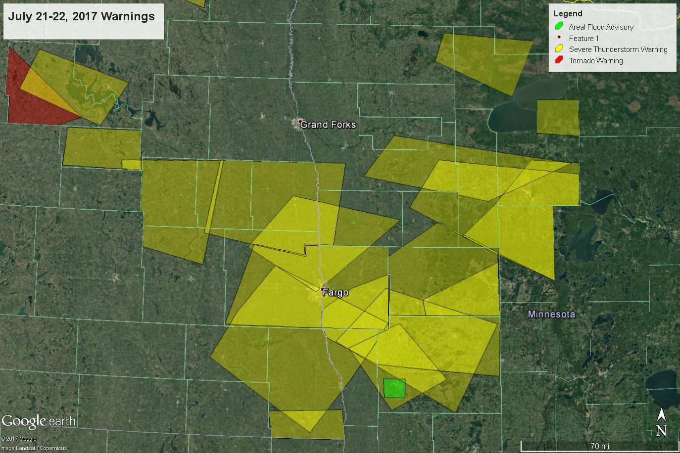 |
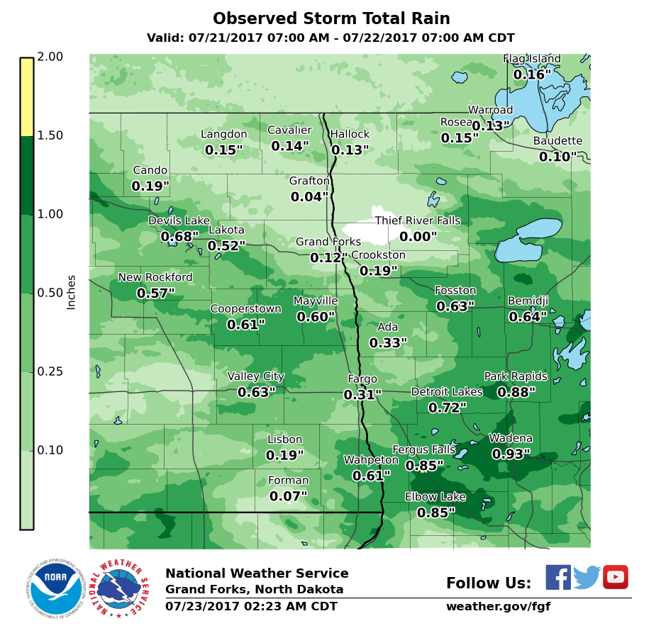
| SPC Day 1 Categorical Outlook | Estimated Rainfall | Warnings |
 |
 |
Link to a GOES-16 Satellite loop of 1 minute Clean IR Imagery during the event: |
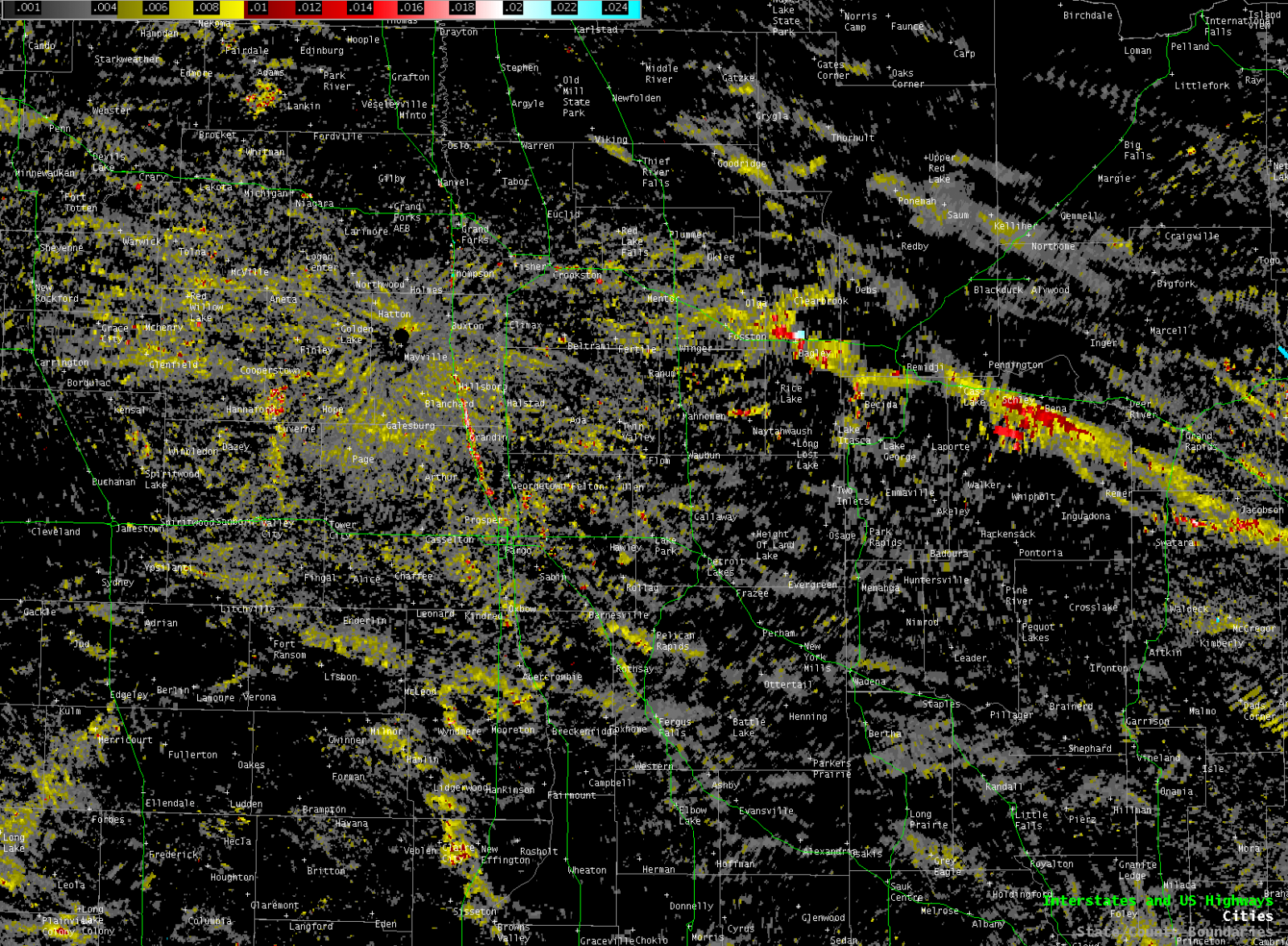
| MRMS MESH (Hail) Tracks | MRMS Low Level Rotation Tracks |
 |
Media use of NWS Web News Stories is encouraged! Please acknowledge the NWS as the source of any news information accessed from this site. |
|

