Overview
Storms developed earlier in the day further to the west due to divergence aloft. An instability gradient further south, along with limited heating to the north, allowed for the best environment to be in southeastern North Dakota and west central Minnesota. The storms progressed to the east with some southerly component due to these gradients and wind shear vectors. The main impacts were damaging winds, hail, and isolated heavy rainfall. The worst of the damage was in Fargo-Moorhead, Lisbon, and Jamestown. Hail to an inch or larger was also seen.
Photos & Video
 |
 |
 |
 |
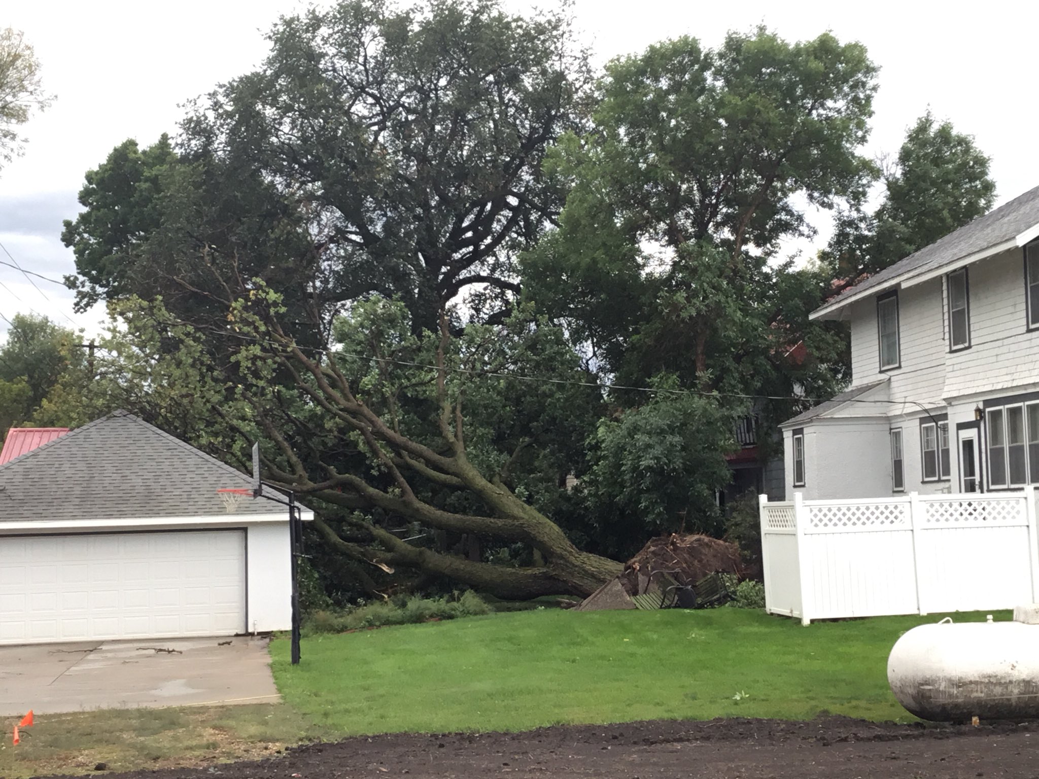
| Lisbon, ND (Courtesy of Eric Whitehill) |
Lisbon, ND (Courtesy of Eric Whitehill) |
Lisbon, ND (Courtesy of Eric Whitehill) |
Lisbon, ND (Courtesy of Eric Whitehill) |
 |
| Fargo, ND (Courtesy of Kim Rueb) |
Radar
Radar loop from 4:00 p.m. to 10:00 p.m. Note the bowing structure that can be seen in southern areas. Also note the parallel stratiform rain farther to the north.
 |
 |
|
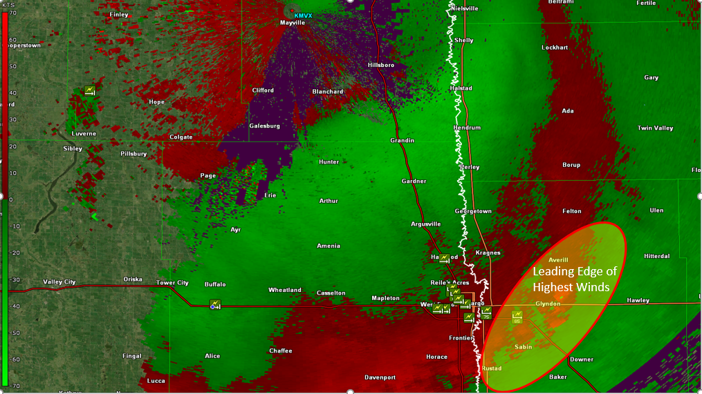
Base Velocity Radar at 6:21 p.m. With Highest Winds Circled |
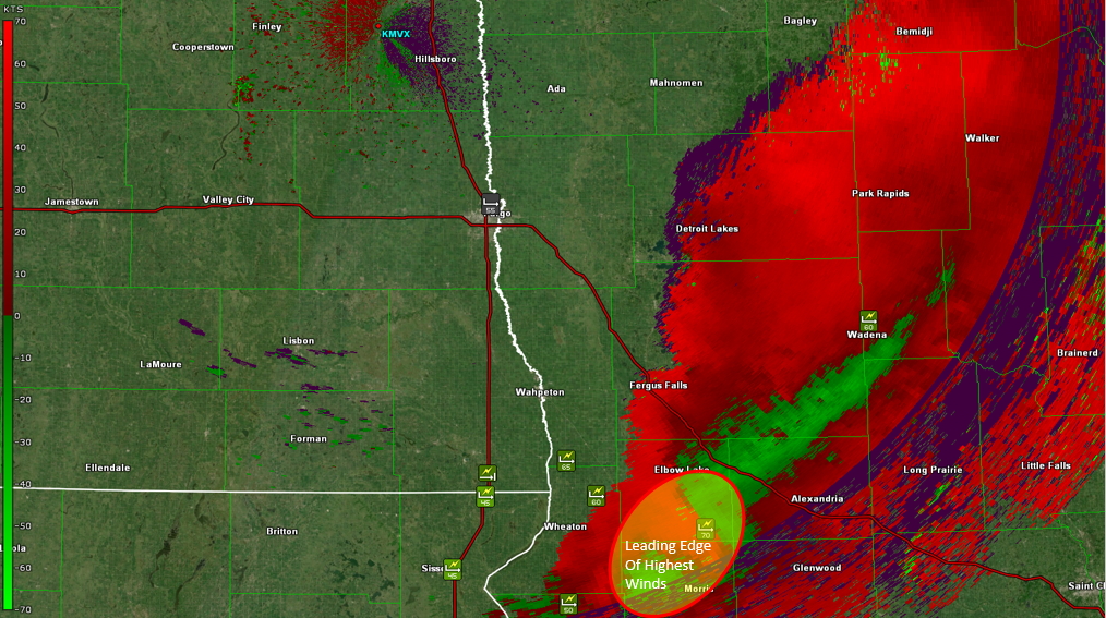
Base Velocity Radar at 7:55 p.m. With Highest Winds Circled |
Wind and Hail Reports
 |
|
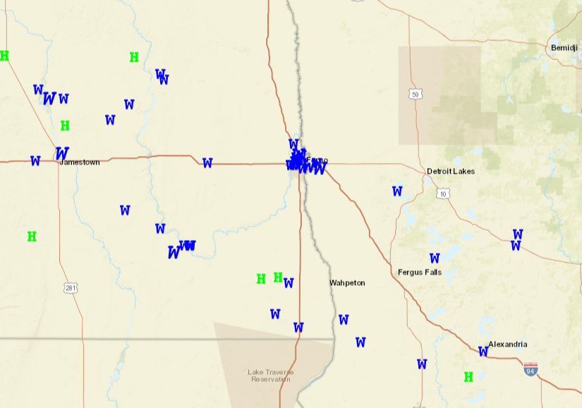
SPC Storm Reports for September 2, 2019 |
PRELIMINARY LOCAL STORM REPORT...SUMMARY
NATIONAL WEATHER SERVICE GRAND FORKS ND
232 PM CDT TUE SEP 3 2019

..TIME...   ...EVENT...      ...CITY LOCATION...     ...LAT.LON...
..DATE...   ....MAG....      ..COUNTY LOCATION..ST.. ...SOURCE....
            ..REMARKS..

0458 PM     TSTM WND DMG     LEAL                    47.11N 98.31W
09/02/2019                   BARNES             ND   BROADCAST MEDIA

            A FEW LARGE TREE BRANCHES BROKEN DOWN IN TOWN. REPORT
            POSTED VIA SOCIAL MEDIA.

0501 PM     TSTM WND GST     2 E DAZEY               47.19N 98.16W
09/02/2019  M58.00 MPH       BARNES             ND   MESONET

            NDAWN MESONET STATION MEASURED 58 MPH WIND GUST AT 501
            PM.

0505 PM     HAIL             COOPERSTOWN             47.44N 98.12W
09/02/2019  E1.00 INCH       GRIGGS             ND   TRAINED SPOTTER

0506 PM     TSTM WND GST     2 E ROGERS              47.07N 98.16W
09/02/2019  M55.00 MPH       BARNES             ND   MESONET

            PERSONAL WEATHER STATION REPORTED 55 MPH WIND GUST. TIME
            ESTIMATED ON RADAR.

0510 PM     TSTM WND GST     4 S LUVERNE             47.19N 97.93W
09/02/2019  M57.00 MPH       BARNES             ND   MESONET

            PERSONAL WEATHER STATION REPORTED 57 MPH WIND GUST. TIME
            ESTIMATED BASED ON RADAR.

0510 PM     TSTM WND GST     5 NNE LUVERNE           47.32N 97.89W
09/02/2019  M63.00 MPH       STEELE             ND   TRAINED SPOTTER

            MEASURED BY PERSONAL WEATHER STATION.

0516 PM     TSTM WND GST     1 N PILLSBURY           47.22N 97.80W
09/02/2019  M56.00 MPH       BARNES             ND   MESONET

            NDAWN STATION REPORTED 56 MPH WIND GUST AT 516 PM

0520 PM     TSTM WND DMG     2 S LITCHVILLE          46.63N 98.19W
09/02/2019                   LAMOURE            ND   PUBLIC

            DEBRIS FROM TREES AND NEARBY CROP FIELD BEING BLOWN
            AROUND

0539 PM     TSTM WND GST     1 NE FORT RANSOM        46.53N 97.92W
09/02/2019  M58.20 MPH       RANSOM             ND   MESONET

            PEAK WIND MEASURED AT A PERSONNAL WEATHER STATION.

0543 PM     TSTM WND DMG     3 S BUFFALO             46.88N 97.55W
09/02/2019                   CASS               ND   BROADCAST MEDIA

            *** 1 INJ *** SEMI TIPPED OVER BY WIND ON I94 NEAR THE
            BUFFALO EXIT. BLOCKED PART OF THE WESTBOUND LANE FOR
            AROUND 30 MINUTES WITH TIME ESTIMATED BASED ON RADAR.

0550 PM     TSTM WND GST     ELLIOTT                 46.40N 97.81W
09/02/2019  E90.00 MPH       RANSOM             ND   TRAINED SPOTTER

            ROOF PANELS WERE BLOWN OFF THE GABLE END OF A CENEX
            STORAGE BUILDING. TIME ESTIMATED BASED ON RADAR.

0553 PM     TSTM WND GST     2 W LISBON              46.44N 97.73W
09/02/2019  M59.00 MPH       RANSOM             ND   MESONET

            WIND GUST MEASURED BY NDAWN STATION

0600 PM     TSTM WND DMG     LISBON                  46.44N 97.68W
09/02/2019                   RANSOM             ND   TRAINED SPOTTER

            REPORTS AND PHOTOS OF NUMEROUS TREES EITHER SNAPPED OR
            UPROOTED TREES. SOME SNAPPED TREES RANGED UP TO 2 FEET IN
            DIAMETER

0604 PM     TSTM WND GST     2 ENE WEST FARGO        46.88N 96.86W
09/02/2019  E90.00 MPH       CASS               ND   BROADCAST MEDIA

            STEEL ROOF PANELS TORN OFF A SHOP BUILDING. PEAK WINDS OF
            80 TO 90 MPH ESTIMATED. TIME ESTIMATED BASED ON RADAR.
            REPORT AND PHOTO POSTED VIA SOCIAL MEDIA.

0605 PM     TSTM WND DMG     HARWOOD                 46.98N 96.88W
09/02/2019                   CASS               ND   PUBLIC

            REPORT OF MULTIPLE BRANCHES OF 2 TO 4 INCHES IN DIAMETER
            DOWN IN TOWN. TIME ESTIMATED FROM RADAR.

0608 PM     TSTM WND DMG     FARGO                   46.88N 96.82W
09/02/2019                   CASS               ND   BROADCAST MEDIA

            BROADCAST MEDIA REPORTS THE ROOF FROM A VACANT STEEL CLAD
            BUILDING BLOWN OFF. LOCATION NEAR THE 2300 BLOCK OF MAIN
            STREET. REPORT CONFIRMED VIA SOCIAL MEDIA IMAGES. TIME
            ESTIMATED BY RADAR.

0609 PM     TSTM WND GST     3 NNW FARGO             46.92N 96.84W
09/02/2019  M71.00 MPH       CASS               ND   ASOS

            FARGO HECTOR INTERNATIONAL AIRPORT

0609 PM     TSTM WND GST     3 NNW FARGO             46.92N 96.84W
09/02/2019  M77.00 MPH       CASS               ND   OTHER FEDERAL

            PEAK WINDS MEASURED ON A SECONDARY WIND SENSOR LOCATED AT
            FARGO HECTOR AIRPORT.

0610 PM     TSTM WND DMG     WEST FARGO              46.87N 96.90W
09/02/2019                   CASS               ND   PUBLIC

            SOCIAL MEDIA REPORT OF 3 POWERLINE POLES DOWN

0611 PM     TSTM WND GST     2 NW FARGO              46.90N 96.85W
09/02/2019  M67.00 MPH       CASS               ND   MESONET

            NORTH DAKOTA AGRICULTURAL WEATHER NETWORK NDAWN ON A 10M
            MAST. MEASURED AT 61 MPH ON A 4M MAST.

0615 PM     TSTM WND DMG     WEST FARGO              46.87N 96.90W
09/02/2019                   CASS               ND   TRAINED SPOTTER

            TWO TO THREE-INCH TREE BRANCHES BROKE OFF TREES. POWER
            WENT OUT.

0619 PM     TSTM WND GST     MOORHEAD                46.86N 96.76W
09/02/2019  M75.00 MPH       CLAY               MN   TRAINED SPOTTER

            DAVIS UNIT RECORDED 75 MPH GUST BEFORE ANEMOMETER BROKE
            APART. LOCATION NEAR I94 AND 34TH STREET.

0620 PM     TSTM WND GST     2 SE DILWORTH           46.85N 96.67W
09/02/2019  M87.00 MPH       CLAY               MN   MESONET

            WIND GUST TO 87 MPH MEASURE AT DILWORTH RWIS.

0620 PM     TSTM WND DMG     DILWORTH                46.88N 96.70W
09/02/2019                   CLAY               MN   BROADCAST MEDIA

            A FEW TREES EITHER SNAPPED OR BLOWN OVER. PHOTOS AND
            REPORTS POSTED VIA SOCIAL MEDIA.

0626 PM     TSTM WND DMG     3 N FARGO               46.92N 96.82W
09/02/2019                   CASS               ND   PUBLIC

            REPORTS OF MULTIPLE POWERLINES DOWN IN THE NORTHERN
            PORTION OF FARGO

0631 PM     HAIL             WYNDMERE                46.26N 97.13W
09/02/2019  E1.25 INCH       RICHLAND           ND   PUBLIC

            SIZE ESTIMATED BASED ON SOCIAL MEDIA PICTURE WITH TIME
            ESTIMATED BASED ON RADAR

0640 PM     HAIL             BARNEY                  46.27N 97.00W
09/02/2019  E1.00 INCH       RICHLAND           ND   BROADCAST MEDIA

            PHOTO AND REPORT POSTED VIA SOCIAL MEDIA. TIME ESTIMATED
            BASED ON RADAR.

0645 PM     TSTM WND GST     1 WSW LAKE PARK         46.88N 96.11W
09/02/2019  M57.00 MPH       BECKER             MN   MESONET

            HIGHEST WIND GUST TO 57 MPH ON THE LAKE PARK RWIS.

0648 PM     TSTM WND GST     6 W HANKINSON           46.07N 97.02W
09/02/2019  E60.00 MPH       RICHLAND           ND   TRAINED SPOTTER

            WIND ESTIMATED IN EXCESS OF 60 MPH.

0650 PM     TSTM WND GST     3 SW MOORETON           46.24N 96.92W
09/02/2019  M59.00 MPH       RICHLAND           ND   MESONET

            MEASURED BY NDAWN STATION ON A 10M TOWER.

0656 PM     TSTM WND DMG     CORMORANT               46.73N 96.07W
09/02/2019                   BECKER             MN   EMERGENCY MNGR

            NUMEROUS LARGE BRANCHES BROKEN DOWN BETWEEN CORMORANT AND
            LAKE MAUDE. SHINGLES TORN OFF A ROOF. BOAT LAUNCHES
            FLIPPED.

0700 PM     NON-TSTM WND GST 3 N FARGO               46.92N 96.82W
09/02/2019  M58.00 MPH       CASS               ND   ASOS

            FARGO ASOS REPORTED WIND GUST TO 50 KNOTS DUE TO WAKE LOW


0709 PM     TSTM WND GST     8 E PELICAN RAPIDS      46.57N 95.92W
09/02/2019  M56.00 MPH       OTTER TAIL         MN   MESONET

            PEAK WINDS MEASURED BY A PERSONNAL WEATHER STATEION NEAR
            THE EAST SHORE OF LAKE LIDA.

0720 PM     TSTM WND GST     2 W TENNEY              46.04N 96.49W
09/02/2019  M68.00 MPH       WILKIN             MN   MESONET

            HIGHEST WIND GUST MEASURED 68 MPH AT TENNEY RWIS.

0729 PM     TSTM WND DMG     2 ESE PHELPS            46.37N 95.78W
09/02/2019                   OTTER TAIL         MN   MESONET

            NUMEROUS LARGE TREE BRANCHES BROKEN DOWN BETWEEN LAKE
            LIDA AND OTTER TAIL LAKE. MULTIPLE PERSONAL WEATHER
            STATIONS REGISTERED SUSTAINED WINDS AT 40 MPH WITH GUSTS
            BETWEEN 50 AND 60 MPH.

0745 PM     TSTM WND GST     6 SW WENDELL            45.97N 96.19W
09/02/2019  M55.00 MPH       GRANT              MN   MESONET

            PEAK WINDS MEASURED AT A PERSONNAL WEATHER STATION.

0747 PM     TSTM WND GST     4 N WADENA              46.50N 95.13W
09/02/2019  E60.00 MPH       WADENA             MN   PUBLIC

            PUBLIC ESTIMATED 60 MPH WINDS.

0755 PM     TSTM WND GST     5 WSW HOFFMAN           45.80N 95.88W
09/02/2019  M72.00 MPH       GRANT              MN   TRAINED SPOTTER

            REPORT OF 72 MPH WIND RELAYED VIA SPOTTER NETWORK. TIME
            ESTIMATED BASED ON RADAR.

0805 PM     TSTM WND GST     2 WNW VERNDALE          46.41N 95.05W
09/02/2019  M55.00 MPH       WADENA             MN   MESONET

            PEAK WINDS MEASURED AT THE RWIS STATION ALONG HWY 10.

0807 PM     HEAVY RAIN       1 E BRECKENRIDGE        46.26N 96.57W
09/02/2019  M1.01 INCH       WILKIN             MN   CO-OP OBSERVER

            COOP RAIN REPORT FROM TODAYS STORMS.

0856 PM     NON-TSTM WND GST PARK RAPIDS             46.92N 95.06W
09/02/2019  M58.00 MPH       HUBBARD            MN   ASOS

            MEASURED GUST OF 50 KNOTS BY ASOS.
Environment
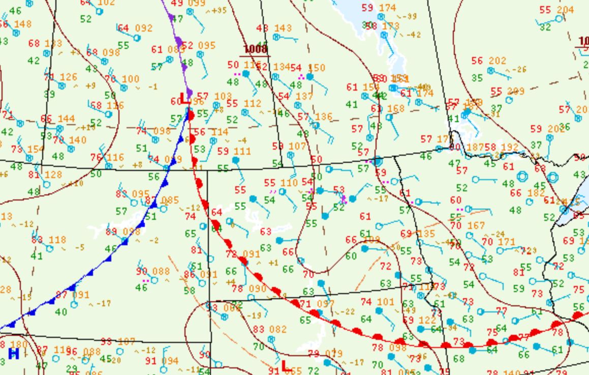
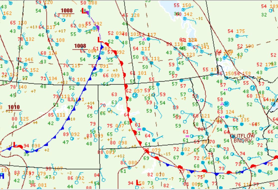
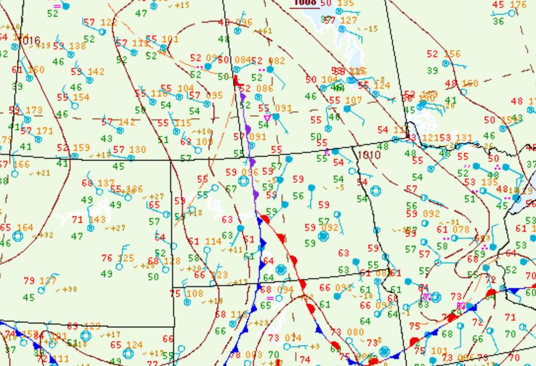
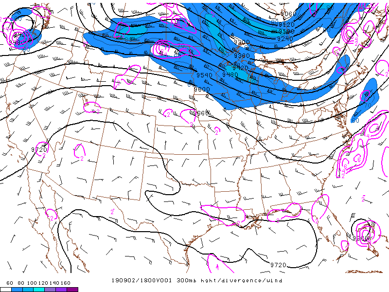
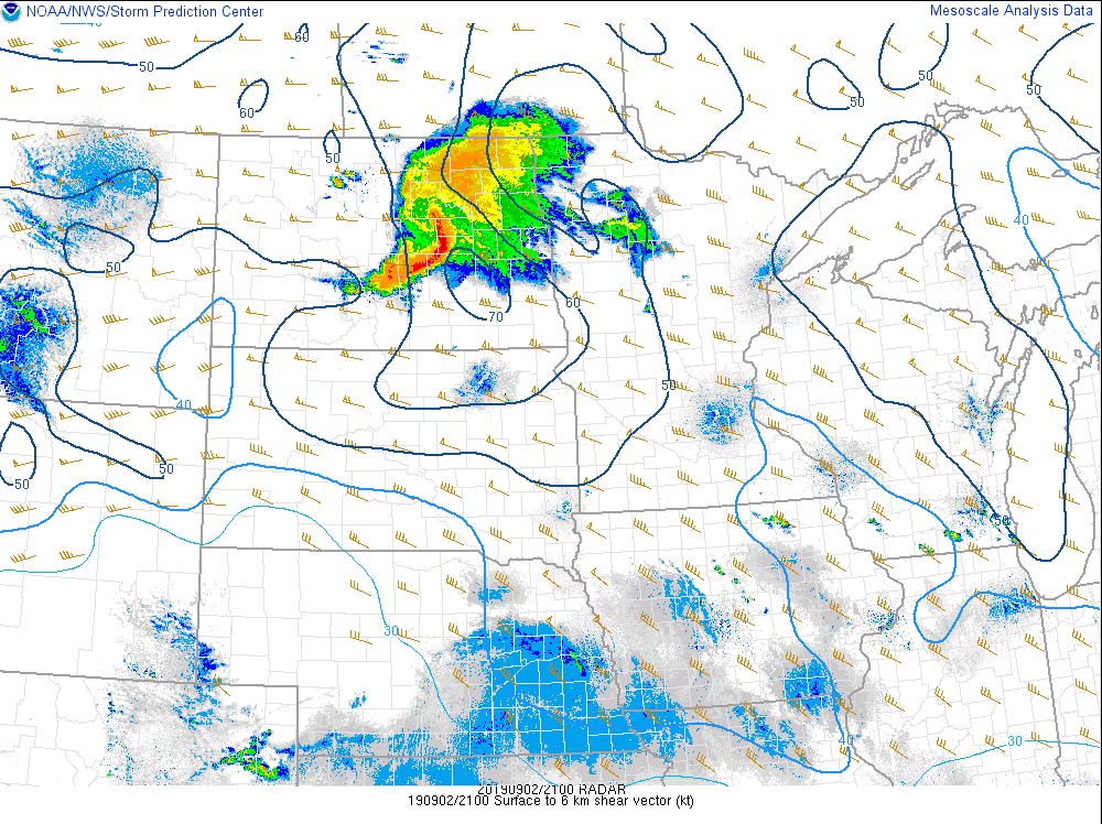
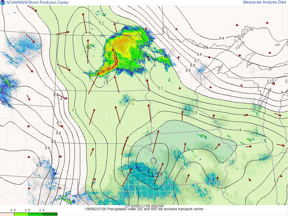
Initially, a warm frontal boundary was located to the south with low pressure centered over southern Saskatchewan. Throughout the day, storms formed north of the warm front with the low pressure slowly drifting eastward. At the 700mb level, a shortwave was moving across the County Warning Area with increased 700-500mb RH values. At 300mb, the upper-level divergence over northwestern North Dakota followed the jet eastward, which enhanced thunderstorm development during the afternoon hours. Storms followed the bulk shear vectors to progress to the ESE. Surface to 6 km shear values of 50 to 70 knots remained ahead of the line through the event. At the 850mb level, higher moisture south of the area was advected northward ahead of the upper-level shortwave. Precipitable water values were near 1.25 inches across the entire area. Downdraft CAPE values in excess of 800 J/kg were advected into southeastern North Dakota and parts of west central Minnesota, which provided an environment for damaging winds.
 |
 |
 |
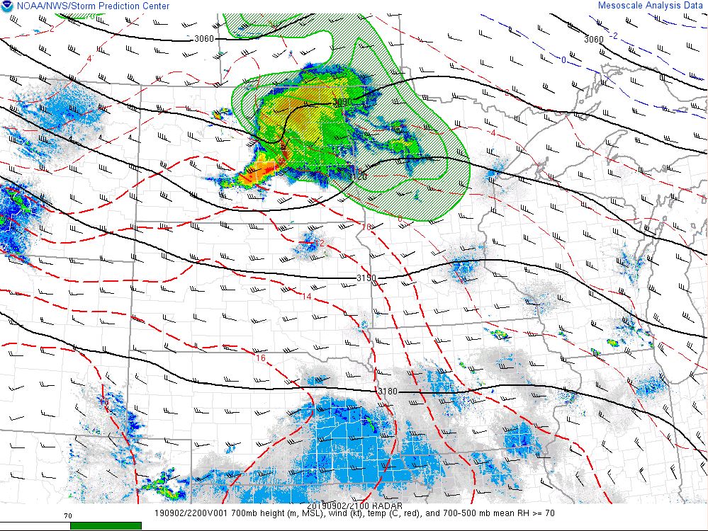 |
| Surface Analysis at 4:00 p.m. | Surface Analysis at 7:00 p.m. | Surface Analysis at 10:00 p.m. | 700mb Heights, Winds, Temps, and 700-500mb RH at 4:00 p.m. |
 |
 |
 |
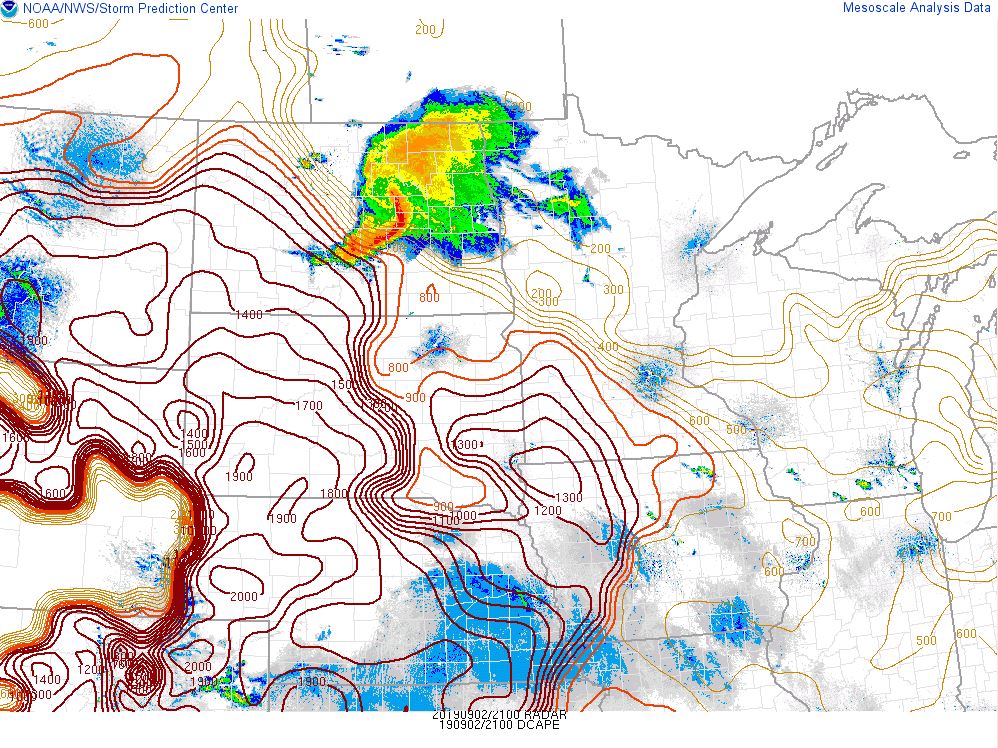 |
| 300mb Heights, Winds, and Divergence at 1:00 p.m. | Surface to 6 km Shear at 4:00 p.m. | Precipitable Water and 850mb Moisture Transport at 4;00 p.m. | Downdraft CAPE at 4:00 p.m. |
 |
Media use of NWS Web News Stories is encouraged! Please acknowledge the NWS as the source of any news information accessed from this site. |
|

