Overview
|
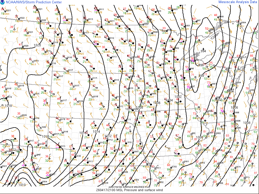
An severe weather outbreak unfolded across central and north-central Wisconsin during the afternoon and early evening of Friday, April 17, 2026. The event was triggered by a surface low-pressure system and cold front across the upper Midwest. This system drew unusually high moisture into the region for April, with dew points climbing into the lower 60s into central Wisconsin. The combination of this moisture and strong wind shear created a volatile corridor of instability immediately ahead of an approaching cold front. Storms began to develop in the mid-afternoon, taking the form of supercells and fast-moving line segments traveling northeast at 50 mph. The peak of the severe weather occurred between 3 pm and 7 pm, primarily concentrated over central Wisconsin where the atmosphere was most conducive to storm growth. As the activity pushed into eastern Wisconsin, the intensity and tornado threat began to diminish, as the storms encountered more stable, cooler air influenced by Lake Michigan. |
 |
|
Several confirmed tornadoes that resulted in structural damage. A NWS storm survey found a tornado formed 3 miles northwest of Glandon around 4:42pm and tracked into southeast Lincoln Co. Another tornado formed 3 miles west- southwest of Ringle in Marathon County around 4:46pm. Local emergency management in Weston confirmed damage to homes and mobilized fire department units to the scene. Up to 75 houses in Ringle were also damaged. Further west, strong radar rotation prompted tornado warnings in northern Wood County near Lindsey and Marshfield. Funnel clouds were also sighted across a broad area, including Stevens Point, Merrill, and portions of Langlade County near Phlox and White Lake. |
Beyond the tornadic threat, the storms produced isolated large hail. Heavy rainfall was another impact, with localized totals ranging from 1 to 4 inches. These torrential downpours caused flash flooding, particularly in Marshfield where 2.65 inches of rain fell. Emergency dispatchers there reported multiple vehicles stranded in deep water on city streets. The severe threat subsided by 8 pm as the storms moved east and weakened.
|
Tornadoes
Select a tornado from the table to zoom into the track and view more information. The default table view is limited to 8 tracks, but can be scrolled by a mouse wheel or dynamically expanded. Additionally, the table can fill the entire window by clicking the small circular expanding arrow icon at the very top right of the table and returned to its original size by clicking the button again. The side information panel that opens over the map can be closed using the "X" on the upper right corner of the pop-up. Zoom into the map and click damage points to see detailed information and pictures from the surveys.
|
NOTE: times shown below are local to your device's time zone. |

The Enhanced Fujita (EF) Scale classifies tornadoes into the following categories:
| EF0 Weak 65-85 mph |
EF1 Moderate 86-110 mph |
EF2 Significant 111-135 mph |
EF3 Severe 136-165 mph |
EF4 Extreme 166-200 mph |
EF5 Catastrophic 200+ mph |
 |
|||||
| Tornadoes that fail to impact any ratable damage indicators on the EF-Scale are rated EF-Unknown (EF-U) | |||||
Storm Reports
Preliminary Local Storm Report...Summary
National Weather Service Green Bay WI
1222 AM CDT Sat Apr 18 2026

..TIME...   ...EVENT...      ...CITY LOCATION...     ...LAT.LON...
..DATE...   ....MAG....      ..COUNTY LOCATION..ST.. ...SOURCE....
            ..REMARKS..

0340 PM     Tstm Wnd Gst     2 ENE Bakerville        44.64N 90.19W
04/17/2026  M51 MPH          Wood               WI   ASOS

            Apr 17, 3:40 pm 64 61 88 S 28G51 0.50 Hvy
            rain, Fog.

0350 PM     Hail             2 S Hewitt              44.60N 90.13W
04/17/2026  E0.70 Inch       Wood               WI   Public

            weather spotter called in saying 3 miles
            south of marsfeild dime size hail.

0439 PM     Funnel Cloud     1 SW Evergreen          44.83N 89.66W
04/17/2026                   Marathon           WI   Trained Spotter
0442 PM     Tornado          3 NW Glandon            45.10N 89.48W
04/17/2026                   Marathon           WI   NWS Storm Survey

            Path length of 4.33 miles. Estimated width
            of 100 yards. Peak wind 110 mph (EF1).
0446 PM Tornado 3 WSW Ringle 44.84N 89.57W
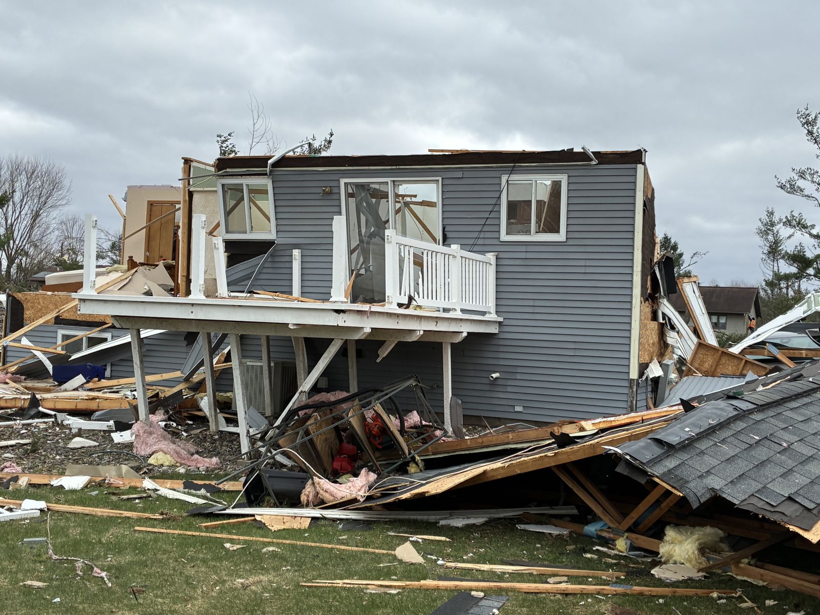
04/17/2026 Marathon WI NWS Storm Survey
Corrects previous tornado report from 3 WSW
Ringle. Ringle Tornado. The tornado
developed about 3 miles west-southwest of
Ringle, near County Road J and Weston
Avenue, at about 4:46 pm. The tornado moved
northeast, crossing highway 29 and downing
hundreds of trees. It then moved through
neighborhoods along and near River Road from
Shady Lane to north of Clubhouse Road. In
this area, dozens of homes suffered
significant roof damage, with failures of
attached garages common. At least three
homes in this area had complete removal of
their roofs with failure of all external
walls and several interior walls, consistent
with EF-3 damage. Hundreds more trees were
downed in this area, with many snapped near
the base. Multiple sheds and outbuildings
were destroyed. The tornado continued
northeast, closely following the Eau Claire
River, and dissipated between Gold Dust Road
and County Road Z, 5 miles southwest of
Hogarty, at about 5:03 pm. There have been
no reported injuries or fatalities. Path
length was 13.53 miles. Estimated width of
600 yards. Peak wind 145 mph (EF3).
0451 PM     Tornado          1 SE Weston             44.89N 89.55W
04/17/2026                   Marathon           WI   Fire Dept/Rescue

            Damage to houses.

0455 PM     Funnel Cloud     1 S Jeffris             45.49N 89.43W
04/17/2026                   Lincoln            WI   Trained Spotter

            Seen funnel cloud in area with strong winds
            and rain.

0505 PM     Tornado          1 SSW Ringle            44.89N 89.41W
04/17/2026                   Marathon           WI   Trained Spotter

            Caller said tornado on ground going north
            east.

0515 PM     Funnel Cloud     5 NNW Stevens Point     44.58N 89.60W
04/17/2026                   Portage            WI   Law Enforcement

            Sheriff office called saying officers have
            seen funnel cloud going over I39.
0529 PM     Tstm Wnd Dmg     4 WSW Phelps            46.03N 89.16W
04/17/2026                   Vilas              WI   Public

            Time estimated by radar. Trees and power
            lines down on Moore Lane southwest of
            Phelps. Also Trees and power lines down on
            Hwy 17 in the area. Possible tornado,
            spotted by public. Reports relayed from
            Vilas County Sheriff.
0538 PM     Funnel Cloud     1 NNW Phlox             45.05N 89.01W
04/17/2026                   Langlade           WI   911 Call Center

            call center called to report a funnel cloud
            going north east of Phlox.

0540 PM     Funnel Cloud     4 WNW Elton             45.17N 88.92W
04/17/2026                   Langlade           WI   911 Call Center

            Langlade dispatch called saying funnel cloud
            seen southwest of Elton.

0619 PM     Funnel Cloud     2 SSW White Lake        45.13N 88.78W
04/17/2026                   Langlade           WI   911 Call Center

            Call from Shawano county dispatch reporting
            funnel cloud by white lake.

0625 PM     Flash Flood      1 NW Marshfield         44.67N 90.17W
04/17/2026                   Wood               WI   911 Call Center

            getting reports of cars stuck in water on
            several streets with in Marshfield.

0641 PM     Flood            4 N Moon                44.81N 89.78W
04/17/2026                   Marathon           WI   Trained Spotter

            Hog Creek on Hog Creek Road is flooded and
            culverts are washed out.

0705 PM     Flood            2 N Wausau              44.98N 89.64W
04/17/2026                   Marathon           WI   Public

            Street flooding. Also, law enforcement
            reports minor poor drainage flooding in the
            area.

0709 PM     Hail             Lake Tomahawk           45.81N 89.59W
04/17/2026  M0.70 Inch       Oneida             WI   Public


0744 PM     Non-Tstm Wnd Gst 3 W Ashwaubenon         44.49N 88.13W
04/17/2026  M55 MPH          Brown              WI   ASOS

            At the Green Bay Airport.
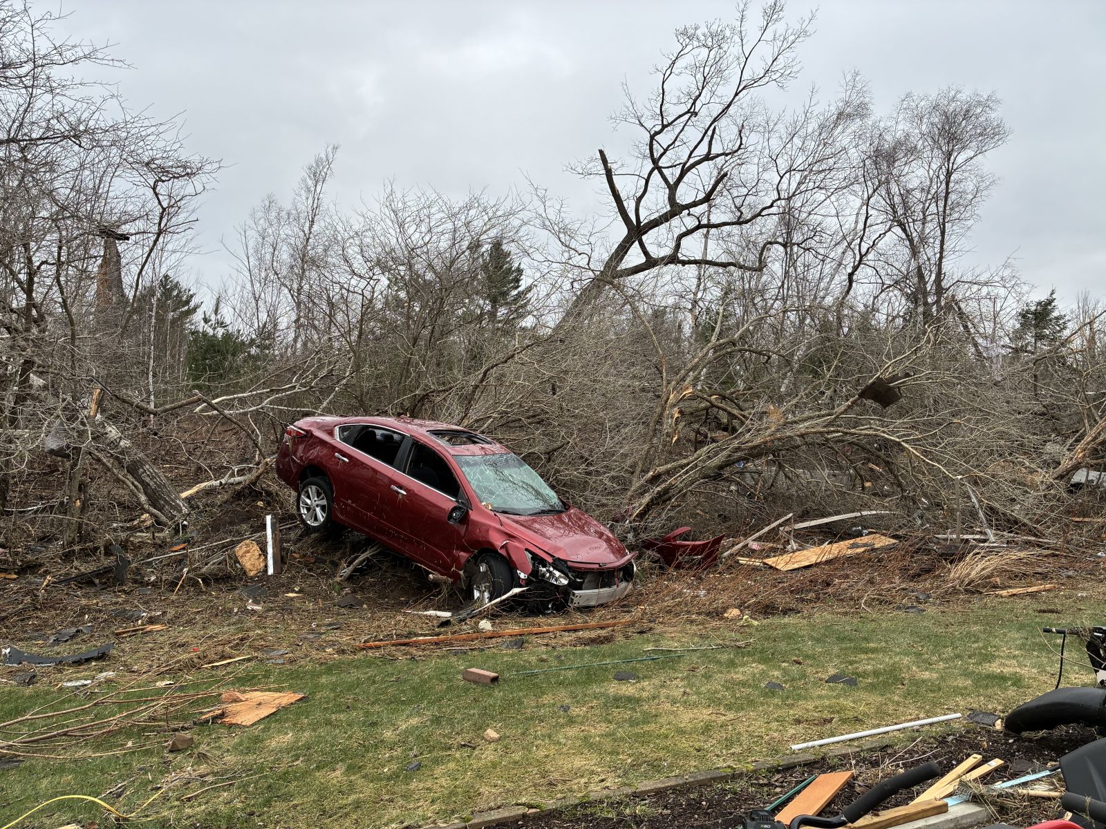
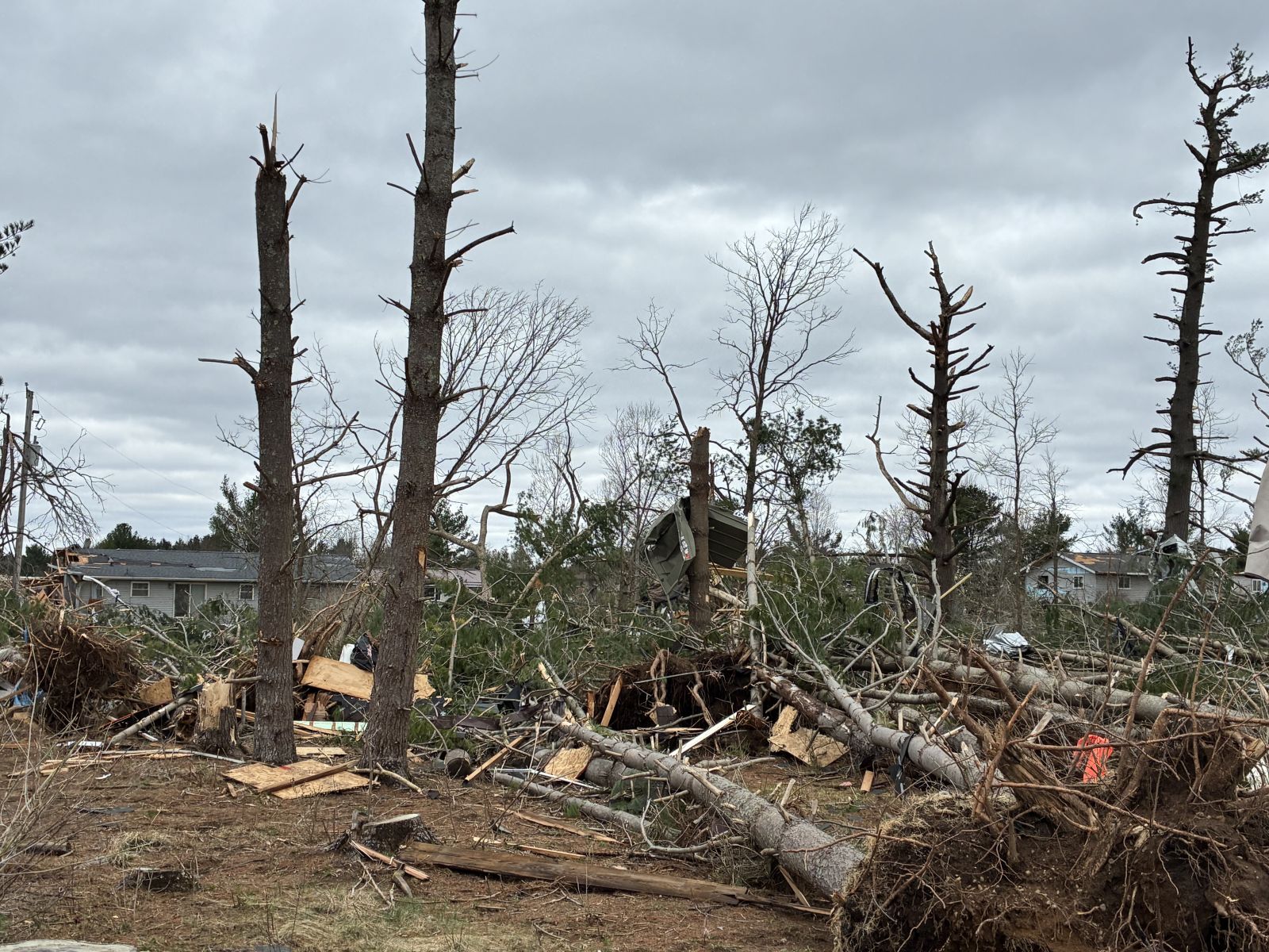
Photos & Video
 |
 |
 |
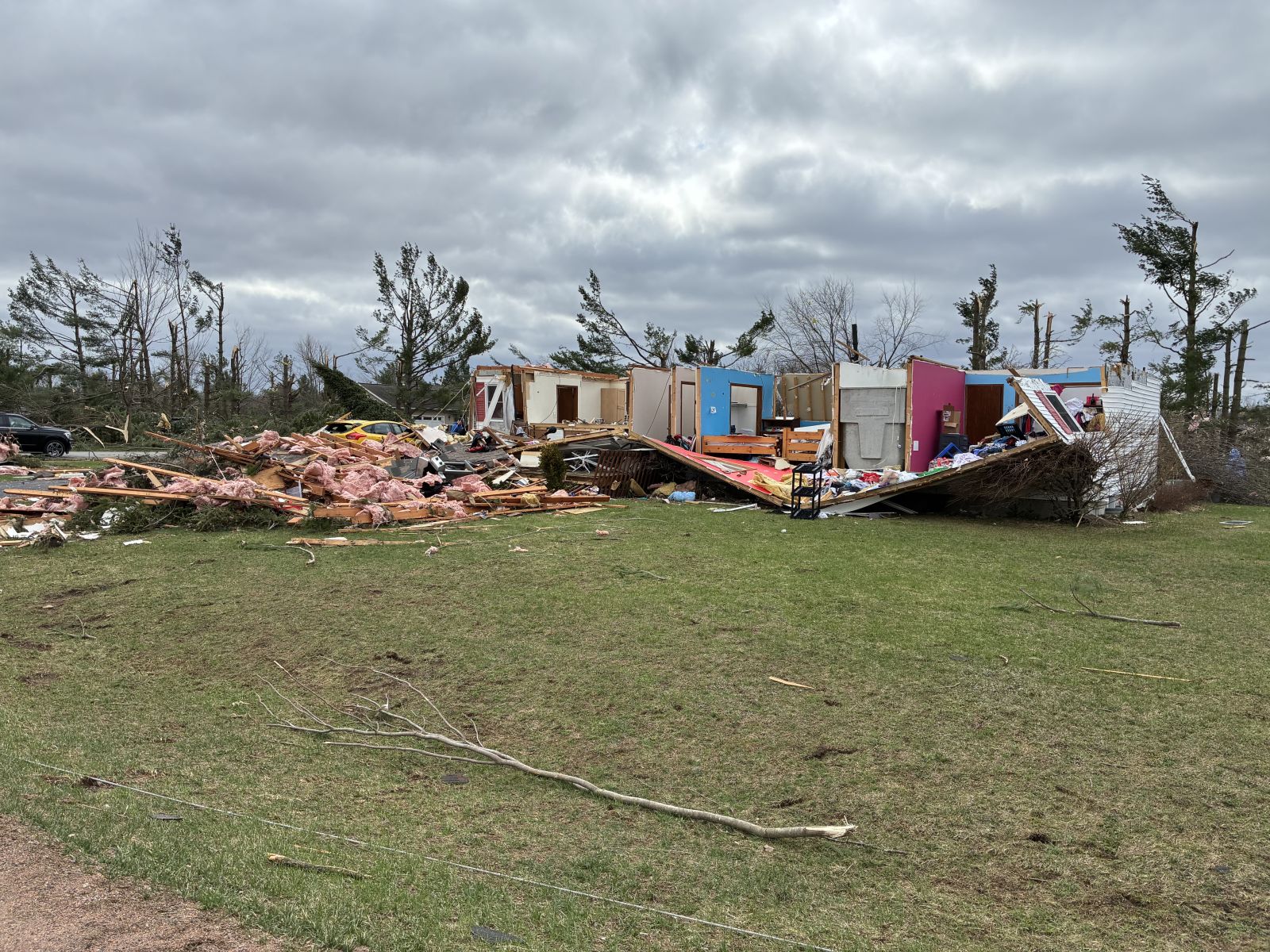 |
| Ringle, WI (NWS Storm Survey) |
Ringle, WI (NWS Storm Survey) |
Ringle, WI (NWS Storm Survey) |
Ringle, WI (NWS Storm Survey) |
 |
 |
||
| Kronenwetter, WI (NWS Storm Survey) |
Kronenwetter, WI (NWS Storm Survey) |
, WI (NWS Storm Survey) |
, WI (NWS Storm Survey) |
Radar
 |
 |
 |
|
|
Radar animation (2 pm - 8:30 pm) |
Reflectivity and Storm Relative Velocity (4:49 pm) | Reflectivity and Storm Relative Velocity (4:51 pm) |
Environment
 |
 |
|
| Green Bay radiosonde (1 pm Apr 17) | GOES visible satellite (4 pm Apr 17) |
Near-storm environment summary.
 |
 |
 |
| Surface observations at 4 pm | Surface-based CAPE (instability) at 4 pm | Effective storm relative helicity (wind shear) at 4 pm |
Services
 |
 |
 |
| Graphic showing the severe weather risk during the afternoon of April 17 | Graphic showing timing for severe storms on April 17 | Short term graphic indicating storm timing |
Additional Event Summaries:
 |
Media use of NWS Web News Stories is encouraged! Please acknowledge the NWS as the source of any news information accessed from this site. |
|

