Overview
|
Tropical system Cristobal, that originated in the Gulf of America, quickly moved northward during a two day period from 7pm Monday June 8 through 7 am Wednesday June 10. Although the system weakened to a tropical depression as it moved onshore over the southern Mississippi Valley, it still brought copious amounts of moisture into the western Great Lakes region late Tuesday afternoon. The system moved quickly over the region and by 7am Wednesday the center of the circulation was located over southern Lake Superior, well on its way out of the area. Primary impacts associated with the remnants of Cristobal were heavy rainfall and strong winds. Twenty-four hour storm total rainfall amounts, from Tuesday to 7 am Wednesday ranged from less than an inch over eastern Wisconsin to locally 4-5 inches over southeast Minnesota and SW Wisconsin (see precipitation map below). Flooding was reported over many areas across NE Iowa, SE Minnesota and SW Wisconsin. Areas further east across central and eastern Wisconsin only minor flooding was noted. In addition, this system had record low pressure for the month of June, which allowed for widespread wind gusts in the range of 30-50 mph. The impacts from Cristobal could have been far worse. Had the system been slower in crossing the region, the ample moisture available would have created much more widespread significant flooding concerns. Fortunately, Cristobal was relatively fast moving, which prevented the overall rainfall totals (and associated impacts) from being much higher across the Western Great Lakes region. For details, see the tabs below.
Storm Total Rainfall from Tuesday through Wednesday morning. |
|
|
Environment:
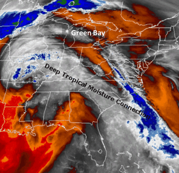 |
Image:GOES-16 Water Vapor Given its tropical origins, it should not be surprising that Cristobal carried along with it copious and deep moisture. This GOES-16 Water Vapor animation illustrates this tropical connection. Note the band of light gray colors extending from the southeast United States northwest to the upper Midwest. This feature in water vapor imagery is sometimes is referred to as a tropical moisture plume (tropical connection). It represents very deep moisture that was available to Cristobal as it moved northward into the western Great Lakes region. |
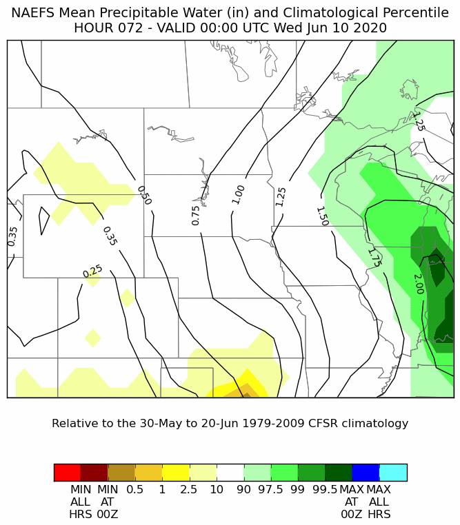 |
Image – blended model ensemble forecast of precipitable water (PW). These consecutive ensemble model forecasts are all valid for the same time (7 pm Tuesday June 9, 2020). Even from a climatological perspective for early June, the moisture this system carried with it was extreme! The amount of moisture in the atmosphere that is available for a system can be measured by its Precipitable Water content (PW). Note the bright cyan colors that appear over Wisconsin as early as 48 hours before the event began to impact the state. This indicates that the model guidance was forecasting available moisture (PW) to be the highest ever observed for early June in the western Great Lakes region! Analysis such as these are an invaluable to forecasters, as it helps to put the model forecasts into a climatological perspective; and aid in gauging the potential for, and abnormality of, an extreme weather event. |
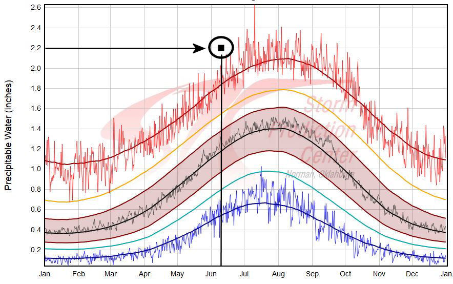 |
Image - Storm Prediction Center annual precipitable water content soundings
In the image to the left, in red are the maximum observed precipitable water contents, in black is the average (normal), and in blue are the minimum observed. Plotted with the black dot is the observed PW value from the 7 PM June 10th upper air sounding observation. Note that the measured PW value of 2.2 inches is the highest ever observed for this time in early June in Green Bay! |
Storm Track:
 |
Image – National Hurricane Center (NHC) forecast track from Monday June 8th, 2020.
|
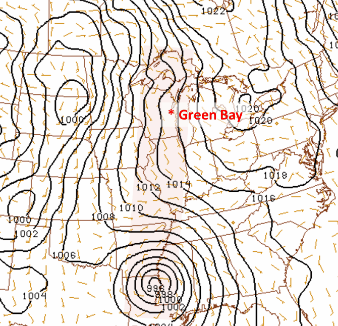 |
Image - Observed track of the low pressure system. Note how well the NHC forecast compared to the actual observed track! This is only the third time since 1900 that the remnants of a tropical system tracked directly across the state of Wisconsin. It is also interesting to note that not only did Cristobal bring record moisture to Wisconsin, but also, record surface low pressure! In fact, the observed surface pressure recorded at Green Bay, Wisconsin fell to 986 mb (29.12 in Hg) early Wednesday morning, which is a new low pressure record for the month of June! |
Radar & Rainfall Reports:
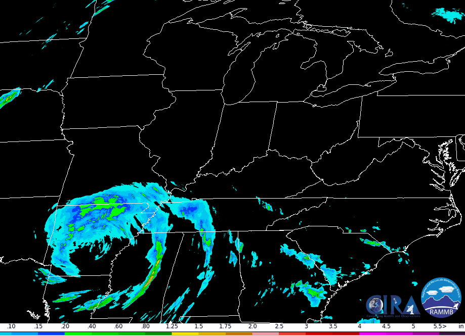 |
Image - Composite radar analysis of 1 hourly estimated rainfall. The green colors indicate where the heaviest rain was falling (1-2 inches/hour) with respect to the center of Cristobal. Note that the heaviest rain fell generally to the west and northwest of the storm track over parts of far northeast Iowa, far southeast Minnesota, and from southwest to north-central Wisconsin. |
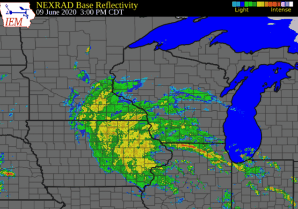 |
Image – Radar Composite Animation. A close-up animation of the radar data as the storm impacted Wisconsin between 4 pm Tuesday and 4 am Wednesday.
|
Public Information Statement
National Weather Service Green Bay WI
1116 AM CDT Wed Jun 10 2020

...PRECIPITATION REPORTS >0.70 INCHES OVER THE PAST 24 HOURS ENDING AT 11 AM...

Location                     Amount    Time/Date       Provider

...Wisconsin...

...Brown County...
Denmark WWTP                 0.74 in   0800 AM 06/10   COOP

...Door County...
1.9 NW Carlsville            0.98 in   0630 AM 06/10   UCOOP
Fish Creek 1 E WWTP          0.85 in   0430 AM 06/10   UCOOP
Potawatomi State Park 4 ESE  0.74 in   1059 AM 06/10   AWS

...Florence County...
Florence                     1.60 in   0700 AM 06/10   COOP
Spread Eagle 1 NW            0.95 in   0700 AM 06/10   COCORAHS

...Forest County...
Argonne 1.5 NW               2.30 in   0707 AM 06/10   COOP
Wabeno 2 NNW                 1.87 in   1001 AM 06/10   RAWS
Crandon                      1.39 in   1055 AM 06/10   CWOP

...Kewaunee County...
Casco 0.4 NNW                0.97 in   0530 AM 06/10   COCORAHS
Kewaunee                     0.95 in   0700 AM 06/10   COOP

...Langlade County...
White Lake 1.4 SE            2.27 in   0800 AM 06/10   COOP
Summit Lake                  1.90 in   0500 AM 06/10   COOP
Antigo 1 SSW                 1.72 in   0800 AM 06/10   COOP
Antigo 2 ENE                 1.68 in   1005 AM 06/10   RAWS

...Lincoln County...
Merrill 7 W                  2.97 in   0600 AM 06/10   COCORAHS
Merrill Airport              2.30 in   1035 AM 06/10   AWOS
0.7 N Bradley                2.30 in   0700 AM 06/10   COOP
Bradley 1.0 NE               2.30 in   0700 AM 06/10   COOP
2.7 NE Spirit Falls          2.11 in   0930 AM 06/10   UCOOP

...Manitowoc County...
Shoto 1 NW                   1.30 in   0700 AM 06/10   COCORAHS
Reedsville                   1.04 in   1045 AM 06/10   CWOP
Manitowoc Airport            1.02 in   0956 AM 06/10   AWOS
Mishicot 0.1 NNW             1.00 in   0800 AM 06/10   COCORAHS
Two Rivers 4.1 WNW           0.99 in   0645 AM 06/10   COCORAHS
Manitowoc                    0.85 in   1053 AM 06/10   CWOP
Two Rivers                   0.83 in   0715 AM 06/10   COOP

...Marathon County...
Mosinee 2 W                  2.63 in   0700 AM 06/10   COCORAHS
Stratford 6.4 NW             2.17 in   0700 AM 06/10   COCORAHS
Mosinee                      2.12 in   1050 AM 06/10   CWOP
Knowlton                     2.09 in   1050 AM 06/10   CWOP
Dancy 1 NNW                  2.09 in   0700 AM 06/10   COCORAHS
Wausau                       2.07 in   1052 AM 06/10   CWOP
Wausau 2.2 NE                2.06 in   0530 AM 06/10   COCORAHS
Wausau Airport               1.98 in   0954 AM 06/10   ASOS
Wausau                       1.98 in   0700 AM 06/10   UCOOP
Moon 1 E                     1.95 in   0700 AM 06/10   COOP
Evergreen 1.5 WSW            1.92 in   0700 AM 06/10   COCORAHS
Spencer - Wwtp               1.90 in   0730 AM 06/10   UCOOP
Weston 1 NE                  1.80 in   0700 AM 06/10   COCORAHS
Evergreen 1 E                1.73 in   0700 AM 06/10   COCORAHS

...Marinette County...
Athelstane 6 SW              1.23 in   0700 AM 06/10   COOP
Athelstane 1.6 E             1.13 in   0600 AM 06/10   UCOOP
Quinnesec 1 S                1.00 in   1059 AM 06/10   AWS
1.6 NW Wausaukee             0.90 in   0800 AM 06/10   COOP
Wausaukee 2 NW               0.85 in   1005 AM 06/10   RAWS

...Menominee County...
Keshena 2 WNW                1.40 in   1005 AM 06/10   RAWS
Keshena 4 NE                 0.93 in   1100 AM 06/10   AWS

...Oconto County...
Townsend 1.7 NNW             2.10 in   0600 AM 06/10   COCORAHS
Mountain                     1.73 in   1053 AM 06/10   CWOP
Lakewood                     1.64 in   1033 AM 06/10   CWOP
Mountain 0.9 E               1.45 in   0700 AM 06/10   COCORAHS
Breed 5 NE                   1.42 in   1003 AM 06/10   RAWS
Suring                       1.13 in   0700 AM 06/10   COOP

...Oneida County...
Minocqua 6.0 W               3.15 in   0700 AM 06/10   COCORAHS
Minocqua                     3.04 in   0630 AM 06/10   COOP
Mc Naughton 3 SSE            2.85 in   0600 AM 06/10   COCORAHS
Rhinelander 5 N              2.79 in   0830 AM 06/10   COCORAHS
Hazelhurst 2.1 SSE           2.78 in   0700 AM 06/10   COCORAHS
Rhinelander 4 NE             2.75 in   0600 AM 06/10   COOP
Arbor Vitae - Woodruff 2 S   2.75 in   1010 AM 06/10   RAWS
Bradley 2 NNW                2.65 in   0700 AM 06/10   COCORAHS
Rhinelander Airport          2.55 in   1053 AM 06/10   ASOS
Tomahawk 3 W                 2.53 in   1010 AM 06/10   RAWS
Bradley 2 NNW                2.29 in   1053 AM 06/10   CWOP

...Outagamie County...
New London 4.1 N             1.42 in   0600 AM 06/10   COCORAHS
Shiocton 0.6 NW              1.10 in   0730 AM 06/10   COOP
Hortonville 3.3 WSW          1.01 in   0902 AM 06/10   COCORAHS
New London 2 SE              0.98 in   0630 AM 06/10   COOP
Black Creek 3 NW             0.97 in   0600 AM 06/10   COCORAHS
Greenville                   0.92 in   1057 AM 06/10   CWOP
Appleton                     0.83 in   1007 AM 06/10   RAWS
Seymour                      0.77 in   1045 AM 06/10   CWOP
Appleton 2.2 NW              0.77 in   0415 AM 06/10   COCORAHS

...Portage County...
Almond 5 NE                  1.88 in   0800 AM 06/10   UCOOP
Almond 6.7 ENE               1.77 in   0700 AM 06/10   COCORAHS
Amherst 3 SE                 1.69 in   0700 AM 06/10   UCOOP
Plover                       1.50 in   1047 AM 06/10   CWOP
Stevens Point                1.49 in   0700 AM 06/10   COOP
Rosholt                      1.48 in   0720 AM 06/10   COOP
Rudolph 1 NNE                1.44 in   0500 AM 06/10   COCORAHS
Plover 1.8 W                 1.37 in   0700 AM 06/10   COCORAHS

...Shawano County...
Split Rock 1 NNW             2.08 in   0800 AM 06/10   COCORAHS
Stockbridge-Munsee Reservati 1.77 in   0830 AM 06/10   COOP
Bowler 1 WNW                 1.59 in   1100 AM 06/10   AWS
Pella 3 SE                   1.04 in   0530 AM 06/10   UCOOP
Shawano 2 SSW                0.93 in   0800 AM 06/10   COOP
Bonduel 3.3 NW               0.78 in   0700 AM 06/10   COCORAHS

...Vilas County...
St Germain 0.6 NW            3.02 in   0600 AM 06/10   COOP
Eagle River - South          2.93 in   0659 AM 06/10   UCOOP
0.6 S Manitowish Waters      2.90 in   0830 AM 06/10   COOP
Phelps 2 SW                  2.79 in   1002 AM 06/10   RAWS
Boulder Junction 1.4 NE      2.65 in   0700 AM 06/10   COCORAHS
Winchester                   2.58 in   1051 AM 06/10   CWOP
Boulder Junction 9 ENE       2.57 in   0700 AM 06/10   COCORAHS
Arbor Vitae Airport          2.47 in   1035 AM 06/10   AWOS
4.2 N Phelps                 2.12 in   0841 AM 06/10   COOP
Manitowish Waters Airport    2.09 in   1035 AM 06/10   AWOS
Land O Lakes                 1.79 in   1035 AM 06/10   AWOS

...Waupaca County...
Ogdensburg 2 E               1.56 in   0700 AM 06/10   COCORAHS
Waupaca 5.7 WSW              1.49 in   0730 AM 06/10   COCORAHS
Waupaca                      1.32 in   1031 AM 06/10   CWOP
Clintonville 0.9 N           1.28 in   0700 AM 06/10   COOP
New London - WWTP            1.08 in   0700 AM 06/10   UCOOP
3.8 NE Lind Center           1.05 in   0800 AM 06/10   HADS
Clintonville Airport         0.96 in   1035 AM 06/10   AWOS

...Waushara County...
Almond 4.7 SE                1.66 in   0700 AM 06/10   COCORAHS
Wild Rose 0.5 E              1.26 in   0700 AM 06/10   COCORAHS
Coloma                       1.20 in   1054 AM 06/10   CWOP
Wautoma 5.5 NE               0.81 in   0852 AM 06/10   COCORAHS
Wautoma 3 SE                 0.79 in   0830 AM 06/10   COOP

...Winnebago County...
Zittau                       1.04 in   0600 AM 06/10   UCOOP
Oshkosh                      0.78 in   0700 AM 06/10   COOP
Oshkosh 2.0 W                0.78 in   0700 AM 06/10   COCORAHS
1.5 W Menasha                0.75 in   1000 AM 06/10   HADS
Larsen 4 ENE                 0.74 in   1059 AM 06/10   AWS

...Wood County...
Marshfield 3.0 WSW           2.30 in   0900 AM 06/10   COCORAHS
Pittsville - WWTP            2.20 in   0700 AM 06/10   UCOOP
Babcock 0.6 W                2.09 in   0700 AM 06/10   COCORAHS
Vesper                       1.89 in   1007 AM 06/10   CWOP
New Rome 3 WNW               1.86 in   0700 AM 06/10   COCORAHS
Marshfield 1.0 WNW           1.85 in   0700 AM 06/10   COCORAHS
0.8 N Hewitt                 1.84 in   0730 AM 06/10   COOP
Marshfield Airport           1.54 in   1038 AM 06/10   AWOS
New Rome 4 ENE               1.53 in   1005 AM 06/10   RAWS
Port Edwards 2 WNW           1.46 in   1046 AM 06/10   CWOP
Wisconsin Rapids Airport     1.39 in   0954 AM 06/10   ASOS
Kellner 3 WNW                1.39 in   0615 AM 06/10   COCORAHS
Port Edwards 2 E             1.29 in   0700 AM 06/10   COCORAHS
Wisconsin Rapids 1 ESE       1.23 in   1100 AM 06/10   AWS
Port Edwards 1 SE            1.16 in   0700 AM 06/10   UCOOP
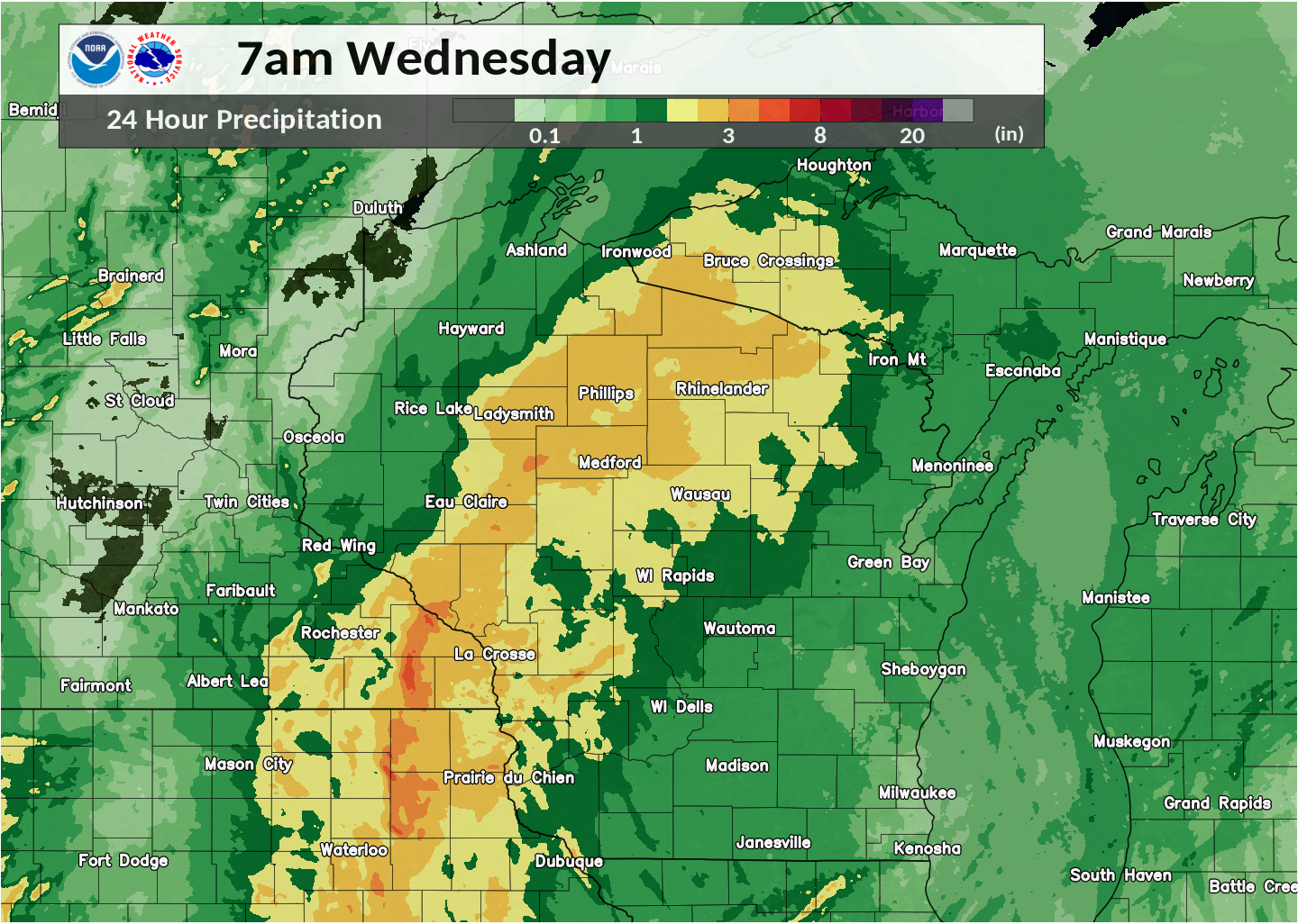
Shown below is the 24 hour precipitation totals:
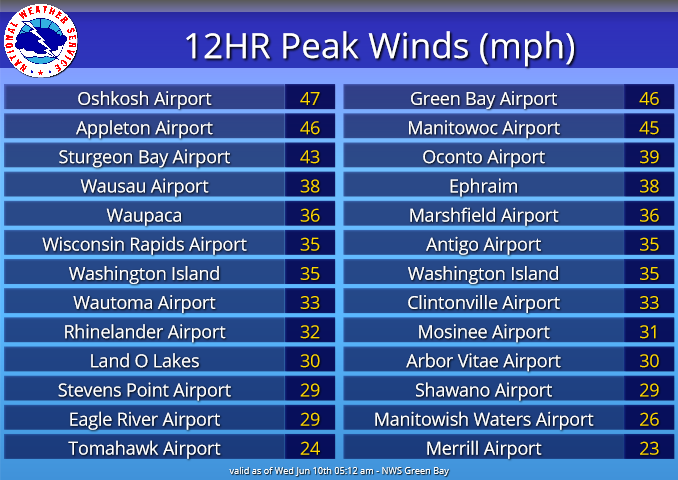
Wind Reports
 |
Media use of NWS Web News Stories is encouraged! Please acknowledge the NWS as the source of any news information accessed from this site. |
|

