Overview
|
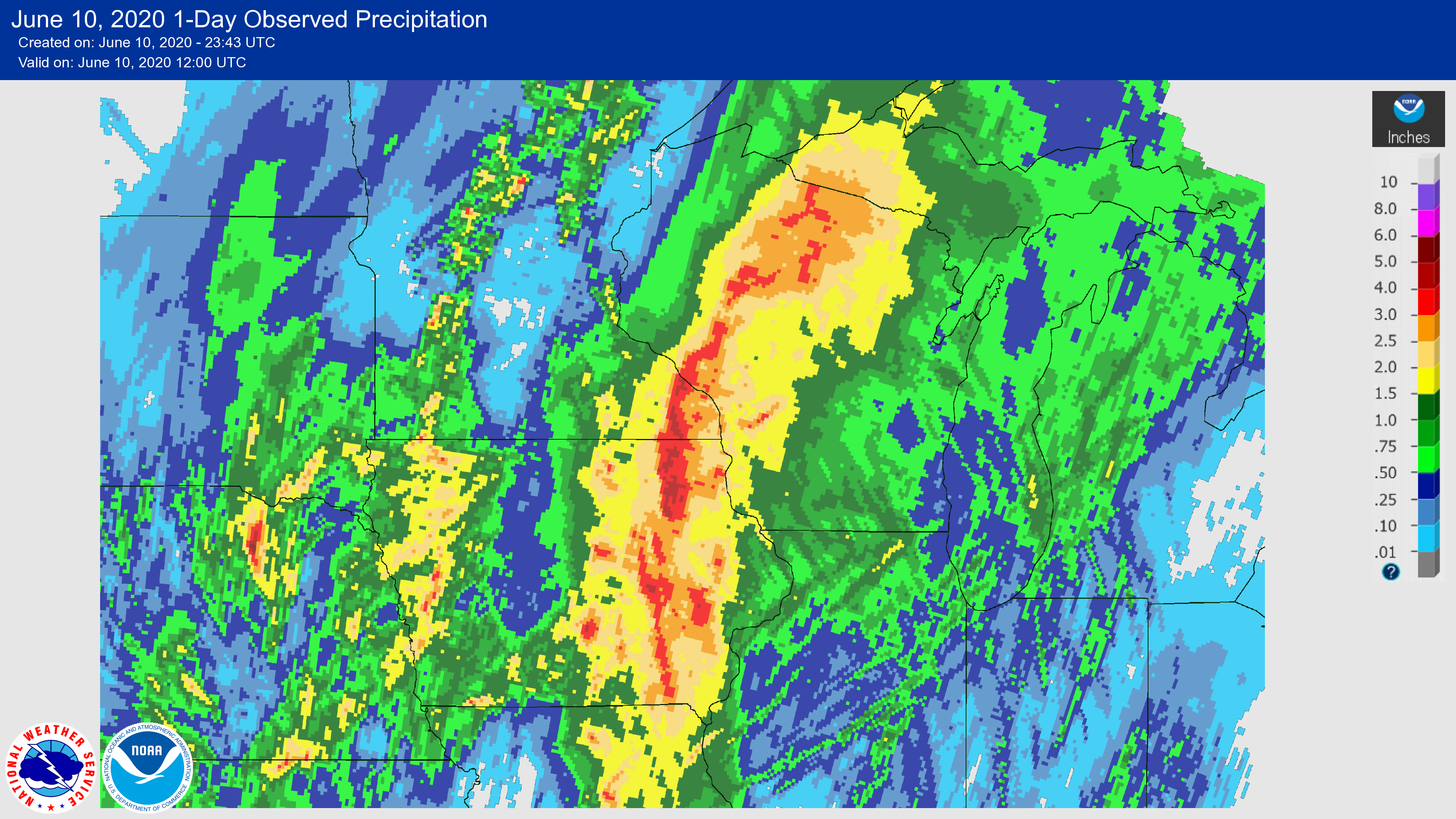
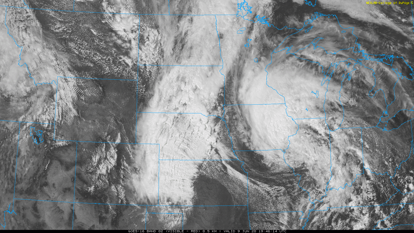
Tropical Depression Cristobal moved into the region from the south during the afternoon of June 9, 2020. It brought with it heavy rainfall that produced widespread 1-3 inches of rainfall, with some localized amounts exceeding 5 inches. This heavy rain led to flash flooding, mudslides, and rapid rises on some area rivers. This was only the 2nd time on record that a tropical weather system center tracked through Iowa, and only the 3rd time it crossed part of Wisconsin. You can view history of tropical storm systems in our area via - weather.gov/arx/tropical
|
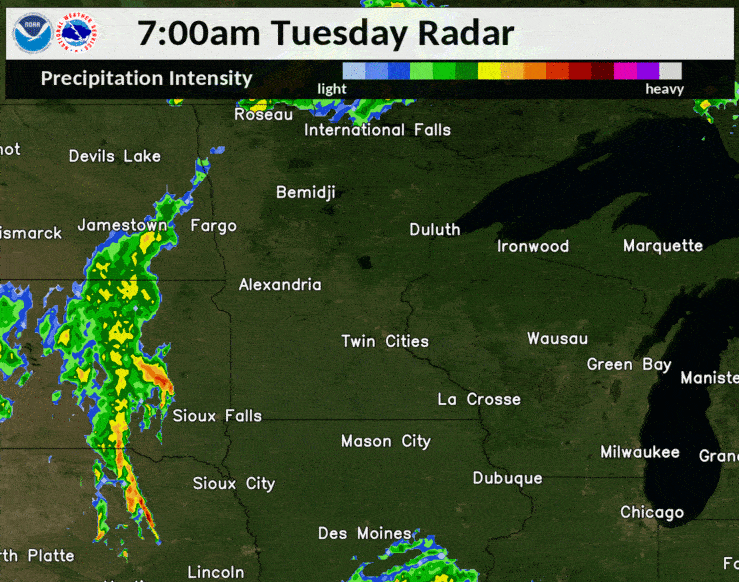 Radar Loop of June 9, 2020 |
Flooding
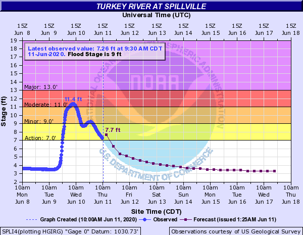
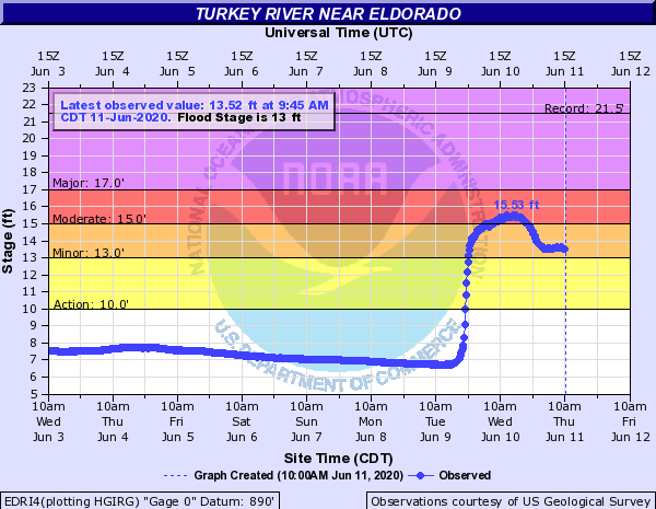
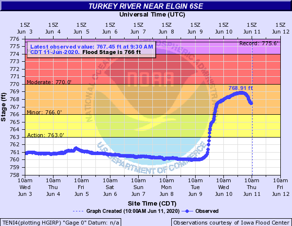
Hydrographs
 |
 |
 |
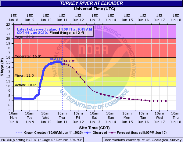 |
| Turkey River at Spillville, IA | Turkey River at Eldorado, IA | Turkey River at Elgin, IA | Turkey River at Elkader, IA |
 |
 |
 |
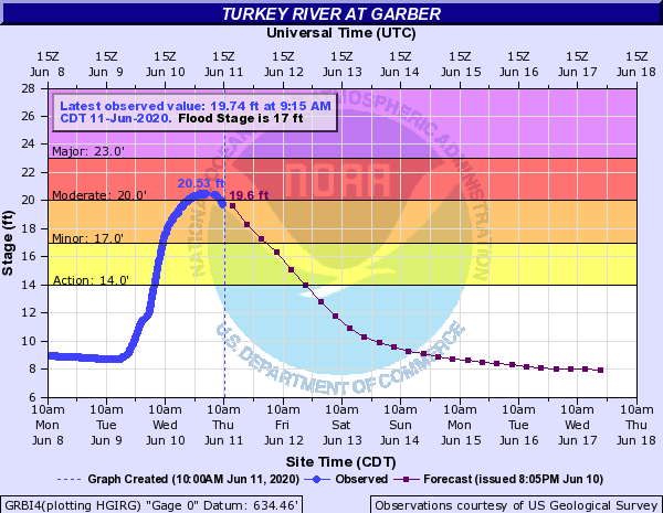 |
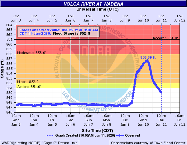
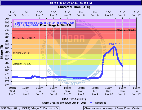
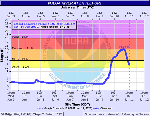
| Volga River at Wadena, IA | Volga River at Volga, IA | Volga River at Littleport, IA | Turkey River at Garber, IA |
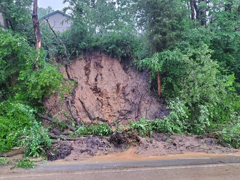
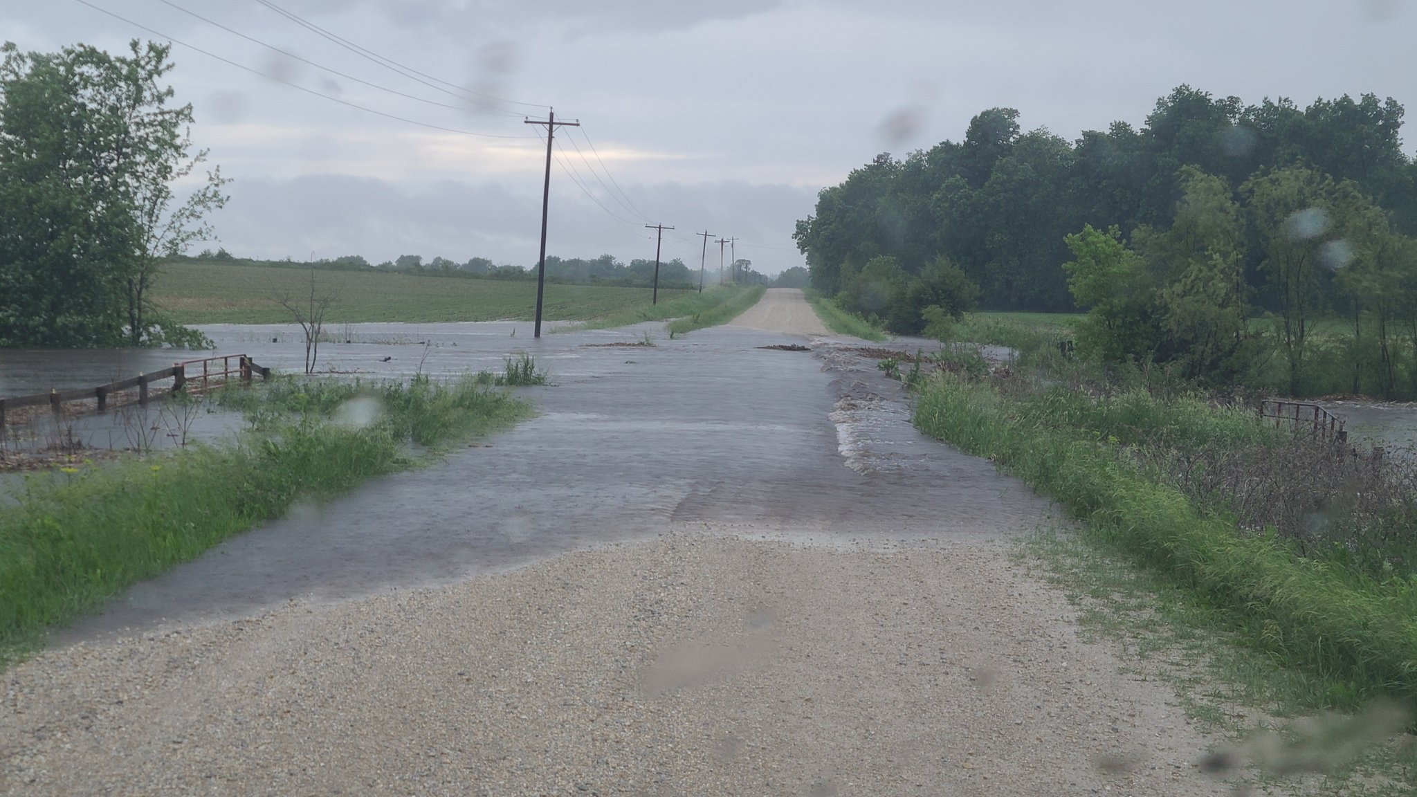
Flooding Reports
PRELIMINARY LOCAL STORM REPORT...SUMMARY
NATIONAL WEATHER SERVICE LA CROSSE WI
747 AM CDT WED JUN 10 2020
..TIME... ...EVENT... ...CITY LOCATION... ...LAT.LON...
..DATE... ....MAG.... ..COUNTY LOCATION..ST.. ...SOURCE....
..REMARKS..
0625 PM FLASH FLOOD OELWEIN 42.68N 91.91W
06/09/2020 FAYETTE IA EMERGENCY MNGR
REPORTS OF ROADS IN THE TOWN OF OELWEIN
FLOODED. HWY 3 JUST WEST OF OELWEIN BETWEEN
COUNTY ROADS X & Y IS CLOSED DUE TO
FLOODING.
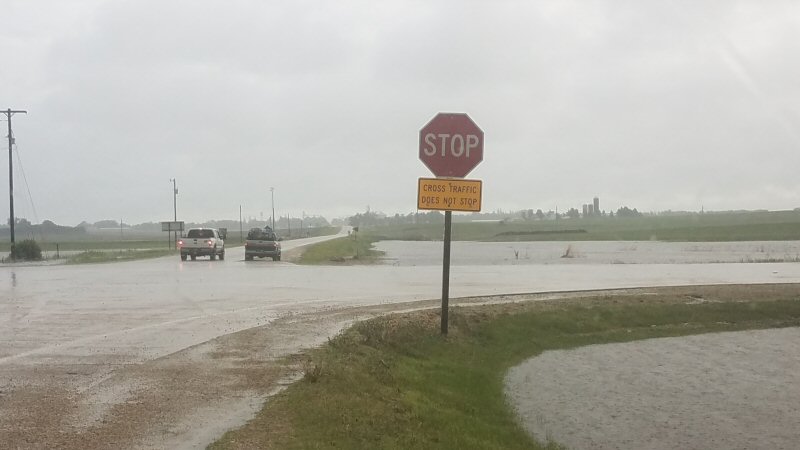
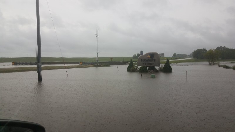
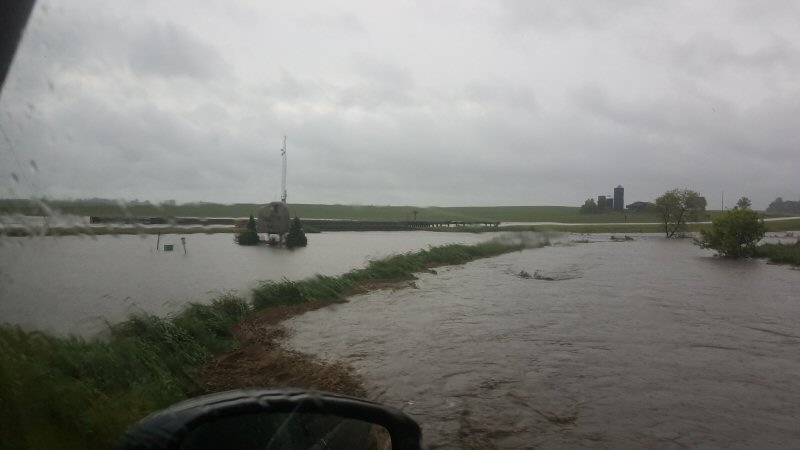
0700 PM FLASH FLOOD HAWKEYE 42.94N 91.95W
06/09/2020 FAYETTE IA EMERGENCY MNGR
EMERGENCY MANAGER REPORTS NUMEROUS ROAD
CLOSURES DUE TO HIGH WATER ACROSS FAYETTE
COUNTY, INCLUDING 190TH ST. EAST OF HAWKEYE,
Q AVE., 90TH ST. SOUTH OF FAYETTE, HWY 150,
AND OLD HWY 150 N.
0710 PM FLASH FLOOD 3 S FAYETTE 42.79N 91.81W
06/09/2020 FAYETTE IA EMERGENCY MNGR
ROAD CLOSED DUE TO HIGH WATER.
0710 PM FLASH FLOOD 5 ESE MAYNARD 42.76N 91.78W
06/09/2020 FAYETTE IA EMERGENCY MNGR
90TH STREET CLOSED DUE TO HIGH WATER.
0724 PM FLASH FLOOD 3 N MAYNARD 42.82N 91.88W
06/09/2020 FAYETTE IA PUBLIC
PICTURE SENT ON SOCIAL MEDIA OF WATER
FLOWING OVER ROADWAY.
0800 PM FLASH FLOOD 2 W PROTIVIN 43.21N 92.12W
06/09/2020 HOWARD IA LAW ENFORCEMENT
EARLIER ROAD CLOSURE DUE TO HIGH WATER AT
100TH ST. AND WILLOW AVE. WATER HAS SINCE
RECEDED.
0821 PM FLASH FLOOD 1 W WHALAN 43.74N 91.95W
06/09/2020 FILLMORE MN LAW ENFORCEMENT
MUDSLIDE REPORTED ON HIGHWAY 16, 3 MILES
EAST OF LANESBORO.
0830 PM FLASH FLOOD ELBA 44.09N 92.02W
06/09/2020 WINONA MN LAW ENFORCEMENT
MUDSLIDE NEAR ELBA AND WHITEWATER STATE
PARK. MUDSLIDES ALSO REPORTED NEAR WINONA
BRINGING DOWN POWER POLES.
0830 PM FLASH FLOOD 3 ESE LAWLER 43.05N 92.10W
06/09/2020 CHICKASAW IA LAW ENFORCEMENT
HIGH WATER REPORTED OVER 210TH ST AND
WINDSOR ST, STEVENS ROAD, AND 120TH ST IN
NORTHEAST CHICKASAW COUNTY.
0849 PM FLASH FLOOD 1 S LEWISTON 43.97N 91.87W
06/09/2020 WINONA MN EMERGENCY MNGR
HIGH WATER OVER ROAD AT CO HWY 29 AND CO HWY
106 NEAR LEWISTON.
0910 PM FLASH FLOOD FOUNTAIN CITY 44.12N 91.70W
06/09/2020 BUFFALO WI PUBLIC
RECEIVED A PHOTO AND REPORT OF WATER COMING
UP TO THE BOTTOM OF THE DOORFRAME OF A
HOUSE. RESIDENT SAYS WATER IS COMING INTO
THE HOUSE.
0915 PM FLASH FLOOD ARCADIA 44.25N 91.49W
06/09/2020 TREMPEALEAU WI LAW ENFORCEMENT
ARCADIA IS PUTTING OUT CONES FOR FLOODING O
CLEVELAND ST.
0924 PM FLASH FLOOD 2 S GOODVIEW 44.04N 91.72W
06/09/2020 WINONA MN EMERGENCY MNGR
REPORT OF A MUDSLIDE AND TREE DOWN ON HWY 14
BETWEEN WINONA AND STOCKTON.
0948 PM FLASH FLOOD 1 ESE WHALAN 43.73N 91.92W
06/09/2020 FILLMORE MN LAW ENFORCEMENT
REPORT OF MUDSLIDE.
1206 AM FLASH FLOOD ARCADIA 44.26N 91.50W
06/10/2020 TREMPEALEAU WI PUBLIC
1235 AM FLASH FLOOD GILMAN 45.17N 90.81W
06/10/2020 TAYLOR WI TRAINED SPOTTER
SPOTTER REPORTS UP TO A FOOT OF WATER
COVERING SEVERAL ROADS IN TOWN.
1236 AM FLASH FLOOD GILMAN 45.16N 90.81W
06/10/2020 TAYLOR WI TRAINED SPOTTER
REPORTS OF WATER OVER SOME ROADS IN THE
GILMAN AREA AND WESTERN TAYLOR CO.
&&
Photos:
 |
 |
 |
 |
| Fayette, IA (credit: Zander Britt ) |
Fayette, IA (credit: Zander Britt) |
Fayette, IA (credit: Zander Britt ) |
Lanesboro, MN (Photo by MnDOT Dist.6) |
 |
|||
| Near Maynard, IA (credit: Chad Ingels) |
Rain Reports
Public Information Statement
National Weather Service La Crosse WI
1100 AM CDT Wed Jun 10 2020

...24 HOUR RAINFALL TOTALS...

Location                     Amount    Time/Date       Lat/Lon

...IOWA...

...Allamakee County...
4 SE Lansing                 3.20 in   0715 AM 06/10   43.33N/91.16W
Harpers Ferry 6.4 SSW        2.42 in   0700 AM 06/10   43.11N/91.20W
Waukon 3N                    2.25 in   0623 AM 06/10   43.31N/91.46W
Postville 5.5 NE             2.21 in   0700 AM 06/10   43.14N/91.49W
Monona 9.8 N                 2.08 in   0700 AM 06/10   43.19N/91.35W
Lansing 4.1 NW               1.74 in   0700 AM 06/10   43.40N/91.29W
5 SW Waukon Jct              1.41 in   0515 AM 06/10   43.11N/91.27W

...Chickasaw County...
Ionia 2W                     3.03 in   0500 AM 06/10   43.03N/92.50W
New Hampton 0.4 SW           2.18 in   0700 AM 06/10   43.06N/92.32W
New Hampton                  2.00 in   0700 AM 06/10   43.06N/92.31W

...Clayton County...
Big Spring Fish Hatchery     2.65 in   0600 AM 06/10   42.91N/91.47W
McGregor                     2.61 in   0749 AM 06/10   43.02N/91.19W
Garber                       2.39 in   0515 AM 06/10   42.74N/91.26W
Monona                       2.31 in   0749 AM 06/10   43.04N/91.39W
Volga 1NE                    2.28 in   0601 AM 06/10   42.81N/91.52W
Elkader 6SSW                 2.06 in   0700 AM 06/10   42.78N/91.45W
Guttenberg Dam 10            1.74 in   0600 AM 06/10   42.79N/91.10W
1 WSW Marquette              1.63 in   0615 AM 06/10   43.04N/91.21W
Littleport                   1.43 in   0500 AM 06/10   42.75N/91.37W

...Fayette County...
Oelwein 2E                   5.25 in   1200 AM 06/10
Maynard 2W                   4.60 in   0800 AM 06/10
Fayette                      4.50 in   0700 AM 06/10   42.88N/91.83W
Waucoma 3.2 S                4.24 in   0700 AM 06/10   43.01N/92.03W
West Union                   3.83 in   0830 AM 06/10
Waucoma 1 WNW                3.80 in   0700 AM 06/10   43.06N/92.05W
Eldorado 1E - Turkey River   2.58 in   0630 AM 06/10   43.05N/91.81W

...Floyd County...
Nora Springs 2.4 SSE         3.10 in   0700 AM 06/10   43.11N/92.99W
Charles City                 2.30 in   0700 AM 06/10   43.06N/92.67W

...Howard County...
Elma                         2.21 in   0700 AM 06/10   43.24N/92.44W
Saratoga                     2.00 in   0601 AM 06/10   43.35N/92.42W
Riceville                    1.87 in   0746 AM 06/10   43.36N/92.48W

...Mitchell County...
St Ansgar                    2.60 in   0630 AM 06/10   43.38N/92.92W
Osage                        2.30 in   0845 PM 06/09   43.28N/92.81W
St.Ansgar                    2.24 in   0744 AM 06/10   43.38N/92.92W
Osage 4.7 E                  1.62 in   0700 AM 06/10   43.28N/92.72W

...Winneshiek County...
Ridgeway 5NW                 4.40 in   1000 AM 06/10
4 ESE Bluffton               3.90 in   0641 PM 06/10   43.39N/91.84W
1 ENE Bluffton               3.21 in   0600 AM 06/10   43.41N/91.90W
Spillville                   3.06 in   0700 AM 06/10   43.21N/91.95W
7 ENE Decorah                2.91 in   0716 AM 06/10   43.34N/91.64W
Decorah 4.9SE                2.88 in   0700 AM 06/10   43.26N/91.70W
Decorah                      2.74 in   0545 AM 06/10   43.30N/91.80W
1 ENE Jackson Junction       1.93 in   0750 AM 06/10   43.11N/92.04W

...MINNESOTA...

...Dodge County...
Hayfield 0.3 SSE             1.86 in   0730 AM 06/10   43.89N/92.85W
Hayfield                     1.69 in   0747 AM 06/10   43.89N/92.85W
Wasioja (IFLOWS)             1.61 in   0348 AM 06/10   44.07N/92.82W
Mantorville 1WNW             1.30 in   0800 AM 06/10   44.07N/92.77W
Mantorville 1.9 ESE          1.26 in   0600 AM 06/10   44.05N/92.72W

...Fillmore County...
Whalan 1NE                   5.06 in   1200 PM 06/10
Lanesboro                    4.54 in   1230 AM 06/10   43.72N/91.98W
1 S Peterson                 3.68 in   0543 AM 06/10   43.78N/91.83W
Mabel                        3.34 in   0630 AM 06/10   43.52N/91.76W
Chatfield 9.0 ESE            3.31 in   0700 AM 06/10   43.79N/92.03W
Preston 3.2 NNE              2.85 in   0630 AM 06/10   43.71N/92.05W
3 ESE Canton                 2.34 in   0922 PM 06/09   43.52N/91.87W
2 S Pilot Mound              2.02 in   0700 AM 06/10   43.78N/92.03W
1 NNW Fillmore               1.90 in   0700 AM 06/10   43.76N/92.27W
Wykoff 3.1 NW                1.80 in   0700 AM 06/10   43.74N/92.31W
Preston Airport              1.50 in   0735 AM 06/10   43.68N/92.17W

...Houston County...
Freeburg 3SSW                3.50 in   0624 AM 06/10   43.57N/91.39W
Houston                      3.11 in   0746 AM 06/10   43.77N/91.58W
Spring Grove                 3.00 in   0800 PM 06/09   43.56N/91.64W
Caledonia                    3.00 in   0800 PM 06/09   43.63N/91.50W
Mound Prairie                2.71 in   0600 AM 06/10   43.78N/91.45W
La Crescent 5.4 SW           2.51 in   0700 AM 06/10   43.78N/91.39W
Hokah 4 NW                   2.28 in   0700 AM 06/10   43.80N/91.43W
La Crescent                  2.25 in   0800 AM 06/10
2 NE Mound Prairie           2.09 in   0730 PM 06/09   43.80N/91.43W
1 NNE Houston                2.07 in   0730 AM 06/10   43.77N/91.57W
La Crescent 1.0 WSW          2.01 in   0700 AM 06/10   43.83N/91.32W
1 SSE Brownsville            1.61 in   0915 PM 06/09   43.69N/91.27W

...Mower County...
Austin 3 NW - Turtle Creek   3.22 in   0700 AM 06/10   43.65N/92.98W
Austin 2.7 W                 2.53 in   0700 AM 06/10   43.68N/93.03W
Austin 2.4 W                 2.45 in   0700 AM 06/10   43.67N/93.02W
Austin 1.5 WSW               2.36 in   0700 AM 06/10   43.67N/93.00W
Ostrander 5.1 WNW            2.32 in   0700 AM 06/10   43.65N/92.52W
Austin 3S - Cedar River      2.28 in   0630 AM 06/10   43.64N/92.97W
4 WSW Austin                 1.50 in   0820 PM 06/09   43.64N/93.05W
Lansing - Cedar River        1.02 in   0600 AM 06/10   43.75N/92.96W

...Olmsted County...
Elgin 5SE                    2.59 in   0700 AM 06/10   44.08N/92.19W
Eyota 2NE                    2.47 in   0700 AM 06/10   44.02N/92.20W
1 W Chester                  2.39 in   0616 AM 06/10   44.00N/92.38W
3 ENE Rochester              2.26 in   0630 AM 06/10   44.03N/92.43W
Rochester 1.5 WSW            2.20 in   0700 AM 06/10   44.00N/92.50W
2 NE Rochester               2.20 in   0600 AM 06/10   44.04N/92.44W
3 N Rochester                2.19 in   0715 AM 06/10   44.06N/92.47W
Rochester                    2.14 in   0745 AM 06/10   44.04N/92.44W
Rochester-Beltline Bear Cree 1.97 in   0600 AM 06/10   44.01N/92.45W
Rochester                    1.96 in   0130 AM 06/10   44.04N/92.44W
Elba 4.7 SW                  1.86 in   1030 PM 06/09   44.04N/92.09W
2 NNW Rochester              1.84 in   0600 AM 06/10   44.05N/92.49W
Rochester International Airp 1.83 in   0746 AM 06/10   43.90N/92.50W
Rochester 5.8 ENE            1.75 in   0700 AM 06/10   44.06N/92.38W
Rochester 2.0 NNE            1.69 in   0700 AM 06/10   44.04N/92.47W
Rochester 4.2 N              1.68 in   0600 AM 06/10   44.08N/92.49W
Mayo Helipad                 1.50 in   0735 AM 06/10   44.02N/92.48W
Byron                        1.15 in   0830 PM 06/09   44.03N/92.65W

...Wabasha County...
Wabasha                      2.65 in   0748 AM 06/10   44.30N/92.00W
1 N Kellogg                  2.52 in   0530 AM 06/10   44.32N/92.00W
Plainview                    2.13 in   0746 AM 06/10   44.17N/92.17W
Zumbro Falls 3.5 SSW         1.37 in   0644 AM 06/10   44.24N/92.46W
3 SSW Lake City              1.20 in   0723 AM 06/10   44.40N/92.30W
Mazeppa                      1.19 in   0700 AM 06/10   44.27N/92.55W
3 ESE Mazeppa                1.11 in   0700 AM 06/10   44.26N/92.49W
Lake City                    1.09 in   0745 AM 06/10   44.44N/92.28W

...Winona County...
Winona 3S                    4.79 in   1200 AM 06/10
Lewiston 0.2 NW              4.62 in   0700 AM 06/10   43.99N/91.87W
Winona 5.1 WSW               4.54 in   0700 AM 06/10   44.03N/91.77W
Stockton 1.2 W               4.36 in   0608 AM 06/10   44.03N/91.79W
Minnesota City 1.1 SE        4.19 in   0700 AM 06/10   44.08N/91.73W
Winona 4SW                   3.75 in   0821 AM 06/10   43.98N/91.71W
Winona                       3.50 in   0805 PM 06/09   44.05N/91.66W
4.2 N Rollingstone           3.40 in   0600 AM 06/10   44.16N/91.81W
Winona Dam 5A                3.20 in   0600 AM 06/10   44.09N/91.67W
Goodview                     3.20 in   0930 PM 06/09   44.07N/91.71W
Winona 12.0 ESE              3.13 in   0700 AM 06/10   43.99N/91.44W
Dakota                       2.90 in   0700 AM 06/10   43.91N/91.36W
Winona 2SE                   2.87 in   0800 AM 06/10
Whitewater State Park        2.35 in   0700 AM 06/10   44.05N/92.05W
La Crescent Dam 7            2.30 in   0600 AM 06/10   43.87N/91.31W
Beaver                       2.30 in   0500 AM 06/10   44.15N/92.00W
1 WSW Elba                   2.23 in   0700 AM 06/10   44.09N/92.03W
3 SW Elba                    2.10 in   0630 AM 06/10   44.06N/92.05W
Saint Charles                1.30 in   0750 AM 06/10   43.97N/92.06W

...WISCONSIN...

...Adams County...
Nekoosa 8.0 SSE              2.01 in   0700 AM 06/10   44.21N/89.85W
Oxford 4.0 W                 1.19 in   0700 AM 06/10   43.79N/89.64W
Grand Marsh 1.0 W            1.14 in   0700 AM 06/10   43.89N/89.73W

...Buffalo County...
Cochrane                     3.87 in   0800 AM 06/10   44.22N/91.84W
Mondovi 12.1 SSE             3.66 in   0700 AM 06/10   44.40N/91.60W
Fountain City                3.00 in   0730 PM 06/09   44.12N/91.70W
Mondovi                      2.45 in   0600 PM 06/10
Alma Dam 4                   2.21 in   0600 AM 06/10   44.33N/91.92W

...Clark County...
Owen 1E                      3.12 in   0700 AM 06/10   44.95N/90.55W
Chili 6NNE                   1.50 in   0700 AM 06/10   44.71N/90.34W
Colby 5.9 WSW                0.60 in   0700 PM 06/09   44.87N/90.42W

...Crawford County...
Prairie Du Chien 1.4 N       1.94 in   0700 AM 06/10   43.06N/91.14W
0.6 NE Prairie Du Chien      1.90 in   0700 AM 06/10   43.05N/91.13W
Prairie Du Chien  Airport    1.64 in   0735 AM 06/10   43.02N/91.12W
Gays Mills 1.0 NE            1.59 in   0700 AM 06/10   43.33N/90.84W
2.8 E Harpers Ferry          1.41 in   0945 PM 06/09   43.21N/91.10W
Steuben                      1.36 in   0615 AM 06/10   43.18N/90.86W
Gays Mills                   1.15 in   0700 AM 06/10   43.32N/90.85W
Steuben 4SE                  1.12 in   0624 AM 06/10   43.13N/90.84W
De Soto                      1.05 in   0746 AM 06/10   43.42N/91.19W
2.8 E Harpers Ferry          0.88 in   0700 AM 06/10   43.21N/91.10W

...Grant County...
Glen Haven                   1.80 in   0845 PM 06/09   42.83N/91.07W
Muscoda                      1.71 in   0745 AM 06/10   43.19N/90.46W
Sinsinawa                    1.62 in   0900 AM 06/10   42.52N/90.54W
Woodman                      1.55 in   0800 AM 06/10   43.10N/90.80W
Lancaster                    1.53 in   0741 AM 06/10   42.83N/90.69W
Fennimore                    1.12 in   0750 AM 06/10   42.98N/90.66W
Platteville                  1.07 in   0746 AM 06/10   42.74N/90.46W
Platteville Municipal Airpor 0.97 in   0735 AM 06/10   42.68N/90.43W
Boscobel                     0.83 in   0703 AM 06/10   43.15N/90.68W
Boscobel Airport             0.79 in   0653 AM 06/10   43.15N/90.68W

...Jackson County...
Black River Falls 1W         2.70 in   0830 AM 06/10   44.30N/90.86W
Black River Falls 1.7 NNE    2.19 in   0700 AM 06/10   44.32N/90.83W
Black River Falls Area Airpo 1.78 in   0735 AM 06/10   44.25N/90.85W
1 E Black River Falls        1.40 in   0715 AM 06/10   44.30N/90.73W
Mather 3NW                   1.34 in   0700 AM 06/10   44.17N/90.35W

...Juneau County...
New Lisbon                   1.82 in   0715 AM 06/10   43.87N/90.17W
Volk Field                   1.80 in   0656 AM 06/10   43.92N/90.27W
Mauston                      1.51 in   0747 AM 06/10   43.80N/90.07W
Mauston Airport              1.34 in   0735 AM 06/10   43.83N/90.13W
Necedah                      1.32 in   0748 AM 06/10   44.03N/90.08W
0.6 W Necedah                1.32 in   0548 AM 06/10   44.02N/90.08W
2 N Cloverdale               1.13 in   0600 AM 06/10   44.06N/90.17W

...La Crosse County...
Onalaska                     3.20 in   1000 AM 06/10
Holmen 6.9 N                 2.59 in   0700 AM 06/10   44.06N/91.27W
NWS La Crosse                2.38 in   0105 AM 06/10   43.82N/91.19W
La Crosse                    2.28 in   0708 AM 06/10   43.82N/91.19W
Holmen 2S                    2.12 in   0700 AM 06/10   43.93N/91.25W
La Crosse 4.4 SSE            2.09 in   0700 AM 06/10   43.77N/91.21W
La Crosse 5.3 E              2.03 in   0700 AM 06/10   43.82N/91.13W
La Crosse Regional Airport   1.91 in   0753 AM 06/10   43.88N/91.25W
St. Joseph 3W                1.74 in   0446 AM 06/10   43.80N/91.10W
Coon Valley 4.5 NNW          1.66 in   0700 AM 06/10   43.76N/91.06W

...Monroe County...
Wilton 4.2 E                 2.44 in   0700 AM 06/10   43.81N/90.44W
5 NE Wilton                  1.77 in   0739 AM 06/10   43.87N/90.46W
Tomah 1W                     1.75 in   0800 AM 06/10   43.99N/90.52W
Tomah 5NNW                   1.75 in   0800 AM 06/10   44.04N/90.55W
2 E Cataract                 1.74 in   0748 AM 06/10   44.09N/90.79W
Cashton 3 NNW                1.59 in   0730 AM 06/10   43.79N/90.80W
Sparta 3SSW                  1.55 in   0402 AM 06/10   43.90N/90.83W
Sparta/Fort McCoy Airport    1.41 in   0655 AM 06/10   43.97N/90.73W

...Richland County...
1 SSE Richland Center        1.66 in   0749 AM 06/10   43.32N/90.38W

...Taylor County...
3 NE Lublin                  3.33 in   0714 AM 06/10   45.11N/90.69W
Medford 1N                   2.80 in   0930 AM 06/10   45.16N/90.35W
Goodrich 6W                  2.76 in   0800 AM 06/10   45.14N/90.20W
Medford                      2.74 in   0746 AM 06/10   45.30N/90.30W
2 N Dorchester               2.68 in   0428 AM 06/10   45.04N/90.33W
Medford 0.8 ENE              2.52 in   0700 AM 06/10   45.14N/90.33W
Medford Airport              2.15 in   0735 AM 06/10   45.10N/90.30W

...Trempealeau County...
1 NW Trempealeau             3.20 in   0700 AM 06/10   44.03N/91.46W
Galesville 2WSW              3.15 in   0600 AM 06/10   44.07N/91.39W
Trempealeau 7.6 NNW          3.12 in   0700 AM 06/10   44.11N/91.48W
Trempealeau Dam 6            3.00 in   0800 AM 06/10   44.00N/91.44W
Ettrick 4.0 WNW              2.98 in   0555 AM 06/10   44.19N/91.34W
Ettrick 3.2 NE               2.90 in   0700 AM 06/10   44.20N/91.23W
Galesville 1.0 NE            2.88 in   0530 AM 06/10   44.10N/91.34W
Trempealeau                  2.52 in   0746 AM 06/10   44.07N/91.51W
Blair (IFLOWS)               2.33 in   1034 PM 06/09   44.30N/91.23W
Arcadia                      2.10 in   0816 PM 06/09   44.25N/91.49W
0.8 SW Pigeon Falls (IFLOWS) 1.93 in   1034 PM 06/09   44.42N/91.22W

...Vernon County...
Genoa Dam 8                  2.83 in   0100 AM 06/10   43.57N/91.23W
Retreat                      2.50 in   0458 AM 06/10   43.45N/91.08W
Viroqua 0.8 ESE              2.10 in   0700 AM 06/10   43.55N/90.87W
La Farge                     1.85 in   0700 AM 06/10   43.57N/90.63W
Hillsboro 0.5 WSW            1.69 in   0700 AM 06/10   43.65N/90.35W
Viroqua Municipal Airport    1.68 in   0755 AM 06/10   43.58N/90.90W

Observations are collected from a variety of sources with varying
equipment and exposures. We thank all volunteer weather observers
for their dedication. Not all data listed are considered official.

$$
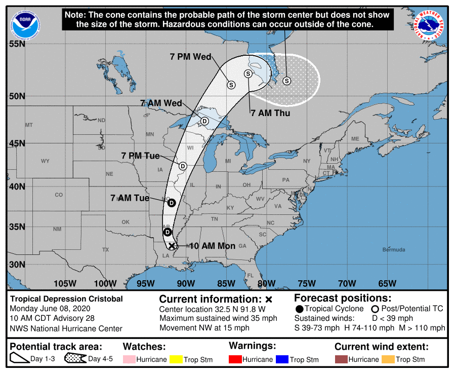
Tropical Storm Cristobal
National Hurricane Center "Cristobal" summary
 |
 |
 |
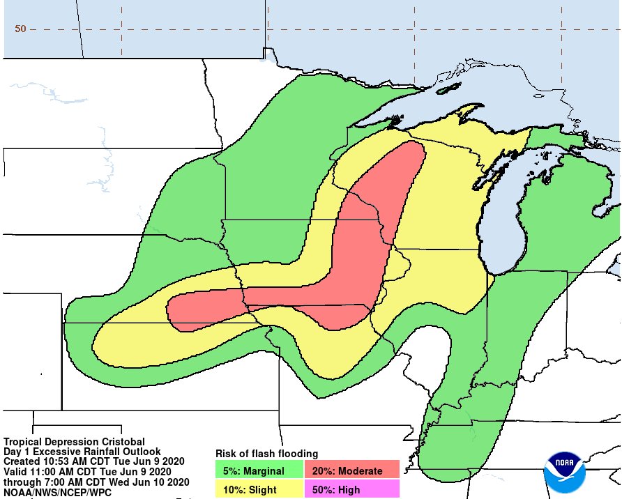 |
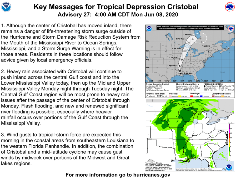
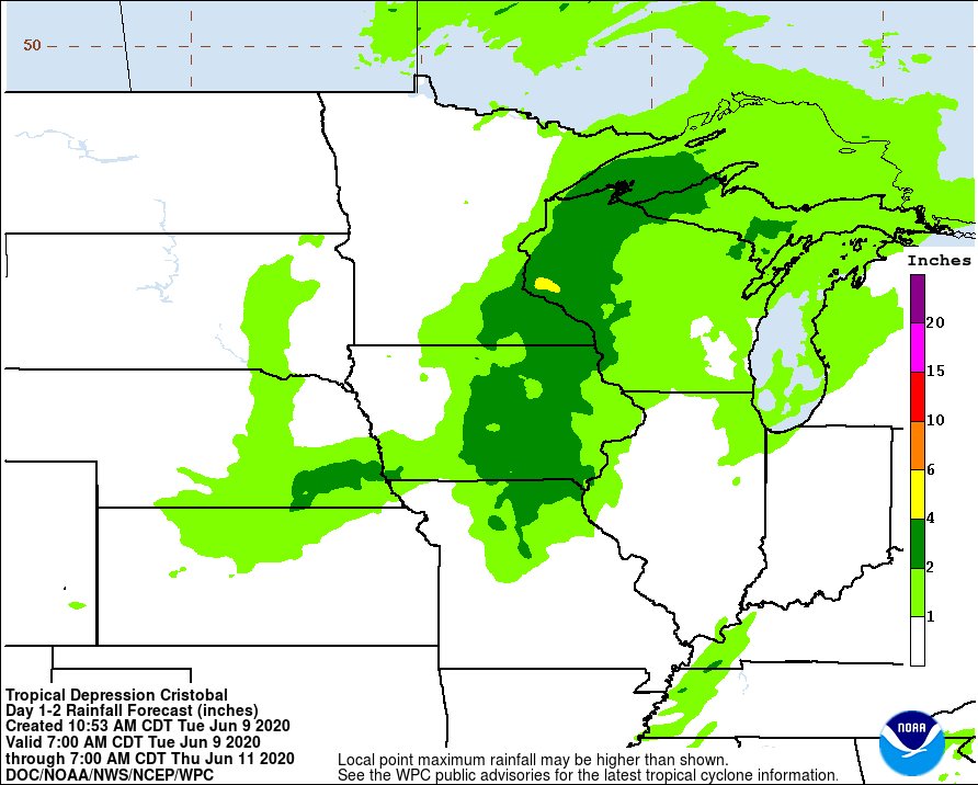
| National Hurricane Center predicted track | National Hurricane Center message as Tropical Depression Cristobal approached | Rain outlook as Tropical Depression Cristobal approached. | Flash Flood Risk forecast |
Additional Information
Other graphics
 |
 |
 |
 |
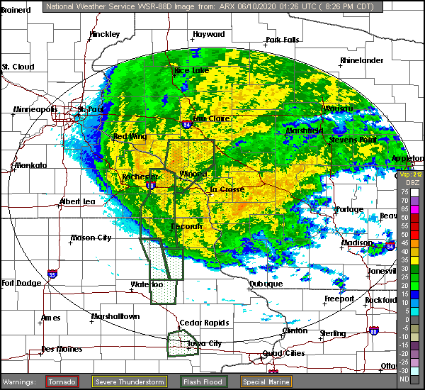
| Local radar loop showing Flash Flood Warnings | Satellite loop showing Tropical Depression Cristobal approaching | Loop showing how rainfall accumulated | Rainfall forecast for June 9 from NWS La Crosse |
 |
Media use of NWS Web News Stories is encouraged! Please acknowledge the NWS as the source of any news information accessed from this site. |
|


 Weather Story
 Weather Map
 Local Radar