Overview
|
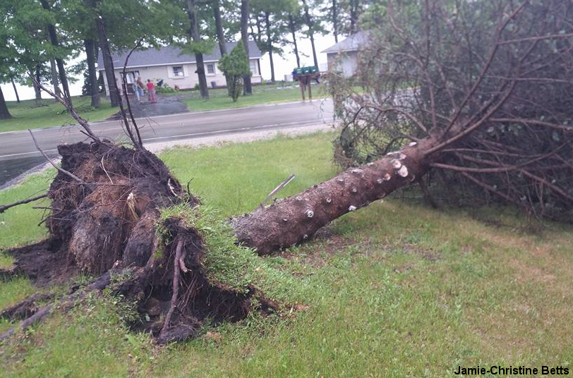
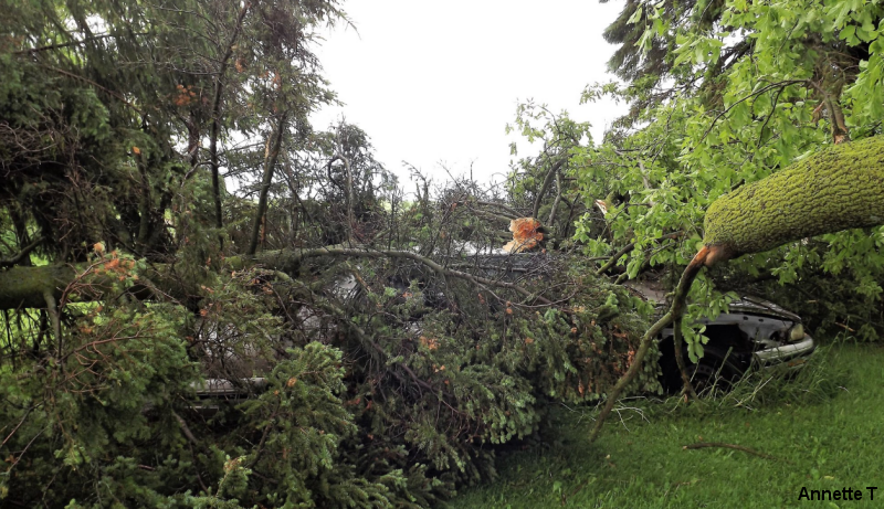
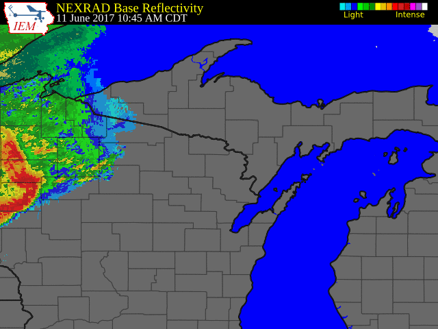
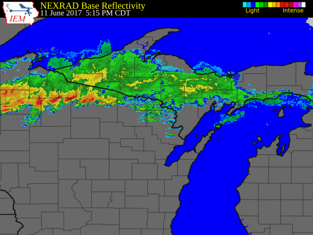
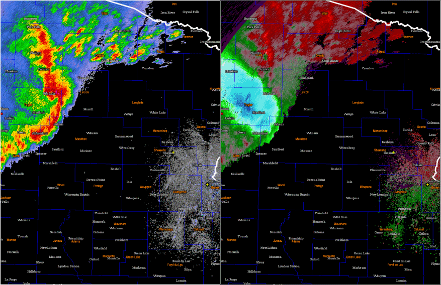
Two rounds of severe storms hit north-central and northeast Wisconsin on June 11. High winds knocked down trees and caused some isolated structural damage. The first line of severe storms formed in the Dakotas the night before and moved across Minnesota and into western Wisconsin during the morning before racing across the central and northeast part of the state during the middle of the day. The second batch of storms formed in the late afternoon across northwest Wisconsin and pushed into the north-central and far northeast part of the state. The storms were a result of very warm and humid air interacting with a stalled frontal system across the region.
|
 After the storms moved through Phillips, Wisconsin. |
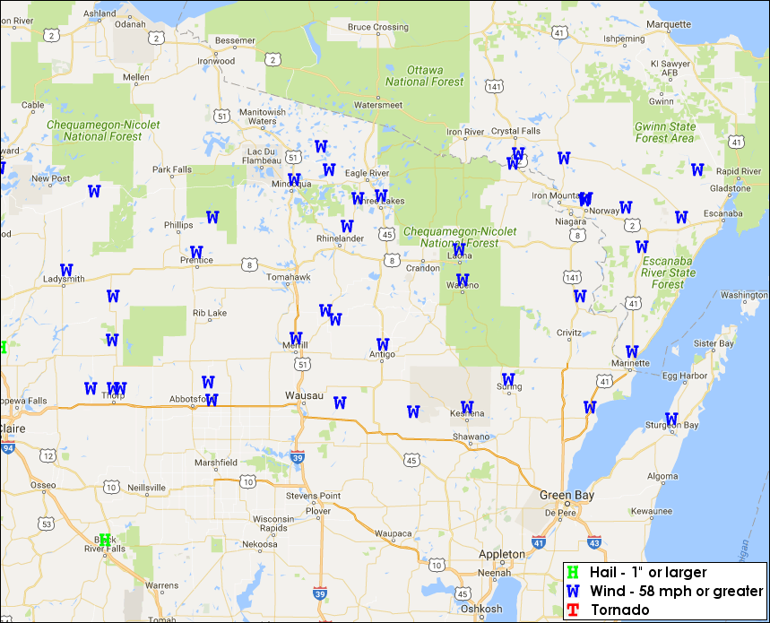
Wind & Hail:
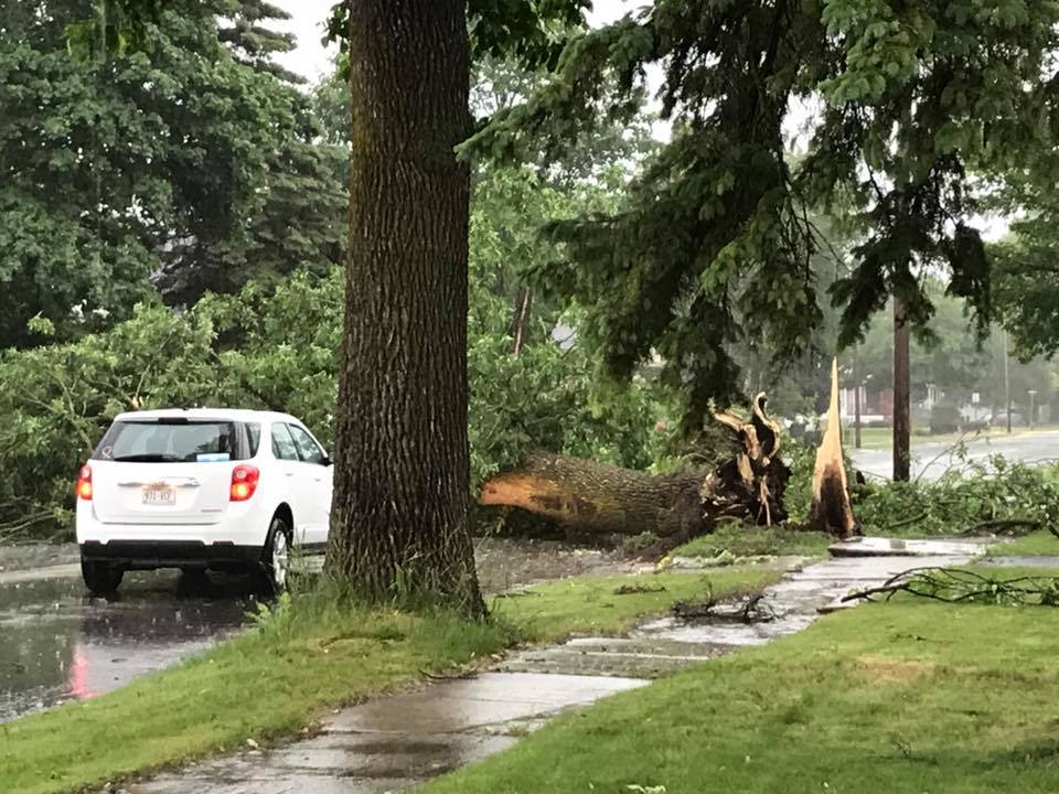
Strong thunderstorm winds knocked down trees and caused isolated structural damage. Hail was minimal, but some of the storms produced very heavy rain.
 |
 |
 |
|
| Oconto, WI | Marinette, WI | Curtiss, WI |
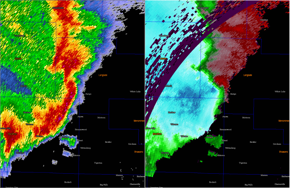
Radar:
 |
 |
 |
 |
| Round 1 Animation: Morning into Afternoon |
Round 2 Animation: Evening |
Round 1: Reflectivity and Velocity Animation | Round 1: Reflectivity and Velocity Image Close Up |
Storm Reports
Two rounds of severe weather resulted in scattered wind damage and hail across the region. Below are preliminary storm reports from our network of storm spotters, law enforcement, and the public.|
|
Round 1: Severe reports during the afternoon of June 11
..TIME...   ...EVENT...      ...CITY LOCATION...     ...LAT.LON...
..DATE...   ....MAG....      ..COUNTY LOCATION..ST.. ...SOURCE....
            ..REMARKS..

1140 AM     TSTM WND DMG     5 E COLBY               44.91N 90.20W
06/11/2017                   MARATHON           WI   TRAINED SPOTTER

            TREE BRANCHES FLYING ACROSS THE ROAD. ESTIMATED WINDS OF
            60 MPH.

1150 AM     HAIL             EDGAR                   44.91N 89.96W
06/11/2017  E0.88 INCH       MARATHON           WI   BROADCAST MEDIA

1200 PM     TSTM WND DMG     4 SE GLEASON            45.26N 89.44W
06/11/2017                   LINCOLN            WI   LAW ENFORCEMENT

            15-20 FOOT SECTION OF BARN ROOF BLOWN OFF 400-500 YARDS
            INTO THE FIELD. DEBRIS APPEARS TO BE BLOWN IN ONE
            DIRECTION. ADDITIONAL BARN DESTROYED 1/2 MILE AWAY.

1203 PM     HAIL             2 E MERRILL             45.18N 89.64W
06/11/2017  M0.88 INCH       LINCOLN            WI   AMATEUR RADIO

1210 PM     TSTM WND DMG     RINGLE                  44.90N 89.41W
06/11/2017                   MARATHON           WI   TRAINED SPOTTER

            TREES AND ROOF SHINGLES DOWN

1212 PM     TSTM WND DMG     SAYNER                  46.00N 89.53W
06/11/2017                   VILAS              WI   NWS EMPLOYEE

            FEW TREES UPROOTED. NEAR HIGHWAY 155 AND COUNTY ROAD N.
            OFF DUTY MET FROM MKE.

1212 PM     TSTM WND DMG     3 NE RHINELANDER        45.66N 89.37W
06/11/2017                   ONEIDA             WI   PUBLIC

            NEAR PINE LAKE. TREE UPROOTED. VIA SOCIAL MEDIA

1219 PM     TSTM WND DMG     MINOCQUA                45.86N 89.69W
06/11/2017                   ONEIDA             WI   TRAINED SPOTTER

            4 TO 6 INCH DIAMETER TREES DOWNED

1223 PM     TSTM WND DMG     GLEASON                 45.30N 89.50W
06/11/2017                   LINCOLN            WI   COUNTY OFFICIAL

            MULTIPLE TREES DOWN

1227 PM     TSTM WND DMG     ANTIGO                  45.15N 89.15W
06/11/2017                   LANGLADE           WI   LAW ENFORCEMENT

            TREES AND POWERLINES DOWN IN THE CITY.

1228 PM     TSTM WND GST     ANTIGO                  45.15N 89.15W
06/11/2017  M49.00 MPH       LANGLADE           WI   AWOS

1236 PM     TSTM WND DMG     SUGAR CAMP              45.78N 89.30W
06/11/2017                   ONEIDA             WI   TRAINED SPOTTER

            NUMEROUS TREES AND POWER LINES DOWN

1240 PM     TSTM WND DMG     BOWLER                  44.86N 88.96W
06/11/2017                   SHAWANO            WI   PUBLIC

            TREE LIMB SNAPPED IN BACK YARD. VIA SOCIAL MEDIA.

1245 PM     TSTM WND DMG     LAONA                   45.56N 88.68W
06/11/2017                   FOREST             WI   LAW ENFORCEMENT

            TREES AND POWER LINES DOWN ACROSS THE COUNTY. TIME
            ESTIMATED BY RADAR.

1253 PM     TSTM WND DMG     KESHENA                 44.88N 88.63W
06/11/2017                   MENOMINEE          WI   EMERGENCY MNGR

            MULTIPLE TREES AND POWERLINES DOWN ACROSS THE CITY.
            HIGHWAY 55 CLOSED DUE TO DOWNED TREES. ONE HOUSE FIRE
            LIKELY DUE TO LIGHTNING. DELAYED REPORT. TIME ESTIMATED.

0104 PM     TSTM WND DMG     1 S ST GERMAIN          45.90N 89.48W
06/11/2017                   ONEIDA             WI   AMATEUR RADIO

            18 INCH DIAMETER TREE SNAPPED 15 FEET ABOVE THE GROUND.

0106 PM     TSTM WND DMG     SURING                  45.00N 88.38W
06/11/2017                   OCONTO             WI   TRAINED SPOTTER

            NUMEROUS TREES AND POWERLINES DOWN IN THE CITY.

0120 PM     TSTM WND DMG     OCONTO                  44.88N 87.88W
06/11/2017                   OCONTO             WI   PUBLIC

            PINE TREE UPROOTED IN THE CITY. VIA SOCIAL MEDIA.

0128 PM     TSTM WND GST     CRIVITZ                 45.23N 88.01W
06/11/2017  M47.00 MPH       MARINETTE          WI   MESONET

            WBAY WEATHER NET.

0130 PM     TSTM WND DMG     OCONTO                  44.88N 87.88W
06/11/2017                   OCONTO             WI   TRAINED SPOTTER

            PICKUP TRUCK PULLING A 20 FT TRAILER WAS OVERTURNED ON US
            41 NEAR EXIT 198.

0130 PM     TSTM WND DMG     OCONTO                  44.88N 87.88W
06/11/2017                   OCONTO             WI   TRAINED SPOTTER

            SMALL TREE LIMBS DOWN. ESTIMATED 30-35 MPH GUSTS.

0134 PM     TSTM WND DMG     WAUSAUKEE               45.36N 87.94W
06/11/2017                   MARINETTE          WI   TRAINED SPOTTER

            TREES DOWN ACROSS HIGHWAY 141, PEA SIZED HAIL, MINIMAL
            VISIBILITY

0144 PM     TSTM WND GST     2 SSW MCALLISTER        45.30N 87.73W
06/11/2017  M50.00 MPH       MARINETTE          WI   TRAINED SPOTTER

            POWER OUT IN THE TOWN OF WAGNER

0151 PM     TSTM WND GST     STURGEON BAY            44.83N 87.38W
06/11/2017  M43.00 MPH       DOOR               WI   AWOS

0155 PM     TSTM WND DMG     STURGEON BAY            44.83N 87.38W
06/11/2017                   DOOR               WI   LAW ENFORCEMENT

            TREES AND POWERLINES DOWN IN THE CITIES OF STURGEON BAY,
            BAILEYS HARBOR, FISH CREEK, AND SISTER BAY. DELAYED
            REPORT. TIME ESTIMATED FOR STURGEON BAY.
Round 2: Severe reports during the evening of June 11
..TIME...   ...EVENT...      ...CITY LOCATION...     ...LAT.LON...
..DATE...   ....MAG....      ..COUNTY LOCATION..ST.. ...SOURCE....
            ..REMARKS..

0735 PM     HEAVY RAIN       EAGLE RIVER             45.91N 89.25W
06/11/2017  M1.13 INCH       VILAS              WI   TRAINED SPOTTER

            FELL IN 25 MINUTES THIS EVENING. NO HAIL.

0742 PM     TSTM WND DMG     THREE LAKES             45.79N 89.16W
06/11/2017                   ONEIDA             WI   LAW ENFORCEMENT

            TREES AND POWER LINES DOWN IN THE CITY.

0812 PM     TSTM WND DMG     5 W FLORENCE            45.93N 88.35W
06/11/2017                   FLORENCE           WI   LAW ENFORCEMENT

            TREES AND POWERLINES DOWN.

0850 PM     TSTM WND DMG     2 NW MILAN              44.99N 90.22W
06/11/2017                   MARATHON           WI   TRAINED SPOTTER

            TREES LIMBS SNAPPED.

0858 PM     TSTM WND DMG     MERRILL                 45.18N 89.68W
06/11/2017                   LINCOLN            WI   LAW ENFORCEMENT

            A FEW TREES DOWN IN CITY. ALSO MINOR STREET FLOODING.

0917 PM     FLOOD            LAC DU FLAMBEAU         45.96N 89.88W
06/11/2017                   VILAS              WI   PUBLIC

            STREET FLOODING IN CITY. SPOTTER REPORTED 6.5 INCHES OF
            RAINFALL FOR TODAY.

0922 PM     TSTM WND DMG     WABENO                  45.43N 88.66W
06/11/2017                   FOREST             WI   LAW ENFORCEMENT

            TREES DOWN NEAR COUNTY ROAD W.

0925 PM     TSTM WND GST     WABENO                  45.43N 88.66W
06/11/2017  M50.00 MPH       FOREST             WI   MESONET

            WBAY WEATHER NET.
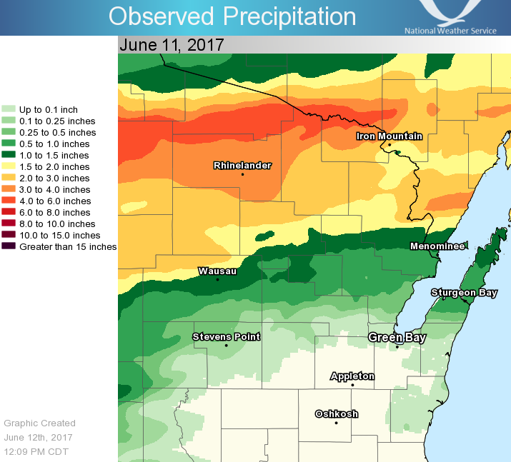
Rain Reports
Heavy rain caused some minor flooding across north-central Wisconsin.
|
|
Location                     Amount    Time/Date       Provider
Arbor Vitae-johnson Lake     5.34 in   0604 AM 06/12   UCOOP
Phelps                       4.71 in   0700 AM 06/12   COOP
Phelps 2 SW                  4.14 in   1002 AM 06/12   RAWS
Tomahawk 3 W                 3.91 in   1010 AM 06/12   RAWS
Rice Reservor - Tomahawk     3.88 in   0700 AM 06/12   COOP
Alvin-3nw                    3.70 in   0700 AM 06/12   UCOOP
Eagle River - South          3.67 in   0659 AM 06/12   UCOOP
Saint Germain 3 WNW          3.66 in   0700 AM 06/12   COCORAHS
Summit Lake                  3.66 in   0600 AM 06/12   COOP
Spirit Dam                   3.61 in   0800 AM 06/12   UCOOP
Reservoir                    3.53 in   0700 AM 06/12   COOP
3 SSE Mc Naughton            3.38 in   0600 AM 06/12   COCORAHS
Eagle River 4 E              3.35 in   0542 AM 06/12   UCOOP
Eagle River 1 WNW            3.35 in   0800 AM 06/12   COCORAHS
Rhinelander Airport          3.26 in   0653 AM 06/12   ASOS
Spread Eagle 1 NW            3.25 in   0700 AM 06/12   COCORAHS
Commonwealth                 3.23 in   0545 AM 06/12   COCORAHS
Rhinelander                  3.18 in   0530 AM 06/12   COOP
Arbor Vitae - Woodruff 2 S   2.99 in   1010 AM 06/12   RAWS
Crandon                      2.93 in   0600 AM 06/12   UCOOP
Argonne 1.5 NW               2.93 in   0653 AM 06/12   COOP
Lake Tomahawk 2 SE           2.91 in   0600 AM 06/12   UCOOP
Merrill 7 W                  2.68 in   0600 AM 06/12   COCORAHS
Wabeno 2 NNW                 2.62 in   1001 AM 06/12   RAWS
Lac Vieux Desert             2.40 in   0900 AM 06/12   COOP
Merrill                      2.40 in   0800 AM 06/12   COOP
Wausaukee                    2.07 in   0800 AM 06/12   COOP
Wausaukee 2 NW               2.05 in   1005 AM 06/12   RAWS
Ephraim-5se-north Bay        1.92 in   0630 AM 06/12   UCOOP
Amberg 9 E                   1.89 in   0648 AM 06/12   UCOOP
Lakewood 2 ENE               1.82 in   1001 AM 06/12   CWOP
Fish Creek 3s - Juddville    1.71 in   0800 AM 06/12   UCOOP
Aurora                       1.68 in   0652 AM 06/12   UCOOP
Antigo 1 SSW                 1.68 in   0800 AM 06/12   COOP
Rest Lake                    1.57 in   0830 AM 06/12   COOP
Fish Creek 1 E Wwtp          1.53 in   0719 AM 06/12   UCOOP
Antigo Airport               1.45 in   0655 AM 06/12   AWOS
Washington Island            1.44 in   0530 AM 06/12   COOP
Wausau Airport               1.43 in   0654 AM 06/12   ASOS
Antigo 2 ENE                 1.38 in   1005 AM 06/12   RAWS
Manitowish Waters Airport    1.34 in   0655 AM 06/12   AWOS
Weston 1 NE                  1.30 in   0700 AM 06/12   COCORAHS
Fish Creek                   1.24 in   0700 AM 06/12   COCORAHS
Ephraim 1 Ne - Wwtp          1.22 in   0910 AM 06/12   COOP
Wausau 1 ESE                 1.21 in   1021 AM 06/12   CWOP
Land O Lakes 3 W             1.20 in   0835 AM 06/12   COCORAHS
Rothschild                   1.13 in   0700 AM 06/12   COCORAHS
Sister Bay 1 N               1.13 in   0630 AM 06/12   COCORAHS
Boulder Junction 9 ENE       1.10 in   0725 AM 06/12   COCORAHS
White Lake 1 SE              1.08 in   0800 AM 06/12   COOP
Mountain 2 ESE               1.05 in   1043 AM 06/12   CWOP
Egg Harbor - Wwtp            1.05 in   0700 AM 06/12   UCOOP

Observations are collected from a variety of sources with varying
equipment and exposures. We thank all volunteer weather observers
for their dedication. Not all data listed are considered official.
 |
Media use of NWS Web News Stories is encouraged! Please acknowledge the NWS as the source of any news information accessed from this site. |
|