Overview
|
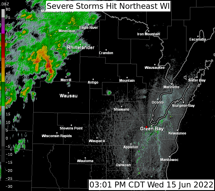
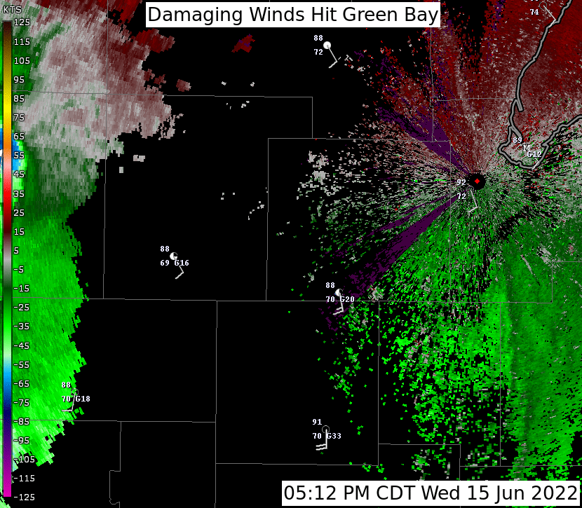
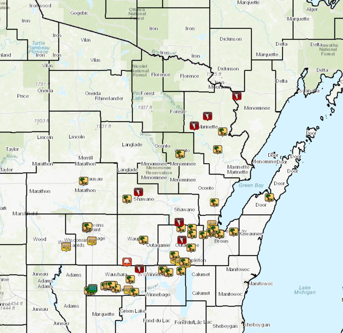
On June 15, 2022, a cold front moved across northeast Wisconsin and generated widespread severe weather. Thunderstorms developed during the early afternoon hours over southeast Minnesota and northeast Iowa before intensifying over southwest Wisconsin. The strong strong to severe storms moved into north-central Wisconsin between 3 and 4 pm and raced northeast with an impressive forward speed of 40 to 75 mph. Thunderstorm wind damage was reported across Langlade, Marathon, Portage, and Waushara counties as the storms moved through. The storms gradually congealed into broken line segments over northeast Wisconsin. Downed trees and powerlines were reported from Crivitz to Neenah from these clusters of storms. The storms knocked out power for over 60,000 customers across central and northeast Wisconsin. NWS Green Bay conducted storm damage surveys across portions of east-central and northeast Wisconsin. We analyzed a total of 10 tornadoes, nine of which were EF-1, and one EF-2.
Please click on the tabs below for more information. |
.gif) |
A Favorable Environment for Severe Thunderstorms
|
The 4 pm surface analysis from the Weather Prediction Center (WPC) (on the right) showed a wave of low pressure moving northeast along a cold front across central Wisconsin. A warm front was positioned over the Upper Peninsula to northern Lake Michigan, which placed northeast Wisconsin in the warm sector ahead of the storm system. Strong convergence along the cold front and ahead of the surface low helped to create strong updrafts that led to severe thunderstorms across northeast Wisconsin. |
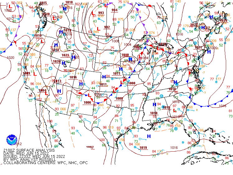 WPC Surface Analysis June 15 at 4 pm |
|
Goes 16 GeoColor Imagery overlayed with Group Energy Density from 2 pm to 10 pm on June 15th is shown on the right. Overcast conditions prevailed across the northwest half of Wisconsin through early afternoon before widespread thunderstorms developed. Some storms developed across north-central Wisconsin during the morning, but were not severe in nature. However, the mostly clear skies across the eastern half of Wisconsin promoted strong instability to develop with the heat of the day and helped maintain thunderstorm intensity into the evening hours. |
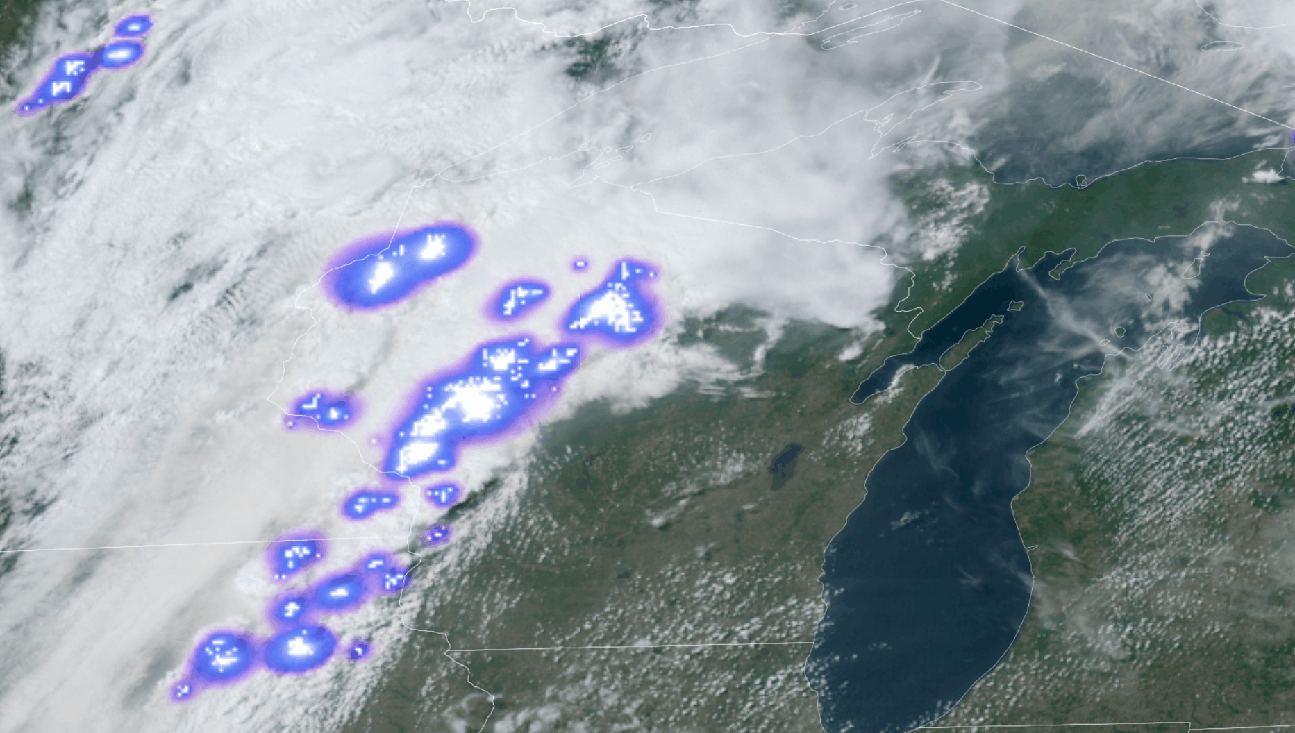 Goes 16 GeoColor Imagery overlayed with Group Energy Density June 15 2 pm to 10 pm |
|
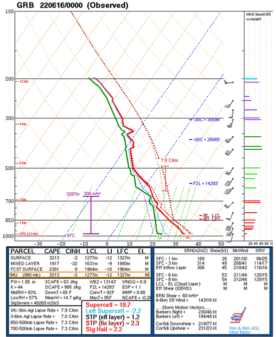
The 00Z KGRB sounding during the evening of June 15th was released about 1/2 hour prior to the severe thunderstorms approaching the office, and is shown on the right. It showed a thermal and wind profile favorable for severe weather. Instability was plentiful with mixed layer CAPE at 1817 J/kg. Winds aloft in the 1 to 3 km layer were also quite strong between 40 to 60 kts, which is about 2 standard deviations above the climatological average. The change of wind speed and wind direction in the lowest 3 km of the atmosphere provided favorable conditions for tornadic development as well as straight line wind damage. Moisture was also plentiful ahead of the storms as Green Bay measured a surface dewpoint of 72 degrees and precipitable water values were measured at 1.95 inches, which was the highest on record for the date and time going back to to the year 1953.
|
|
|
|
|
Tornado / Radar Information:
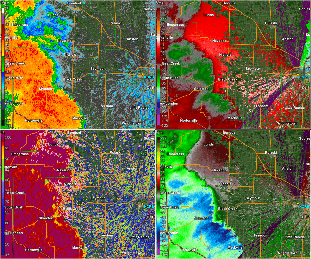
Note: Due to velocity folding/dealiasing issues, wind measurements displayed on radar (speed and direction) may not always be accurate. Use radar data with caution.
Tornado Listing / Information & Radar:
|
Seymour / Black Creek -
Track Map 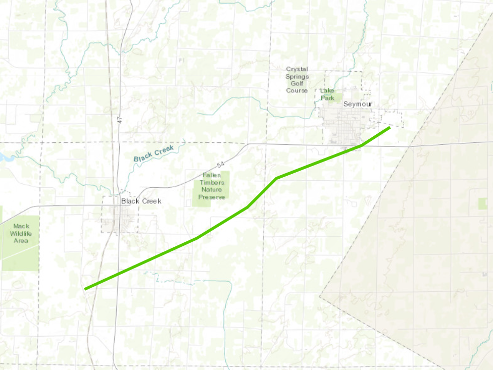 
|
||||||||||||||||||||||
|
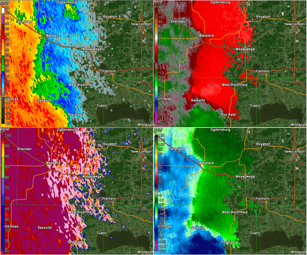
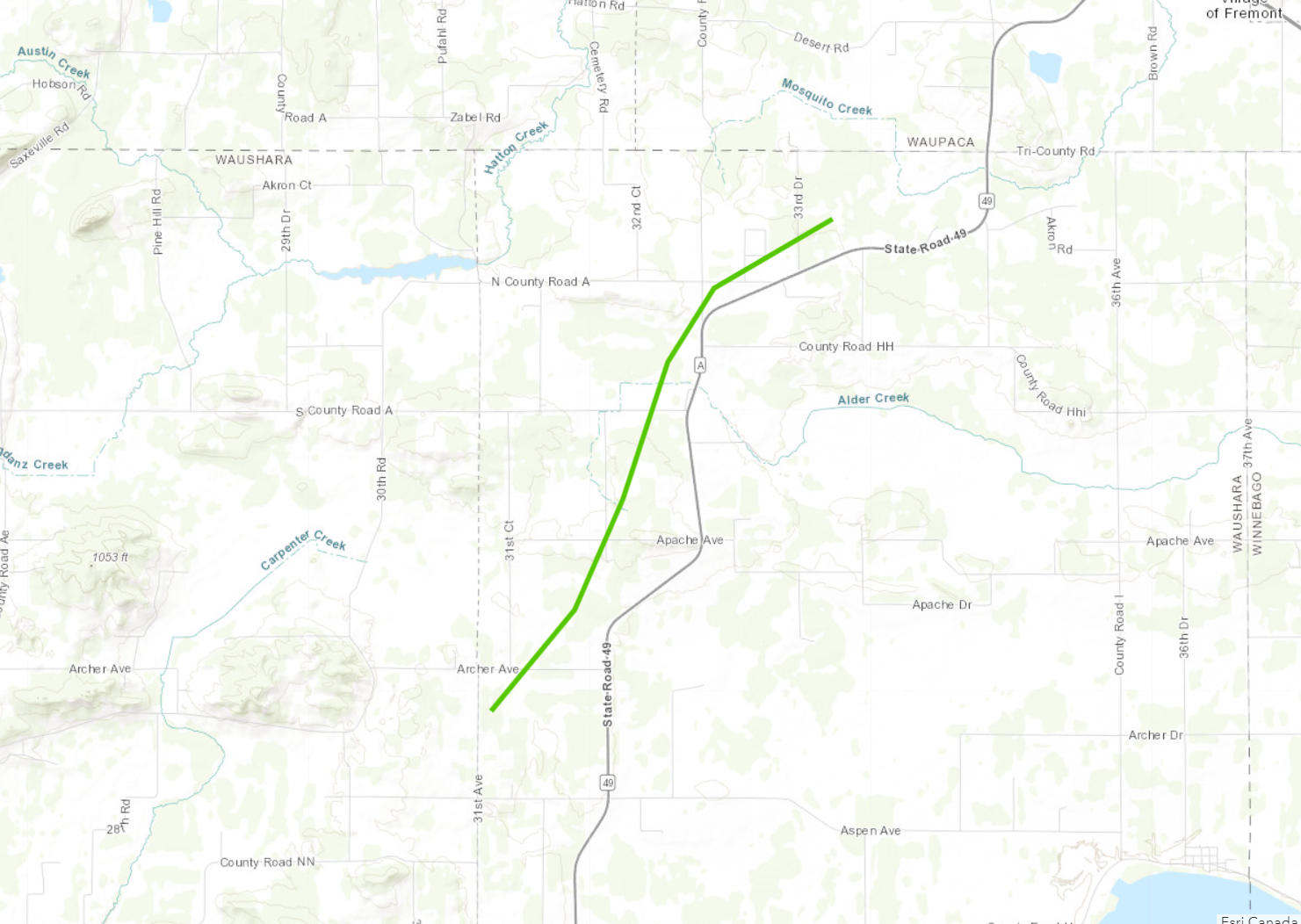
West Bloomfield - Waushara County
Track Map
|
||||||||||||||||||||||
|
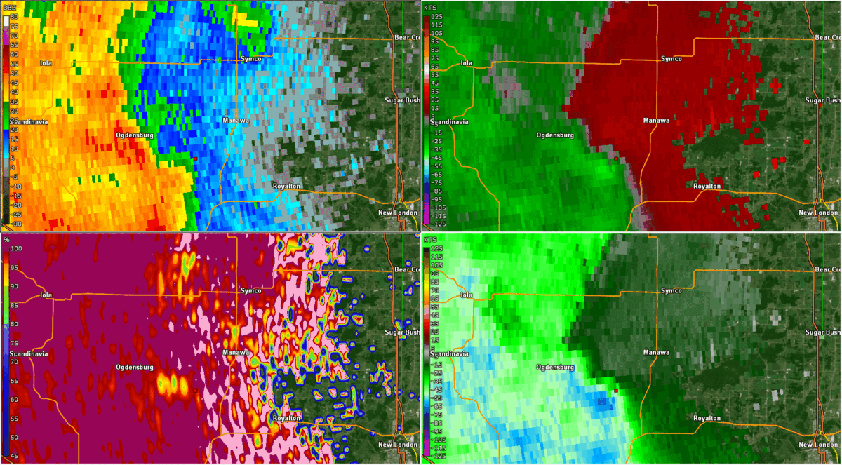
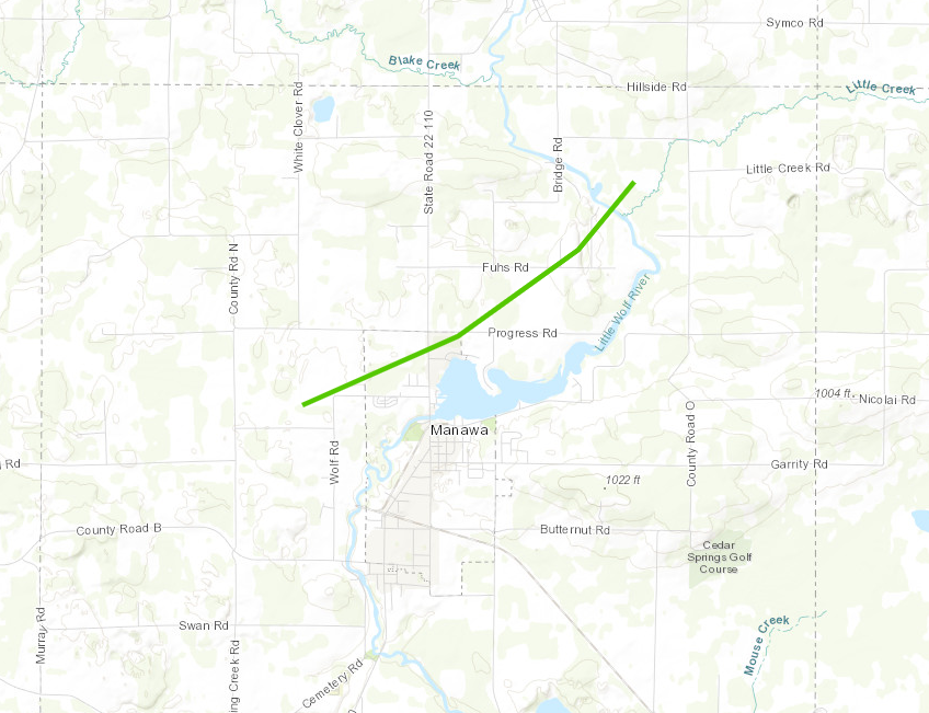
Manawa - Waupaca County
Track Map
|
||||||||||||||||||||||
|
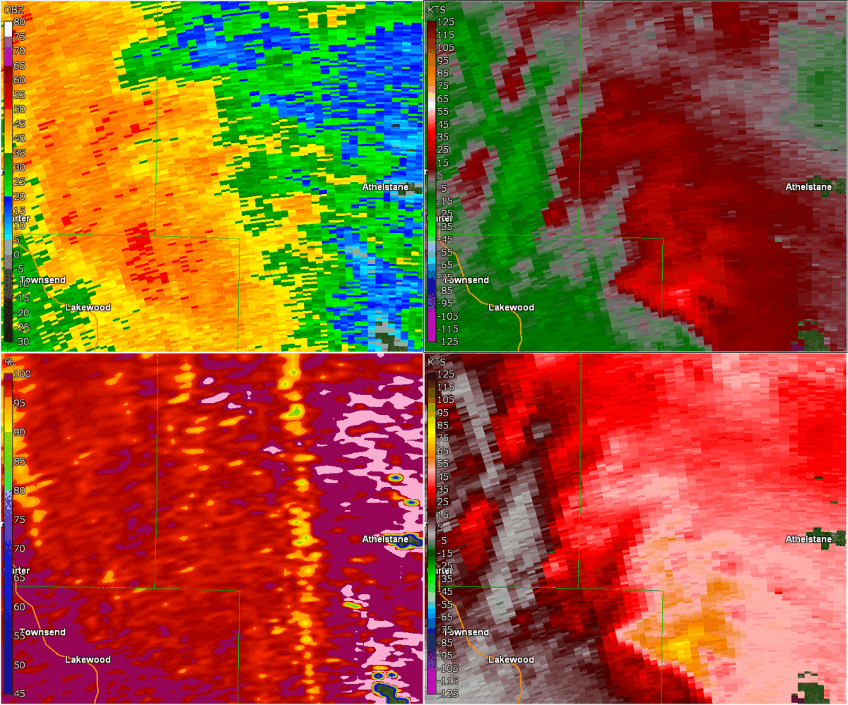
Silver Cliff - Marinette County
Track Map 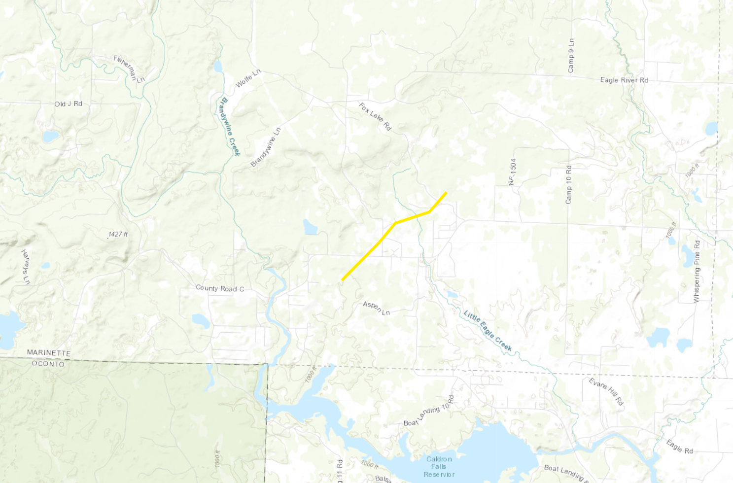
|
||||||||||||||||||||||
|
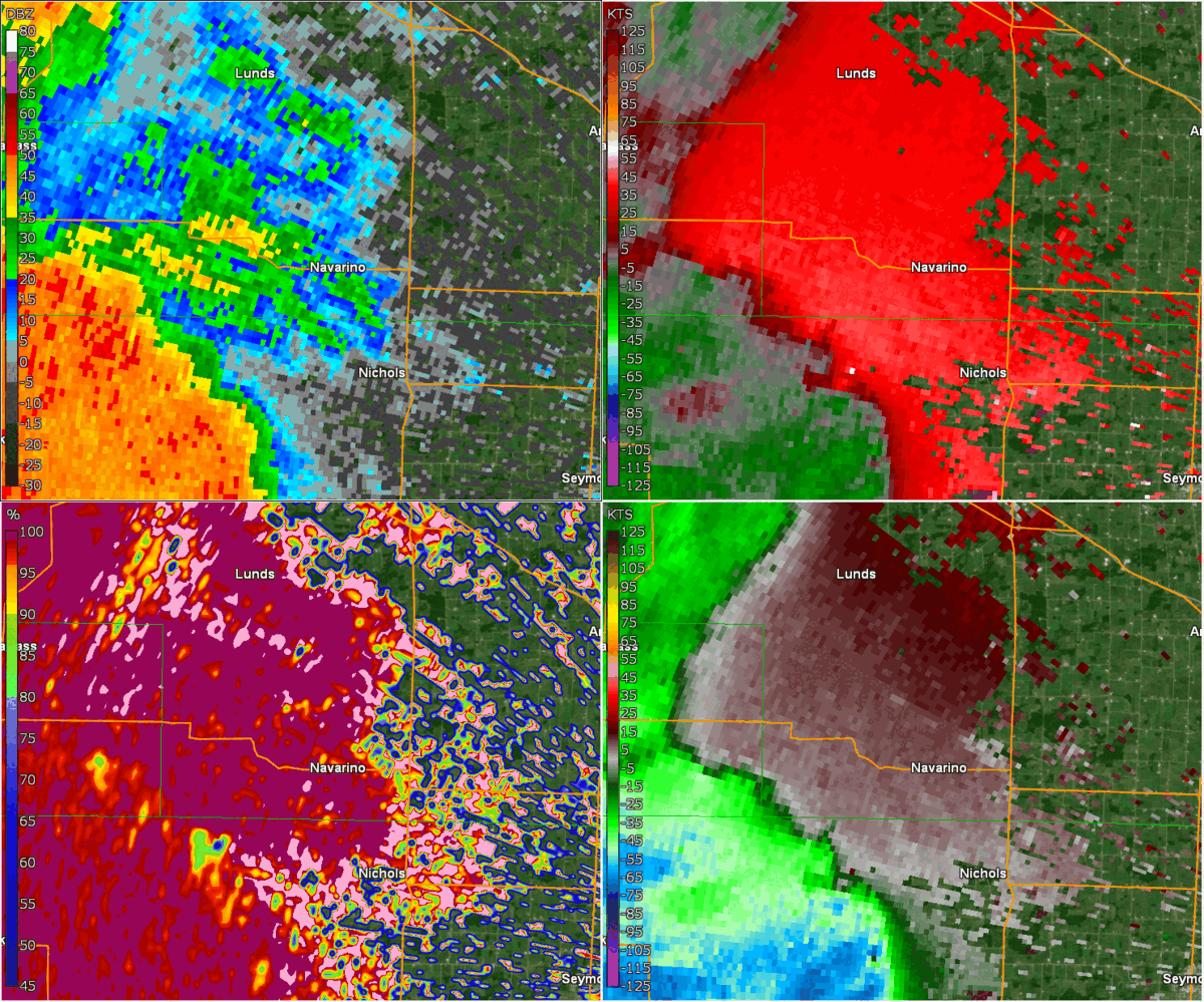
Navarino - Shawano County
Track Map 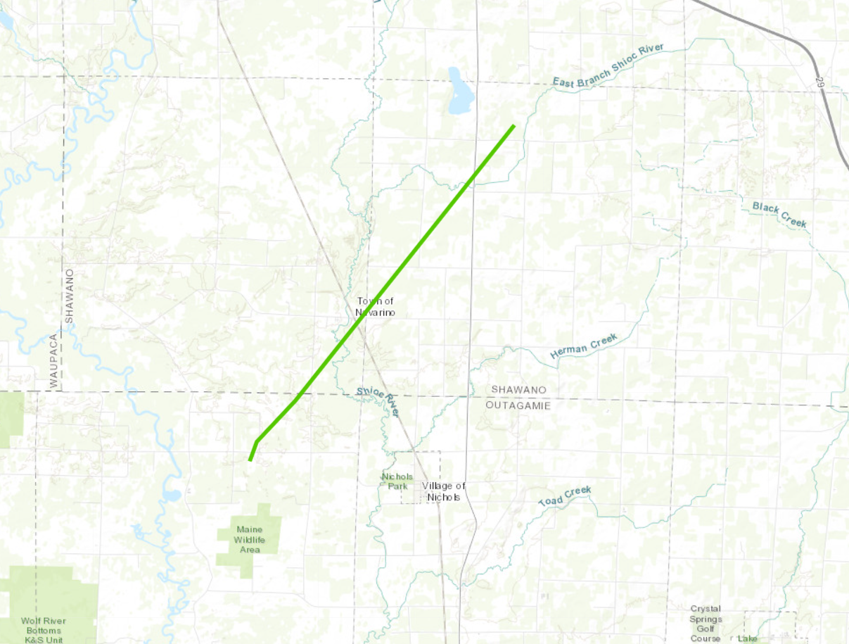
|
||||||||||||||||||||||
|
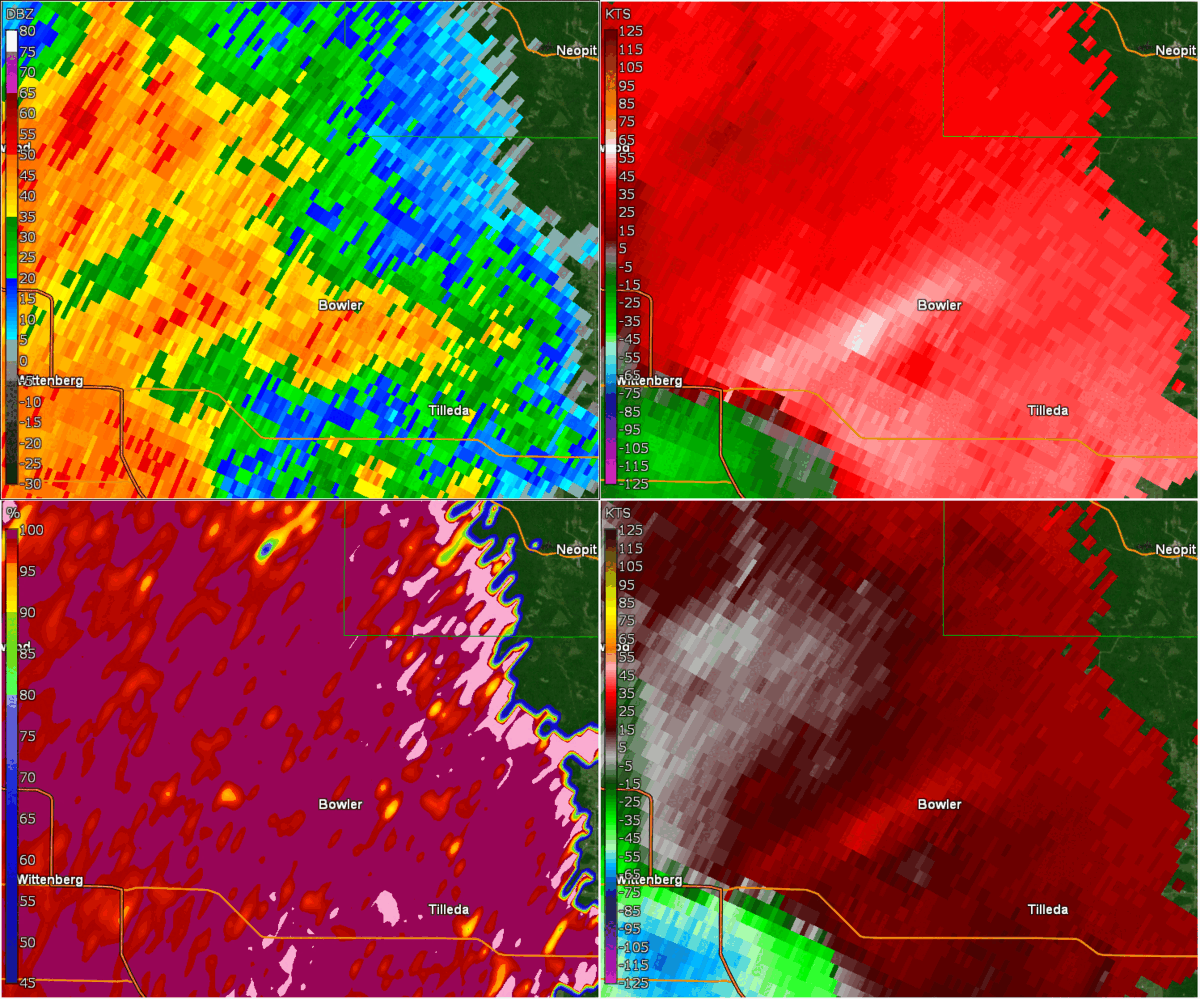
Bowler - Shawano County
Track Map 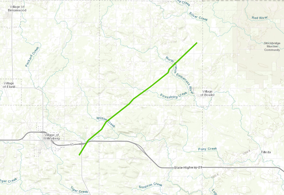
|
||||||||||||||||||||||
|
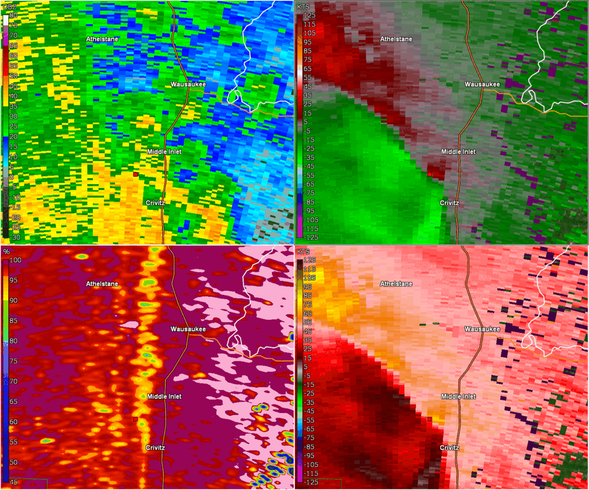
Middle Inlet - Marinette County
Track Map .PNG)
|
||||||||||||||||||||||
|
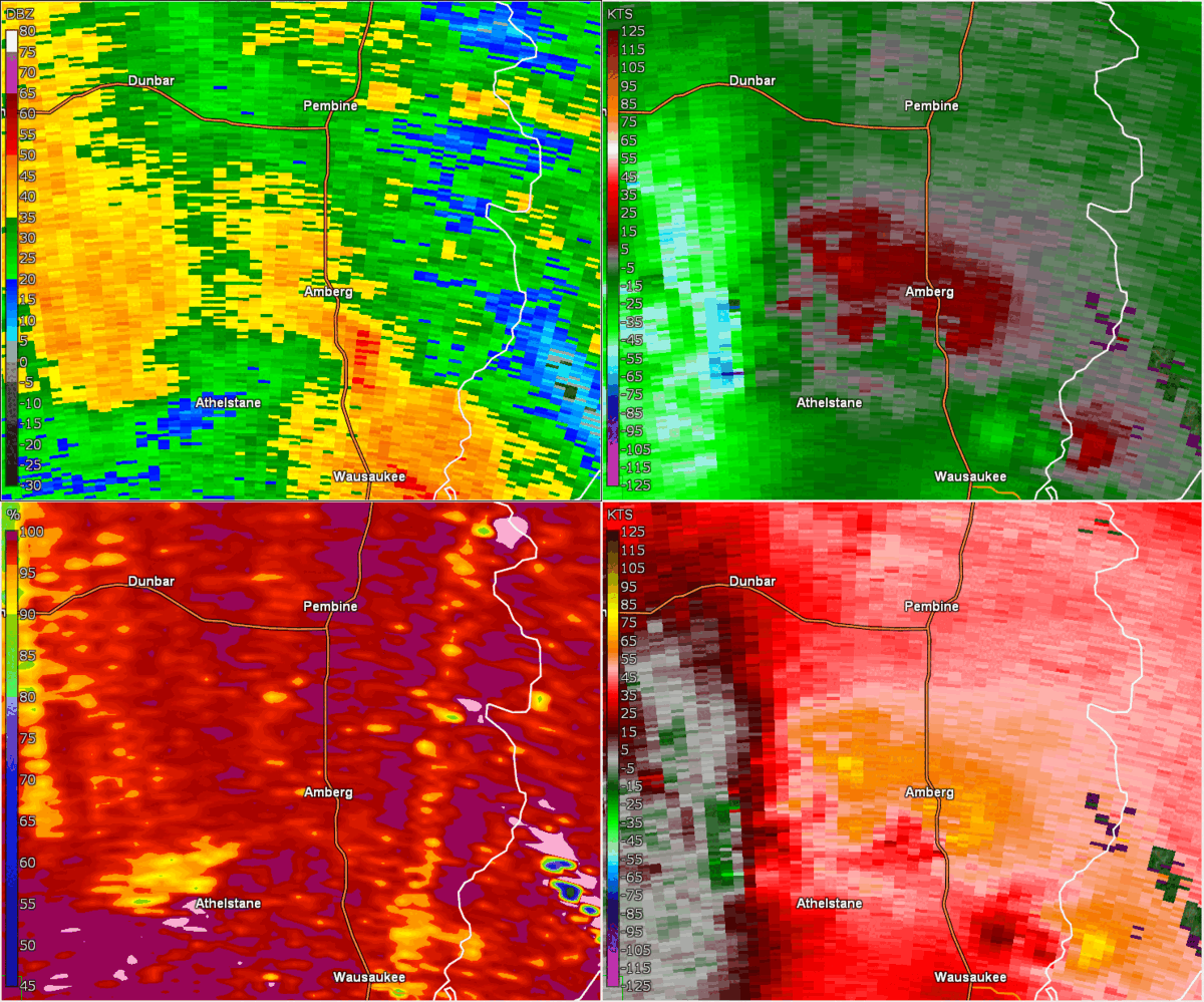
Amberg - Marinette County
Track Map 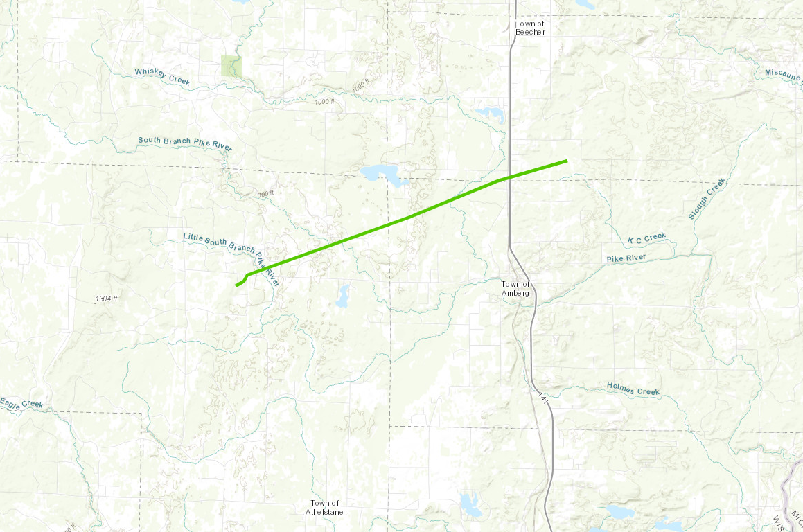
|
||||||||||||||||||||||
|
Pembine - Marinette County
Track Map 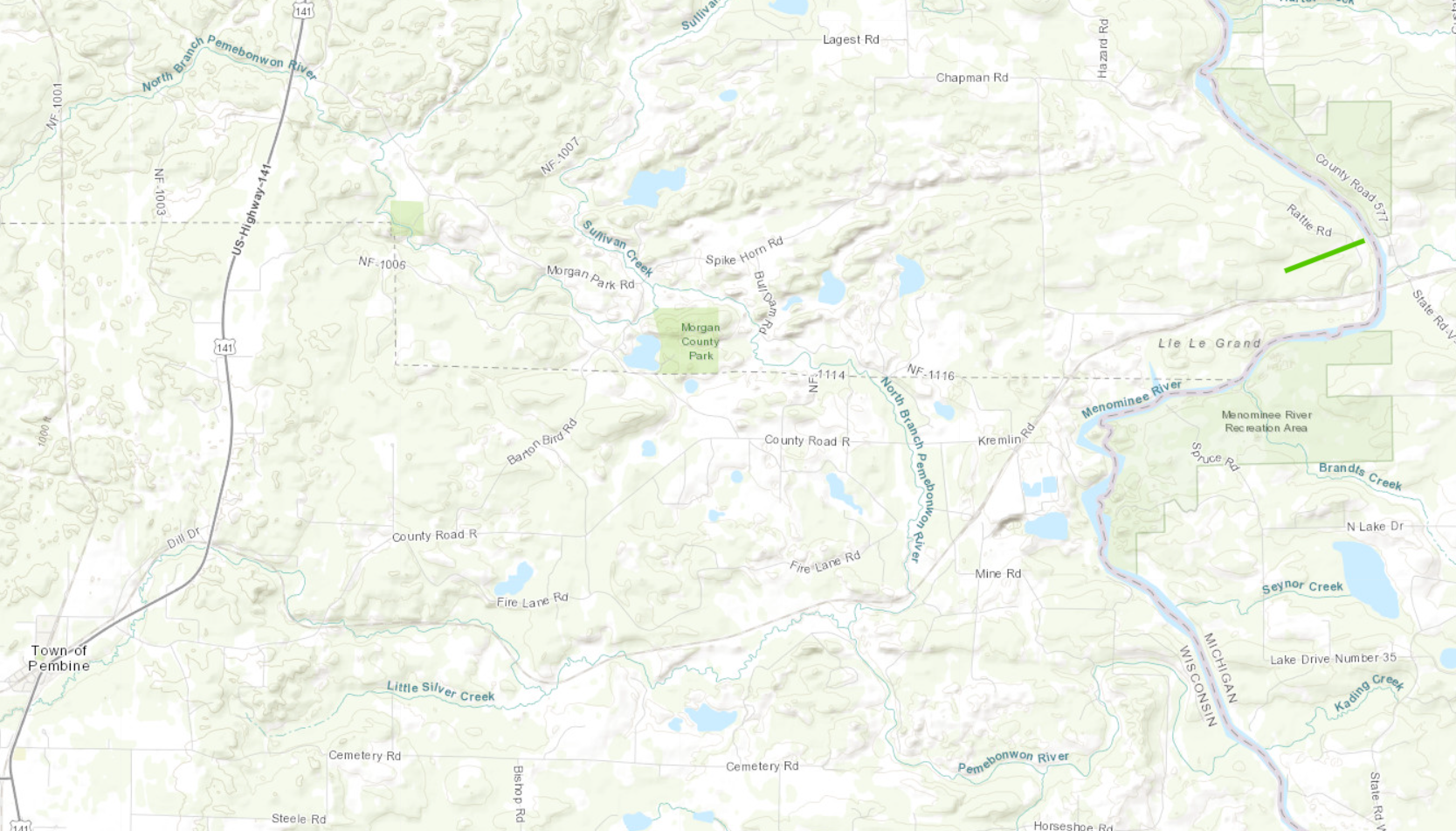
|
||||||||||||||||||||||
|
Stockbridge-Munsee - Shawano County
Track Map 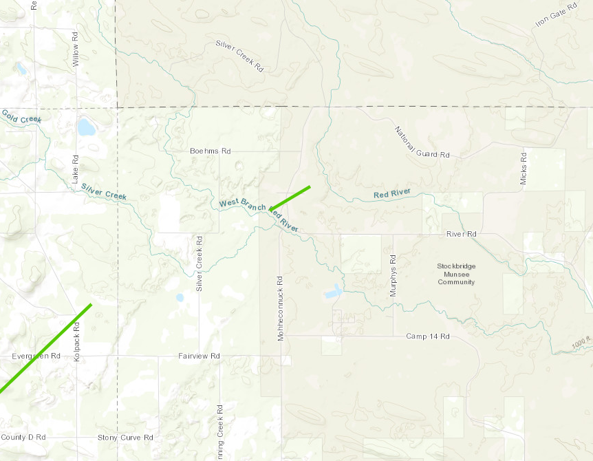
|
||||||||||||||||||||||
| EF0 Weak 65-85 mph |
EF1 Moderate 86-110 mph |
EF2 Significant 111-135 mph |
EF3 Severe 136-165 mph |
EF4 Extreme 166-200 mph |
EF5 Catastrophic 200+ mph |
 |
|||||
Storm Reports:
 |
|
| Storm reports on June 15, 2022 Map will be updated once tornadoes are confirmed |
PRELIMINARY LOCAL STORM REPORT...SUMMARY
NATIONAL WEATHER SERVICE GREEN BAY WI
LAST UPDATED: 1027 PM CDT FRI JUL 8 2022
..TIME... ...EVENT... ...CITY LOCATION... ...LAT.LON...
..DATE... ....MAG.... ..COUNTY LOCATION..ST.. ...SOURCE....
..REMARKS..
0454 PM TSTM WND GST WISCONSIN RAPIDS 44.40N 89.84W
06/15/2022 M53 MPH WOOD WI ASOS
0457 PM TSTM WND DMG WAUSAU 44.96N 89.63W
06/15/2022 MARATHON WI TRAINED SPOTTER
TREES DOWN IN THE CITY OF WAUSAU.
0502 PM TSTM WND DMG 5 NNW STEVENS POINT 44.57N 89.58W
06/15/2022 PORTAGE WI PUBLIC
CORRECTS PREVIOUS TSTM WND DMG REPORT FROM 5
NNW STEVENS POINT. TREES DOWN.
0504 PM TSTM WND DMG 4 NNW STEVENS POINT 44.56N 89.59W
06/15/2022 PORTAGE WI PUBLIC
CORRECTS PREVIOUS TSTM WND DMG REPORT FROM 4
NNW STEVENS POINT. REPORT FROM MPING: 3-INCH
TREE LIMBS BROKEN; POWER POLES BROKEN.
0509 PM TSTM WND GST PLOVER 44.45N 89.53W
06/15/2022 M51 MPH PORTAGE WI CO-OP OBSERVER
0522 PM TSTM WND DMG 2 WSW COLOMA 44.02N 89.54W
06/15/2022 WAUSHARA WI PUBLIC
TREES AND POWERLINES DOWN.
0525 PM TSTM WND DMG 3 W COLOMA 44.02N 89.57W
06/15/2022 WAUSHARA WI PUBLIC
TREE LIMBS DOWN.
0528 PM FLASH FLOOD 1 NW COLOMA 44.04N 89.52W
06/15/2022 WAUSHARA WI PUBLIC
REPORT FROM MPING: STREET/ROAD FLOODING;
STREET/ROAD CLOSED; VEHICLES STRANDED.
0528 PM TSTM WND GST WAUTOMA 44.06N 89.28W
06/15/2022 M66 MPH WAUSHARA WI AWOS
CORRECTS PREVIOUS TSTM WND GST REPORT FROM
WAUTOMA.
0530 PM TSTM WND DMG 1 N WAUTOMA 44.07N 89.28W
06/15/2022 WAUSHARA WI PUBLIC
TREES DOWN. SHINGLES BLOWN OFF HOUSES.
0532 PM TSTM WND DMG 1 WNW SILVER LAKE 44.04N 89.24W
06/15/2022 WAUSHARA WI PUBLIC
TREES UPROOTED OR SNAPPED. A ROOF BLOWN OFF.
0537 PM TSTM WND DMG 4 W WAUTOMA 44.06N 89.37W
06/15/2022 WAUSHARA WI PUBLIC
REPORT FROM MPING: 1-INCH TREE LIMBS BROKEN;
SHINGLES BLOWN OFF.
0539 PM TSTM WND DMG 3 WNW WAUTOMA 44.07N 89.34W
06/15/2022 WAUSHARA WI PUBLIC
TREE AND POWER LINES DOWN.
0539 PM TSTM WND GST REDGRANITE 44.03N 89.09W
06/15/2022 E70 MPH WAUSHARA WI TRAINED SPOTTER
0540 PM TSTM WND DMG 2 WNW WAUTOMA 44.07N 89.32W
06/15/2022 WAUSHARA WI PUBLIC
TREES AND POWER LINES DOWN.
0541 PM TSTM WND DMG 2 SSW AURORAVILLE 44.01N 89.02W
06/15/2022 WAUSHARA WI PUBLIC
TREE LIMBS DOWN.
0541 PM TSTM WND DMG 1 W WAUTOMA 44.07N 89.30W
06/15/2022 WAUSHARA WI PUBLIC
REPORT FROM MPING: 3-INCH TREE LIMBS BROKEN;
POWER POLES BROKEN.
0541 PM TSTM WND DMG 1 W WAUTOMA 44.07N 89.30W
06/15/2022 WAUSHARA WI PUBLIC
REPORT FROM MPING: 3-INCH TREE LIMBS BROKEN;
POWER POLES BROKEN.
0542 PM TSTM WND DMG 2 E WITTENBERG 44.81N 89.11W
06/15/2022 SHAWANO WI TRAINED SPOTTER
TREES DOWN ALONG HIGHWAY 29.
0543 PM TORNADO WEST BLOOMFIELD 44.21N 88.96W
06/15/2022 WAUSHARA WI NWS STORM SURVEY
EF1 TORNADO. NO INJURIES OR FATALITIES. TIME
ESTIMATED OFF RADAR. MORE DETAILS TO FOLLOW.
0544 PM TSTM WND DMG 3 ENE BOWLER 44.87N 88.91W
06/15/2022 SHAWANO WI EMERGENCY MNGR
TREES UPROOTED AND FALLEN ONTO HOUSE. NWS
DAMAGE SURVEY ESTIMATED 90 MPH WINDS.
DELAYED REPORT.
0544 PM TSTM WND DMG 2 SSE PINE RIVER 44.12N 89.07W
06/15/2022 WAUSHARA WI PUBLIC
REPORT FROM MPING: 1-INCH TREE LIMBS BROKEN;
SHINGLES BLOWN OFF.
0545 PM TORNADO 1 NW BOWLER 44.87N 88.97W
06/15/2022 SHAWANO WI NWS STORM SURVEY
DELAYED REPORT. SURVEY TEAM CONFIRMED AN EF1
TORNADO NEAR BOWLER WISCONSIN. WIND SPEEDS
WERE ESTIMATED AT 104 MPH. TIME ESTIMATED
VIA RADAR. MORE DETAILS TO FOLLOW.
0545 PM TSTM WND DMG 5 NE BOWLER 44.92N 88.90W
06/15/2022 SHAWANO WI EMERGENCY MNGR
WIDESPREAD (HARDWOOD) TREES UPROOTED. NWS
DAMAGE SURVEY ESTIMATED SPEEDS OF 94 MPH.
DELAYED REPORT.
0545 PM TSTM WND DMG 3 NNE BOWLER 44.90N 88.93W
06/15/2022 SHAWANO WI EMERGENCY MNGR
TREE UPROOTED ONTO CAR. NWS DAMAGE SURVEY
ESTIMATED 85 MPH WINDS. DELAYED REPORT.
0545 PM TSTM WND DMG 5 NNE BOWLER 44.92N 88.91W
06/15/2022 SHAWANO WI EMERGENCY MNGR
WIDESPREAD TREES FLATTENED AND TRUNKS
SNAPPED. NWS DAMAGE SURVEY ESTIMATED 95 MPH
WINDS. DELAYED REPORT.
0545 PM TSTM WND DMG 5 NNE BOWLER 44.92N 88.92W
06/15/2022 SHAWANO WI EMERGENCY MNGR
WIDESPREAD (HARDWOOD) TREES UPROOTED, WITH
SOME TRUNKS SNAPPED ON SMALLER DIAMETER
TREES. NWS DAMAGE SURVEY ESTIMATED WIND
SPEEDS OF 94 MPH. DELAYED REPORT.
0545 PM TSTM WND DMG 4 NE BOWLER 44.91N 88.91W
06/15/2022 SHAWANO WI EMERGENCY MNGR
TREE UPROOTED. NWS DAMAGE SURVEY ESTIMATED
90 MPH WINDS. DELAYED REPORT.
0547 PM TSTM WND DMG 3 E WEST BLOOMFIELD 44.21N 88.91W
06/15/2022 WAUSHARA WI NWS STORM SURVEY
NWS DAMAGE SURVEY FOUND SHINGLES OFF BARN
ROOF. ESTIMATED 75 MPH WINDS. DELAYED
REPORT.
0547 PM TSTM WND DMG 5 SW NEOPIT 44.94N 88.90W
06/15/2022 SHAWANO WI EMERGENCY MNGR
WIDESPREAD TREES FLATTENED. NWS DAMAGE
SURVEY ESTIMATED 94 MPH WINDS. DELAYED
REPORT.
0549 PM TSTM WND DMG 1 W FREMONT 44.26N 88.88W
06/15/2022 WAUPACA WI NWS STORM SURVEY
NWS STORM SURVEY FOUND ROOFING PEELED
UPWARDS ACROSS METAL STORAGE SYSTEM.
ESTIMATED 79 MPH WINDS. DELAYED REPORT.
0553 PM FUNNEL CLOUD 3 SE RURAL 44.27N 89.11W
06/15/2022 WAUPACA WI PUBLIC
0556 PM TSTM WND DMG MANAWA 44.46N 88.91W
06/15/2022 WAUPACA WI TRAINED SPOTTER
CORRECTS PREVIOUS TSTM WND DMG REPORT FROM
MANAWA. TREES DOWN.
0559 PM TSTM WND DMG LARSEN 44.18N 88.61W
06/15/2022 WINNEBAGO WI TRAINED SPOTTER
TREES DOWN.
0559 PM TSTM WND DMG 1 W WINCHESTER 44.20N 88.68W
06/15/2022 WINNEBAGO WI PUBLIC
REPORT FROM MPING: TREES UPROOTED OR
SNAPPED; ROOF BLOWN OFF.
0604 PM TSTM WND GST GREENVILLE 44.29N 88.53W
06/15/2022 E55 MPH OUTAGAMIE WI TRAINED SPOTTER
0605 PM TSTM WND DMG 3 SE STEPHENSVILLE 44.33N 88.54W
06/15/2022 OUTAGAMIE WI PUBLIC
TREES DOWN.
0607 PM TSTM WND DMG 4 NNW STEVENS POINT 44.57N 89.59W
06/15/2022 PORTAGE WI PUBLIC
TREE LIMBS BROKEN.
0608 PM TSTM WND DMG 5 NNW STEVENS POINT 44.57N 89.58W
06/15/2022 PORTAGE WI PUBLIC
TREES DOWN.
0609 PM TSTM WND GST 4 WNW APPLETON 44.27N 88.47W
06/15/2022 M72 MPH OUTAGAMIE WI MESONET
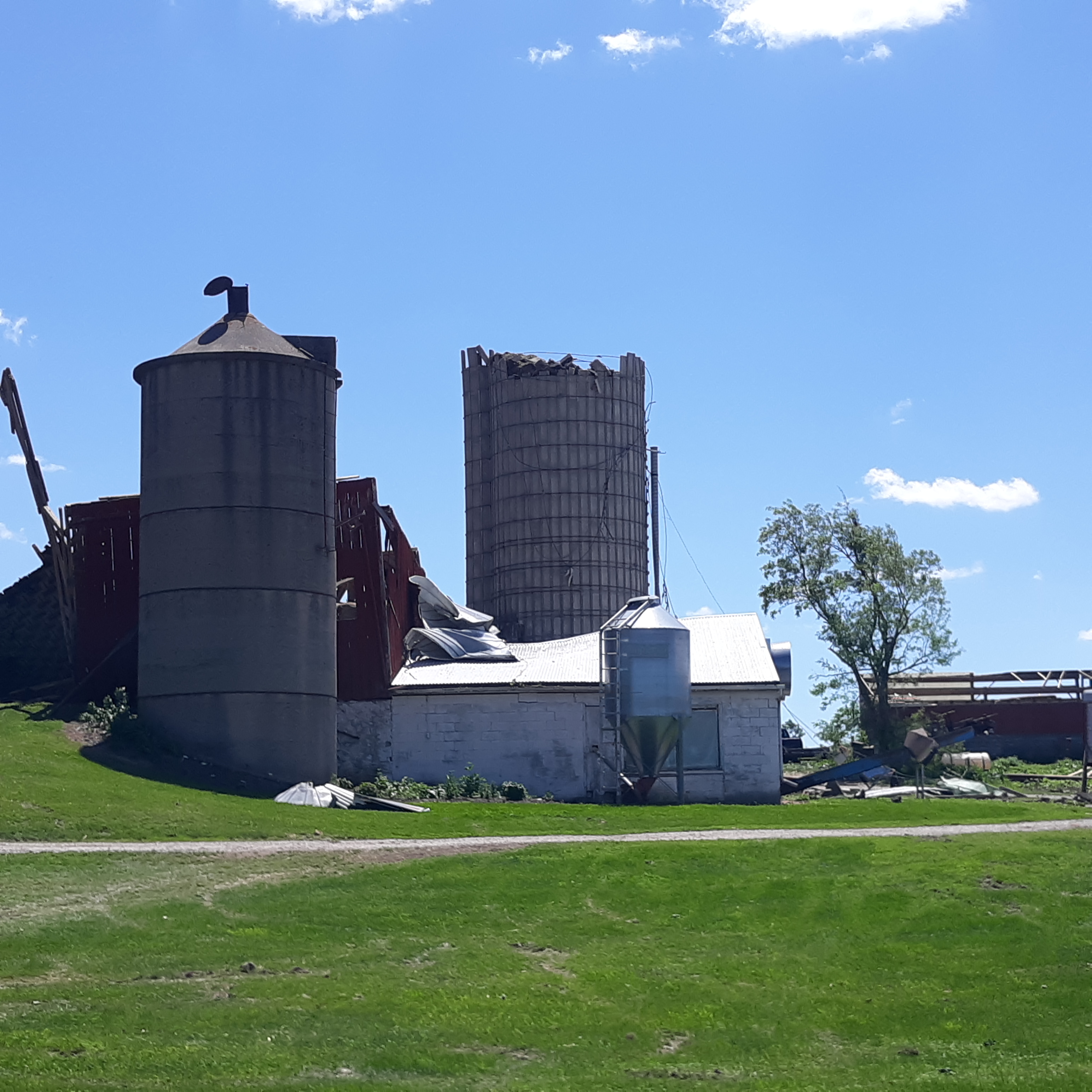
0609 PM TORNADO 1 NE LEEMAN 44.57N 88.53W
06/15/2022 OUTAGAMIE WI NWS STORM SURVEY
EF-1 TORNADO. 94 MPH MAX WIND SPEEDS.
6/15/22 6:09 PM - 6:18 PM. DAMAGE SURVEY
CONDUCTED BY NWS ON 6/16/22. DAMAGE TO FARM
BUILDINGS AND SILOS. TREES HAD TRUNKS
SNAPPED. DELAYED REPORT.
0610 PM TSTM WND DMG 1 WSW MENASHA 44.19N 88.46W
06/15/2022 WINNEBAGO WI PUBLIC
0611 PM TSTM WND DMG NICHOLS 44.56N 88.46W
06/15/2022 OUTAGAMIE WI PUBLIC
BARN WAS REPORTED DOWN VIA EMERGENCY
MANAGER.
0612 PM TSTM WND DMG 1 NE MOUNTAIN 45.19N 88.47W
06/15/2022 OCONTO WI PUBLIC
TREES UPROOTED OR SNAPPED. ROOF WAS BLOWN
OFF.
0612 PM TSTM WND DMG 3 WNW FREEDOM 44.39N 88.34W
06/15/2022 OUTAGAMIE WI LAW ENFORCEMENT
EMERGENCY MANAGER REPORTS NUMEROUS TREES AND
POWER LINES DOWNED AND BLOCKING HIGHWAYS AND
ROADS BETWEEN BLACK CREEK AND FREEDOM. TIME
BASED ON RADAR ESTIMATE. DELAYED REPORT.
0614 PM TORNADO NAVARINO 44.61N 88.48W
06/15/2022 SHAWANO WI TRAINED SPOTTER
OBSERVED TORNADO TOUCHED DOWN IN NAVARINO.
0614 PM TORNADO NAVARINO 44.61N 88.48W
06/15/2022 SHAWANO WI NWS STORM SURVEY
DELAYED REPORT. STORM SURVEY TEAM CONFIRMED
AN EF1 TORNADO IN NAVARINO. ADDITIONAL
DETAILS WILL BE AVAILABLE IN THE NEXT FEW DAYS.
0614 PM TSTM WND DMG 1 NW APPLETON 44.27N 88.41W
06/15/2022 OUTAGAMIE WI TRAINED SPOTTER
MULTIPLE TREES SNAPPED AND POWER LINES DOWN.
0614 PM TSTM WND DMG 1 WNW APPLETON 44.27N 88.42W
06/15/2022 OUTAGAMIE WI TRAINED SPOTTER
TREES WERE SNAPPED AND POWER LINES DOWN.
0615 PM TSTM WND GST APPLETON 44.26N 88.40W
06/15/2022 M59 MPH OUTAGAMIE WI AWOS
0616 PM TSTM WND DMG 1 WNW APPLETON 44.27N 88.42W
06/15/2022 OUTAGAMIE WI PUBLIC
TREES AND POWER LINES DOWN.
0617 PM TORNADO SEYMOUR 44.51N 88.33W
06/15/2022 OUTAGAMIE WI NWS STORM SURVEY
EF1 TORNADO. NO INJURIES OR FATALITIES. TIME
ESTIMATED OFF RADAR.
0617 PM TSTM WND DMG 1 NE MOUNTAIN 45.19N 88.47W
06/15/2022 OCONTO WI PUBLIC
TREES UPROOTED OR SNAPPED.
0618 PM TSTM WND DMG SEYMOUR 44.51N 88.33W
06/15/2022 OUTAGAMIE WI PUBLIC
MULTIPLE TREES SNAPPED IN THE CITY.
0618 PM TSTM WND DMG ONEIDA 44.50N 88.19W
06/15/2022 BROWN WI PUBLIC
BARN REPORTED DOWN VIA EMERGENCY MANAGER.
0619 PM TSTM WND DMG 3 WNW ANGELICA 44.67N 88.36W
06/15/2022 SHAWANO WI NWS STORM SURVEY
NWS STORM SURVEY FOUND LARGE PORTION OF ROOF
UPLIFTED FROM METAL BUILDING SYSTEM.
ESTIMATED WIND SPEEDS OF 79 MPH. DELAYED
REPORT.
0623 PM TSTM WND DMG 2 SSW ROSE LAWN 44.56N 88.33W
06/15/2022 OUTAGAMIE WI PUBLIC
TREES AND POWER LINES DOWN.
0625 PM TSTM WND DMG 3 SW HOWARD 44.52N 88.10W
06/15/2022 BROWN WI TRAINED SPOTTER
TRAINED SPOTTER REPORTED MULTIPLE 12 TO 18
INCH DIAMETER TREES DOWN. TIME ESTIMATED VIA
RADAR. DELAYED REPORT.
0625 PM TSTM WND GST GREEN BAY 44.51N 88.00W
06/15/2022 M59 MPH BROWN WI OFFICIAL NWS OBS
0627 PM TSTM WND DMG GREEN BAY 44.51N 88.00W
06/15/2022 BROWN WI PUBLIC
MULTIPLE TREES DOWN ON LAREDO LANE.
0629 PM TSTM WND GST 3 NNW HOWARD 44.59N 88.09W
06/15/2022 M75 MPH BROWN WI MESONET
0630 PM TSTM WND DMG CRIVITZ 45.23N 88.02W
06/15/2022 MARINETTE WI PUBLIC
WIND ESTIMATED AROUND 60 MPH. TREES AND
POWER LINES DOWN.
0631 PM TSTM WND DMG 1 S HOWARD 44.55N 88.06W
06/15/2022 BROWN WI TRAINED SPOTTER
SEVERAL TREES DOWN. A FEW ROADS WERE
IMPASSABLE DUE TO THE FALLEN TREES.
0633 PM TSTM WND DMG ABRAMS 44.78N 88.06W
06/15/2022 OCONTO WI PUBLIC
MULTIPLE TREES DOWNED - TIME ESTIMATED VIA
RADAR.
0634 PM TORNADO 4 NNW CALDRON FALLS RES 45.43N 88.30W
06/15/2022 MARINETTE WI NWS STORM SURVEY
TOWN OF SILVER CLIFF. EXTENSIVE DAMAGE TO
TREES, BARNS AND FARMSTEADS. DAMAGE TO LOCAL
FIRE DEPARTMENT BUILDING. TIME ESTIMATED BY
RADAR.
0639 PM TSTM WND DMG 2 NNW WAUSAUKEE 45.38N 87.96W
06/15/2022 MARINETTE WI LAW ENFORCEMENT
REPORT OF TREES DOWN AND COLLAPSED ROOFS.
TIME AND LOCATION ESTIMATED FROM RADAR.
DELAYED REPORT.
0639 PM TSTM WND DMG NEW FRANKEN 44.53N 87.83W
06/15/2022 BROWN WI PUBLIC
20 INCH BRANCHES DOWN.
0644 PM TORNADO 11 SW PEMBINE 45.51N 88.14W
06/15/2022 MARINETTE WI NWS STORM SURVEY
DELAYED REPORT. SURVEY TEAM CONFIRMED AN EF1 TORNADO
NORTHWEST OF AMBERG WISCONSIN. TIME ESTIMATED VIA RADAR.
0659 PM TSTM WND DMG 4 SSE POTAWATOMI STATE 44.82N 87.40W
06/15/2022 DOOR WI FIRE DEPT/RESCUE
FIRE DEPARTMENT REPORT OF MULTIPLE TREES AND
POWER LINES DOWN NEAR STURGEON BAY AND WI
HWY 42. TIME ESTIMATED FROM RADAR.
0702 PM     TORNADO          3 NE KREMLIN            45.68N 87.79W
06/15/2022                   MARINETTE          WI   NWS STORM SURVEY

            DELAYED REPORT. NWS SURVEY TEAM CONFIRMED AN EF1 TORNADO
            TO THE EAST NORTHEAST OF PEMBINE. TIME ESTIMATED VIA
            RADAR. MORE DETAILS TO FOLLOW.

0735 PM     TSTM WND GST     WASHINGTON ISLAND       45.38N 86.90W
06/15/2022  M46 MPH          DOOR               WI   AWOS


0754 PM     HEAVY RAIN       1 SE HAZELHURST         45.78N 89.70W
06/15/2022  M1.14 INCH       ONEIDA             WI   PUBLIC


1027 PM     HAIL             TWO RIVERS              44.15N 87.57W
06/15/2022  M1.25 INCH       MANITOWOC          WI   PUBLIC


1029 PM     HAIL             1 NW TWO RIVERS         44.16N 87.57W
06/15/2022  E1.50 INCH       MANITOWOC          WI   TRAINED SPOTTER

            GUSTY WINDS ALSO OCCURRED.
Rainfall:
Public Information Statement
National Weather Service Green Bay WI
954 AM CDT Thu Jun 16 2022

...PRECIPITATION REPORTS LAST 24 HOURS...

Location                     Amount    Time/Date       Lat/Lon

...Wisconsin...

...Brown County...
Wrightstown 4 NNE            0.94 in   0700 AM 06/16   44.40N/88.14W
Green Bay Airport(NWS)       0.92 in   0853 AM 06/16   44.48N/88.13W
Green Bay                    0.92 in   0600 AM 06/16   44.50N/88.11W
Green Bay                    0.77 in   0930 AM 06/16   44.49N/88.09W
Green Bay                    0.72 in   0939 AM 06/16   44.58N/88.09W
Green Bay                    0.69 in   0935 AM 06/16   44.50N/88.01W
Ashwaubenon 2 NNE            0.64 in   0945 AM 06/16   44.49N/88.07W
De Pere                      0.61 in   0940 AM 06/16   44.44N/88.05W
Green Bay 1 ESE              0.58 in   0940 AM 06/16   44.50N/87.98W
Green Bay 1 WNW              0.52 in   0944 AM 06/16   44.51N/88.01W
Green Bay 7.1 WNW            0.50 in   0700 AM 06/16   44.57N/88.12W
Wrightstown                  0.42 in   0936 AM 06/16   44.33N/88.17W
Suamico 4.4 WNW              0.41 in   0700 AM 06/16   44.66N/88.12W

...Calumet County...
Hilbert 5.9 WSW              0.72 in   0459 AM 06/16   44.11N/88.27W
Chilton 1 W                  0.65 in   0944 AM 06/16   44.03N/88.17W
Chilton 0.5 E                0.57 in   0700 AM 06/16   44.03N/88.15W
Appleton 4.6 ESE             0.50 in   0720 AM 06/16   44.23N/88.32W
Brillion                     0.49 in   0730 AM 06/16   44.18N/88.07W
Brillion 4.9 S               0.38 in   0700 AM 06/16   44.11N/88.05W
New Holstein 1 W             0.33 in   0945 AM 06/16   43.95N/88.10W
Forest Junction              0.25 in   0938 AM 06/16   44.21N/88.21W

...Door County...
Baileys Harbor 3 ENE         0.57 in   0700 AM 06/16   45.09N/87.07W
Ellison Bay 1 ENE            0.51 in   0700 AM 06/16   45.26N/87.03W
Potawatomi State Park 3 SE   0.50 in   0940 AM 06/16   44.83N/87.40W
Ellison Bay 0.0 SE           0.45 in   0700 AM 06/16   45.25N/87.07W
Sister Bay 1 N               0.45 in   0700 AM 06/16   45.20N/87.11W
Washington Island            0.43 in   0530 AM 06/16   45.36N/86.89W
Potawatomi State Park 4 ESE  0.42 in   0944 AM 06/16   44.83N/87.36W
Egg Harbor 3.7 SSE           0.38 in   0700 AM 06/16   45.00N/87.26W
Sturgeon Bay Exp Farm        0.36 in   0730 AM 06/16   44.87N/87.33W
Ephraim                      0.35 in   0935 AM 06/16   45.13N/87.18W
Fish Creek 1 E WWTP          0.33 in   0700 AM 06/16   45.12N/87.23W
Washington Island            0.33 in   0935 AM 06/16   45.38N/86.92W
1.9 NW Carlsville            0.20 in   0530 AM 06/16   44.97N/87.36W
Washington Island 1 WSW      0.20 in   0945 AM 06/16   45.36N/86.93W

...Florence County...
Florence                     0.90 in   0700 AM 06/16   45.93N/88.26W
Spread Eagle 1 NW            0.55 in   0700 AM 06/16   45.89N/88.14W

...Forest County...
Laona 1.4 WSW                0.95 in   0700 AM 06/16   45.56N/88.70W
Wabeno 2 NNW                 0.69 in   0701 AM 06/16   45.46N/88.68W
Crandon                      0.35 in   0935 AM 06/16   45.52N/88.85W

...Kewaunee County...
2 SSE Dyckesville            0.30 in   0741 AM 06/16   44.61N/87.74W
2 E Rankin                   0.23 in   0945 AM 06/16   44.60N/87.44W
Luxemburg 3.2 ESE            0.20 in   0610 AM 06/16   44.53N/87.65W
Casco 0.4 NNW                0.09 in   0520 AM 06/16   44.56N/87.62W

...Langlade County...
Antigo 1 SSW                 0.57 in   0800 AM 06/16   45.13N/89.15W
Antigo 2 ENE                 0.52 in   0205 AM 06/16   45.16N/89.11W
White Lake 1.4 SE            0.33 in   0800 AM 06/16   45.15N/88.74W

...Lincoln County...
2.7 NE Spirit Falls          1.15 in   0830 AM 06/16   45.48N/89.95W
Tomahawk 1.2 SSW             1.09 in   0700 AM 06/16   45.46N/89.73W
Tomahawk 4.6 N               0.75 in   0700 AM 06/16   45.54N/89.71W
Merrill 14.1 W               0.75 in   0700 AM 06/16   45.15N/89.99W
Merrill 8 W                  0.27 in   0600 AM 06/16   45.18N/89.85W

...Manitowoc County...
Manitowoc                    1.69 in   0940 AM 06/16   44.09N/87.66W
Millhome 2 E                 1.04 in   0632 AM 06/16   43.90N/87.91W
St Nazianz                   0.79 in   0940 AM 06/16   44.01N/87.89W
TWO RIVERS                   0.61 in   0939 AM 06/16   44.15N/87.56W
Two Rivers                   0.58 in   0700 AM 06/16   44.14N/87.57W
Manitowoc                    0.50 in   0936 AM 06/16   44.08N/87.68W
Manitowoc                    0.45 in   0940 AM 06/16   44.12N/87.64W
Two Rivers 2 NW              0.42 in   0540 AM 06/16   44.18N/87.58W
Brillion 2 SSE               0.40 in   0800 AM 06/16   44.14N/88.04W
Whitelaw                     0.35 in   0940 AM 06/16   44.18N/87.84W

...Marathon County...
Stratford 4 W                0.79 in   0940 AM 06/16   44.81N/90.17W
Moon 6 SW                    0.78 in   0205 AM 06/16   44.70N/89.87W
Moon 1 E                     0.75 in   0500 AM 06/16   44.77N/89.77W
Mosinee                      0.74 in   0931 AM 06/16   44.86N/89.68W
Wausau 5.4 SSW               0.74 in   0700 AM 06/16   44.89N/89.69W
Wausau 2.4 W                 0.74 in   0800 AM 06/16   44.96N/89.69W
Spencer - Wwtp               0.65 in   0730 AM 06/16   44.75N/90.29W
Athens 0.6 SSW               0.58 in   0800 AM 06/16   45.03N/90.08W
Evergreen 1 E                0.57 in   0700 AM 06/16   44.84N/89.60W
Weston 1 NE                  0.53 in   0700 AM 06/16   44.92N/89.54W
Wausau 1 ENE                 0.51 in   0700 AM 06/16   44.97N/89.61W
Wausau                       0.50 in   0939 AM 06/16   44.95N/89.64W
Wausau                       0.49 in   0931 AM 06/16   44.95N/89.61W
Wausau 1 SSE                 0.48 in   0945 AM 06/16   44.94N/89.62W
Evergreen 1.5 WSW            0.48 in   0700 AM 06/16   44.84N/89.67W
Mosinee 2 W                  0.44 in   0700 AM 06/16   44.77N/89.73W
Rothschild 0.5 ENE           0.43 in   0700 AM 06/16   44.89N/89.61W
Dancy 1 NNW                  0.37 in   0700 AM 06/16   44.70N/89.70W
1 NW Knowlton                0.28 in   0620 AM 06/16   44.73N/89.70W
Stratford 1 NW               0.25 in   0621 AM 06/16   44.82N/90.09W

...Marinette County...
Marinette - Wps              0.85 in   0652 AM 06/16   45.24N/88.01W
Quinnesec 1 S                0.75 in   0944 AM 06/16   45.78N/88.00W
Peshtigo 1 S                 0.45 in   0730 AM 06/16   45.03N/87.74W
Peshtigo 1 N                 0.26 in   0945 AM 06/16   45.06N/87.75W
Wausaukee 2 NW               0.25 in   0205 AM 06/16   45.39N/87.97W
Menominee 1.6 S              0.22 in   0730 AM 06/16   45.10N/87.62W
Athelstane 2 SW              0.16 in   0940 AM 06/16   45.40N/88.12W

...Menominee County...
Keshena 2 WNW                0.52 in   0205 AM 06/16   44.89N/88.66W
Keshena 4 NE                 0.46 in   0945 AM 06/16   44.92N/88.57W

...Oconto County...
Townsend 1.7 NNW             0.94 in   0600 AM 06/16   45.35N/88.61W
Suring                       0.88 in   0800 AM 06/16   45.00N/88.38W
Pound 9.0 WNW                0.86 in   0645 AM 06/16   45.13N/88.21W
Breed 5 NE                   0.76 in   0703 AM 06/16   45.12N/88.37W
Lakewood                     0.47 in   0930 AM 06/16   45.31N/88.47W
Mountain 0.9 E               0.30 in   0700 AM 06/16   45.18N/88.46W
Oconto Falls 3 E             0.28 in   0944 AM 06/16   44.87N/88.14W
Pulaski - WWTP               0.25 in   0600 AM 06/16   44.68N/88.23W

...Oneida County...
Rhinelander 5 N              1.25 in   0700 AM 06/16   45.71N/89.42W
Rhinelander Airport          1.15 in   0853 AM 06/16   45.63N/89.48W
Hazelhurst 2.1 SSE           1.14 in   0700 AM 06/16   45.78N/89.70W
Rhinelander                  1.06 in   1030 PM 06/15   45.62N/89.41W
Rhinelander 4 NE             0.95 in   0600 AM 06/16   45.65N/89.31W
Rhinelander 2 SW             0.92 in   0730 AM 06/16   45.60N/89.45W
Tomahawk 3 W                 0.92 in   0910 AM 06/16   45.59N/89.72W
Bradley 2 NNW                0.88 in   0936 AM 06/16   45.56N/89.77W
Willow                       0.85 in   0600 AM 06/16   45.70N/89.83W
Arbor Vitae - Woodruff 2 S   0.81 in   0910 AM 06/16   45.89N/89.65W

...Outagamie County...
Grand Chute                  0.88 in   0939 AM 06/16   44.31N/88.42W
Greenville                   0.86 in   0937 AM 06/16   44.29N/88.52W
Appleton                     0.86 in   0207 AM 06/16   44.29N/88.46W
Mackville 2 S                0.83 in   0515 AM 06/16   44.31N/88.41W
Appleton 2.5 NW              0.81 in   0800 AM 06/16   44.30N/88.43W
Appleton                     0.75 in   0500 AM 06/16   44.28N/88.44W
Appleton 1.6 E               0.62 in   0730 AM 06/16   44.27N/88.36W
Appleton                     0.57 in   0945 AM 06/16   44.26N/88.40W
Kaukauna 1 W                 0.55 in   0445 AM 06/16   44.26N/88.29W
Appleton 1 N                 0.51 in   0700 AM 06/16   44.29N/88.39W
Kaukauna                     0.49 in   0930 AM 06/16   44.25N/88.28W
New London 2 SE              0.45 in   0630 AM 06/16   44.36N/88.72W
Black Creek 5.6 WNW          0.38 in   0700 AM 06/16   44.52N/88.55W

...Portage County...
Stevens Point                1.10 in   0700 AM 06/16   44.51N/89.59W
Plover                       0.92 in   0936 AM 06/16   44.44N/89.55W
Rosholt                      0.89 in   0800 AM 06/16   44.63N/89.31W
Plover                       0.88 in   0937 AM 06/16   44.48N/89.54W
Stevens Point Airport        0.70 in   0935 AM 06/16   44.55N/89.53W
Almond 5 NE                  0.49 in   0800 AM 06/16   44.31N/89.35W

...Shawano County...
Bonduel 3.3 NW               1.68 in   0700 AM 06/16   44.78N/88.49W
Cecil 5.6 ENE                0.69 in   0700 AM 06/16   44.85N/88.35W
Cecil                        0.50 in   0932 AM 06/16   44.85N/88.35W
Pella 3 SE                   0.34 in   0530 AM 06/16   44.74N/88.74W
Shawano Airport              0.29 in   0935 AM 06/16   44.78N/88.57W
Pulaski 3.7 W                0.17 in   0700 AM 06/16   44.67N/88.31W

...Vilas County...
Arbor Vitae-Johnson Lake     1.64 in   0601 AM 06/16   45.90N/89.73W
Phelps 4.2 N                 1.09 in   0712 AM 06/16   46.12N/89.08W
Phelps 2 SW                  0.77 in   0702 AM 06/16   46.04N/89.10W
Eagle River - South          0.75 in   0659 AM 06/16   45.91N/89.24W
Land O Lakes                 0.70 in   0935 AM 06/16   46.15N/89.22W
Boulder Junction 9 ENE       0.67 in   0700 AM 06/16   46.19N/89.46W
Winchester                   0.52 in   0935 AM 06/16   46.23N/89.83W
Boulder Junction 1.4 NE      0.50 in   0700 AM 06/16   46.13N/89.62W
3 SSE Lac Du Flambeau        0.48 in   0700 AM 06/16   45.91N/89.86W
Land O Lakes 3 W             0.44 in   0945 AM 06/16   46.17N/89.30W
Manitowish Waters 0.6 S      0.44 in   0700 AM 06/16   46.12N/89.88W
Manitowish Waters Airport    0.33 in   0935 AM 06/16   46.12N/89.88W

...Waupaca County...
Waupaca                      0.82 in   0935 AM 06/16   44.33N/89.02W
Waupaca 1 E                  0.70 in   0600 AM 06/16   44.35N/89.06W
Waupaca                      0.68 in   0937 AM 06/16   44.34N/89.11W
New London - WWTP            0.65 in   0700 AM 06/16   44.39N/88.75W
Iola 0.4 SSW                 0.29 in   0500 AM 06/16   44.50N/89.13W
New London 1 SW              0.27 in   0945 AM 06/16   44.37N/88.76W

...Waushara County...
Wild Rose 0.5 E              1.58 in   0600 AM 06/16   44.18N/89.24W
Wautoma 2 WNW                1.42 in   0945 AM 06/16   44.07N/89.31W
Wautoma 1 WSW                1.22 in   0912 AM 06/16   44.06N/89.29W
Wautoma 3 SE                 0.90 in   0630 AM 06/16   44.04N/89.24W
Berlin WWTP                  0.70 in   0700 AM 06/16   43.99N/88.94W

...Winnebago County...
Omro                         1.31 in   0935 AM 06/16   44.03N/88.75W
Omro 1 WSW                   0.83 in   0700 AM 06/16   44.02N/88.78W
Winneconne                   0.68 in   0900 AM 06/16   44.11N/88.71W
Omro 1 NNE                   0.63 in   0945 AM 06/16   44.04N/88.74W
Zittau                       0.63 in   0600 AM 06/16   44.22N/88.78W
Oshkosh Airport              0.58 in   0853 AM 06/16   43.97N/88.55W
Oshkosh 1.5 SSE              0.58 in   0700 AM 06/16   44.00N/88.54W
Oshkosh 2.0 W                0.54 in   0700 AM 06/16   44.02N/88.59W
Oshkosh                      0.52 in   0700 AM 06/16   44.03N/88.56W
Omro                         0.48 in   0906 AM 06/16   44.07N/88.69W
Oshkosh 0.8 NW               0.47 in   0700 AM 06/16   44.02N/88.57W
Neenah 1.1 ENE               0.39 in   0700 AM 06/16   44.17N/88.45W

...Wood County...
Kellner 3 WNW                1.49 in   0630 AM 06/16   44.36N/89.77W
Wisconsin Rapids             1.44 in   0935 AM 06/16   44.37N/89.77W
Pittsville - WWTP            1.40 in   0700 AM 06/16   44.44N/90.13W
Marshfield 5.6 SSW           1.20 in   0700 AM 06/16   44.59N/90.20W
Wisconsin Rapids Airport     1.14 in   0854 AM 06/16   44.37N/89.83W
Hewitt 0.8 N                 1.11 in   0730 AM 06/16   44.64N/90.13W
Wisconsin Rapids 1 ESE       0.77 in   0945 AM 06/16   44.39N/89.81W
Marshfield Airport           0.75 in   0854 AM 06/16   44.63N/90.18W
New Rome 4 ENE               0.65 in   0205 AM 06/16   44.26N/89.81W
Rudolph                      0.51 in   0945 AM 06/16   44.50N/89.79W

Observations are collected from a variety of sources with varying
equipment and exposures. We thank all volunteer weather observers
for their dedication. Not all data listed are considered official.
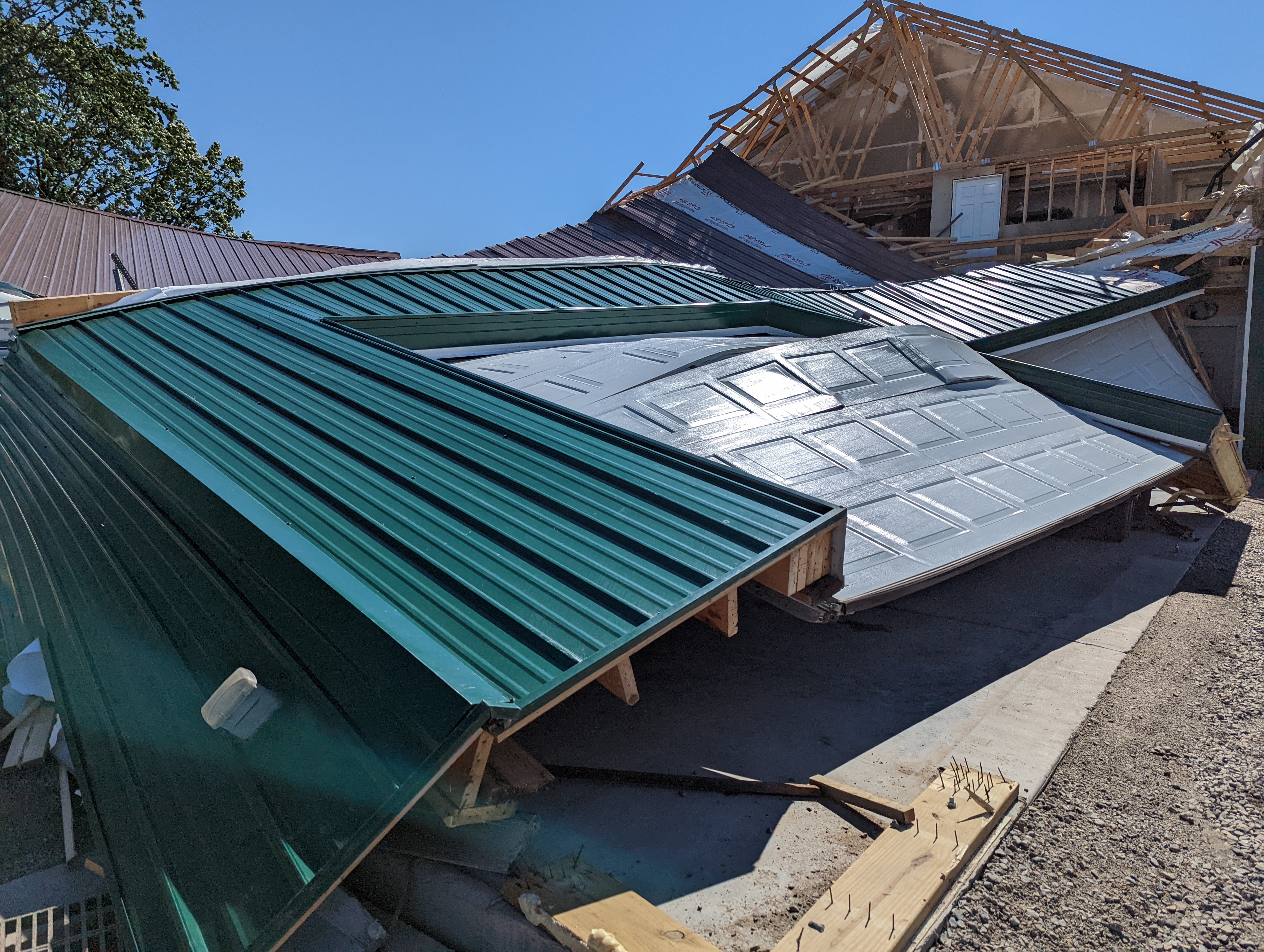
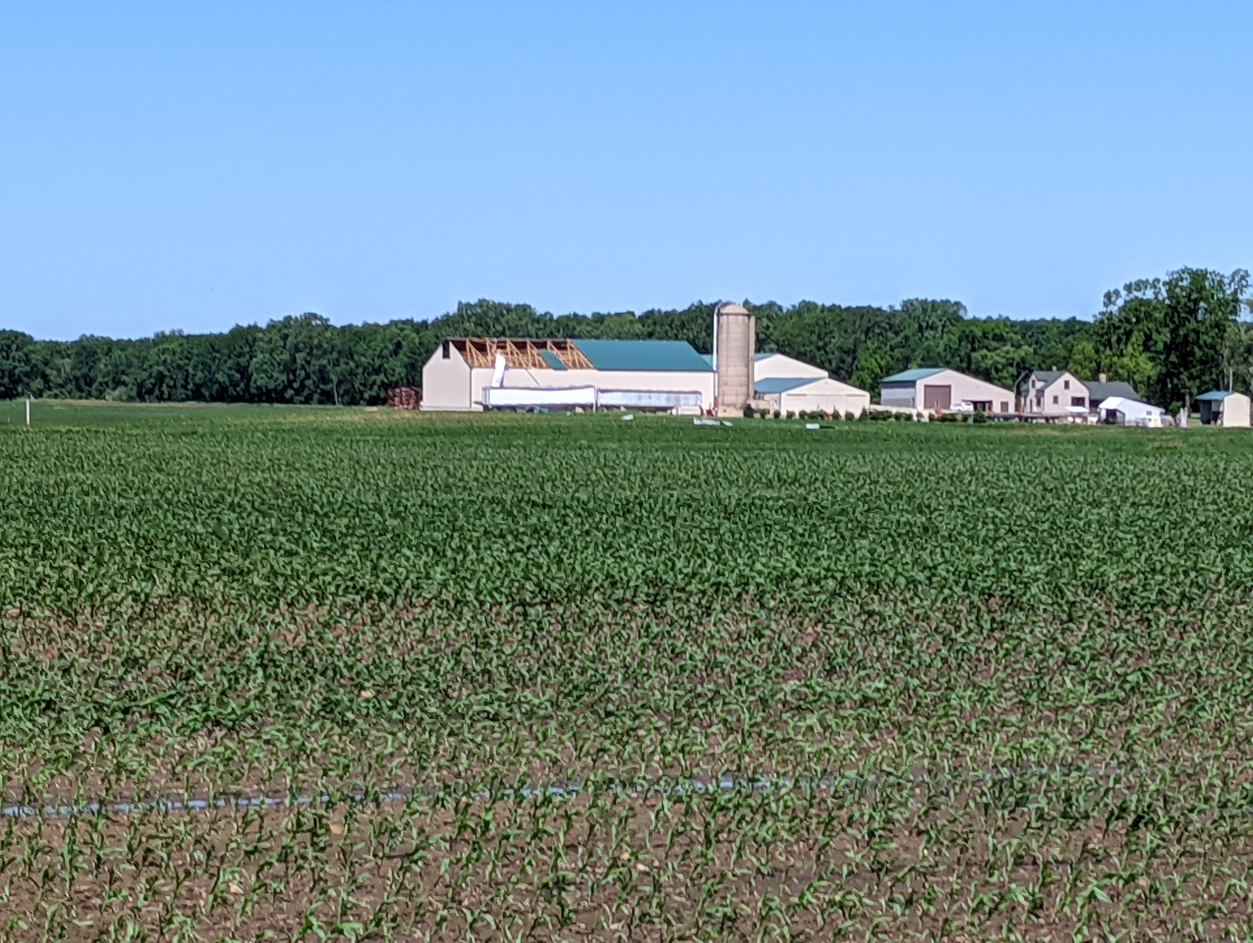
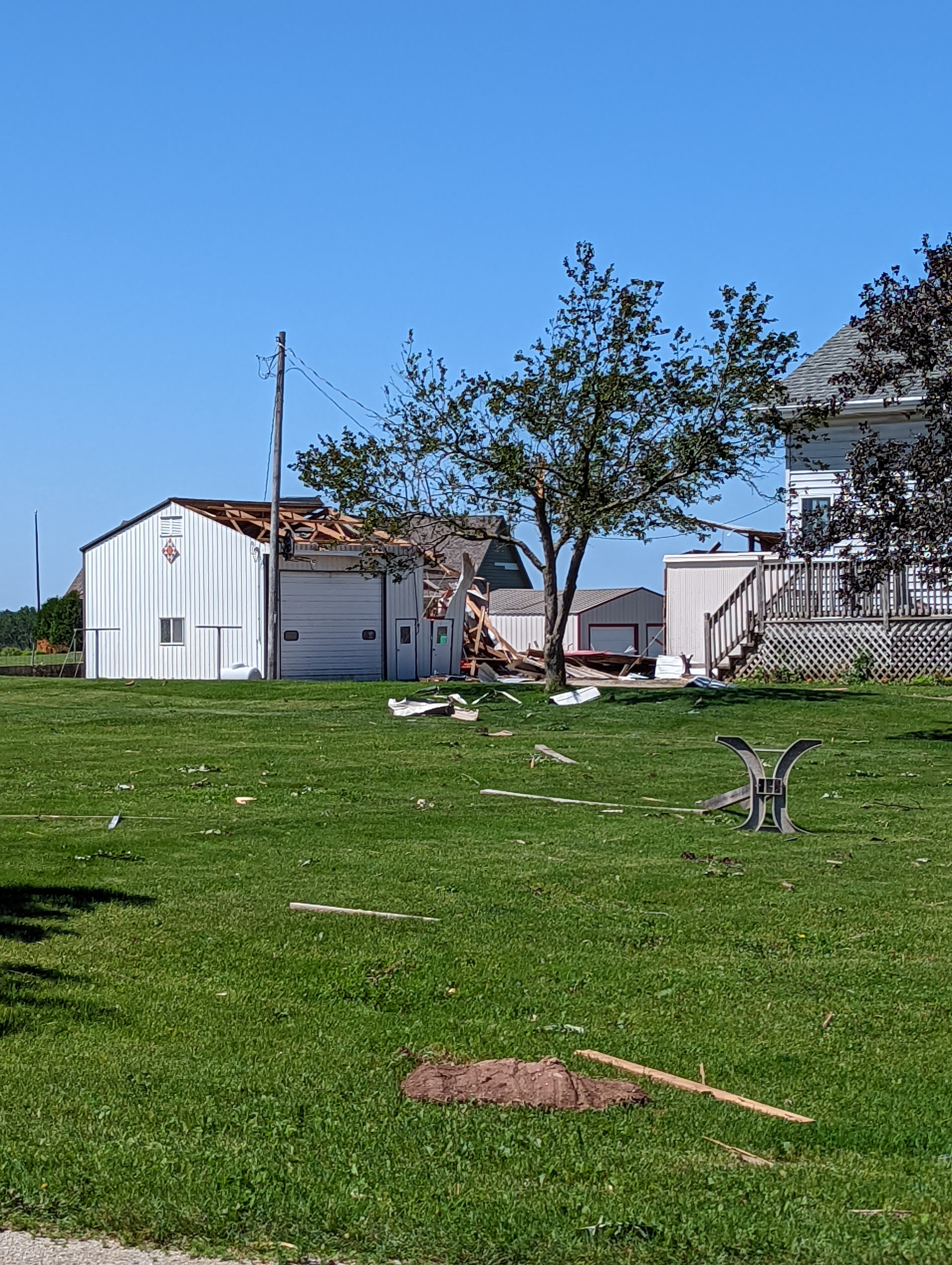
Photos
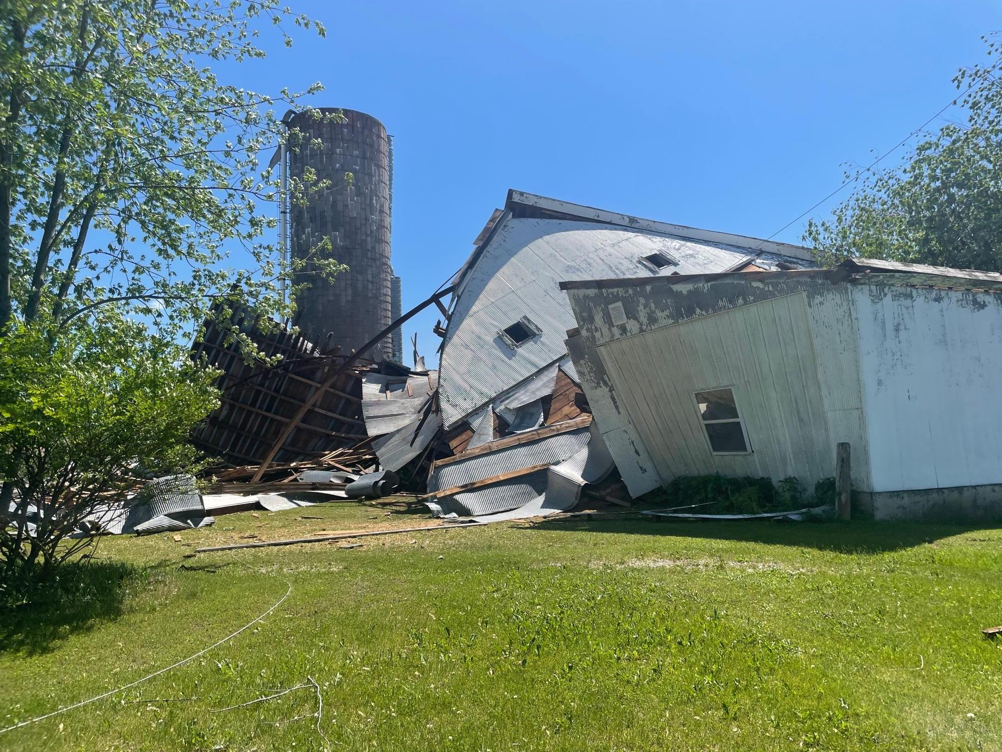
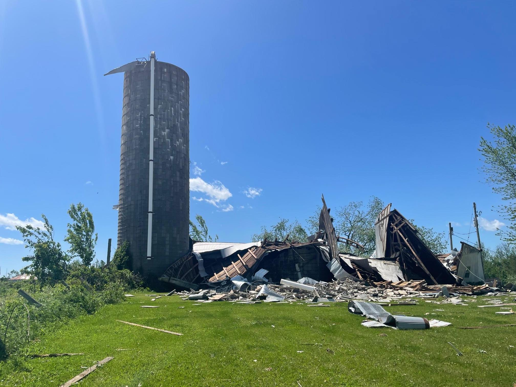
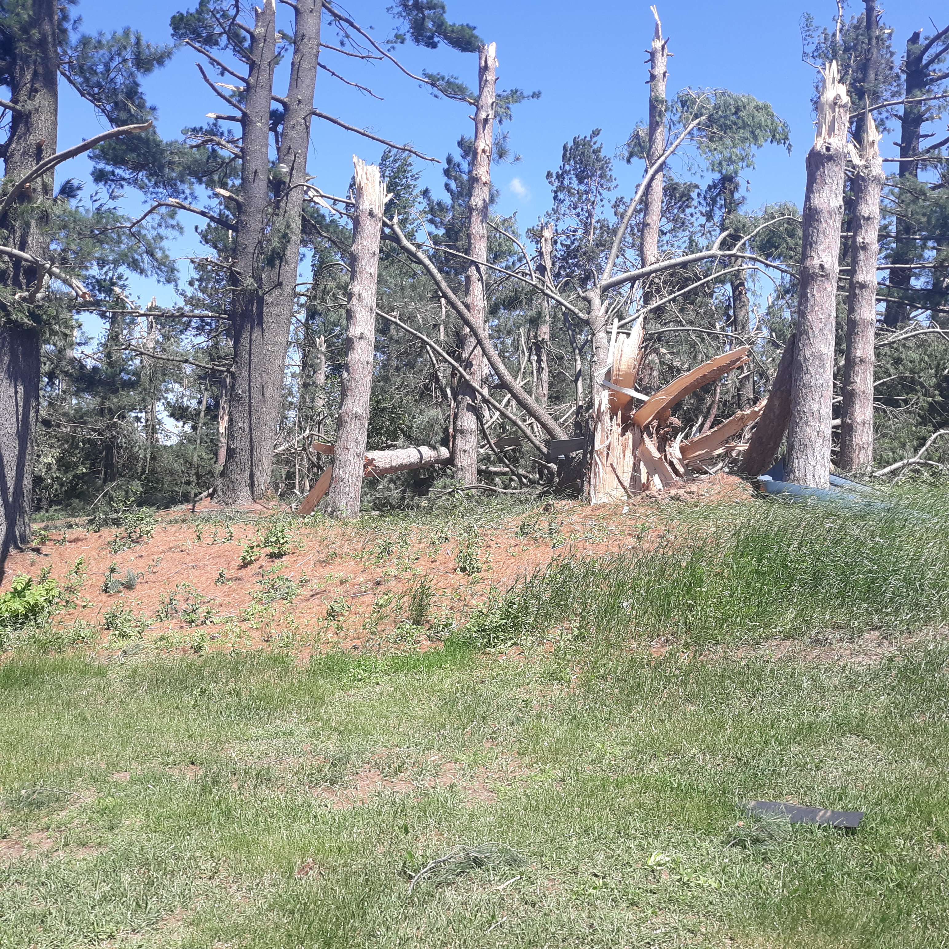
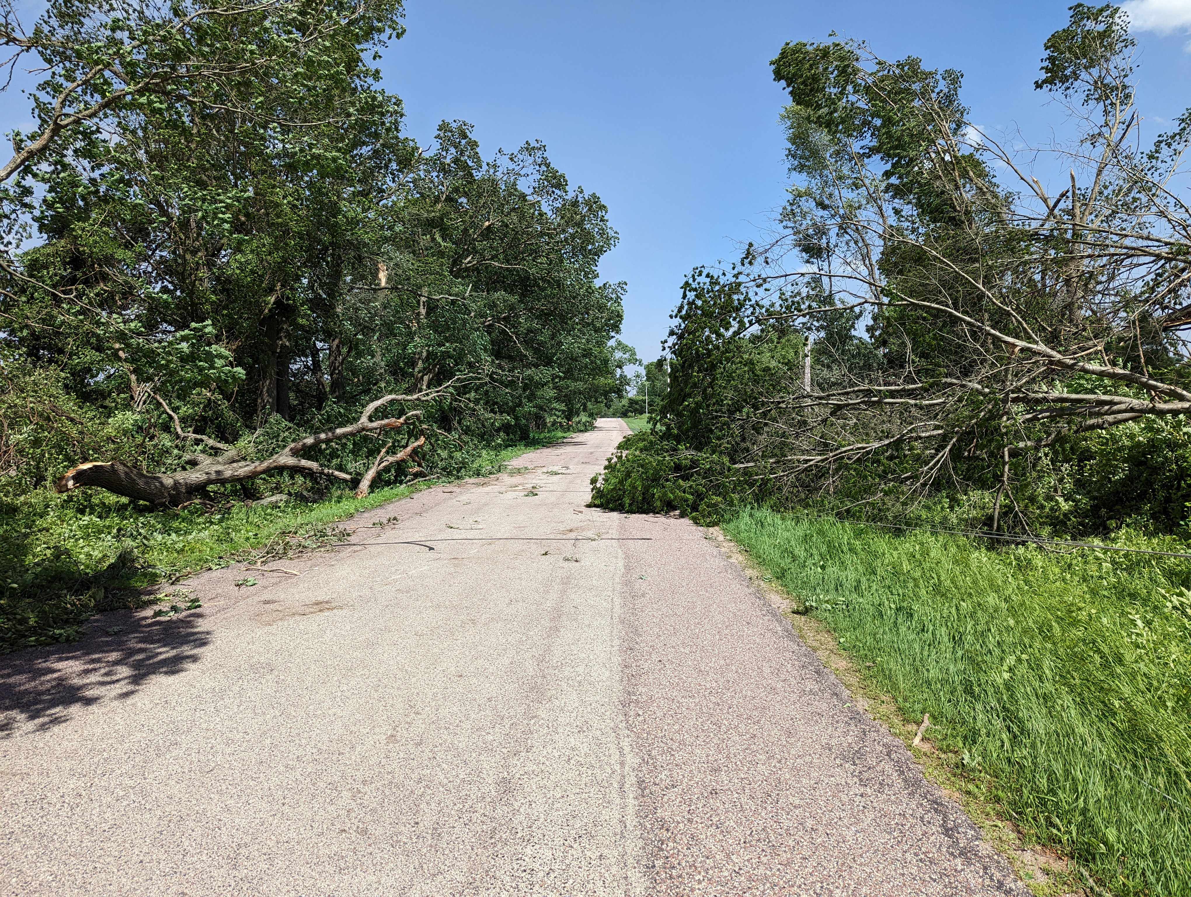
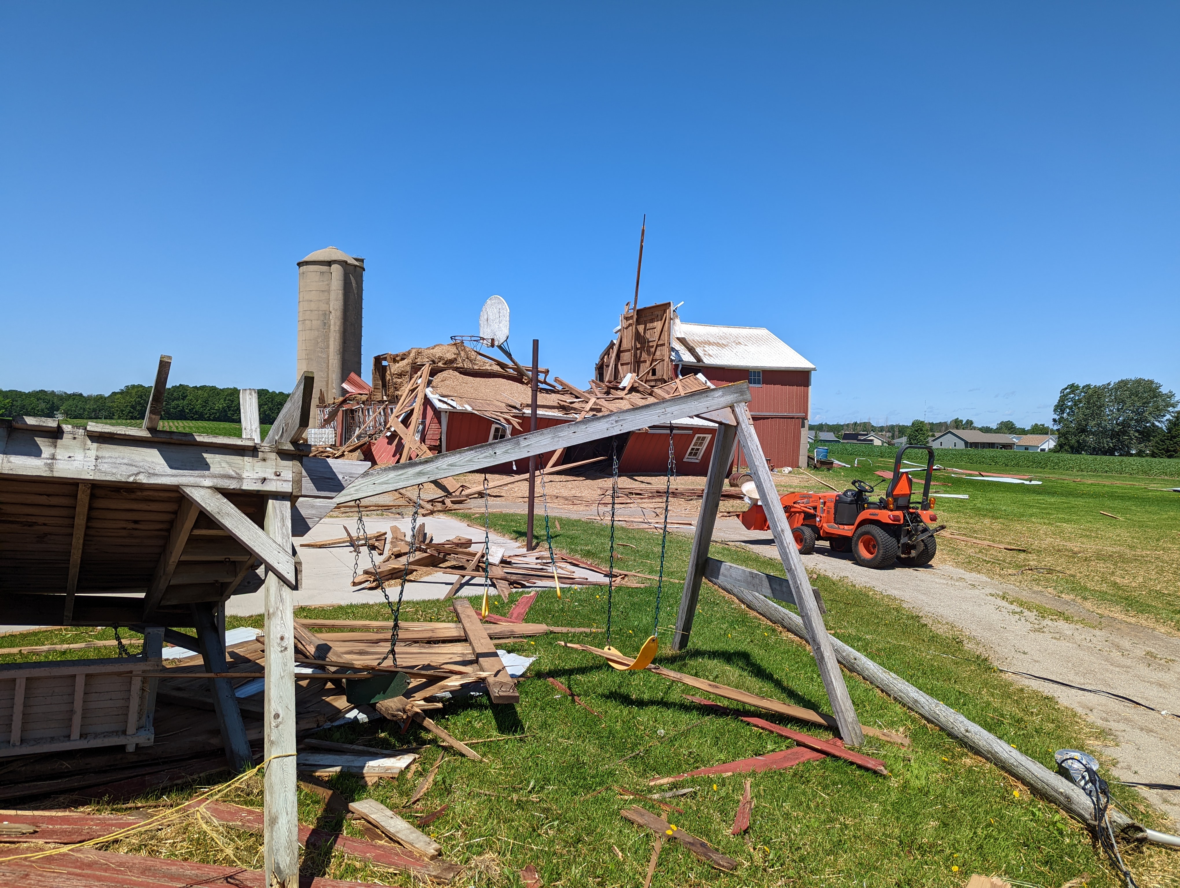
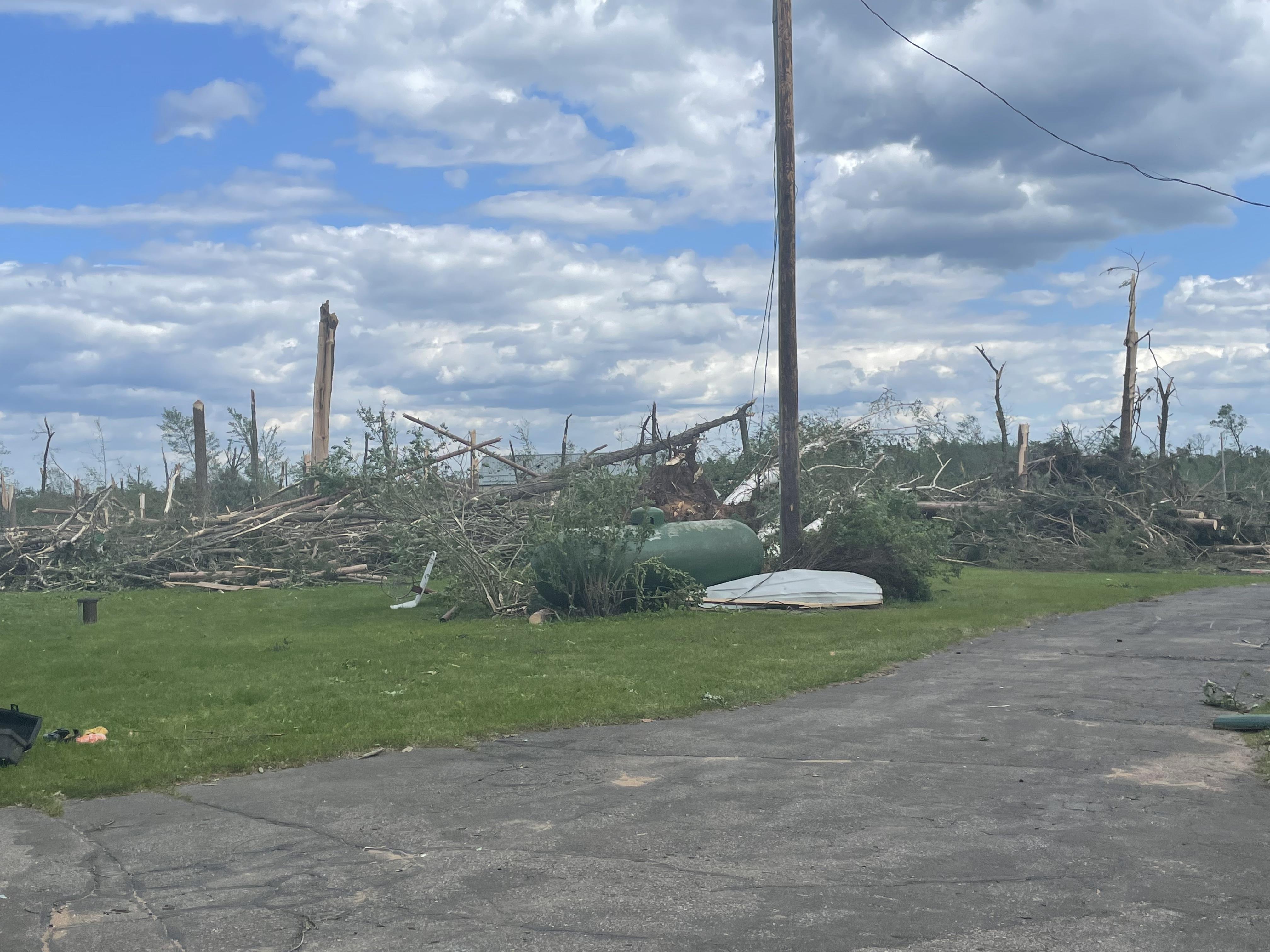 Silver Cliff (western Marinette Co.) |
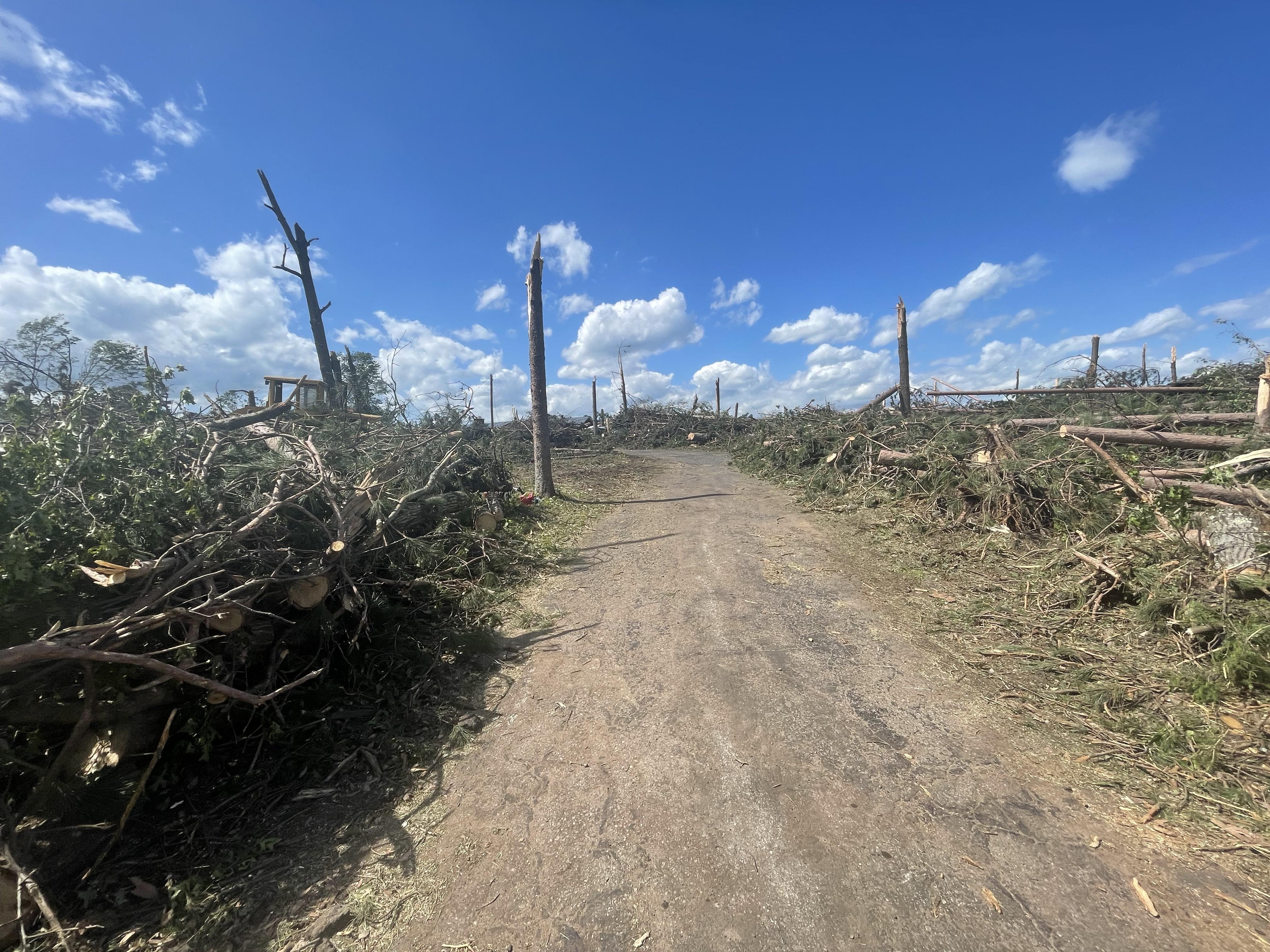 Silver Cliff (western Marinette Co.) |
 Silver Cliff (western Marinette Co.) |
 Silver Cliff (western Marinette Co.) |
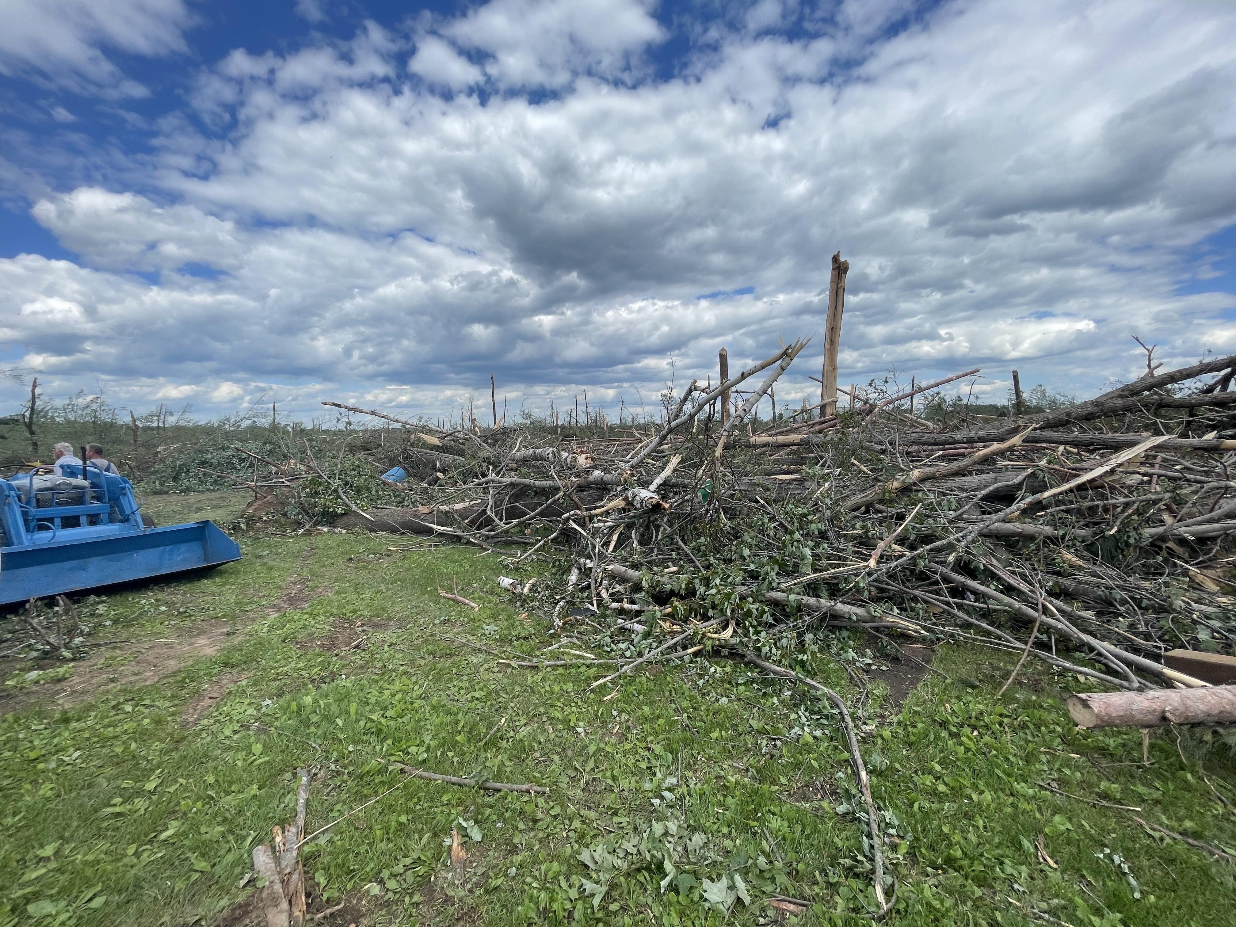
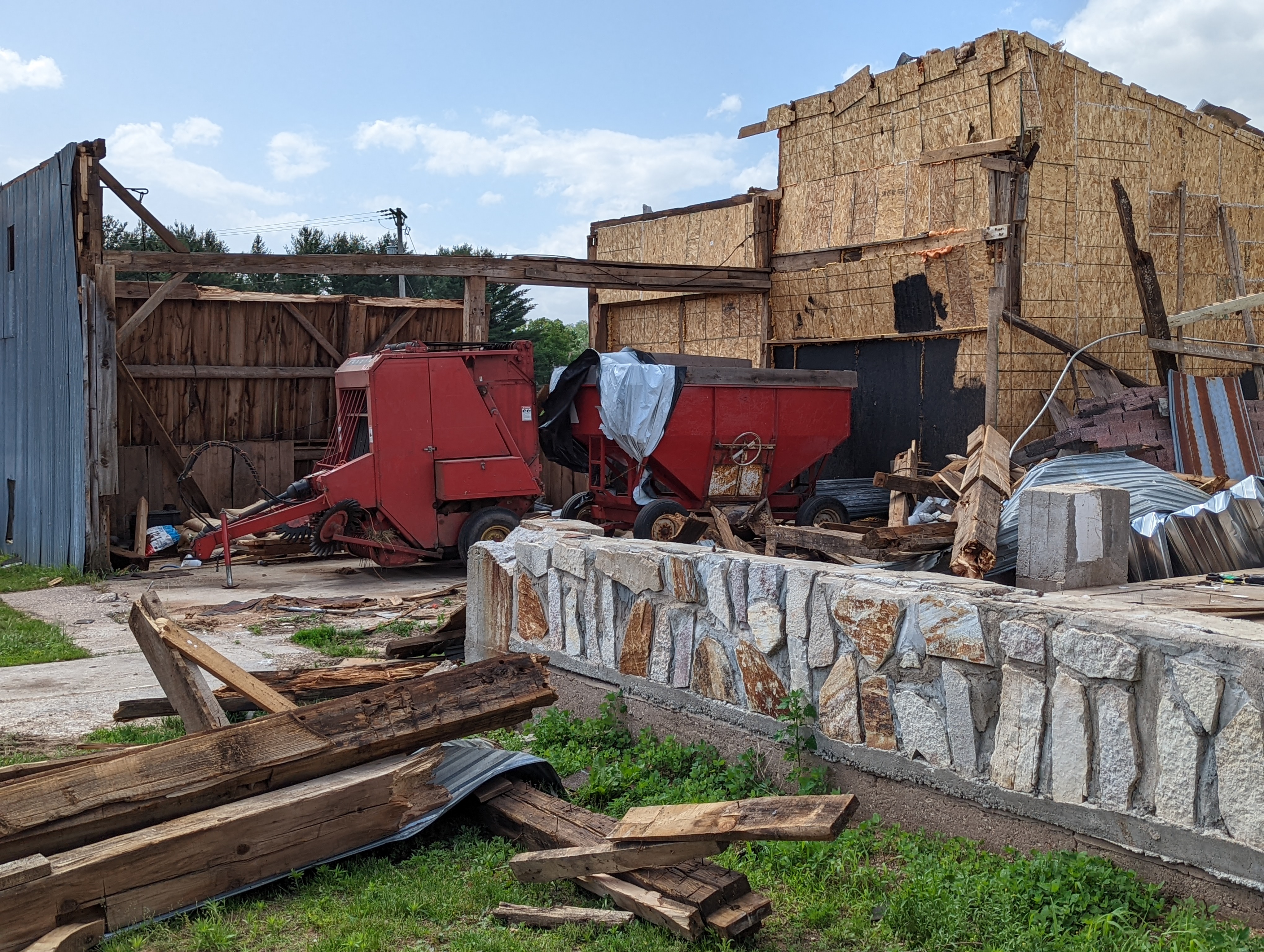
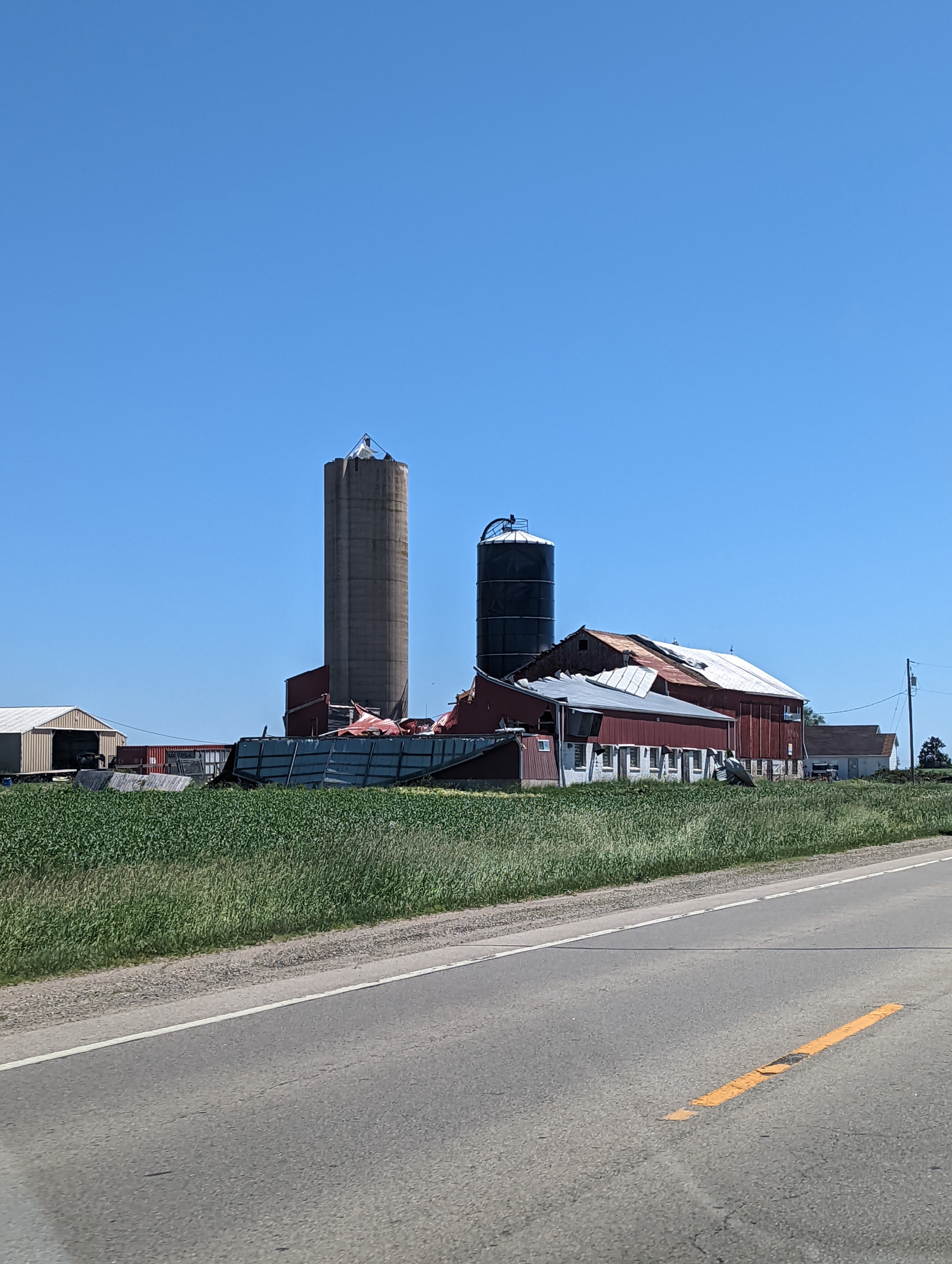
 Middle Inlet (northern Marinette Co.) |
 Middle Inlet (northern Marinette Co.) |
 Middle Inlet (northern Marinette Co.) |
 Middle Inlet (northern Marinette Co.) |
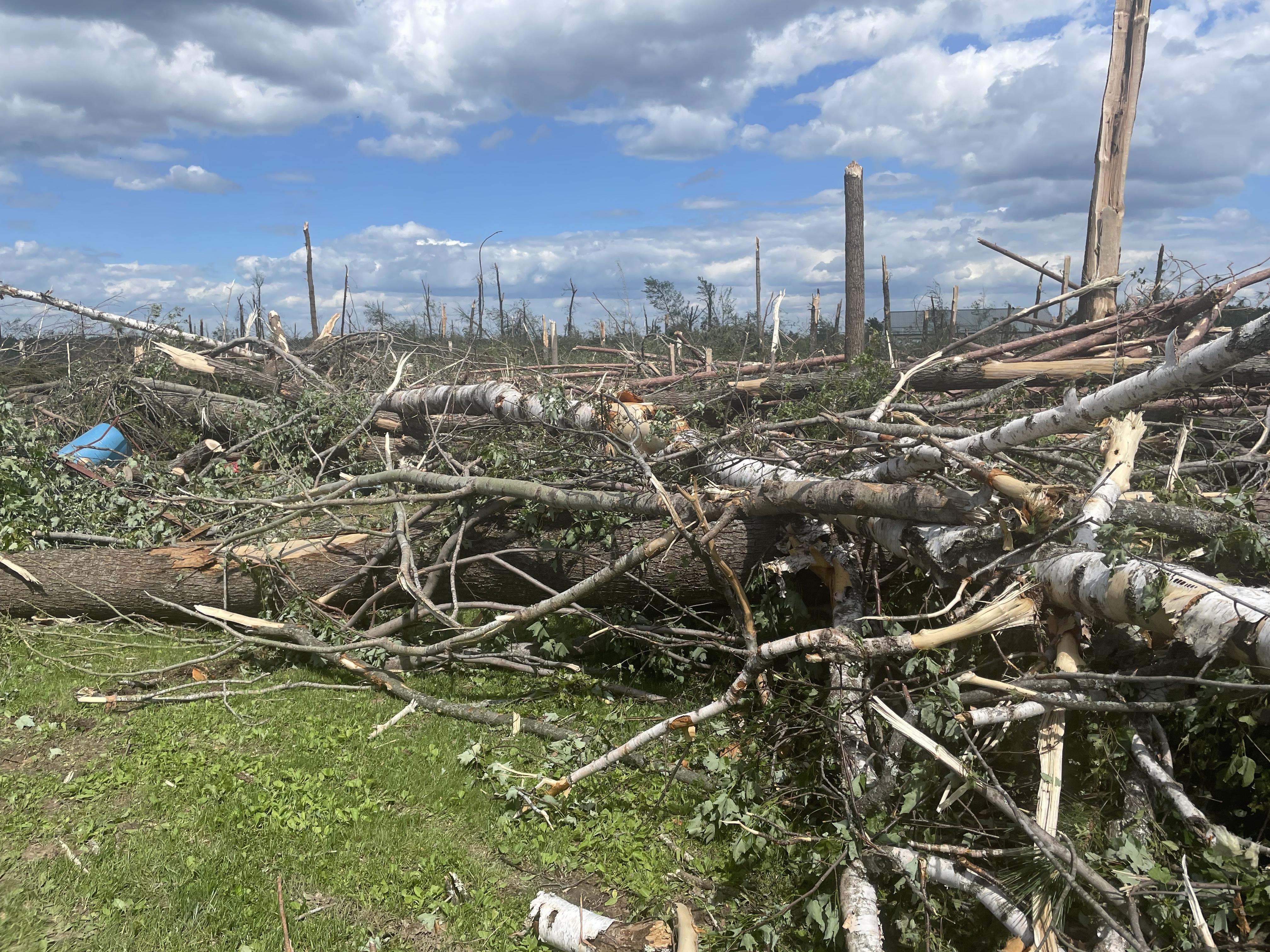
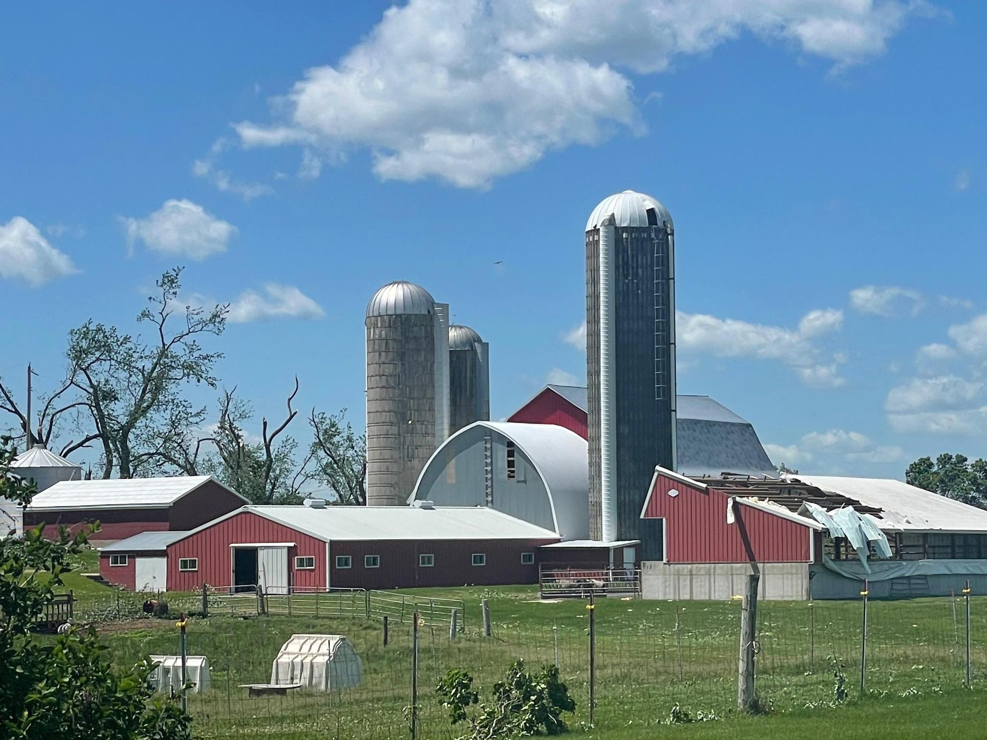
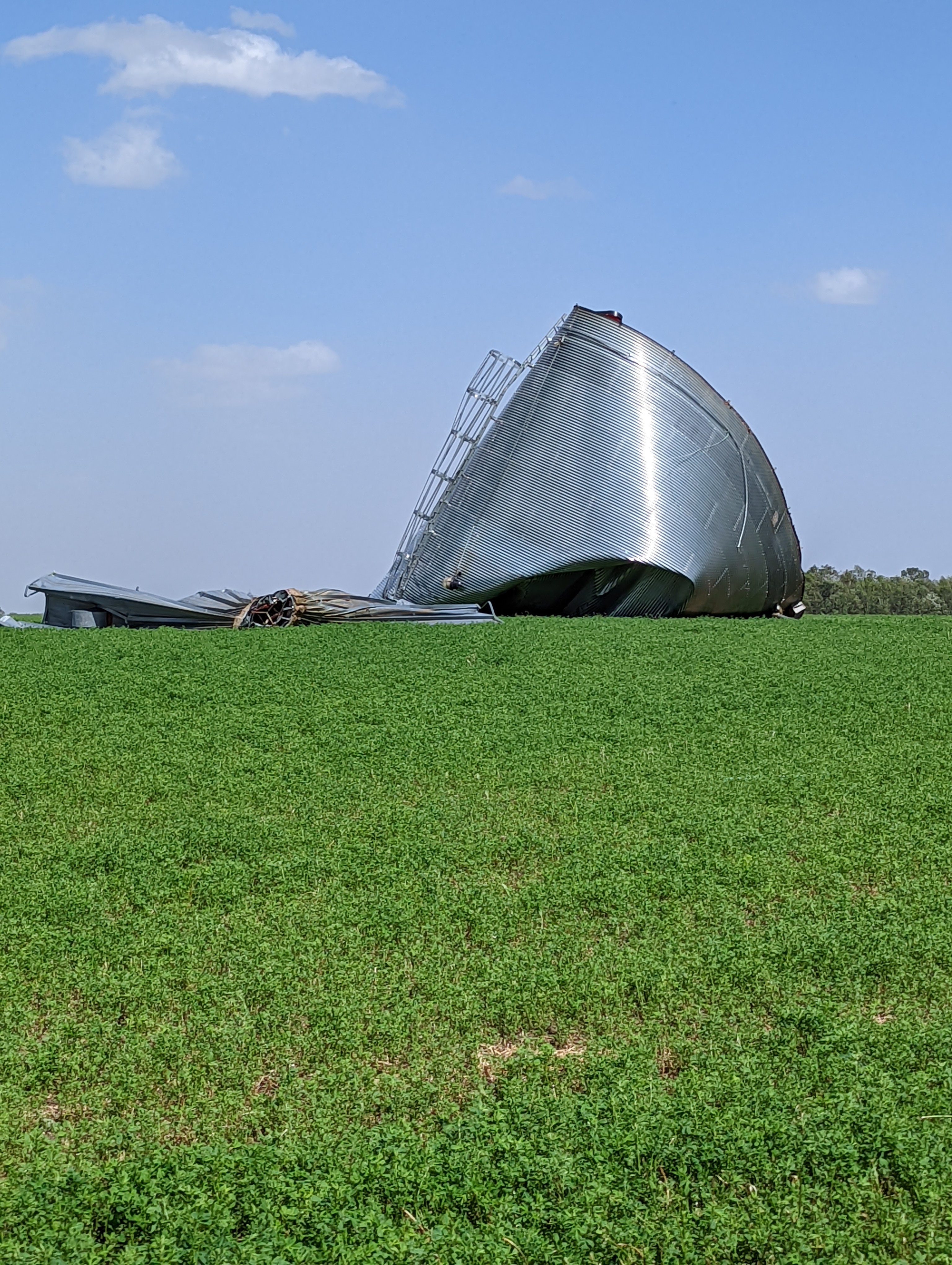
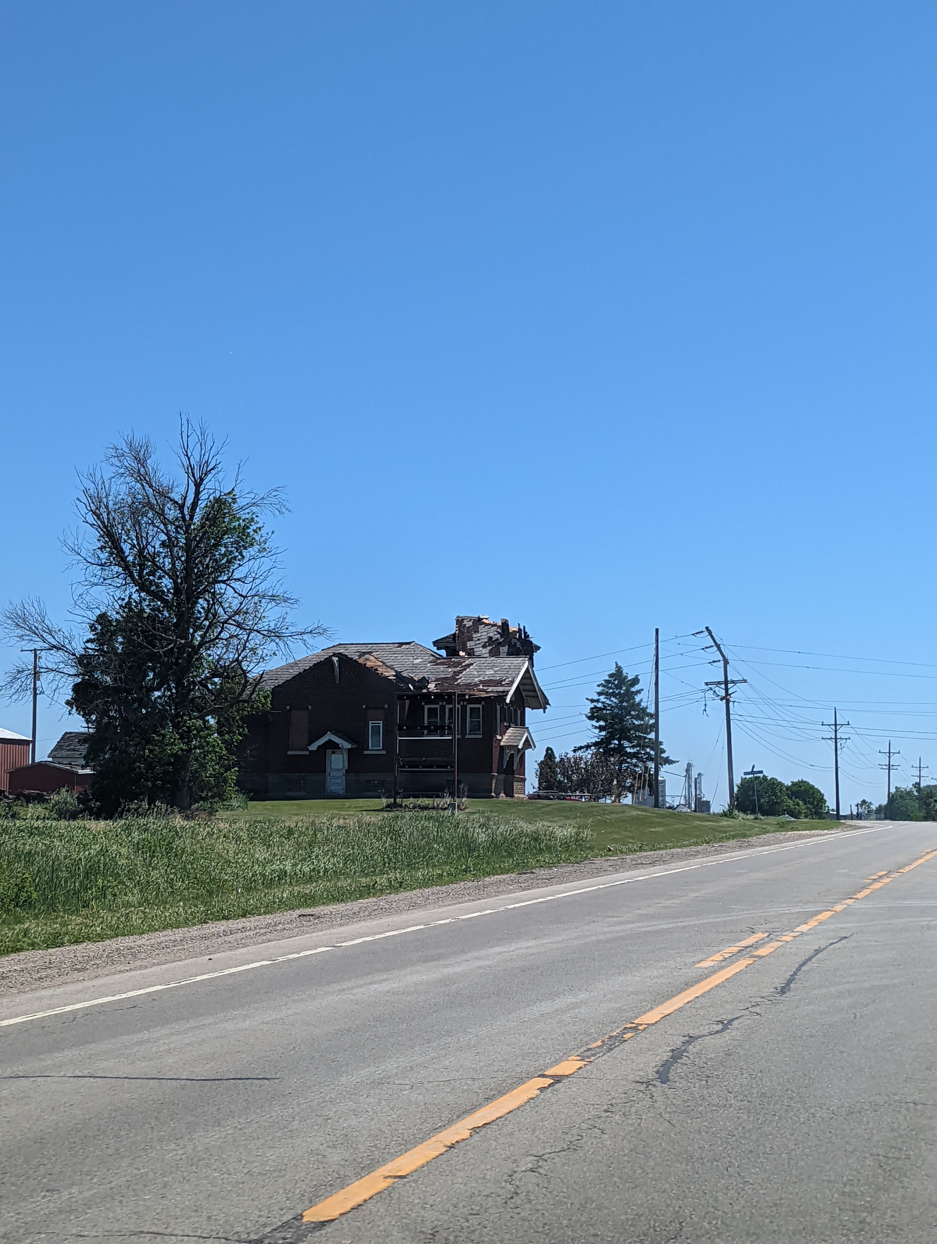
 Navarino (southeast Shawano Co.) |
 Navarino (southeast Shawano Co.) |
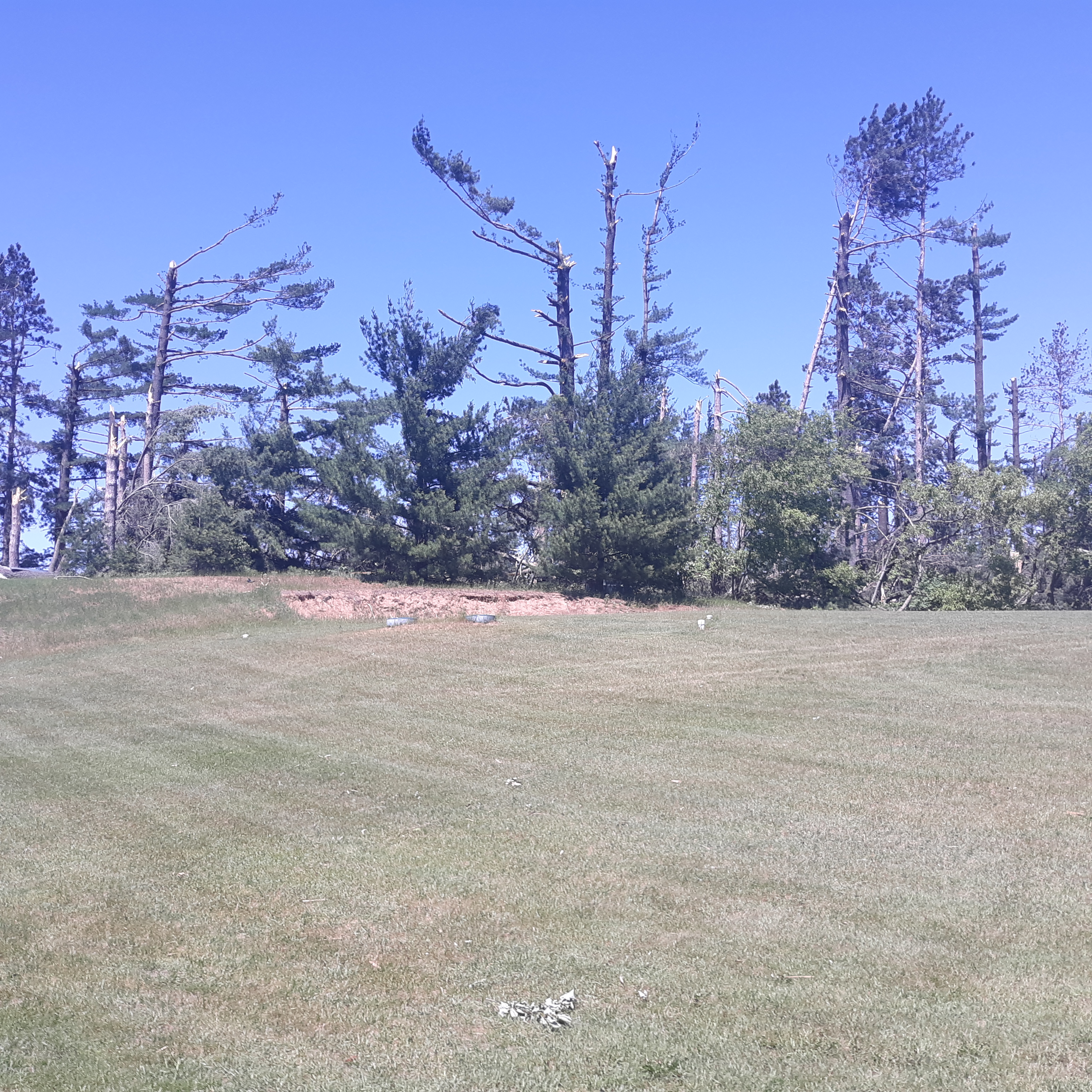 Navarino (southeast Shawano Co.) |
 Navarino (southeast Shawano Co.) |
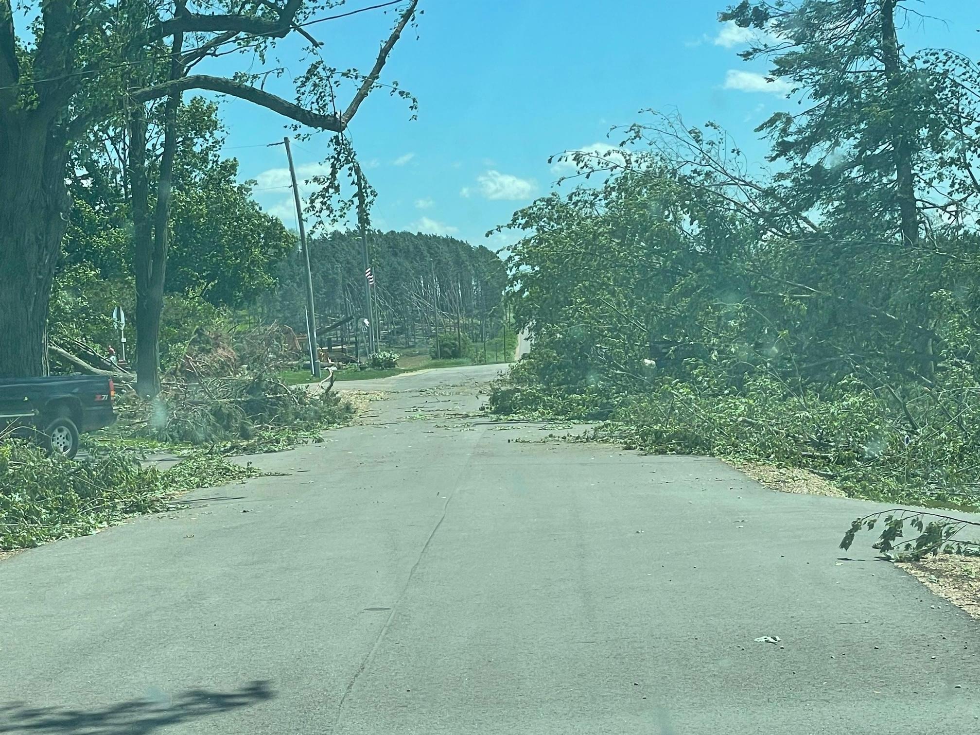
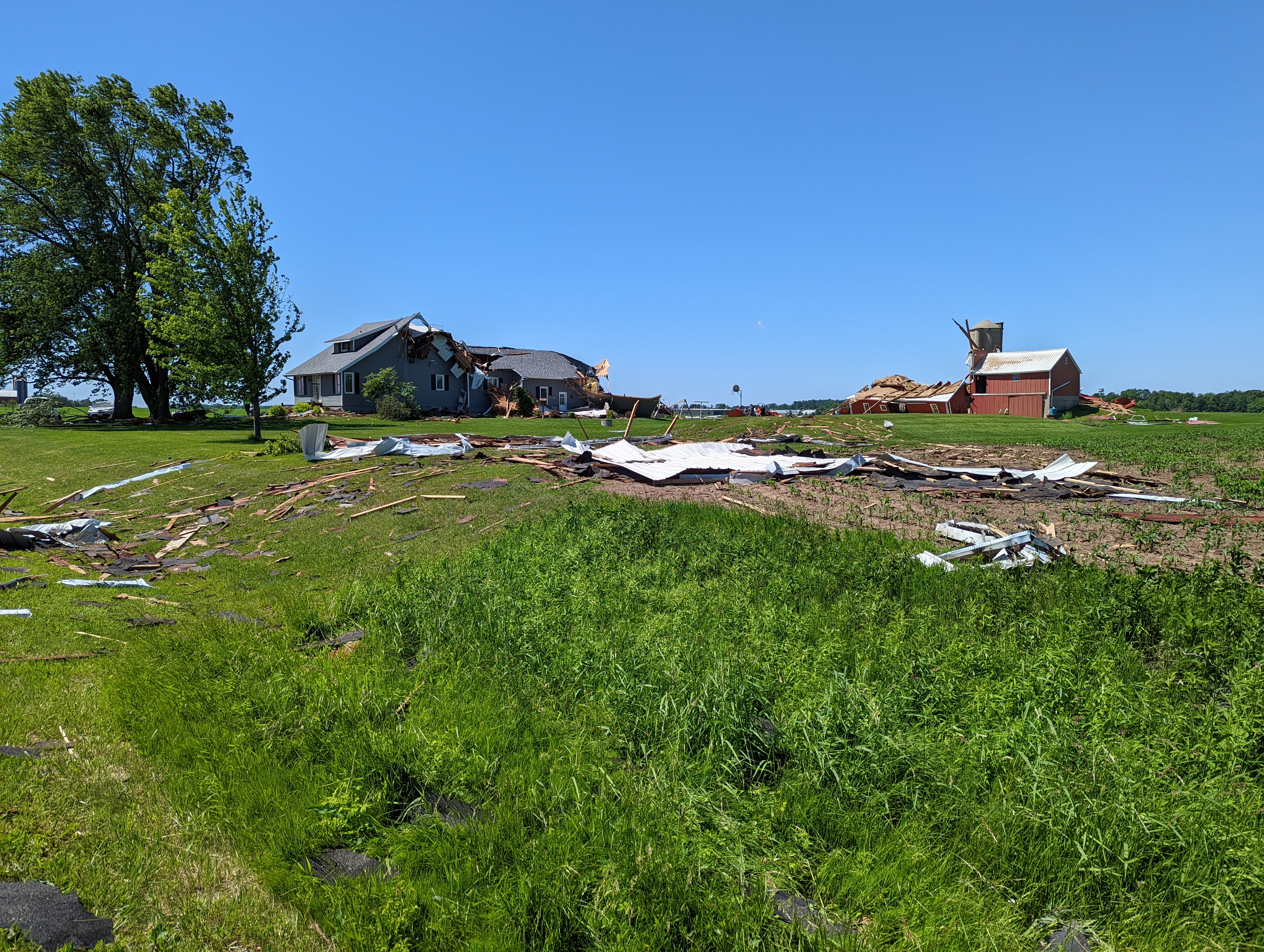
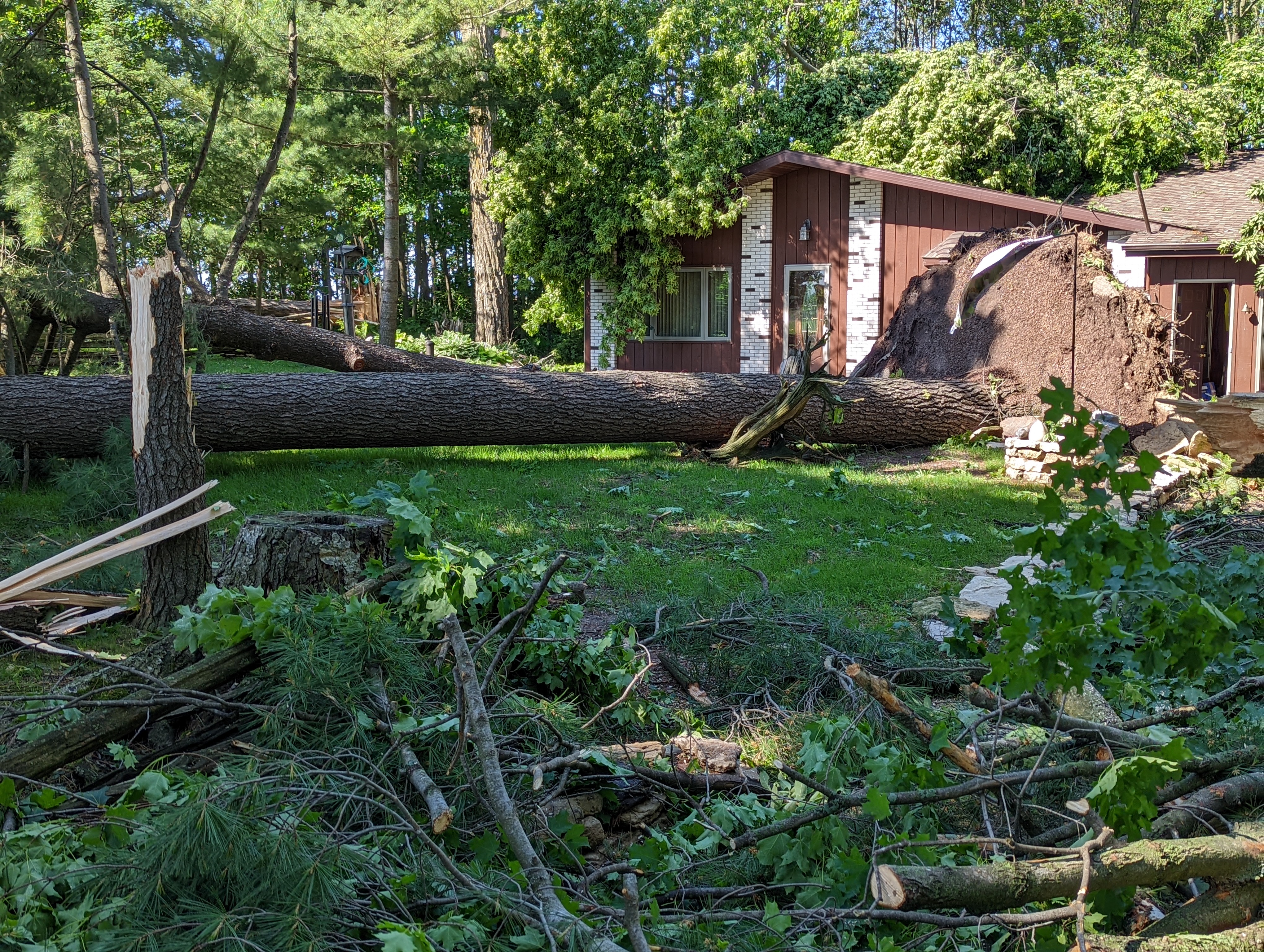
 West Bloomfield (eastern Waushara Co.) |
 West Bloomfield (eastern Waushara Co.) |
 West Bloomfield (eastern Waushara Co.) |
 West Bloomfield (eastern Waushara Co.) |
 Seymour (northeast Outagamie Co.) |
 Seymour (northeast Outagamie Co.) |
 Seymour (northeast Outagamie Co.) |
 Seymour (northeast Outagamie Co.) |
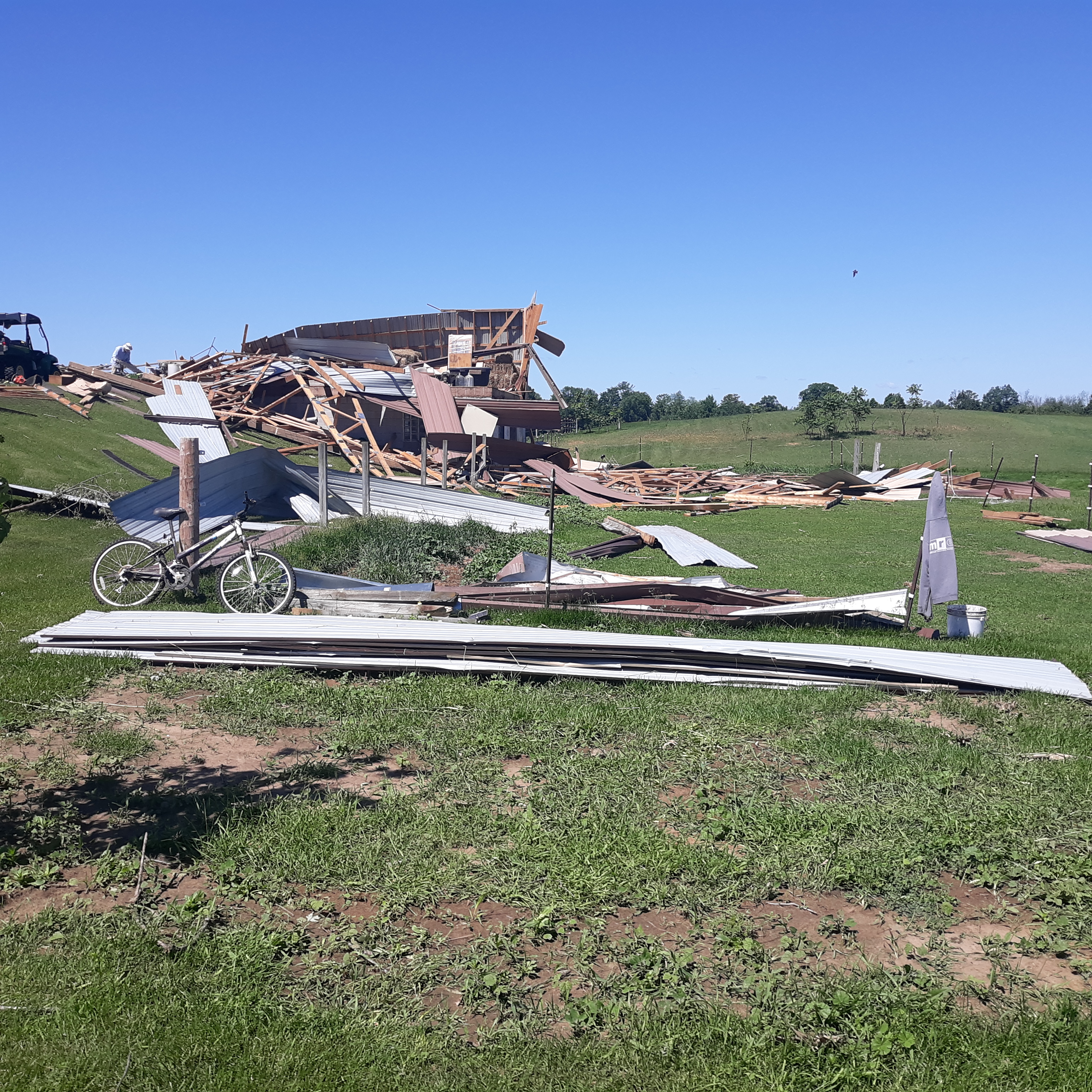
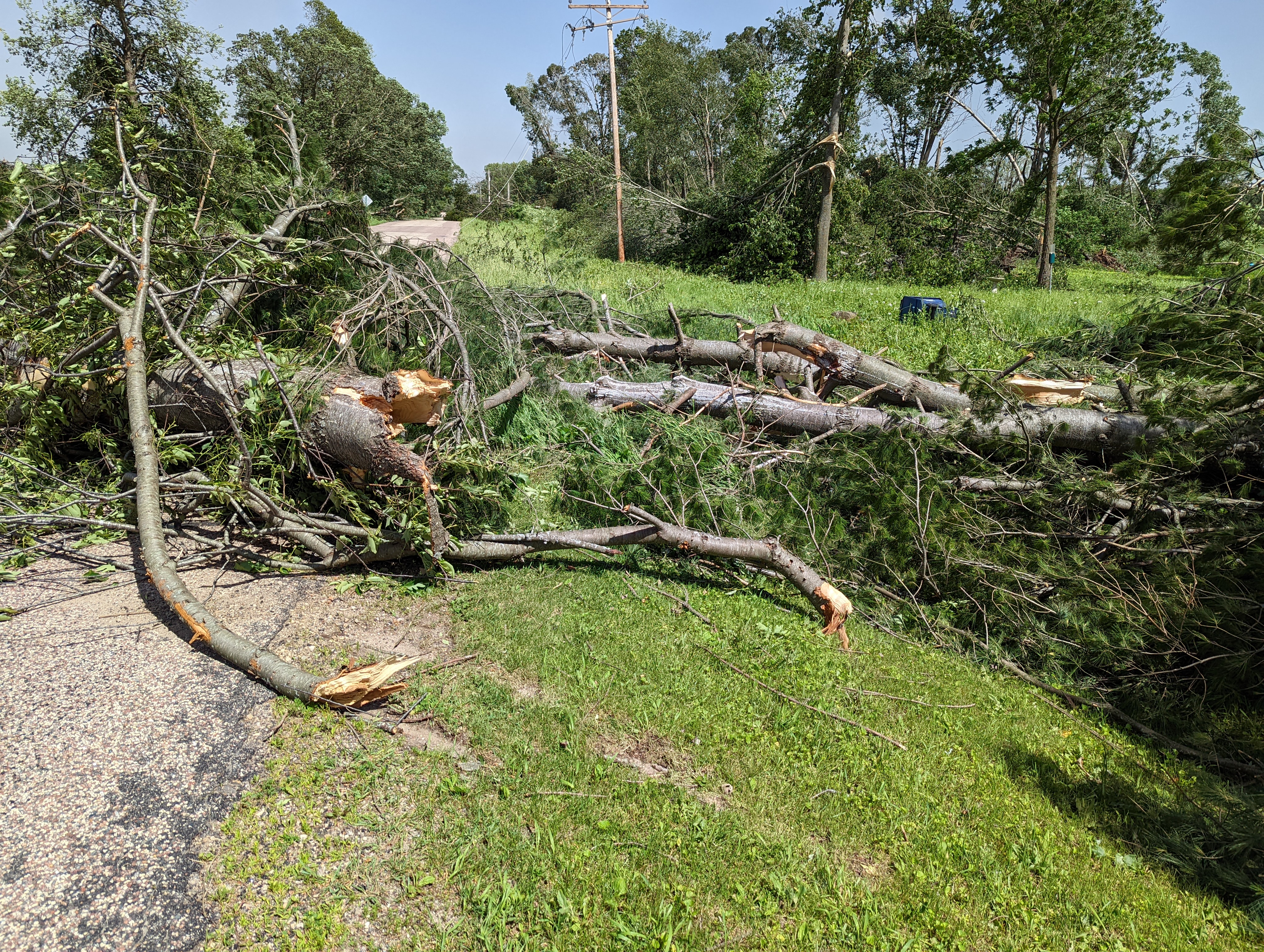
 East of Black Creek (central Outagamie Co.) |
 East of Black Creek (central Outagamie Co.) |
 East of Black Creek (central Outagamie Co.) |
 East of Black Creek (central Outagamie Co.) |
 |
Media use of NWS Web News Stories is encouraged! Please acknowledge the NWS as the source of any news information accessed from this site. |
|