Overview
|
A series of heavy precipitation events resulted in record setting and historic flooding on several rivers across northeast WI from mid to late April 2026. The total precipitation for the month of April in Green Bay was 8.56 inches, which exceeded the previous record for the month by over 2 inches (6.47 inches set in 1929). Similarly, April's monthly precipitation at Wausau of 8.74 inches broke the previous record by over 2.5 inches (6.06 inches set in 1954). After two moisture laden ice storms impacted the region at the start of the month, a volatile period of thunderstorms with heavy rain occurred from Sunday, April 12 through Tuesday, April 14. Flash flooding occurred late Monday night (April 13) through Tuesday evening (April 14). Areas hardest hit included the Suamico and Green Bay areas, where water rescues occurred near the Suamico River on the morning of April 14, and in the Green Bay metro during the evening of April 14. Due to the extreme heavy rain of 4-6 inches noted over portions of Waupaca and Shawano counties, multiple dams experienced overtopping, with some at risk of failing. Several Flash Flood Watches and Warnings were issued for the potential dam failures Tuesday, April 14 into Wednesday, April 15. The heavy rainfall especially impacted the Wolf River basin, leading to record setting flooding for the Wolf River at Shiocton and the Wolf River at New London. Record flooding also occurred on other rivers over northeast WI, including the Embarrass River near Embarrass and the Peshtigo River near Porterfield. A record high level was also set on the Wolf River near Lake Poygan. Major flooding was also observed on the Menominee River at McAllister as it reached its second highest level on record. In total, 47 river flood warnings were issued from late March through early May. Some river flood warnings were in effect for nearly one month! The river flooding resulted in tremendous disruptions to daily life for those living along and near the Wolf River and Embarrass River. Evacuations occurred in the towns of Shiocton and New London for multiple days. Power and gas was shutoff in these areas as flood waters impacted many homes and businesses. The peak of the flooding along the Wolf River occurred from April 16 through April 21. Flooding then moved downstream on the Wolf River, impacting the Fremont and Winneconne areas, as well as areas along Lake Poygan. Eventually the higher flows on the Wolf River and the lower Fox River resulted in the rising levels on Lake Winnebago, with prolonged minor flooding noted on the western and northern side of Lake Winnebago in Oshkosh, Neenah, and Menasha. |
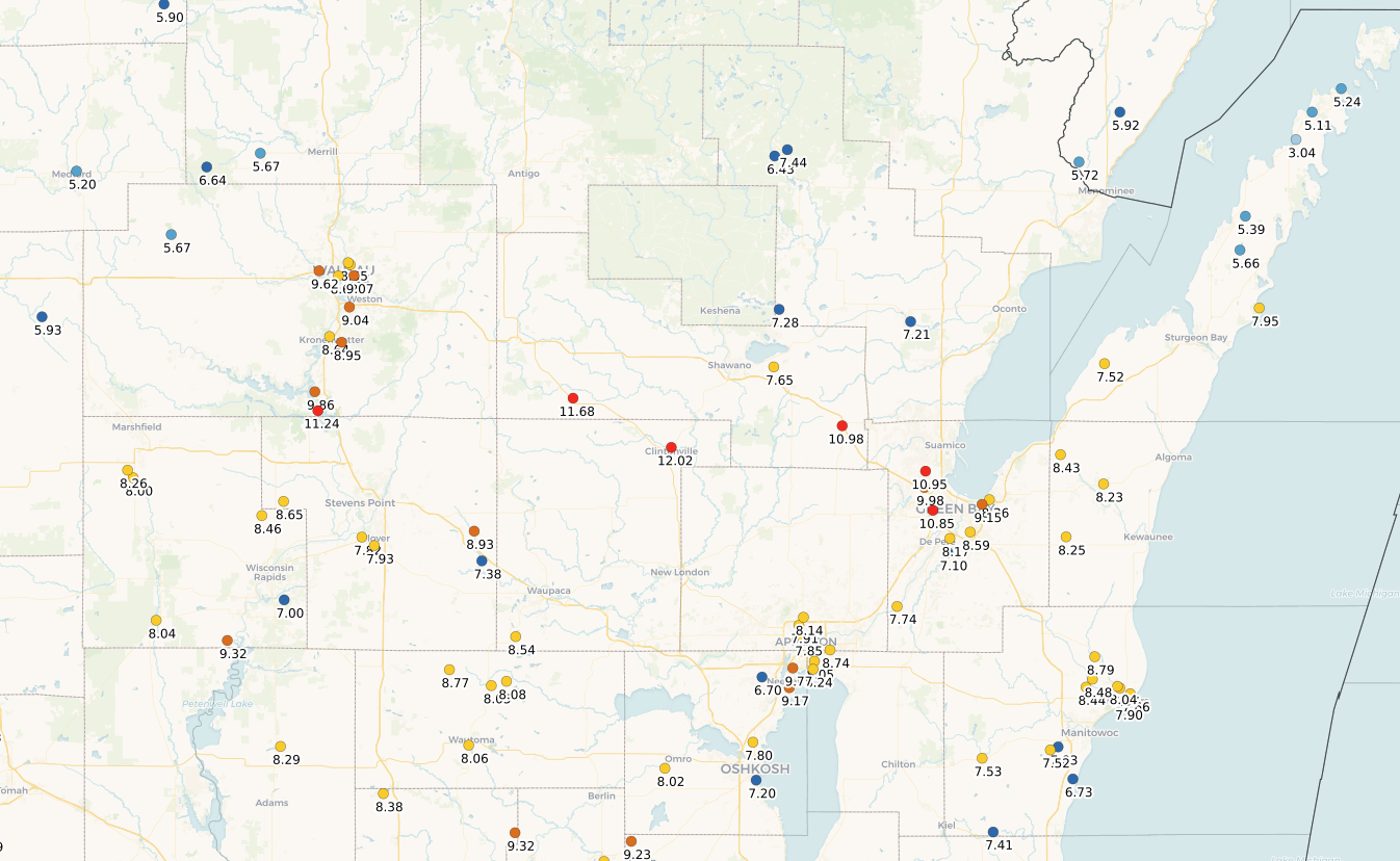
April 2026 Total Precipitation
|
 |
.png) |
|
| Observed Precipitation for April 2026 (CoCoRaHS) | Observed Precipitation for April 12th through 15th (CoCoRaHS) |
Wolf River
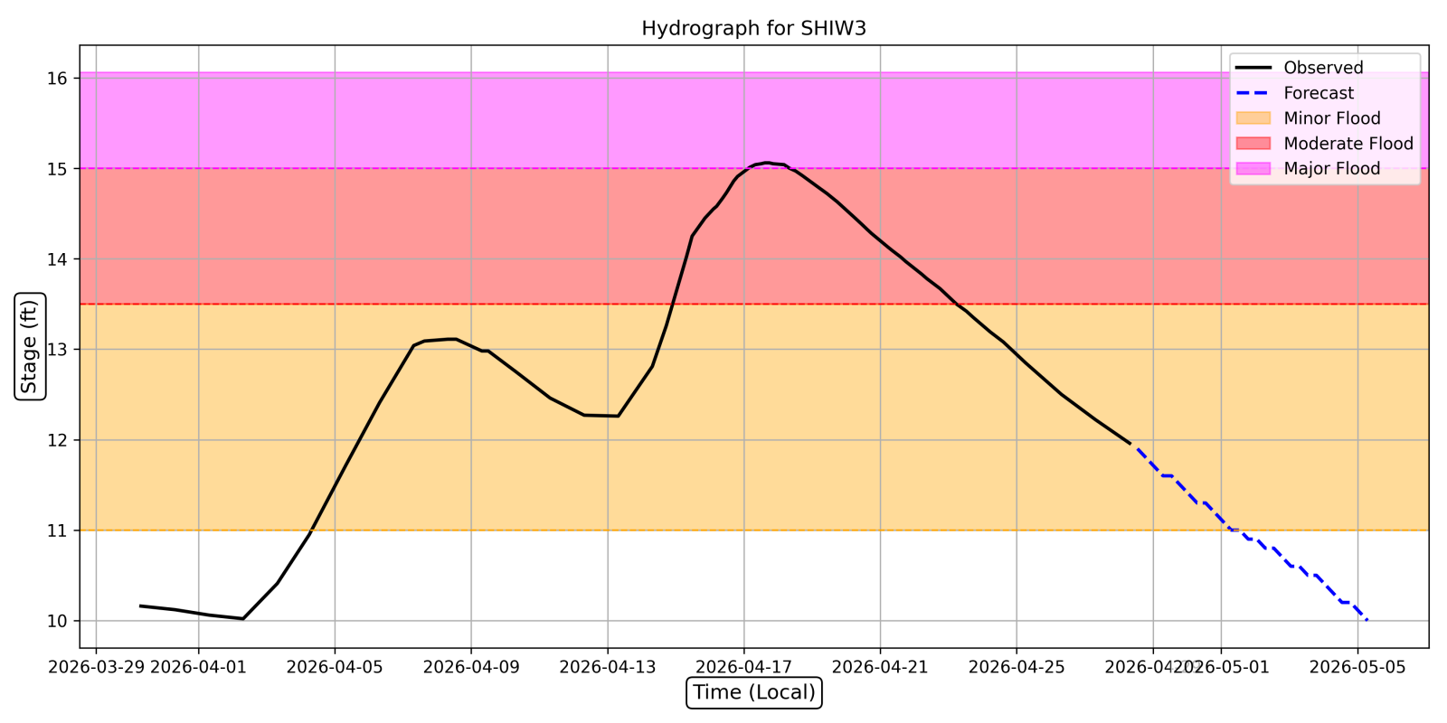
Wolf River at Shiocton (SHIW3): New Record: 15.06 ft (preliminary). Previous record: 14.1 ft (4/1/1922). Time in record: 1130 am 4/17 through 825 am 4/21. The NWS extends a huge thanks to the observers at the Shiocton Waste Water Treatment plant who took additional observations during the time of peak flooding. This observation is a manual observation typically taken only once per day.
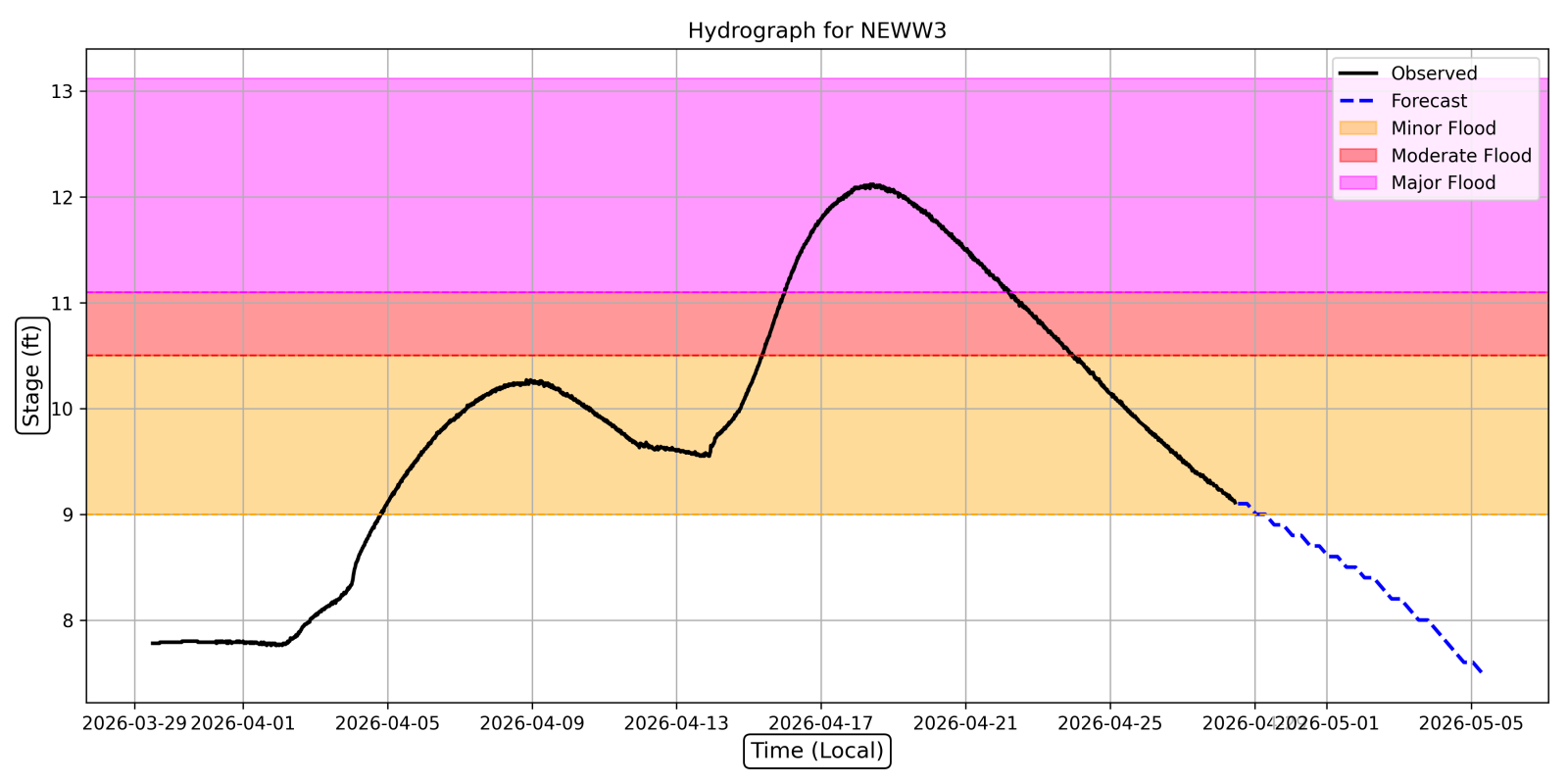
Wolf River at New London (NEWW3): New Record: 12.12 ft (preliminary). Previous record 11.83 ft (4/3/1979). Time in record: 230 am 4/17 through 1215 am 4/20.
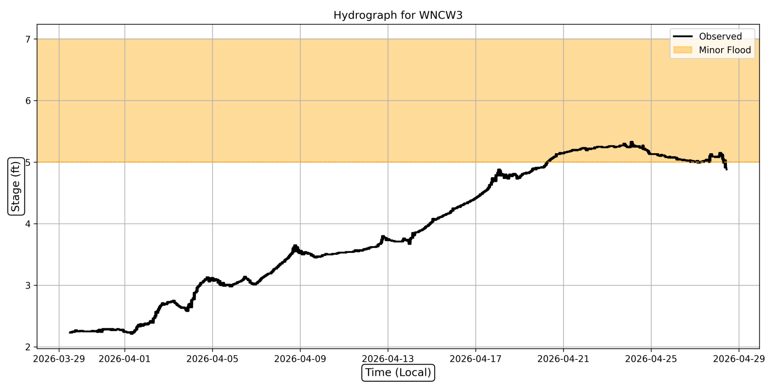
Wolf River near Lake Poygan (WNCW3): New Record of 5.33 ft (preliminary) set at 130 am to 230 am on April 24th. Previous record 4.85 ft set on 6/17/2004.
Hydrographs
 |
 |
 |
|
| Wolf River at Shiocton (SHIW3) | Wolf River at New London (NEWW3) | Wolf River near Lake Poygan (WNCW3) |
Photos
 |
 |
 |
|
| 4/17/26 Flooding reaches its peak in Shiocton (Outagamie EM) | 4/18/26 Downtown New London (Waupaca EM) | 4/17/26 Flooding of Shiocton Airport (Outagamie EM) |
Menominee River
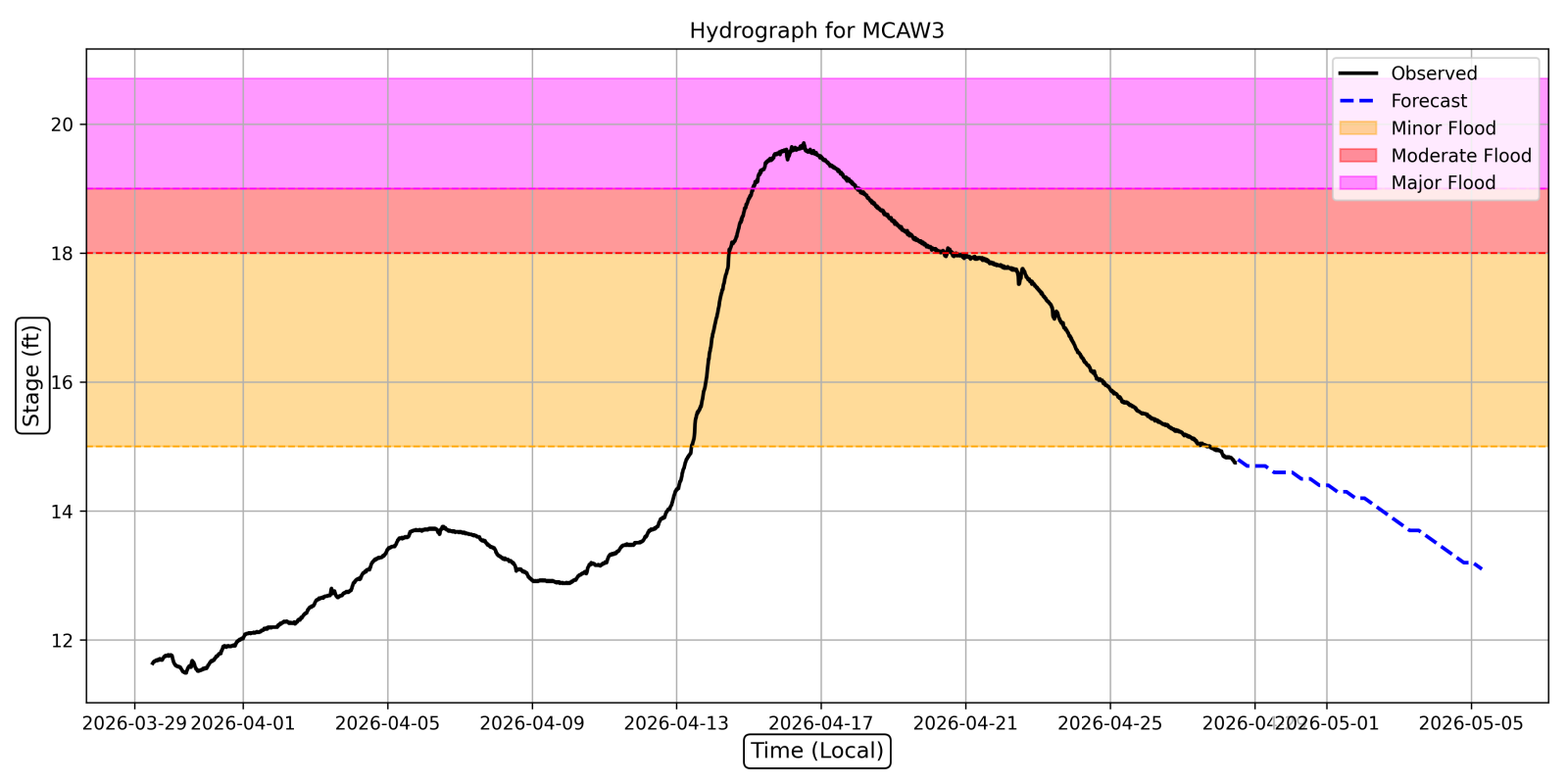
Menominee River near McAllister (MCAW3): Reached Major Flood stage from 3am on April 15th through 12am on April 18th. The crest of 19.71 ft was the second highest on record (20.00 ft on 5/9/1960).
Menominee River at White Rapids (BANM4): Reached the highest stage on record (preliminary) of 15.19 ft at 630pm on April 15th. The previous record high mark at this site was 15.05 ft on 4/18/2023.
Hydrographs
 |
|||
| Menominee River near McAllister (MCAW3) |
Photos
 |
 |
||
| 4/15/26 Menominee River near Bear Point Landing (6mi east of Wausaukee, WI) Courtesy Patrick Klein. | 4/18/26 Hattie Street Dam. Courtesy Jordan Forslund. |
Wisconsin River
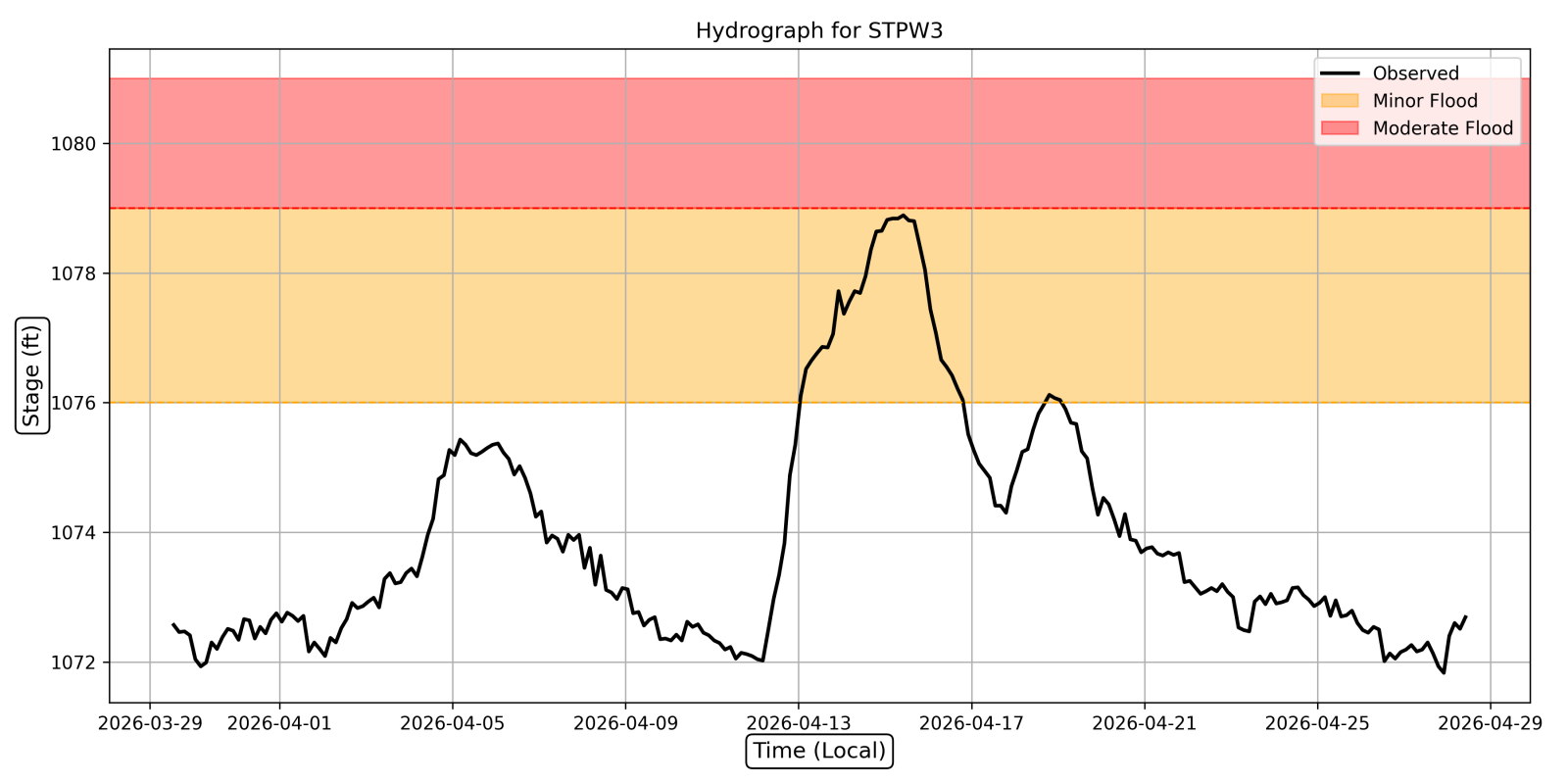
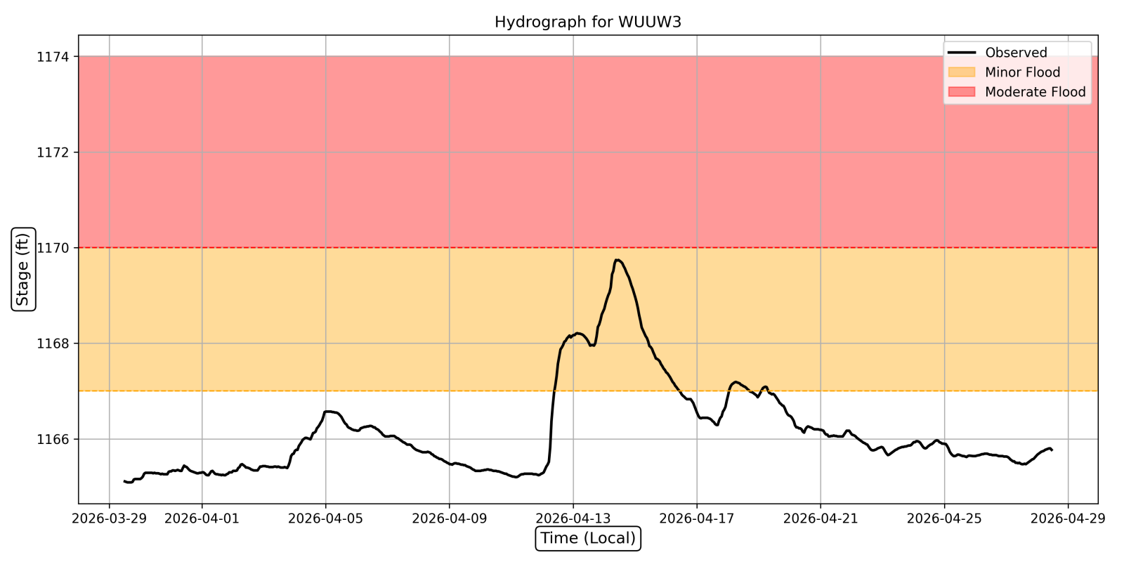
Though levels were high on the Wisconsin River, no site reached Major Flood Stage or set records.
Hydrographs
 |
 |
||
| Wisconsin River below Stevens Point Dam (STPW3) | Wisconsin River below Wausau Dam (WUUW3) |
Photos
 |
 |
||
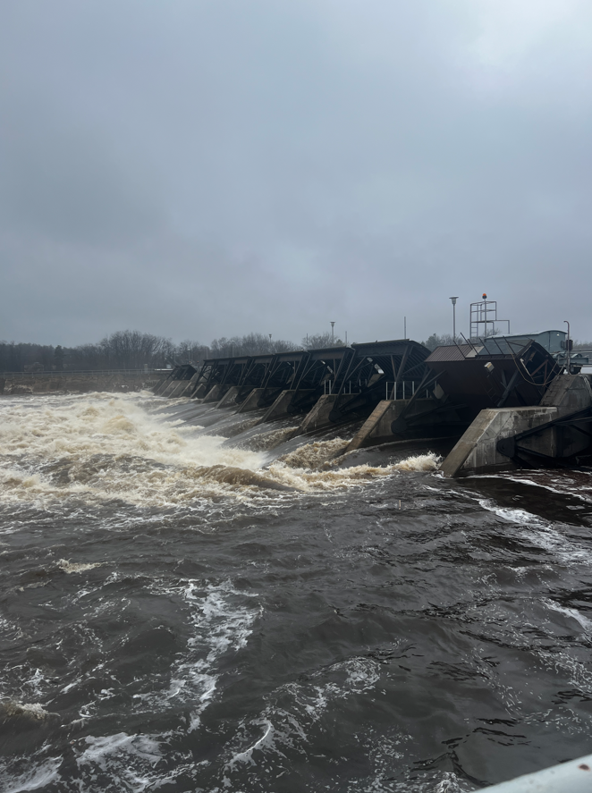
| 15April 2026 DuBay Dam - 45,000 cfs. Courtesy Consolidated Water Power Co. | 15April 2026 Stevens Point Dam - 51,772 cfs. Courtesy Consolidated Water Power Co. |
Other Rivers
The following are additional rivers that set records (preliminarily) during April 2026.
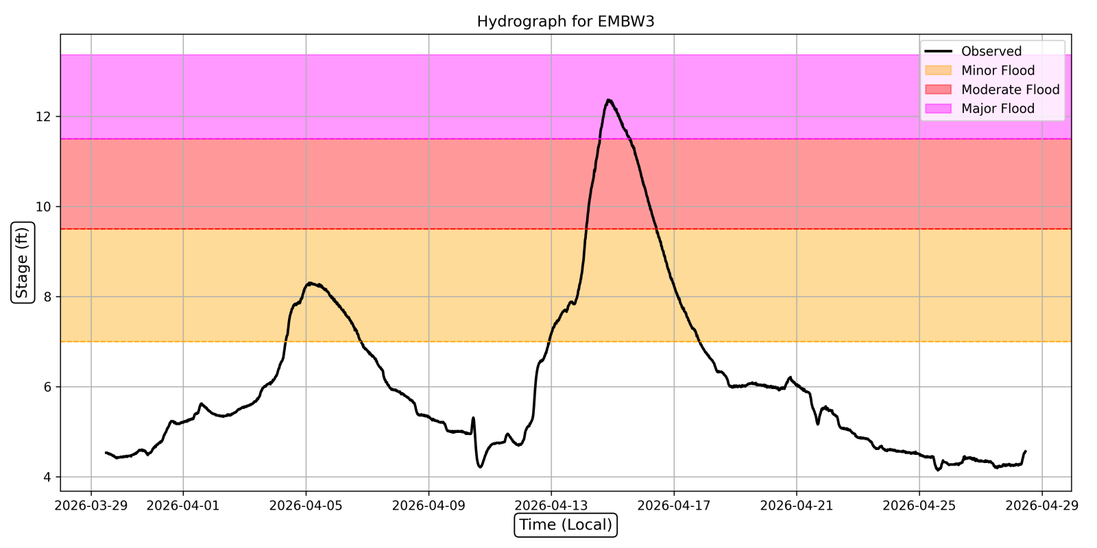
Embarrass River near Embarrass (EMBW3): The site reached Major Flood stage from 215 pm on April 14th through 1 pm on April 15th. During this time the river crested at a record level (preliminary) of 12.36 ft at 815 pm on April 14th. This broke the previous record of 12.13 ft set on 4/12/1965.
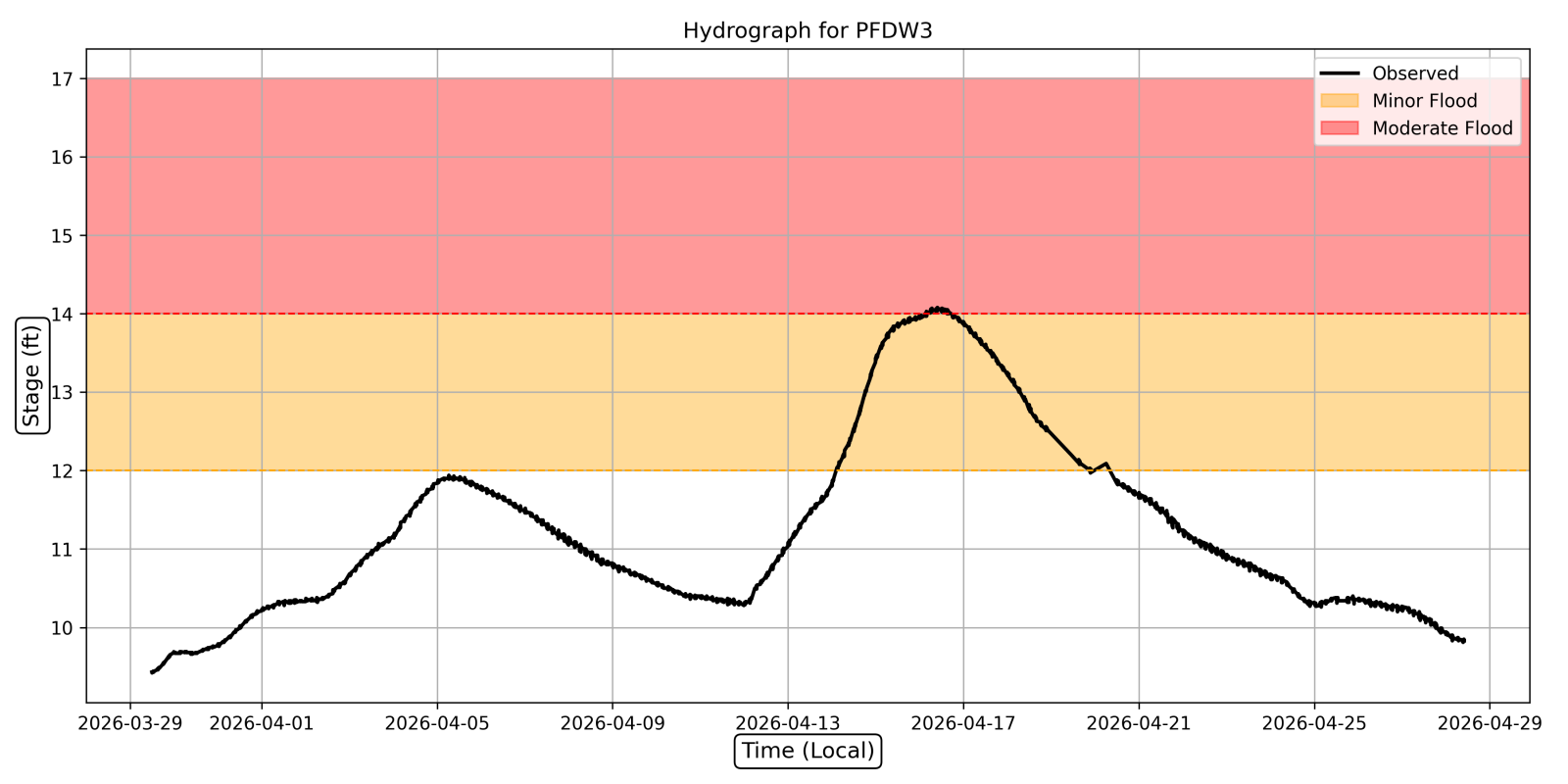
Peshtigo River near Porterfield (PFDW3): The site crested at a stage of 14.08 ft (preliminary) from 9 to 10 am on April 16th. This broke the previous record of 13.87 ft set on 3/30/2004.
Hydrographs
 |
 |
||
| Embarrass River near Embarrass (EMBW3) | Peshtigo River near Porterfield (PFDW3) |
 |
.png) |
|
| MRMS estimated 24 hour precipitation ending at 7 am 4/14/26. Swath of very heavy rain (with localized amounts over 6 inches) impacted Shawano, Waupaca into northern Brown counties. | Recurrence intervals for rainfall for a point along the Shawano and Waupaca county line (red bullseye in image to the left). Data indicates that 24 hour rainfall in this swath was solidly in the 50 year to 200 year frequency (e.g. a 1/50 to 1/200 chance of seeing this in any given year). https://hdsc.nws.noaa.gov/pfds/ |
.
 |
Media use of NWS Web News Stories is encouraged! Please acknowledge the NWS as the source of any news information accessed from this site. |
|


.png)
.png)