Winter Storm Part I - Summary...& Expectations for Part II
A major and complex winter storm will continue to impact the entire forecast area through Thursday with bouts of heavy snow, very low visibilities and blowing snow creating very hazardous travel.
Part 1 of this ongoing storm has already impacted much of central and east-central Wisconsin Tuesday night dumping 4 to 6 inches of snow (Figure 1). This initial snowfall was associated with a band of moderate snow that drifted north across the forecast area overnight (Figure 2). Note that the area of moderate snowfall (green colors in the radar enhancement in Figure 2) was quite narrow! This initial snow band quickly weakened as the upper-level forcing that contributed to the formation of this band moved off to the east of Wisconsin. Also note that near the end of the radar loop, additional bands of snow were forming over parts of southern Wisconsin by late Wednesday morning. These bands of precipitation represent the beginning of what was to come for later Wednesday afternoon, into Thursday.
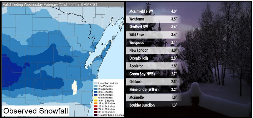
Figure 1 (above) - Observed Snowfall Totals For Part I Through 6 am Wednesday February 22, 2023
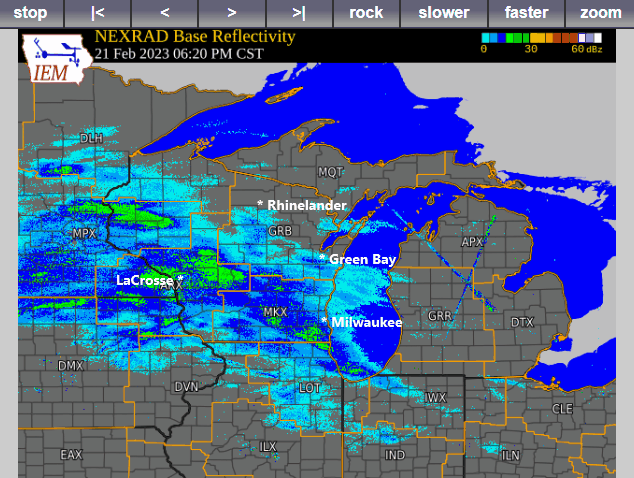
Figure 2 (above) - Composite WSR-88D Radar Animation from 630 pm Tuesday through 910 am Wednesday
Figure 3A (below) is a GOES-16 water vapor satellite animation that illustrates how expansive this developing winter storm was from Tuesday night into Wednesday morning. Early in the animation, note the approximate W-E orientated clouds streaming across Wisconsin. These clouds were associated with the band of light to moderate snow that impacted the forecast area Tuesday night. By the end of the animation, we see that these clouds quickly dissipated. However, that was just the beginning (Part I) of a much larger and complex storm system that continued to develop across the Rockies, Central Plains, and over the middle Mississippi Valley.
Figure 3B (below) highlights the key components of this storm system that will act in concert to produce more widespread heavy snow across all of Central, North-central and Northeast Wisconsin from Wednesday afternoon through Thursday afternoon. The expansive cloud mass over the central United States in Figure 3B represents where there is deep moisture, moderate precipitation and unstable air already in place. This large area of moisture and unstable air will interact with two upstream upper-level disturbances. Disturbance 1 (Figure 3B) helped to further organize and enhance a large band of heavy precipitation later Wednesday afternoon into late Wednesday evening over Wisconsin. Figure 4 is a short GOES-16 enhanced visible animation showing the approaching disturbance (#1) over western Nebraska and the western Dakotas, poised just upstream of the area of deep moisture and instability just to the east. As this disturbance approached Wisconsin late Wednesday, it helped to push heavy precipitation (in the form of heavy snow perhaps mixed with some sleet) northward into the forecast area. Snowfall rates in the heaviest snow bands Wednesday evening were 1 or perhaps 2 inches per hour! In addition, NE winds increased as the heavy snow fell that caused visibilities to reduce to less than 1/4 mile, contributing to blizzard-like conditions at times over open areas in parts of central and east-central Wisconsin. Then, the second upper-level disturbance #2 (Figure 3B) will approach the area Thursday morning that will once again help to organize and enhance the snowfall. Latest model guidance suggests that the heaviest snowfall (highest snowfall rates) on Thursday will most likely impact central and northern Wisconsin.
As this is a complex winter storm, the exact evolution of this storm may still change, so please stay tuned to later forecast updates from NWS Green Bay.
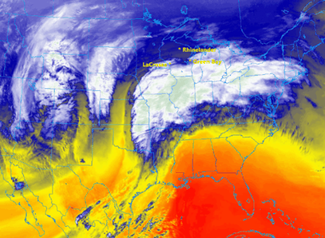
Figure 3A (above) - GOES 16 Water Vaper Animation from approximately 6 pm Tuesday Evening through 9 am Wednesday morning.
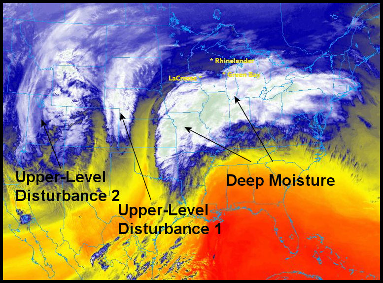
Figure 3B (above) - Components of the Complex Winter Storm System
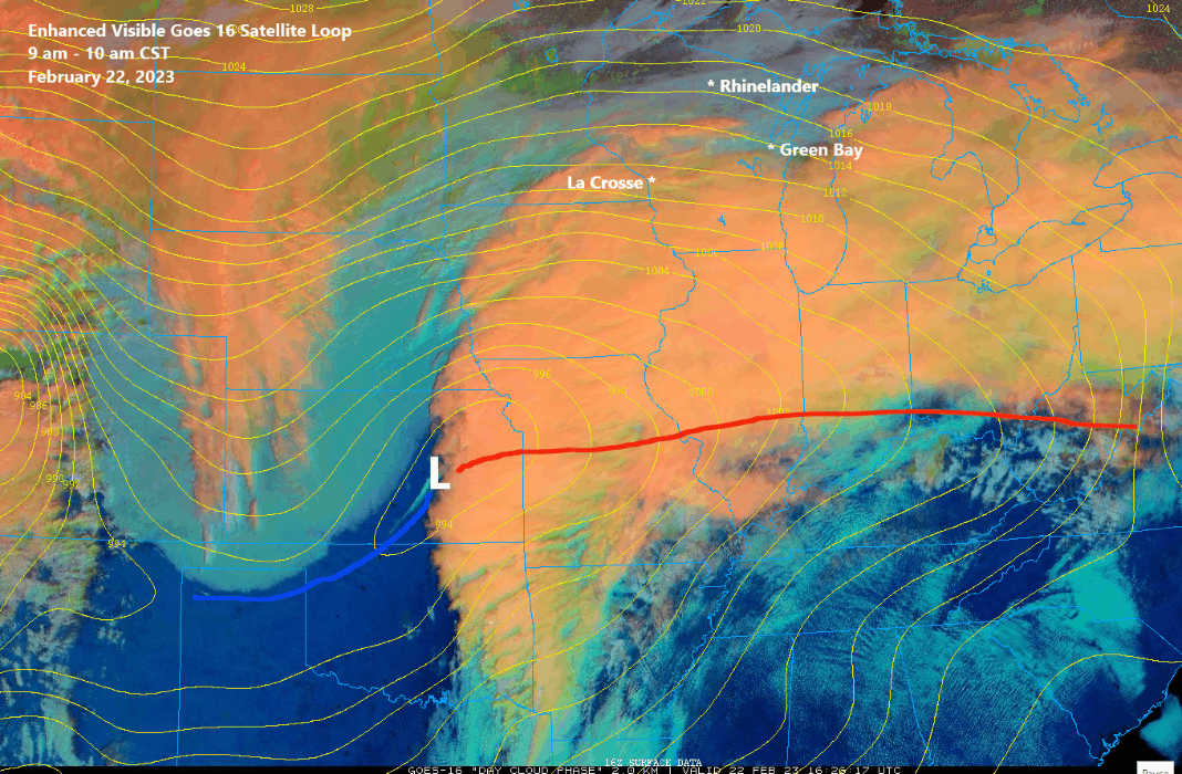
Figure 4 (above) - Goes-16 Enhanced Visible Animation from 9 am to 1015 am CST Wednesday February 22. The orange-colored cloud shield denotes the higher and thicker clouds associated with moderate precipitation expanding northward toward Wisconsin. The upper-level disturbance #1 is the cloud feature over western Nebraska and the Dakotas as of 1030 am Wednesday morning.
Figure 5 (above) - Latest snowfall accumulation forecast for Part 2. Note this snowfall forecast may change with later forecasts so stay tuned!
Be sure to plan for very difficult travel conditions through Thursday. Travel is not recommended tonight.

