Living Through Hurricane Harvey
By Sean Luchs, Meteorologist NWS Houston
|
For me, the story of working Hurricane Harvey began in Nashville, Tennessee. I was in Nashville to visit my brother and see the solar eclipse. When I left the office on my last shift, what would become Harvey, was just a disorganized system with medium potential for tropical development. Some of the forecast model runs suggested the storm could drift up in our direction, but most guidance indicated upper-level high pressure ridging would be strong enough to push it into Mexico. Although I joked about a hurricane ruining my vacation, I was a bit nervous. Earlier in the season, models were confident that Tropical Storm Cindy would impact Mexico, when it actually ended up making landfall on the Texas/Louisiana border. I tried to focus on my vacation, but checked into the office occasionally to get updates. Tropical Storm Harvey had formed, moved through the Lesser Antilles, and dissipated in the “hurricane graveyard” of the eastern Caribbean. However , it was still being watched, and on Tuesday a certain tweet in particular from my office caught my eye: “The National Hurricane Center now put regeneration of Harvey at 100%”, and the region to watch for possible impact was Texas. I told my brother that I would be getting a call from the office soon. Not much later, I received a text message asking when I would be back in town. Fortunately, I was already set to fly home the next evening. |
|
|
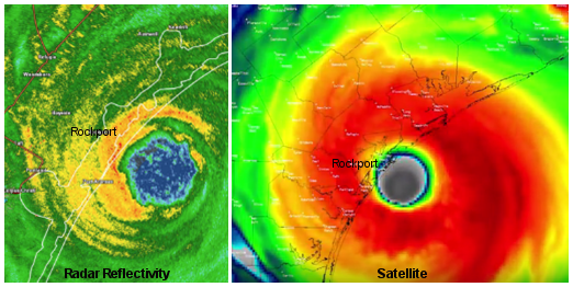
I was allowed to keep my days off on Thursday and Friday to prepare my house and family. Though stores were busy, folks were staying calm. I kept as close an eye on developments as I could, and the rapidly intensifying storm was now forecast to be a major hurricane at landfall near Corpus Christi – the first for the US coast in 12 years. The lack of forecast steering winds after the storm reached Texas was particularly concerning for me as this could result in lots of rain.Big rainfall totals were forecast, and the numbers rose with each new forecast. In fact, the Weather Prediction Center had to start adding new shades of color to their rainfall forecasts. If these amounts of rain fell over populated areas, the flooding would be life-threatening. Though I was working Saturday morning, I stayed up late to watch the landfall of the storm near Rockport, Texas. Our neighbors in the Corpus Christi office were doing a great job, and I went to bed knowing it was our turn tomorrow.It was a hard rain driving into the office Saturday morning. I met our newest meteorologist for the first time - what a time to have a first week in the agency! Although busy, the day shift felt fairly routine. I focused on my role, which was to prepare all of the forecast parameters and products that are only made when threatened by a tropical cyclone. There was a lot to accomplish on a very tight time frame, but I settled into a groove. However, it was also becoming apparent that there would be a lot of rain overnight. When my relief for the night shift arrived, I apologized that her shift would be much busier than mine. I was on the fence whether or not to stay at the office overnight, but decided that if I could squeeze one last night in my own bed before switching to a cot in the conference room, I would take it. That decision will probably not go down as one of my wisest. At home, I couldn’t get to sleep as the rain picked up. I watched social media and watched data roll in, focusing on the rain gauge from the Harris County Flood Control District’s network nearest my house. Outside, the sound of rain picked up more, and more. A band of heavy rain slowed to a crawl as it reached the area. The numbers piled up, some were mind-boggling with 6 inches of rain in an hour and 9.9 inches of rain in 90 minutes! My phone began screaming with alerts- A flash flood warning, a flash flood emergency, and then Tornado Warnings. At some point it finally occurred to me to look out the window to the street. It was hard to see much as it was raining so hard the streetlights were barely visible. There was lightning – a lot of lightning for a hurricane. The thing that captured my attention was a small rubber ball. I had no idea where it came from. Like a fishing bobber, it floated on top of a rising stream of water, and marked how high the water had come up in my front yard.
Fortunately for me, I took very little water into my house. After a couple hours, the water began to recede. Although the water never covered the whole floor, some floors were ruined, as well as baseboards and the lowest portion of the drywall along the exterior walls and garage. Many others would not be so lucky. I would learn of people being rescued by boats, some off of their roofs. Emergency Management offices were telling people to bring an axe to break through to the roof if they chose to enter their attics. I grabbed a couple hours to nap, and waited for the water to recede enough for me to get into the office. While I waited, I could see and hear Coast Guard helicopters constantly flying over my house in their rescue efforts. Eventually the water came down enough that a co-worker was able to pick me up in a truck. I was only ten hours late for my shift! That night, the rain machine got started up again. In addition to the tropical forecast products, I maintained the flash flood emergencies and warnings covering our entire forecast area. It rained a lot, but nothing to match the previous night. As I briefed the incoming shift in the morning, I said something that instantly summed up how unusual our situation was: “It was a slow night - we only had 4-10 inches across the area.” I headed home to grab another nap, and pack a bag. Another night of heavier rain was expected, and I had to prepare to be in the office for a while. It was a wise choice, as rain started and my route was cut off shortly after I got back into the office. While I worked, my wife sent updates on the house. Water would rise into the yard again, but thankfully stay out of the house. A defining feature of the storm was its longevity. Two of Houston’s five rainiest days now belong to Harvey, and other days surely aren’t that much farther down the list. Rain continued through the week, but the heaviest portions moved just out of our area to the east. This allowed an uneven start to recovery. As search and rescue (SAR) efforts continued in some areas and while near overloaded reservoirs were still rising, recovery work began in other areas where things were drying out. On Tuesday I began preparing specialized forecasts for SAR groups addressing potential Hazmat situations and concerns for levee breaks. The highest profile incident was at the Arkema chemical plant, where the loss of power had allowed for chemicals to become unstable and potentially explosive. We would spend several days providing specialized forecasts as that situation played out with multiple containers burning. |
|
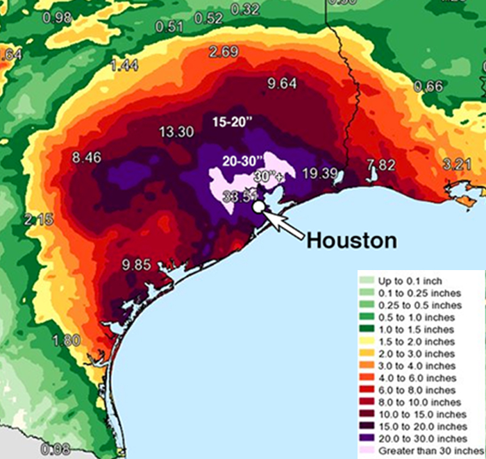
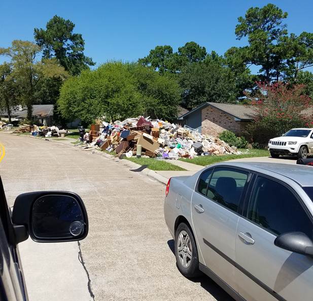
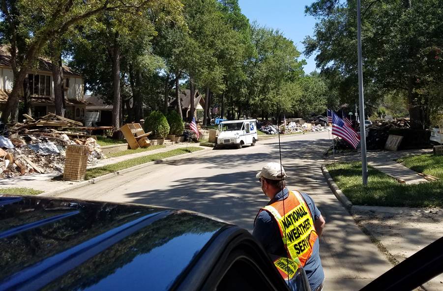
As the week dragged on, the rain totals also continued to increase. I had the dubious “honor” of writing the product declaring that we had rainfall reports that exceeded the Continental US record for total rainfall in a tropical event. Looking back, Tropical Storm Allison in June 2001, had been the benchmark for Houston’s rainiest month. After Harvey, August 2017 had more than doubled that record! When rainfall totals were combined with population data, it was found that 6.5 million people saw at least 20 inches of rain from the storm (see rainfall map on right). Every watershed in our area went into major flood territory, and most saw records set. Perhaps the most surprising fact I learned was NASA determined that there was so much floodwater over Houston that the area sank nearly an inch from the weight of the water alone. In the weeks that followed, things slowly began to return to normal, although unevenly. We went out on surveys for damage and high water marks the week after the storm exited. Some water marks were found 8-10 feet above ground. Most schools were returning to session. After his first day of school ever, my son finally returned for his second day of class after two weeks. After a few weeks, the last of the flood waters left streets and homes near Addicks and Barker reservoirs. Along with 155,000 other residence in just Harris and Galveston counties alone, I brought my debris out to pile on the curb (see pictures below). It took more than a month for mine to disappear. Many debris piles remain. |
|
|
Some people have had their home damage and repaired, others are still in the process. Many, like my home, haven’t been touched yet. Some never will. We mourn the loss of 53 in our forecast area, but also get to hear stories from our emergency management partners of how many were saved. Work related to Harvey still continues, as we evaluate the work we did, what went well, and how we can improve for next time. We’re still evaluating rainfall reports, to determine the validity of several reports over 50 inches. For now, the highest rainfall total is 60.58 inches, but two more totals over 61 inches are still being validated. Hurricane season marched on with Hurricanes Irma, Maria, and Nate all striking the United States since Harvey. Fortunately for us, but unfortunately for others, we have been left alone. A couple of forecasters from our office have gone to Miami to provide backup services for the San Juan, Puerto Rico office after Maria devastated that island and the US Virgin Islands. Eventually, we’ll return to some sense of normal, but some things will take years and we’ll be looking ahead to the next one. Even before Harvey, the Houston area has seen multiple significant (100-year or worse) flooding events. It’s only a matter of time until the next one. When it comes, we’ll be here to provide the forecasts and warning information needed to help our neighbors stay safe.
Here is a list of websites with additional information on Hurricane Harvey: http://www.weather.gov/hgx/hurricaneharvey |


.png)
 For the next few hours, I was obsessed with that ball and trying to extrapolate 30-minute, 15-minute, 5-minute rain rates. Water came into my garage as the rain kept falling. The weather alerts continued to come through my phone. Eventually, the water reached the foundation of the house. The rain was slowing some as the band weakened, but it still kept falling. The water reached the rest of the house, and suddenly every towel and blanket in the house was bundled in front of the doors. As the water rose just to the top of the foundation, the rain stopped. The water fell half an inch, but the rain began again and it rose. This continued for some time, and I started to hope that as long as the lingering cells were light enough, I would be okay. There was to be no such luck, as a cell with heavy rain finally pushed the water level over the top of the foundation, and water began seeping through weep holes and into the house.