April 2-3, 2024 Damaging Winter Storm
|
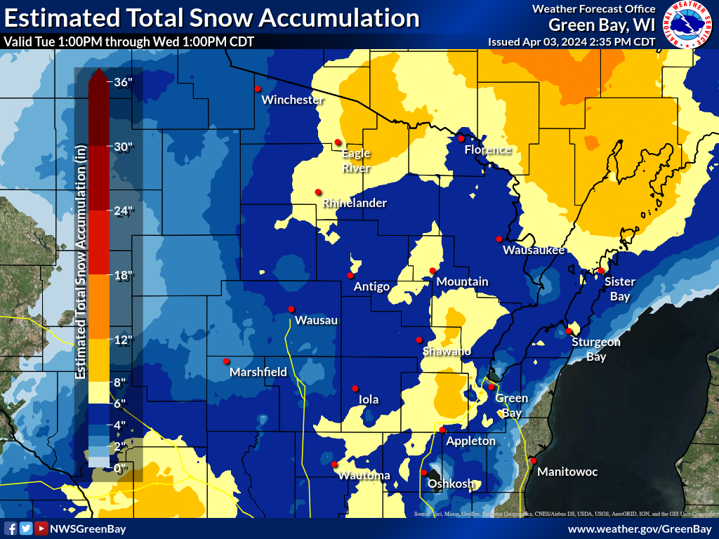
Event Overview An rapidly intensifying area of low pressure moving across Illinois to southern Lake Michigan on the afternoon of April 2 brought copious amounts of rain and heavy wet snow, damaging winds, and thunderstorms. The storm left over 100,000 people across the state without power during the height of the storm. Rain and snow developed during the morning of April 2, mainly south of Highway 29, which continued into the early afternoon. The rain was mainly confined to the Fox Valley and lake shore. With air and road temperatures above freezing, little snow accumulation was noted through the mid-afternoon hours. As the low pressure system moved northeast and strengthened, a band of heavier precipitation moved into the Fox Valley and lake shore by the late afternoon, resulting in a change over to heavy wet snow with rapidly increasing snowfall rates. As a result, travel conditions deteriorated quickly around sunset due to the cooling temperatures, high snowfall rates of 1 to 2 inches per hour and very low visibilities down to 1/4 mile at times. Thunderstorms were also reported across northeast Wisconsin, especially in the Green Bay Metro area where vivid cloud to ground lightning strikes were observed during the evening. Strong NNE winds also developed during the late afternoon on April 2, and continued through the evening. The highest peak gust of 56 mph was recorded at the Green Bay Airport. Most locations recorded wind gusts of 30 to 50 mph. The combination of the strong winds and concrete-type snow led to numerous reports of trees and power lines down across northeast Wisconsin. At the height of the storm, over 100,000 people across the state (mostly in northeast Wisconsin) were without power. Also, the strong northeast winds created just over a 2 foot rise in water levels at the mouth of the Bay of Green Bay. The storm brought liquid precipitation (rain & snow water equivalent) totals of 1 to 2.50 inches across northeast Wisconsin, including the Fox Valley and lakeshore, with lower totals to the north and west. Snowfall totals (see map above right) over 6 inches were noted across portions of north-central and far northeast Wisconsin, southward into the Fox Valley, and as far west as Wautoma and Plover. If temperatures were just a degree or two colder, snowfall amounts may have been substantially higher!
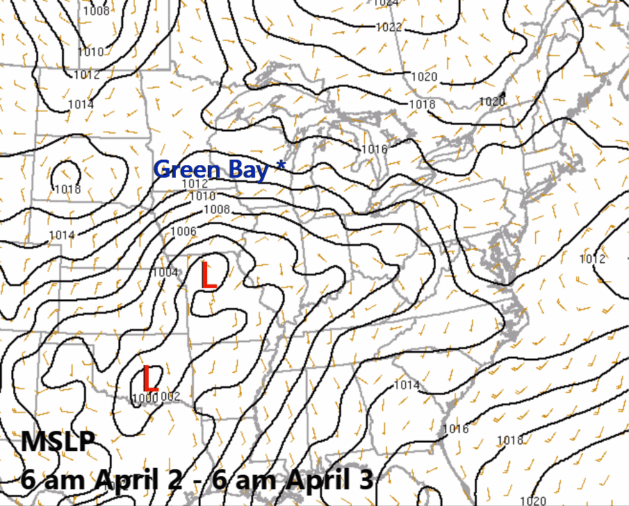
RAP Surface Analysis - Wind barbs and mean sea level pressure (MSLP). The track of the low pressure system is denoted by the "L" on the analysis.
Please see tabs below for more information. |
(Note: Estimated total snow accumulation map above may not reflect all snowfall reports, as it was generated based on reports received.)
RAP 500mb Analysis - Wind barbs, wind speed (shaded), and heights (solid black lines). White "J" denotes the approximate location of the strong jet maximum. |
Snow Reports
Preliminary Local Storm Report...Summary
National Weather Service Green Bay WI
225 PM CDT Wed Apr 3 2024
..TIME... ...EVENT... ...CITY LOCATION... ...LAT.LON...
..DATE... ....MAG.... ..COUNTY LOCATION..ST.. ...SOURCE....
..REMARKS..
0900 AM Snow 4 N Phelps 46.12N 89.08W
04/03/2024 E11.0 Inch Vilas WI CO-OP Observer
CO-OP Observer station LVDW3 Phelps 4.2 N.
Mentioned in windy conditions, snow will
blow over the gage and will not make an
accurate catch. Reading is an estimate.
1000 PM Snow Pulcifer 44.84N 88.34W
04/02/2024 M9.5 Inch Shawano WI Public
0646 AM Snow 4 E Eagle River 45.91N 89.17W
04/03/2024 M8.8 Inch Vilas WI CO-OP Observer
1020 PM Snow Greenville 44.29N 88.53W
04/02/2024 M8.0 Inch Outagamie WI Public
0730 AM Snow 3 SW Rhinelander 45.60N 89.45W
04/03/2024 M8.0 Inch Oneida WI CO-OP Observer
CO-OP Observer station RHIW3 Rhinelander 2
SW.
0820 AM Snow 4 ESE Mc Naughton 45.70N 89.48W
04/03/2024 M8.0 Inch Oneida WI Cocorahs
Cocorahs station WI-ON-14 Rhinelander 5.5
NW.
0500 AM Snow 2 WNW Appleton 44.28N 88.44W
04/03/2024 M7.8 Inch Outagamie WI CO-OP Observer
CO-OP Observer station APPW3 Appleton.
0900 PM Snow 1 S Omro 44.02N 88.75W
04/02/2024 M7.4 Inch Winnebago WI Public
Over 7in of snow currently with heavy snow
still falling- power is out.
0750 PM Snow Greenville 44.29N 88.53W
04/02/2024 M7.2 Inch Outagamie WI Public
0630 AM Snow 2 SE New London 44.36N 88.72W
04/03/2024 M7.2 Inch Outagamie WI CO-OP Observer
CO-OP Observer station NONW3 New London 2
SE.
1000 PM Snow 1 NNE High Cliff State 44.17N 88.27W
04/02/2024 E7.0 Inch Calumet WI Public
0600 AM Snow 7 NNE Hamburg 45.18N 89.85W
04/03/2024 M7.0 Inch Lincoln WI Cocorahs
Cocorahs station WI-LN-2 Merrill 7 W.
0600 AM Snow 7 NNE Hamburg 45.18N 89.85W
04/03/2024 M7.0 Inch Lincoln WI CO-OP Observer
CO-OP Observer station MLLW3 Merrill 8 W.
0600 AM Snow 2 S Sugar Bush 44.45N 88.73W
04/03/2024 M7.0 Inch Outagamie WI Cocorahs
Cocorahs station WI-OG-18 New London 4.1 N.
0700 AM Snow 4 WNW Oconto 44.89N 87.95W
04/03/2024 M7.0 Inch Oconto WI CO-OP Observer
CO-OP Observer station OCNW3 Oconto 4 W.
1106 AM Snow 2.85 N Rhinelander 45.67N 89.41W
04/03/2024 M7.0 Inch Oneida WI Trained Spotter
0630 AM Snow 1 W Silver Lake 44.04N 89.24W
04/03/2024 M6.9 Inch Waushara WI CO-OP Observer
CO-OP Observer station WAOW3 Wautoma 3 SE.
0600 AM Snow 1 N Waupaca 44.35N 89.06W
04/03/2024 M6.8 Inch Waupaca WI CO-OP Observer
CO-OP Observer station WWWW3 Waupaca 1 E.
0845 AM Snow Shiocton 44.43N 88.58W
04/03/2024 M6.8 Inch Outagamie WI Public
Lots of melting and compressing. Light snow
still occurring.
0800 AM Snow 2 NNE Darboy 44.25N 88.36W
04/03/2024 M6.7 Inch Outagamie WI CO-OP Observer
CO-OP Observer station APLW3 Appleton WHBY
Radio.
0800 AM Snow 2 W Blaine 44.31N 89.35W
04/03/2024 M6.7 Inch Portage WI CO-OP Observer
CO-OP Observer station AMDW3 Almond 5 NE.
0700 AM Snow 2 ENE Ellison Bay 45.26N 87.03W
04/03/2024 M6.5 Inch Door WI Cocorahs
Cocorahs station WI-DR-5 Ellison Bay 1 ENE.
0800 AM Snow 1 S Antigo 45.13N 89.15W
04/03/2024 M6.5 Inch Langlade WI CO-OP Observer
CO-OP Observer station ANTW3 Antigo 1 SSW.
0100 PM Snow 2 WNW Ashwaubenon 44.50N 88.11W
04/03/2024 M6.5 Inch Brown WI Official NWS Obs
Storm total snowfall.
0700 AM Snow Tomahawk 45.46N 89.73W
04/03/2024 M6.4 Inch Lincoln WI Cocorahs
Cocorahs station WI-LN-7 Tomahawk 1.2 SSW.
0753 PM Snow Hortonville 44.33N 88.63W
04/02/2024 M6.3 Inch Outagamie WI Public
0700 AM Snow 1 ENE Mountain 45.18N 88.46W
04/03/2024 M6.3 Inch Oconto WI Cocorahs
Cocorahs station WI-OC-8 Mountain 0.9 E.
0800 AM Snow 1 NNW Split Rock 44.72N 89.02W
04/03/2024 M6.3 Inch Shawano WI Cocorahs
Cocorahs station WI-SW-3 Split Rock 1 NNW.
0800 AM Snow 1 SE White Lake 45.15N 88.74W
04/03/2024 M6.3 Inch Langlade WI CO-OP Observer
CO-OP Observer station WLKW3 White Lake 1.4
SE.
0800 AM Snow 1 NNW Flintville 44.66N 88.12W
04/03/2024 M6.3 Inch Brown WI Cocorahs
Cocorahs station WI-BN-6 Suamico 4.4 WNW.
0600 AM Snow 1 N Pulaski 44.68N 88.23W
04/03/2024 M6.1 Inch Oconto WI CO-OP Observer
CO-OP Observer station PULW3 Pulaski - WWTP.
0755 PM Snow 8 N Iola 44.62N 89.11W
04/02/2024 M6.0 Inch Waupaca WI Public
0900 PM Snow Waushara County 44.06N 89.29W
04/02/2024 E6.0 Inch Waushara WI Emergency Mngr
Roads are slippery 6+ inches of snow. Rural
roads not being plowed. Trees down in
several municipalities.
0500 AM Snow Summit Lake 45.38N 89.19W
04/03/2024 M6.0 Inch Langlade WI CO-OP Observer
CO-OP Observer station SULW3 Summit Lake.
0700 AM Snow 1 NNW Spread Eagle 45.89N 88.14W
04/03/2024 M6.0 Inch Florence WI Cocorahs
Cocorahs station WI-FL-4 Spread Eagle 1 NW.
0700 AM Snow 1 ENE Chilton 44.03N 88.15W
04/03/2024 M6.0 Inch Calumet WI CO-OP Observer
CO-OP Observer station CHIW3 Chilton 0.5 E.
0735 AM Snow 1 NW Argonne 45.67N 88.90W
04/03/2024 M6.0 Inch Forest WI CO-OP Observer
CO-OP Observer station AGNW3 Argonne 1.5 NW.
0800 AM Snow 2 WSW Clay Banks 44.70N 87.40W
04/03/2024 M6.0 Inch Door WI CO-OP Observer
CO-OP Observer station FORW3 Forestville 4
E.
0800 AM Snow 6 NW Conover 46.09N 89.35W
04/03/2024 M5.9 Inch Vilas WI Cocorahs
Cocorahs station WI-VL-23 Conover 4.8 WNW.
0700 AM Snow 2 N Oshkosh 44.03N 88.56W
04/03/2024 M5.8 Inch Winnebago WI CO-OP Observer
CO-OP Observer station OKHW3 Oshkosh.
0730 AM Snow 1 SE Hazelhurst 45.78N 89.70W
04/03/2024 M5.8 Inch Oneida WI Trained Spotter
0745 AM Snow 4 W New Franken 44.52N 87.91W
04/03/2024 M5.8 Inch Brown WI Broadcast Media
Still snowing at the time of the
observation.
0530 AM Snow 3 E Pella 44.74N 88.74W
04/03/2024 M5.6 Inch Shawano WI CO-OP Observer
CO-OP Observer station PELW3 Pella 3 SE.
0530 AM Snow 3 SE Wisconsin Rapids 44.37N 89.80W
04/03/2024 M5.6 Inch Wood WI CO-OP Observer
0700 AM Snow 10 NE Boulder Junction 46.19N 89.46W
04/03/2024 M5.6 Inch Vilas WI Cocorahs
Cocorahs station WI-VL-9 Boulder Junction 9
ENE.
0800 PM Snow Oshkosh 44.01N 88.55W
04/02/2024 M5.5 Inch Winnebago WI Amateur Radio
0620 AM Snow Little Chute 44.28N 88.26W
04/03/2024 M5.5 Inch Outagamie WI Public
Report courtesy of WFRV-TV.
0700 AM Snow 1 SE Neenah 44.17N 88.45W
04/03/2024 M5.5 Inch Winnebago WI Cocorahs
Cocorahs station WI-WN-9 Neenah 1.1 ENE.
0755 AM Snow 9 E Amberg 45.48N 87.81W
04/03/2024 M5.5 Inch Marinette WI CO-OP Observer
CO-OP Observer station ABGW3 Amberg 9 E.
0730 AM Snow 4 N Tilleda 44.87N 88.90W
04/03/2024 M5.3 Inch Shawano WI CO-OP Observer
CO-OP Observer station BOWW3
Stockbridge-Munsee Reservation.
0815 AM Snow 1 E Plover 44.45N 89.46W
04/03/2024 M5.2 Inch Portage WI Public
Report relayed via social media.
0700 AM Snow 1 N Menasha 44.21N 88.44W
04/03/2024 M5.1 Inch Winnebago WI Cocorahs
Cocorahs station WI-WN-31 Menasha 0.3 W.
0950 AM Snow 3 SW De Pere 44.42N 88.09W
04/03/2024 M5.1 Inch Brown WI Public
Lots of melting and compressing. Light snow
at ob time.
0730 PM Snow 3 N New London 44.42N 88.75W
04/02/2024 M5.0 Inch Waupaca WI Public
0648 AM Snow 3 W Goodnow 45.70N 89.69W
04/03/2024 M5.0 Inch Oneida WI Public
0700 AM Snow Heafford Junction 45.54N 89.71W
04/03/2024 M5.0 Inch Lincoln WI Cocorahs
Cocorahs station WI-LN-6 Tomahawk 4.6 N.
0700 AM Snow 4 N White Lake 44.41N 88.95W
04/03/2024 M5.0 Inch Waupaca WI Cocorahs
Cocorahs station WI-WP-5 Manawa 3.6 SSW.
0700 AM Snow Wisconsin Rapids 44.40N 89.84W
04/03/2024 M5.0 Inch Wood WI CO-OP Observer
0700 AM Snow 4 NNE Lily 45.34N 88.81W
04/03/2024 M5.0 Inch Langlade WI Cocorahs
Cocorahs station WI-LG-10 Lily 3.3 NE.
0730 AM Snow 1 SE Peshtigo 45.03N 87.74W
04/03/2024 M5.0 Inch Marinette WI CO-OP Observer
CO-OP Observer station PSHW3 Peshtigo 1 S.
0840 PM Snow Wautoma 44.07N 89.29W
04/02/2024 M4.8 Inch Waushara WI Amateur Radio
0700 AM Snow 1 NW Saint Germain 45.92N 89.49W
04/03/2024 M4.8 Inch Vilas WI CO-OP Observer
CO-OP Observer station STGW3 St Germain 0.6
NW.
0700 AM Snow 2 WSW Omro 44.02N 88.78W
04/03/2024 M4.7 Inch Winnebago WI Cocorahs
Cocorahs station WI-WN-7 Omro 1 WSW.
0800 AM Snow 2 SW Shawano 44.76N 88.62W
04/03/2024 M4.7 Inch Shawano WI CO-OP Observer
CO-OP Observer station SHHW3 Shawano 2 SSW.
0600 AM Snow Arbor Vitae 45.92N 89.66W
04/03/2024 M4.6 Inch Vilas WI Public
1020 PM Snow 4 W Crandon 45.56N 88.98W
04/02/2024 M4.5 Inch Forest WI Public
0600 AM Snow 1 SE Willow Reservoir 45.70N 89.83W
04/03/2024 M4.5 Inch Oneida WI CO-OP Observer
CO-OP Observer station WILW3 Willow.
0800 AM Snow 1 NE Denmark 44.35N 87.81W
04/03/2024 M4.5 Inch Brown WI CO-OP Observer
CO-OP Observer station DENW3 Denmark WWTP.
0830 AM Snow 1 S Shawano 44.76N 88.59W
04/03/2024 M4.5 Inch Shawano WI Trained Spotter
The bottom inch of the snow on concrete was
slush.
0930 AM Snow 2 NNW Wausaukee 45.38N 87.96W
04/03/2024 M4.5 Inch Marinette WI CO-OP Observer
CO-OP Observer station WSKW3 Wausaukee 1.6
NW.
0900 PM Snow 7 W Merrill 45.18N 89.82W
04/02/2024 M4.2 Inch Lincoln WI Cocorahs
0614 AM Snow Wausau 44.96N 89.63W
04/03/2024 M4.2 Inch Marathon WI CO-OP Observer
4.2 inch total so far. Water Equiv 0.68
inch. Max wind gust 31 mph.
0614 AM Snow Plover 44.45N 89.53W
04/03/2024 M4.2 Inch Portage WI CO-OP Observer
4.2 inch total so far. Water equiv 0.68
inch. Max wind gust 31 mph.
0700 AM Snow 4 ESE Caldron Falls Res 45.36N 88.19W
04/03/2024 M4.2 Inch Marinette WI CO-OP Observer
CO-OP Observer station CRVW3 Athelstane 6
SW.
0810 AM Snow Kronenwetter 44.83N 89.65W
04/03/2024 M4.2 Inch Marathon WI Public
Report relayed via WSAW-TV.
0500 AM Snow 1 WNW Iola 44.50N 89.13W
04/03/2024 M4.1 Inch Waupaca WI Cocorahs
Cocorahs station WI-WP-11 Iola 0.4 SSW.
0500 AM Snow 1 S Pittsville 44.44N 90.13W
04/03/2024 M4.1 Inch Wood WI CO-OP Observer
CO-OP Observer station PITW3 Pittsville -
WWTP.
0600 AM Snow 2 W Woodruff 45.90N 89.73W
04/03/2024 M4.1 Inch Vilas WI CO-OP Observer
CO-OP Observer station AVTW3 Arbor
Vitae-Johnson Lake.
0700 AM Snow 3 SSE Amherst 44.41N 89.26W
04/03/2024 M4.1 Inch Portage WI CO-OP Observer
CO-OP Observer station AMHW3 Amherst 3 SE.
0700 AM Snow 1 E Oshkosh 44.01N 88.52W
04/03/2024 M4.1 Inch Winnebago WI CO-OP Observer
CO-OP Observer station OSNW3 Oshkosh
Southeast.
0615 PM Snow Oshkosh 44.01N 88.55W
04/02/2024 M4.0 Inch Winnebago WI Amateur Radio
0500 AM Snow 1 NE Moon 44.77N 89.77W
04/03/2024 M4.0 Inch Marathon WI CO-OP Observer
CO-OP Observer station EPTW3 Moon 1 E.
0700 AM Snow 2 WSW Hancock 44.12N 89.54W
04/03/2024 M4.0 Inch Waushara WI CO-OP Observer
CO-OP Observer station HANW3 Hancock 1.5 SW.
0700 AM Snow 1 ENE Bradley 45.54N 89.73W
04/03/2024 M4.0 Inch Lincoln WI CO-OP Observer
CO-OP Observer station TAKW3 Bradley 1.0 NE.
0745 AM Snow Rosholt 44.63N 89.31W
04/03/2024 M3.9 Inch Portage WI CO-OP Observer
CO-OP Observer station RSTW3 Rosholt.
1010 PM Snow Kronewetter 44.83N 89.65W
04/02/2024 M3.8 Inch Marathon WI Public
0632 AM Snow 3 SE De Pere 44.42N 88.01W
04/03/2024 M3.7 Inch Brown WI Public
0357 AM Snow Wausau 44.96N 89.63W
04/03/2024 M3.6 Inch Marathon WI Broadcast Media
3.1 inches reported through midnight, with
another 0.5 inch between midnight and 4 am.
Report courtesy of WSAW-TV Wausau.
0600 AM Snow Presque Isle 46.25N 89.73W
04/03/2024 M3.6 Inch Vilas WI CO-OP Observer
CO-OP Observer station SUAW3 Presque Isle.
0555 PM Snow 3 ESE Appleton 44.24N 88.34W
04/02/2024 M3.5 Inch Calumet WI Cocorahs
0700 PM Snow 7 W Merrill 45.18N 89.82W
04/02/2024 M3.5 Inch Lincoln WI Cocorahs
0750 PM Snow Appleton 44.26N 88.40W
04/02/2024 M3.5 Inch Outagamie WI Public
0815 PM Snow Allouez 44.48N 88.02W
04/02/2024 M3.5 Inch Brown WI Public
0800 PM Snow 3 S Plover 44.41N 89.53W
04/02/2024 M3.4 Inch Portage WI Trained Spotter
0700 AM Snow 3 W Saint Nazianz 44.00N 87.96W
04/03/2024 M3.4 Inch Manitowoc WI CO-OP Observer
CO-OP Observer station NAZW3 St. Nazianz 2
W.
0546 PM Snow Wautoma 44.08N 89.29W
04/02/2024 M3.3 Inch Waushara WI Amateur Radio
Moderate wet snowfall continuing.
0600 AM Snow 1 N Clintonville 44.62N 88.75W
04/03/2024 M3.3 Inch Waupaca WI CO-OP Observer
CO-OP Observer station CNTW3 Clintonville
0.9 N.
0500 PM Snow Kronenwetter 44.83N 89.67W
04/02/2024 M3.0 Inch Marathon WI Public
Still snowing at the time of observation.
Reported relayed via WSAW-TV.
0800 PM Snow Wausau 44.96N 89.63W
04/02/2024 M3.0 Inch Marathon WI Broadcast Media
WSAW.
0800 AM Snow 1 E Merrill 45.18N 89.66W
04/03/2024 M3.0 Inch Lincoln WI CO-OP Observer
CO-OP Observer station RRLW3 0.9 E Merrill.
0730 AM Snow 1 SW Spencer 44.75N 90.29W
04/03/2024 M2.8 Inch Marathon WI CO-OP Observer
CO-OP Observer station SPCW3 Spencer - Wwtp.
0602 AM Snow 2 NNW Stratford 44.82N 90.09W
04/03/2024 M2.6 Inch Marathon WI CO-OP Observer
CO-OP Observer station STRW3 Stratford 1 NW.
0745 PM Snow 4 E Green Bay 44.51N 87.92W
04/02/2024 M2.2 Inch Brown WI NWS Employee
0710 AM Snow 2 E Millhome 43.90N 87.91W
04/03/2024 M2.2 Inch Manitowoc WI Cocorahs
Cocorahs station WI-MC-5 Millhome 2 E.
0400 PM Snow Sherwood 44.18N 88.25W
04/02/2024 M2.0 Inch Calumet WI Public
Still snowing at the time of the report.
Report relayed via WBAY-TV.
0403 PM Snow Wautoma 44.08N 89.30W
04/02/2024 M2.0 Inch Waushara WI Amateur Radio
Still snowing at the time of the
observation.
0503 PM Snow 3 ESE Appleton 44.25N 88.34W
04/02/2024 M2.0 Inch Outagamie WI Cocorahs
Heavy snow at the time of the observation.
0700 AM Snow 3 S Bakerville 44.59N 90.20W
04/03/2024 M2.0 Inch Wood WI Cocorahs
Cocorahs station WI-WD-21 Marshfield 5.6
SSW.
0730 AM Snow 7 ENE Peshtigo 45.10N 87.62W
04/03/2024 M2.0 Inch Marinette WI CO-OP Observer
CO-OP Observer station MRIW3 Menominee 1.6
S.
0540 PM Snow Green Bay 44.50N 88.01W
04/02/2024 M1.8 Inch Brown WI Broadcast Media
Report from WFRV-TV.
0730 AM Snow 1 NNW Hewitt 44.64N 90.13W
04/03/2024 M1.7 Inch Wood WI CO-OP Observer
CO-OP Observer station MFDW3 Hewitt 0.8 N.
0345 PM Snow Plover 44.45N 89.53W
04/02/2024 M1.6 Inch Portage WI CO-OP Observer
Snowing at the time of the observation.
0700 PM Snow Marinette 45.10N 87.62W
04/02/2024 M1.5 Inch Marinette WI Public
0741 PM Non-Tstm Wnd Dmg 1 SW Allouez 44.47N 88.02W
04/02/2024 Brown WI Public
Transformer and tree on fire, then
transformer blew, causing power outage and
large tree branch to fall into street.
Picture via Facebook.
0810 PM Non-Tstm Wnd Dmg 1 NW Saint Nazianz 44.01N 87.92W
04/02/2024 Manitowoc WI Public
Power lines down.
0900 PM Non-Tstm Wnd Dmg 1 N Appleton 44.27N 88.40W
04/02/2024 Outagamie WI Public
Some trees down and power out in parts of
Appleton. Pictures from Facebook show one
tree split in the middle and another shows a
tree blocking the street.
Observations are collected from a variety of sources with varying
equipment and exposures. We thank all volunteer weather observers
for their dedication. Not all data listed are considered official.
Records Set
Green Bay
Daily Snowfall Record for April 2nd - 5.1" (Previous record was 3.7" in 1979)
Daily Precipitation Record for April 2nd - 0.96" (Previous record was 0.89" in 1977)
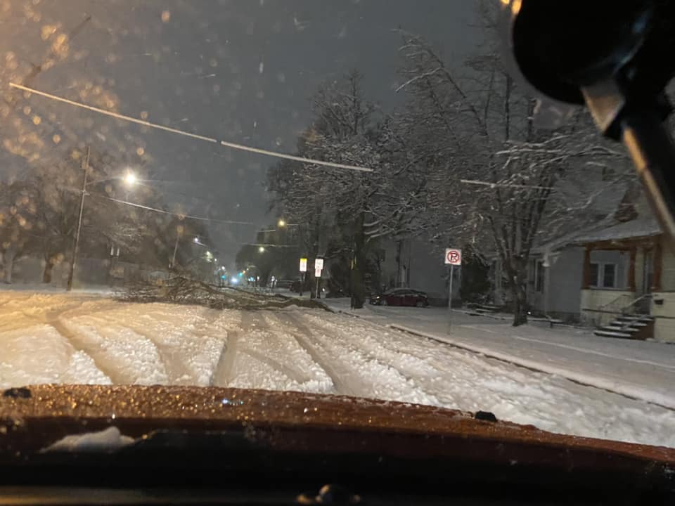
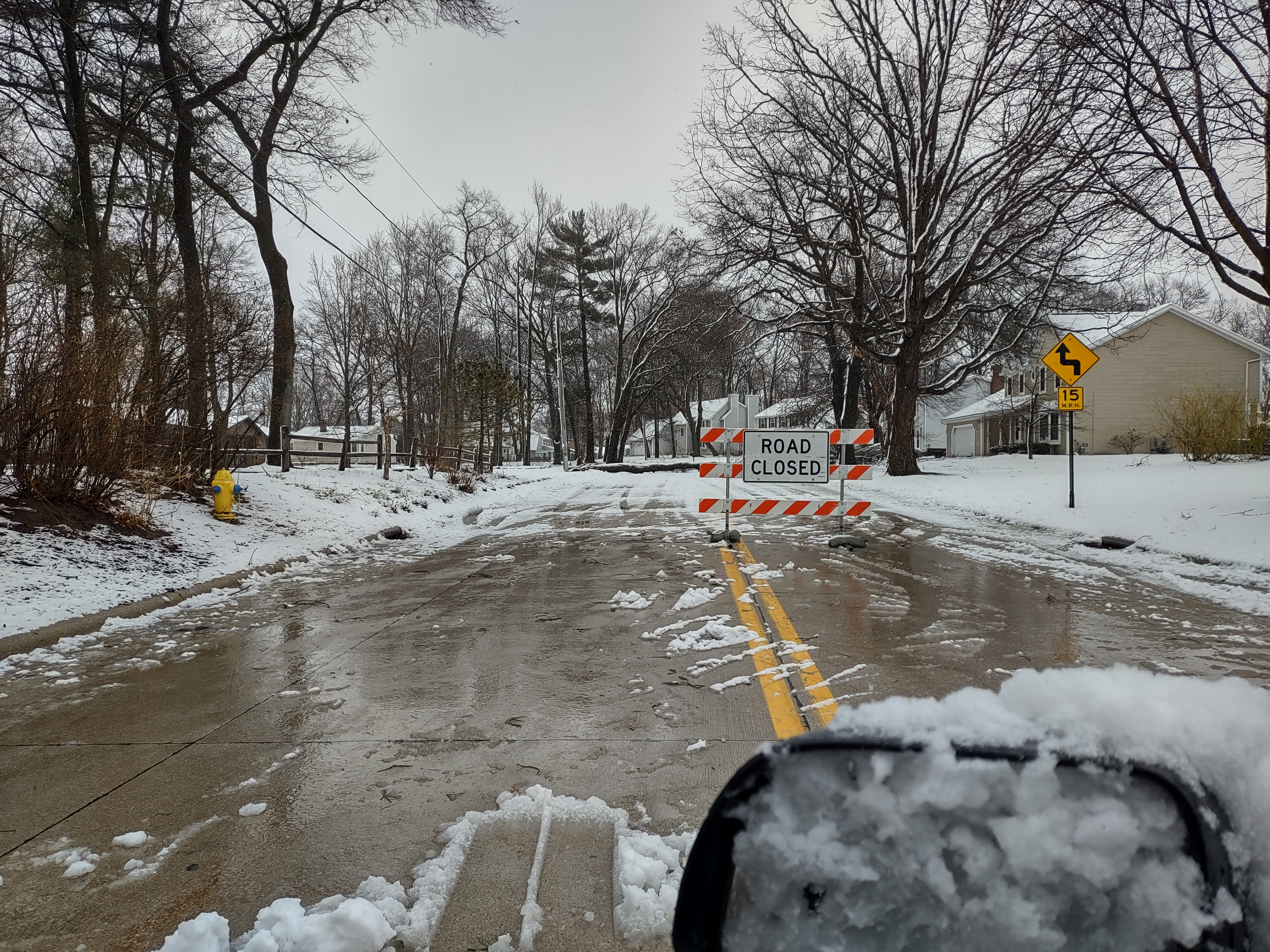
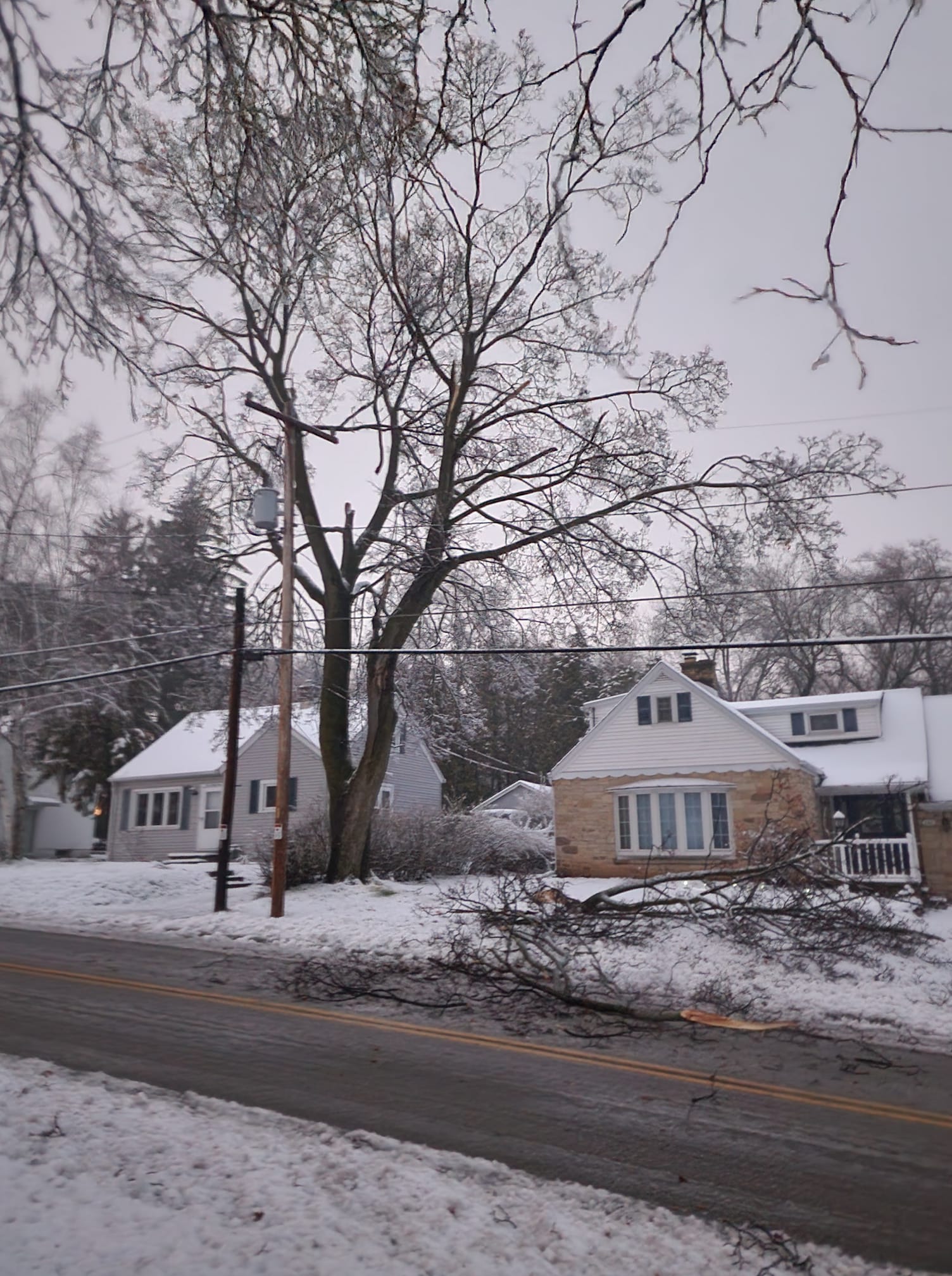
Photos
|
|
 |
|
| Photo Courtesy: Austin Kealey (Appleton) | Photo Courtesy: Dani Rae (Allouez) | Photo Courtesy: Rich Mamrosh (Green Bay) |
Satellite Evolution
One of the key aspects of this winter storm that contributed to making the system stronger and allowing it to track further west than initial forecasts was the phasing of upper-level jet enegry from both the southern and northern air streams. In the GOES-16 mid-level water vapor animation (shown below), we can see this evolution evolve nicely. First, note the shortwave impulse (denoted by the white "X") that tracked from the northern Texas Panhandle, across Kansas, southeast Iowa, northern Illinois and eventually into northeast Wisconsin. This was the primary upper-level shortwave energy that contributed to focused and intense upward motion and the development of widespread precipitation over eastern Iowa, which subsequently expanded north across Wisconsin on Tuesday April 2. However, a second significant upper-level jet feature can also be observed dropping southward across North Dakota, Minnesota and eventually turning more easterly across Illinois. This northern stream jet energy was also very dyanmic in that it also generated strong upward motion. This enhanced upward motion resulted in scattered elevated convection and numerous lightning strickes (yellow oval). This northern stream energy was important to the evolution of the winter storm in that it helped to strengthen (deepen) the upper-level trough and further contributed to the rapid expansion of the precipitation as described earlier. The phasing of these two primary jet features over the Midwest by late on April 2 ultimately resulted in the rapid intensification of the surface low and a surface low track that was slower and further west than initial model forecasts of this system. Finally, note how the leading primary shortwave ("grey-colored "x") slowed down over Lake Michigan and eventually began to drift back to the west before rapidly weakening over central Wisconsin.
The second GOES-16 DCPD animation (below) is a close-up view of the primary shortwave disturbance that rapidly strengthened over southeast Wiscosnsin and central Lake Michigan. Note the tight cyclonic swirl in the clouds and the numerous light strikes that occurred immediately ahead of this feature. This animation illustrates the most intense phase of the winter storm.
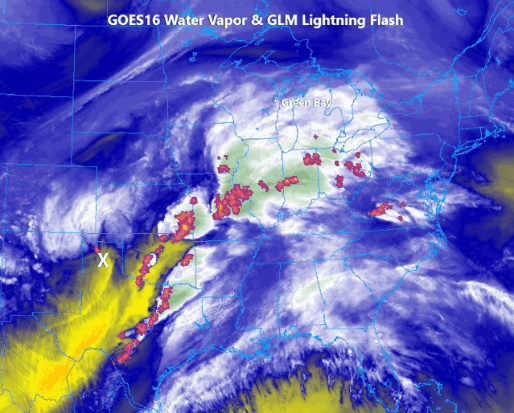
GOES-16 Water Vapor Loop (above) showing evolution of the April 2-3 WInter Storm. The white "X"s denote primary upper-level features. Yellow arrows denote approximate axis of northern stream jet energy. Yellow oval denoted area of scattered elevated convection associated with norther stream jet energy. GOES-16 GLM lightning flashes are overlaid.
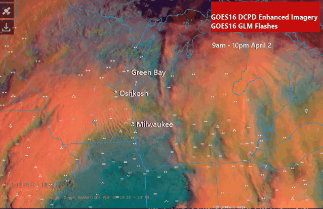
GOES-16 Day Cloud Phase Distinction (DCPD) Enhanced Imagery and GOES-16 Geostationary Lightning Mapper (GLM) Flashes from 9 am - 10 pm April 2 (above). Present weather symbols are plotted in white.
Radar
The radar animation below encompasses the main phase of the winter storm as heavy precipitation broke out over eastern Iowa and southern Wiscosnin and rapidly expanded northward across Wisconsin. Note how the precipitation swirl lingered over Wisconsin as the upper-level system slowed down over the region. Mainly rain or a mixture of rain/snow was observed over much of the forecast area during day on Tuesday April 2, before changing over to heavy wet snow over most areas, except within a few miles of Lake Michigan where the relatively warmer waters kept near surface temperatures in the middle to upper 30s resulting in mainly rain.
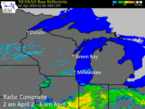
Composite Radar loop from 2 am April 2 - 6 am April 3.
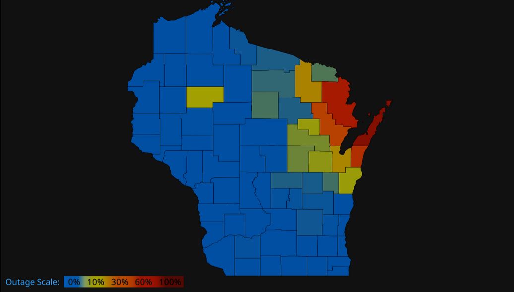
Percentage of electric customers without power at and just beyond the height of the storm, showing the worst power outages in far northeast Wisconsin. (Image Courtesy: PowerOutage.us)
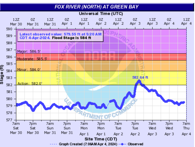
Water levels rose above action stage on the southern bay at Green Bay (where the Fox River empties into the Bay) due to the strong north/northeast winds rushing down the Bay. The river rose above action stage the evening of April 2, peaking at 582.64 ft at 9:40 pm.
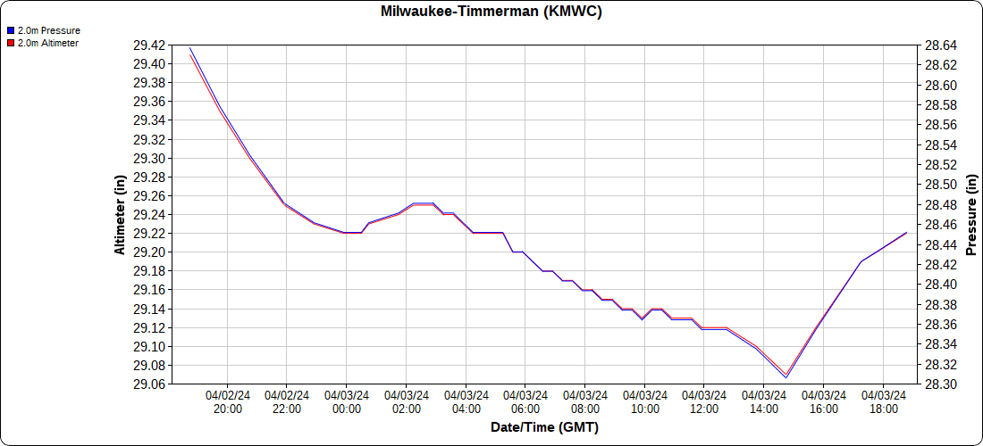
Graph shows the pressure fall at Milwaukee-Timmerman Field late in the evening on April 2 through the morning on April 3, indicating the presence of the strengthening storm. Date and time in GMT.
Peak Winds
...PEAK 24-HOUR WIND GUST REPORTS...


Location                     Speed     Time/Date       Lat/Lon/Elev (ft.)

...Wisconsin...

...Brown County...
Green Bay Airport            56 MPH    0756 PM 04/02   44.48N/88.13W/686
I-43 Se End Of Leo Frigo Bri 50 MPH    1109 PM 04/02   44.51N/88.04W/606
Green Bay 1 N                45 MPH    1118 PM 04/02   44.54N/88.00W
Green Bay                    41 MPH    0858 PM 04/02   44.58N/88.09W/656
Green Bay                    41 MPH    1045 PM 04/02   44.50N/88.01W/600
Wrightstown                  37 MPH    0749 PM 04/02   44.33N/88.17W/652
De Pere                      35 MPH    1110 PM 04/02   44.44N/88.05W/643
I43 Sb At Superior Ave - She 35 MPH    0300 AM 04/03   44.45N/87.77W/853

...Door County...
Chambers Island 1 NNW        46 MPH    0740 PM 04/02   45.20N/87.36W
Sturgeon Bay Airport         44 MPH    0504 PM 04/02   44.85N/87.42W/685
Ephraim                      39 MPH    0455 PM 04/02   45.13N/87.18W/747
Carlsville 4.1 SW (MAWN)     31 MPH    0740 PM 04/02   44.88N/87.33W/731
Egg Harbor 3.1 SE (MAWN)     31 MPH    0505 PM 04/02   45.01N/87.23W/728

...Kewaunee County...
Kewaunee MET, WI             50 MPH    0230 AM 04/03   44.47N/87.50W/583
Luxemburg 2.0 NE (MAWN)      31 MPH    1040 PM 04/02   44.56N/87.65W/714

...Langlade County...
Antigo Airport               39 MPH    0415 AM 04/03   45.15N/89.12W/1518
Antigo 2 ENE                 37 MPH    0305 AM 04/03   45.16N/89.11W/1499

...Lincoln County...
Merrill Airport              37 MPH    0455 AM 04/03   45.20N/89.72W/1310
Tomahawk Airport             30 MPH    0235 AM 04/03   45.47N/89.82W/1465

...Manitowoc County...
Two Creeks                   47 MPH    0150 AM 04/03   44.27N/87.55W/649
Manitowoc                    37 MPH    1205 AM 04/03   44.09N/87.66W/1991
Manitowoc Airport            37 MPH    0211 AM 04/03   44.12N/87.67W/618

...Marathon County...
Knowlton                     50 MPH    0134 AM 04/03   44.73N/89.70W/1128
Wausau Airport               39 MPH    0546 AM 04/03   44.93N/89.62W/1208
Marshfield                   39 MPH    0530 AM 04/03   44.76N/90.10W/1312
Mosinee Airport              38 MPH    0647 AM 04/03   44.78N/89.67W/1282
Moon 6 SW                    32 MPH    0505 AM 04/03   44.70N/89.87W/1149

...Marinette County...
Wausaukee 2 NW               34 MPH    0305 AM 04/03   45.39N/87.97W/763

...Oconto County...
Oconto Airport               39 MPH    0815 PM 04/02   44.87N/87.92W/602

...Oneida County...
Rhinelander Airport          39 MPH    0239 AM 04/03   45.63N/89.48W/1599
Tomahawk 3 W                 38 MPH    0210 AM 04/03   45.59N/89.72W/1535
Rhinelander                  32 MPH    0415 AM 04/03   45.65N/89.27W/1598

...Outagamie County...
Appleton Airport             41 MPH    1045 PM 04/02   44.27N/88.52W/888
Appleton                     32 MPH    0807 PM 04/02   44.29N/88.46W/830

...Portage County...
Stevens Point Airport        32 MPH    0615 AM 04/03   44.55N/89.53W/1106
Plover                       31 MPH    1147 PM 04/02   44.44N/89.55W/1082

...Shawano County...
Shawano Airport              40 MPH    0315 AM 04/03   44.78N/88.57W/814

...Vilas County...
Arbor Vitae Airport          38 MPH    0535 AM 04/03   45.93N/89.73W/1620
Manitowish Waters Airport    37 MPH    0635 AM 04/03   46.12N/89.88W/1606
Eagle River Airport          33 MPH    0235 AM 04/03   45.93N/89.27W/1641
Land O Lakes                 32 MPH    0135 AM 04/03   46.15N/89.22W/1694
Phelps 2 SW                  30 MPH    0602 AM 04/03   46.04N/89.10W/1770

...Waupaca County...
Clintonville Airport         33 MPH    1115 PM 04/02   44.62N/88.73W/816

...Waushara County...
Wautoma Airport              31 MPH    0707 PM 04/02   44.03N/89.30W/855

...Winnebago County...
Oshkosh Airport              46 MPH    0730 PM 04/02   43.97N/88.55W/794

...Wood County...
Marshfield Airport           45 MPH    0112 AM 04/03   44.63N/90.18W/1241
Wisconsin Rapids Airport     40 MPH    0902 PM 04/02   44.37N/89.83W/1020

...Maritime Stations...
Chambers Island              46 MPH    1020 PM 04/02   45.20N/87.36W/565
Gills Rock 1 ENE             41 MPH    0400 PM 04/02   45.29N/86.98W

Observations are collected from a variety of sources with varying
equipment and exposures. We thank all volunteer weather observers
for their dedication. Not all data listed are considered official.
 |
Media use of NWS Web News Stories is encouraged! Please acknowledge the NWS as the source of any news information accessed from this site. |
|


.gif)