
Flash flooding threatens areas from the Tennessee Valley to the Carolinas as storms repeat along a stalled front. Monsoonal storms may trigger flooding in the Southwest. Dangerous heat expands across the Desert Southwest, Plains, mid-Mississippi Valley and Southern Tier. Critical fire weather for interior Pacific Northwest. Cooler, drier air brings brief relief to the Great Lakes and Northeast. Read More >
Overview
|
A Mesoscale Convective Vortex (MCV), left over from overnight thunderstorms across Missouri, moved into central Illinois on Wednesday, June 18th. Several tornadoes occurred near the track of this feature during the midday and early afternoon hours. At the same time, a line of severe thunderstorms quickly developed just west of the I-57 corridor and moved into Indiana around mid afternoon, producing wind damage. |
.gif) A loop of radar reflectivity from KILX on June 18, 2025. |
Tornadoes
Select a tornado from the table to zoom into the track and view more information. The default table view is limited to 8 tracks, but can be scrolled by a mouse wheel or dynamically expanded. Additionally, the table can fill the entire window by clicking the small circular expanding arrow icon at the very top right of the table and returned to its original size by clicking the button again. The side information panel that opens over the map can be closed using the "X" on the upper right corner of the pop-up. Zoom into the map and click damage points to see detailed information and pictures from the surveys.
|
NOTE: times shown below are local to your device's time zone. |

The Enhanced Fujita (EF) Scale classifies tornadoes into the following categories:
| EF0 Weak 65-85 mph |
EF1 Moderate 86-110 mph |
EF2 Significant 111-135 mph |
EF3 Severe 136-165 mph |
EF4 Extreme 166-200 mph |
EF5 Catastrophic 200+ mph |
 |
|||||
| Tornadoes that fail to impact any ratable damage indicators on the EF-Scale are rated EF-Unknown (EF-U) | |||||
Storm Reports
Preliminary Local Storm Report...Summary
National Weather Service Lincoln IL
352 PM CDT Fri Jun 20 2025
..TIME... ...EVENT... ...CITY LOCATION... ...LAT.LON...
..DATE... ....MAG.... ..COUNTY LOCATION..ST.. ...SOURCE....
..REMARKS..
1145 AM Tstm Wnd Dmg Beecher City 39.19N 88.78W
06/18/2025 Effingham IL Public
Approximately 6 inch diameter tree blown
down. Photo shared via social media. Time
estimated from radar.
1154 AM Tornado 2 WNW Lynnville 39.69N 90.38W
06/18/2025 Scott IL NWS Storm Survey
EF-1 tornado with maximum winds of 100 mph.
The tornado was on the ground for 0.7 miles
and caused damage to large power poles,
trees, and roofing material on a home.
1158 AM Tstm Wnd Dmg 1 WSW South Jacksonvill 39.71N 90.26W
06/18/2025 Morgan IL Public
Corn flattened in a narrow path near the
water tower on Massey View Rd.
1200 PM Tstm Wnd Dmg Altamont 39.06N 88.75W
06/18/2025 Effingham IL Trained Spotter
Report of trees and power lines down in
town.
1200 PM Tstm Wnd Dmg Altamont 39.06N 88.75W
06/18/2025 Effingham IL Trained Spotter
Large branches down.
1200 PM Tornado 1 S Jacksonville 39.72N 90.23W
06/18/2025 Morgan IL Emergency Mngr
1201 PM Tstm Wnd Dmg Altamont 39.06N 88.75W
06/18/2025 Effingham IL Public
Approximately 12 inch diameter tree snapped
in Altamont. Photo shared via social media.
Time estimated from radar.
1202 PM Tstm Wnd Dmg 1 NNW Jacksonville 39.75N 90.23W
06/18/2025 Morgan IL Broadcast Media
Photo of pieces of sheet metal and
insulation debris in a lawn. Tree limbs
downed as well. Time estimated from radar.
1202 PM Tornado 2 W Jacksonville 39.73N 90.27W
06/18/2025 Morgan IL NWS Storm Survey
EF-1 tornado with max winds of 100 mph. The
tornado tracked 3.6 miles and was on the
ground for 8 minutes. It damaged a power
company outbuilding, a sports complex,
numerous trees, and caused roofing damaged
to a few residential homes.
1203 PM Tornado Jacksonville 39.73N 90.23W
06/18/2025 Morgan IL Emergency Mngr
Tornado reported on northwest side of
Jacksonville.
1204 PM Tstm Wnd Dmg Sullivan 39.60N 88.61W
06/18/2025 Moultrie IL Broadcast Media
Corrects location of previous tstm wnd dmg
report from Effingham. Half of a large tree
blown down onto a home in Sullivan.
1207 PM Tornado 2 ENE Jacksonville Airp 39.78N 90.21W
06/18/2025 Morgan IL NWS Storm Survey
EF-2 tornado with max winds of 125 mph. The
tornado tracked 6.74 miles and was on the
ground for 12 minutes. It damaged several
trees, large power poles, a farmstead, and a
couple houses.
1215 PM Tstm Wnd Gst Chatham 39.68N 89.70W
06/18/2025 E55 MPH Sangamon IL Storm Chaser
1215 PM Tstm Wnd Dmg 3 NW Divernon 39.59N 89.69W
06/18/2025 Sangamon IL Public
Corn nearly flattened between Auburn and
I-55. Social media report.
1219 PM Tornado 2 E Prentice 39.85N 90.01W
06/18/2025 Morgan IL NWS Storm Survey
EF-0 tornado with maximum winds of 80 mph.
It tracked just under a mile and was on the
ground for 2 minutes. It damaged a few trees
along its path before it dissipated.
1221 PM Tornado 2 SE Philadelphia 39.90N 90.09W
06/18/2025 Cass IL Emergency Mngr
Tornado reported on the ground...crossing
125 between Philadelphia and Ashland.
1221 PM Tornado 1 E Literberry 39.85N 90.18W
06/18/2025 Morgan IL Emergency Mngr
Tornado reported on the ground.
1230 PM Tstm Wnd Dmg Mattoon 39.48N 88.37W
06/18/2025 Coles IL Public
Large tree uprooted. Photo shared via social
media.
1230 PM Tstm Wnd Dmg Mattoon 39.48N 88.37W
06/18/2025 Coles IL Public
Tree branches down.
1230 PM Tstm Wnd Dmg 2 S Pleasant Plains 39.85N 89.92W
06/18/2025 Sangamon IL Public
Report of trees snapped on Pleasant Plains
Rd.
1230 PM Tstm Wnd Dmg 3 W Pleasant Plains 39.87N 89.98W
06/18/2025 Sangamon IL Fire Dept/Rescue
Grain bin blown over at Pleasant Plains Rd
and Watts Rd.
1230 PM Tornado 4 S Pleasant Plains 39.82N 89.92W
06/18/2025 Sangamon IL NWS Storm Survey
EF-1 tornado with max winds of 100 mph. It
tracked 7.35 miles. It snapped severe large
trees, tossed a pair of grain bins, and
removed shingles from a home.
1230 PM Rain 2 E Bloomington 40.48N 88.96W
06/18/2025 M1.02 Inch McLean IL NWS Employee
1233 PM Tstm Wnd Dmg Effingham 39.12N 88.54W
06/18/2025 Effingham IL Public
Social media photo of 3-6 inch diameter tree
limb blown onto a vehicle causing damage.
1234 PM Tstm Wnd Dmg Pesotum 39.91N 88.27W
06/18/2025 Champaign IL Fire Dept/Rescue
Corned flattened from Tolono south to nearly
Tuscola. Time estimated from radar.
1235 PM Tstm Wnd Dmg 1 W Tuscola 39.80N 88.30W
06/18/2025 Douglas IL Public
Gravity wagons flipped and tree limbs downed
by thunderstorm winds. Time estimated from
radar.
1235 PM Tstm Wnd Dmg Tuscola 39.80N 88.28W
06/18/2025 Douglas IL Public
3-6 inch diameter tree limbs blown down.
Photo shared via social media. Time
estimated from radar.
1241 PM Tornado 3 NNE Tallula 39.99N 89.92W
06/18/2025 Menard IL NWS Storm Survey
EF-1 tornado with max winds of 110 mph. It
tracked 1.4 miles and caused tree damage,
destroyed 5 grain bins, and removed shingles
from two homes.
1244 PM Tstm Wnd Gst Willard Airport 40.04N 88.28W
06/18/2025 M59 MPH Champaign IL Official NWS Obs
Peak wind at KCMI ASOS.
1245 PM Tstm Wnd Dmg Petersburg 40.01N 89.85W
06/18/2025 Menard IL Broadcast Media
Trees and limbs snapped, corn flattened, and
part of a silo or shed blown across roadway
into a field. Time estimated from radar.
1247 PM Tstm Wnd Dmg Philo 40.01N 88.16W
06/18/2025 Champaign IL Public
Large tree blown down onto a chain link
fence, causing damage to the fence. Photo
shared via social media. Time estimated from
radar.
1250 PM Tstm Wnd Dmg 1 WSW Rantoul 40.30N 88.18W
06/18/2025 Champaign IL Public
Snapped power poles near the sports complex,
plus several trees damaged in town.
1250 PM Tornado Rantoul 40.30N 88.16W
06/18/2025 Champaign IL Trained Spotter
Power lines down in Rantoul...near the
Family Sports Complex.
1253 PM Tstm Wnd Dmg Oakland 39.66N 88.03W
06/18/2025 Coles IL Public
Large tree uprooted and blown onto a house
causing structural damage. Photo shared via
social media. Time estimated from radar.
1255 PM Funnel Cloud 2 NE Oakland 39.68N 88.00W
06/18/2025 Coles IL Emergency Mngr
0100 PM Tstm Wnd Dmg 3 WSW Hutton 39.40N 88.14W
06/18/2025 Coles IL Public
Large tree limb down in Fox Ridge State
Park. Time estimated from radar.
0100 PM Rain 1 SW Meredosia 39.82N 90.57W
06/18/2025 M1.76 Inch Morgan IL Mesonet
Mesonet station MROI2 0.8 SW Meredosia.
0110 PM Tstm Wnd Dmg Jamaica 39.99N 87.81W
06/18/2025 Vermilion IL Public
Old township building blown off its
foundation. Time estimated from radar.
0115 PM Tstm Wnd Dmg 3 N Casey 39.34N 87.99W
06/18/2025 Clark IL Public
Large tree branch fell through a roof.
0118 PM Tornado 2 NNE Mason City 40.23N 89.67W
06/18/2025 Mason IL NWS Storm Survey
EF-0 tornado with max winds of 75 mph. The
tornado was brief with a path of one tenth
of a mile. It knocked over a tree, tree
limbs, and corn before dissipating.
0119 PM Tstm Wnd Gst 1 WSW Kansas 39.55N 87.95W
06/18/2025 E70 MPH Edgar IL Trained Spotter
Trained spotter estimated winds to 70 mph.
Reported 7-8 power poles snapped along IL-16
1 mile WSW Kansas.
0119 PM Tstm Wnd Dmg 1 WSW Kansas 39.55N 87.95W
06/18/2025 Edgar IL Trained Spotter
Trained spotter estimated winds to 70 mph.
Reported 7-8 power poles snapped along IL-16
1 mile WSW Kansas.
0119 PM Tornado 2 NE Mason City 40.22N 89.67W
06/18/2025 Mason IL Emergency Mngr
Rain-wrapped tornado on ground headed toward
San Jose.
0125 PM Tstm Wnd Dmg 1 NNE Paradise 39.42N 88.43W
06/18/2025 Coles IL Public
Numerous large tree branches broken near
Lake Paradise.
0126 PM Tstm Wnd Dmg 4 E Rossville 40.37N 87.59W
06/18/2025 Vermilion IL Public
Grain bins crumpled at the intersection of
Antioch Rd. and Attica Rd.
0127 PM Tstm Wnd Dmg Hoopeston 40.47N 87.67W
06/18/2025 Vermilion IL Public
Estimated 12 inch or greater diameter tree
blown down. Photo shared via social media.
Time estimated from radar.
0130 PM Tstm Wnd Gst Hoopeston 40.47N 87.67W
06/18/2025 M71 MPH Vermilion IL Trained Spotter
Relayed by Emergency Management.
0130 PM Tstm Wnd Dmg Hoopeston 40.47N 87.67W
06/18/2025 Vermilion IL Emergency Mngr
Multiple tree branches down.
0131 PM Tstm Wnd Dmg 4 E Danville 40.13N 87.55W
06/18/2025 Vermilion IL Public
Corn flattened. Social media report.
0142 PM Tstm Wnd Dmg Chauncey 38.83N 87.87W
06/18/2025 Lawrence IL Public
Chauncey fire department antenna tower blown
down by thunderstorm winds. Time estimated
from radar.
0149 PM Tornado Delavan 40.37N 89.54W
06/18/2025 Tazewell IL Fire Dept/Rescue
Report of a tornado on the ground near
Delevan...relayed by News Media.
0150 PM Tornado 4 NNE De Witt 40.24N 88.77W
06/18/2025 De Witt IL NWS Storm Survey
EF-1 tornado with max winds of 100 mph. It
tracked about 3.5 miles flattening corn,
damaging trees, and a farmstead.
0153 PM Tornado 2 N Minier 40.46N 89.31W
06/18/2025 Tazewell IL Trained Spotter
Tornado reported on the ground between
Mackinaw and Minier...relayed by Emergency
Management.
0155 PM Tstm Wnd Dmg Sidney 40.02N 88.07W
06/18/2025 Champaign IL Emergency Mngr
Large tree branches down.
0156 PM Tornado 2 NNE Hopedale 40.46N 89.40W
06/18/2025 Tazewell IL NWS Storm Survey
EF-U tornado. A video shows a brief
touchdown for about 45 seconds. No damage
was observed or reported.
0156 PM Tornado 2 S Mackinaw 40.51N 89.36W
06/18/2025 Tazewell IL Trained Spotter
Tornado reported on ground.
0156 PM Non-Tstm Wnd Gst Decatur Airport 39.83N 88.87W
06/18/2025 M51 MPH Macon IL Official NWS Obs
Corrects magnitude of previous report of
peak gradient wind at KDEC ASOS.
0156 PM Non-Tstm Wnd Gst Decatur Airport 39.83N 88.87W
06/18/2025 M49 MPH Macon IL Official NWS Obs
Peak gradient wind at KDEC ASOS.
0200 PM Tstm Wnd Dmg 1 W Lawrenceville 38.73N 87.70W
06/18/2025 Lawrence IL Emergency Mngr
Trees and limbs down across Lawrence County.
Time approximated from radar.
0201 PM Tornado 3 NW Farmer City 40.28N 88.68W
06/18/2025 De Witt IL Storm Chaser
Rain-wrapped tornado with tree debris in the
air. No structural damage.
0204 PM Tstm Wnd Gst Robinson Municipal Airp 39.01N 87.65W
06/18/2025 M62 MPH Crawford IL AWOS
AWOS station KRSV Robinson Arpt.
0210 PM Tstm Wnd Dmg Mount Carmel Airport 38.61N 87.73W
06/18/2025 Lawrence IL Emergency Mngr
Doors on airport hangers blown in by
thunderstorm winds. Time estimated from
radar.
0213 PM Tornado 1 SSW Bellflower 40.33N 88.54W
06/18/2025 McLean IL NWS Storm Survey
EF-U tornado relayed via video shows a
rope-shaped tornado occurring in a field.
There have been no reports of damage.
0213 PM Tornado 1 SSW Bellflower 40.33N 88.53W
06/18/2025 McLean IL Broadcast Media
[Delayed Report] - Video relayed by
broadcast media shows a tornado touchdown in
a field to the east of Route 54. Time
estimated by radar.
0215 PM Tstm Wnd Gst Mount Carmel Airport 38.61N 87.73W
06/18/2025 M59 MPH Lawrence IL AWOS
AWOS station KAJG Mt Carmel Arpt.
0217 PM Non-Tstm Wnd Gst Capital Airport 39.84N 89.68W
06/18/2025 M45 MPH Sangamon IL Official NWS Obs
Peak gradient wind at KSPI ASOS.
0219 PM Tstm Wnd Gst 4 SE Lawrenceville 38.69N 87.63W
06/18/2025 E60 MPH Lawrence IL Trained Spotter
Reported between Lawrenceville & Westport on
IL-33.
0220 PM Tstm Wnd Gst Lawrenceville Airport 38.76N 87.60W
06/18/2025 M67 MPH Lawrence IL ASOS
ASOS station KLWV Lawrenceville AP.
0225 PM Funnel Cloud Bellflower 40.34N 88.53W
06/18/2025 McLean IL Storm Chaser
0234 PM Non-Tstm Wnd Gst Willard Airport 40.04N 88.28W
06/18/2025 M49 MPH Champaign IL Official NWS Obs
Peak gradient wind at KCMI ASOS.
0234 PM Funnel Cloud 1 N Fisher 40.33N 88.35W
06/18/2025 Champaign IL Broadcast Media
0238 PM Non-Tstm Wnd Gst 2 NW Oconee 39.30N 89.13W
06/18/2025 M58 MPH Shelby IL Mesonet
SWOP report of measured gradient wind gusts
to 58 mph immediately south of the mesolow
from 230 to 245 pm. Sustained winds reached
44 mph.
&&
Photos & Video
Damage Photos
 |
 |
 |
 |
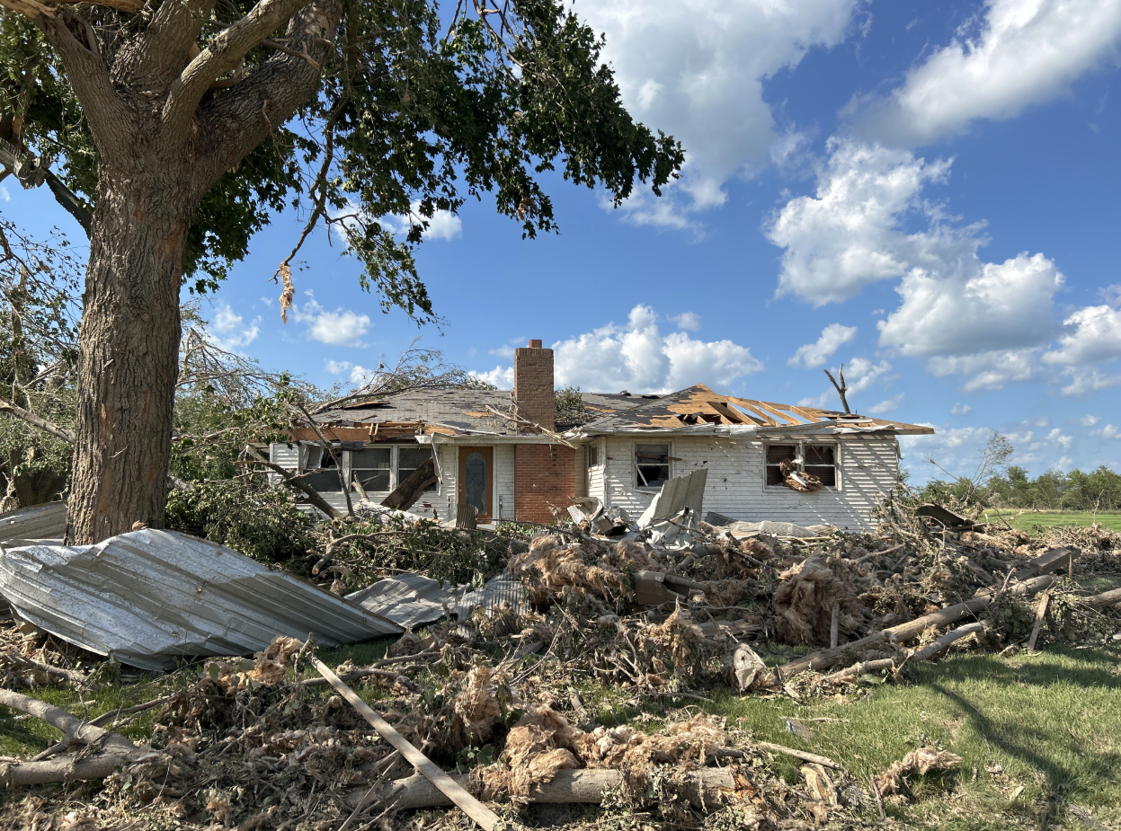
| House damaged south of Literberry (EF2) (NWS) |
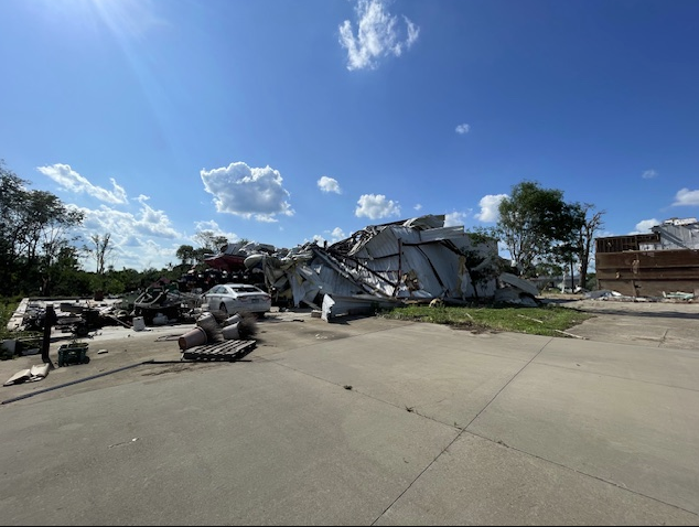
Metal framed building south of Literberry (EF2) (NWS) |
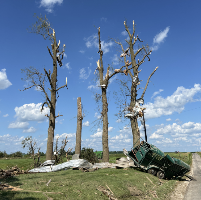
Tree damage south of Literberry (EF2) (NWS) |
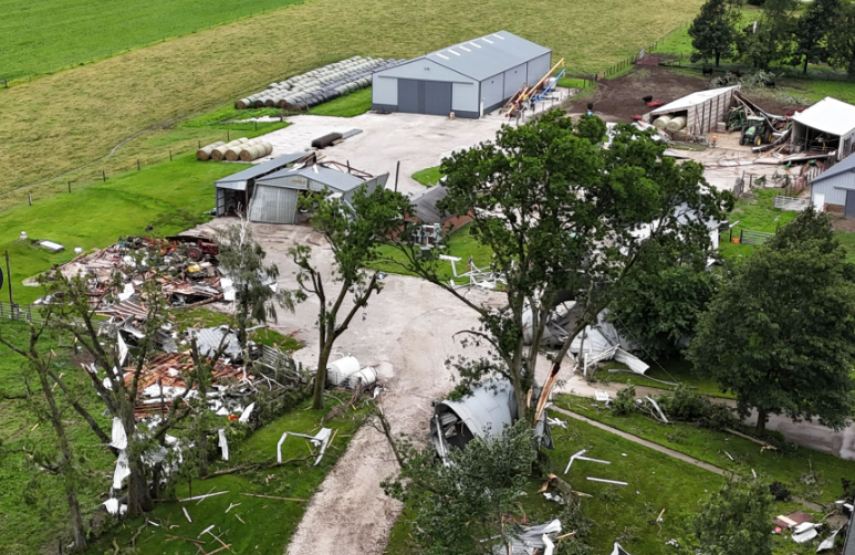
Farmstead damaged west of Petersburg (EF1) (Courtesy of Ben Hollis) |
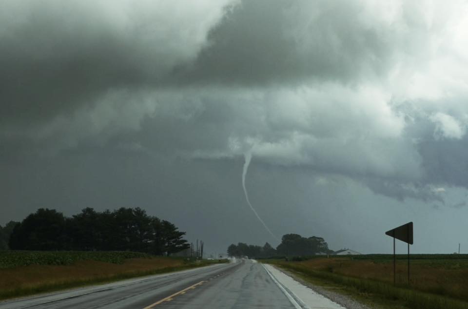
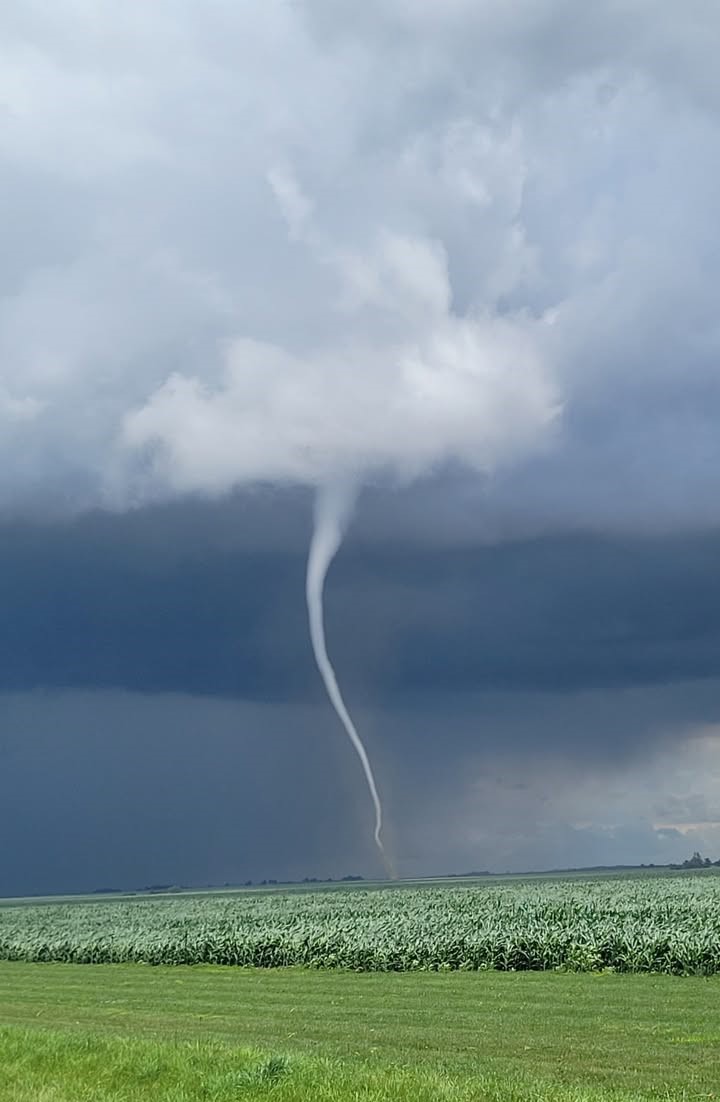
Tornado Photos
 |
 |
||
| Near Ashland (Courtesy of Ethan Schisler) |
Near Ashland (courtest of Dan Grant) |
Caption (source) |
Caption (source) |
Header
| Caption (source) |
Caption (source) |
Caption (source) |
Caption (source) |
Header
| Caption (source) |
Caption (source) |
Caption (source) |
Caption (source) |
Header
| Caption (source) |
Caption (source) |
Caption (source) |
Caption (source) |
Meteorology
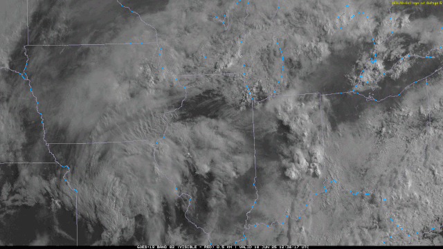
A mesoscale convective vortex, or MCV, led to thunderstorm development across Missouri and Illinois on Wednesday, June 18. An MCV is a small-scale low pressure system that forms due to latent heat release from earlier thunderstorms. Ahead of this system, seasonably high low-level moisture was present, with dewpoints in the low 70s. Breaks in the cloud cover allowed sunshine to heat the surface, resulting in moderate instability. The combination of spin from the MCV, the instability, and low cloud bases created an environment favorable for tornadoes.
 |
 |
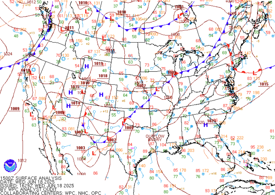 |
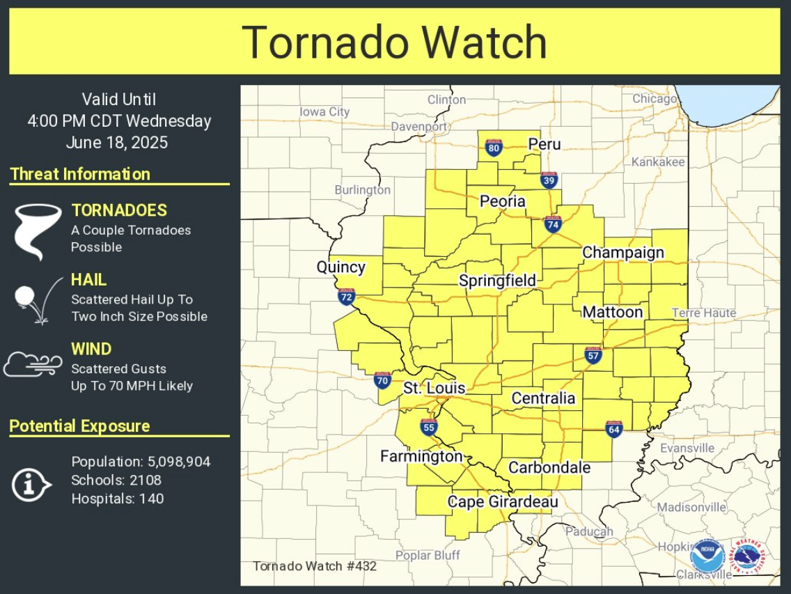
| Figure 1: Visible satellite loop | Figure 2: Tornado Watch #432 | Figure 3: 10 AM surface map |
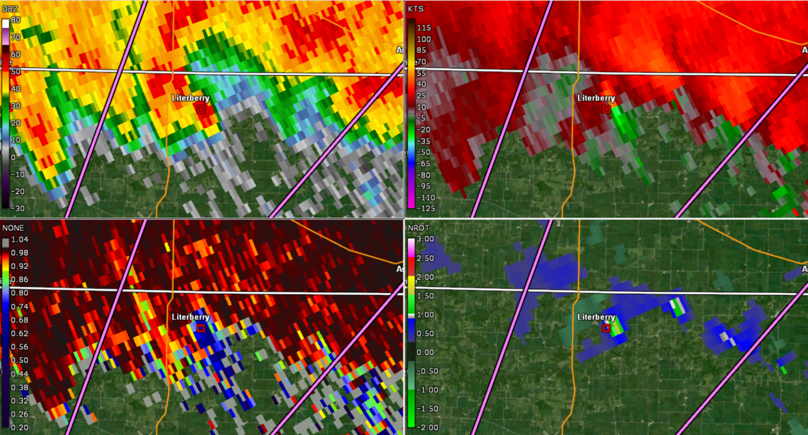
Here is a sampling of radar imagery from the event:
 |
 |
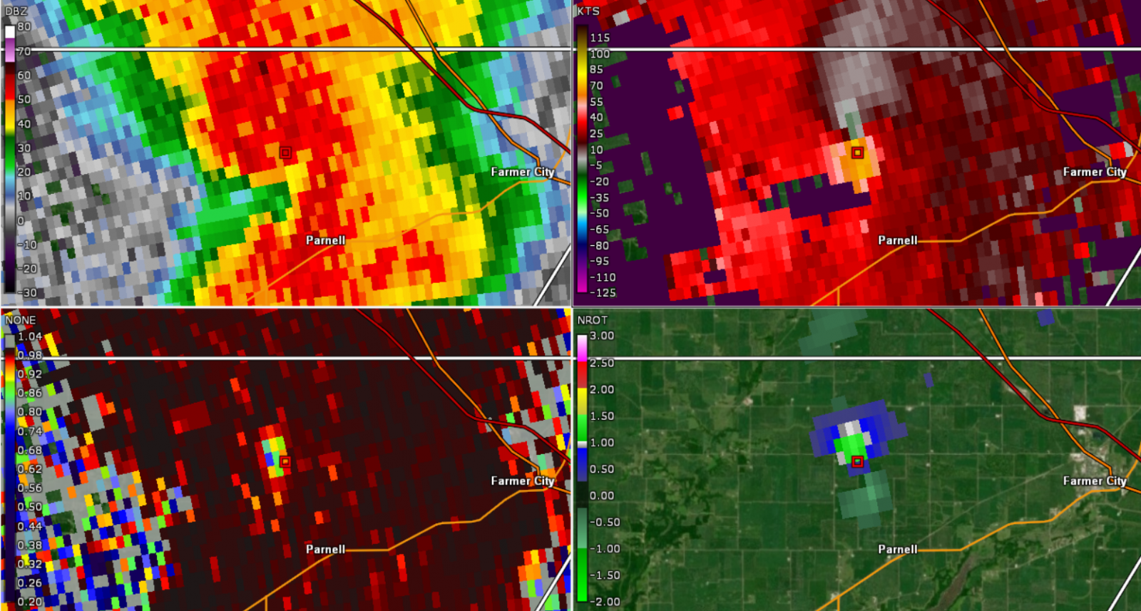 |
| Figure 4: Radar reflectivity (left) and storm-relative velocity (right). This image, from 12:05 PM, shows two areas of rotation on the north side of Jacksonville, IL. | Figure 5: Radar reflectivity (top left), storm-relative velocity (top right), correlation coefficient (bottom left), and normalized rotation (bottom right). This image, from 12:17 PM, shows a tornadic debris signature (a radar confirmed tornado) just southeast of Literberry, IL. | Figure 6: Same as figure 5, but from 1:53 PM and located to the west of Farmer City, IL. |
Additional Information
| Figure 7: Caption | Figure 8: Caption | Figure 9: Caption |
 |
Media use of NWS Web News Stories is encouraged! Please acknowledge the NWS as the source of any news information accessed from this site. |
|

