Overview
A strong low pressure system advanced across northwestern Illinois in the morning of February 27, 2023. A cold frontal passage triggering a couple waves of storms. The second wave triggered a couple of brief tornado touchdowns near Champaign/Urbana. The tornadoes were brief and weak, with no immediate reports of damage received.Tornadoes:
|
Tornado - 1 SE Bondville
Track Map .png) 
Downloadable KMZ File
|
|||||||||||||||||||||||||||||||||
The Enhanced Fujita (EF) Scale classifies tornadoes into the following categories:
| EF0 Weak 65-85 mph |
EF1 Moderate 86-110 mph |
EF2 Significant 111-135 mph |
EF3 Severe 136-165 mph |
EF4 Extreme 166-200 mph |
EF5 Catastrophic 200+ mph |
 |
|||||
Photos & Video
Header
 |
 |
 |
 |
|
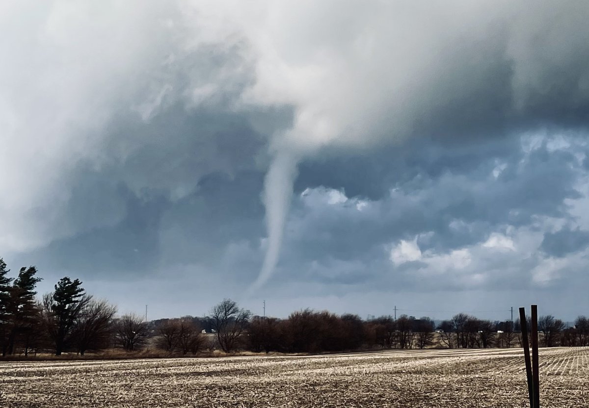
Bondville Tornado (Andrew Pritchard) |
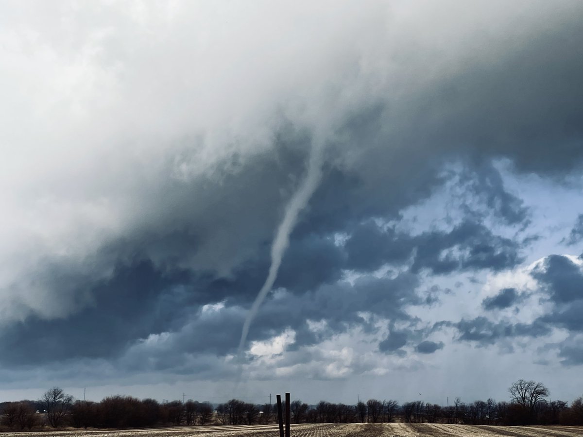
Bondville Tornado - dissipating stage (rope) (Andrew Pritchard) |
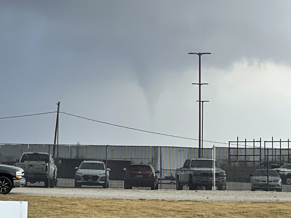
5NW Urbana Tornado (Andrew Pritchard) |
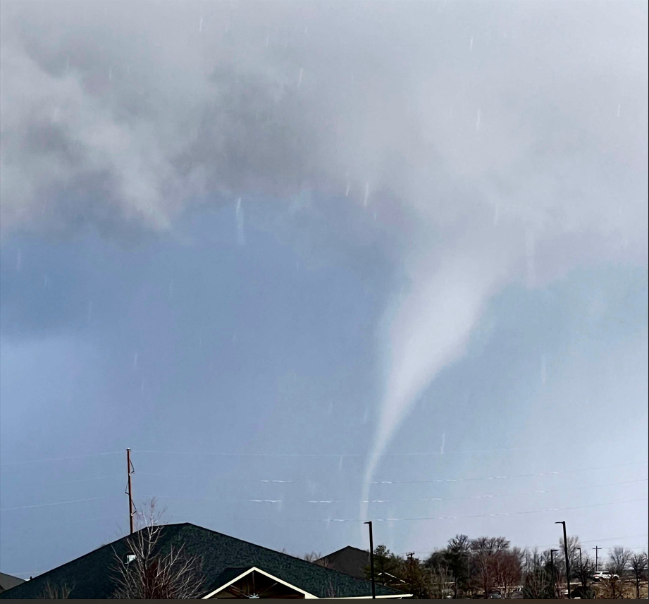
5NW Urbana Tornado (Damon Downs) |
Radar
Header
 |
 |
||
|
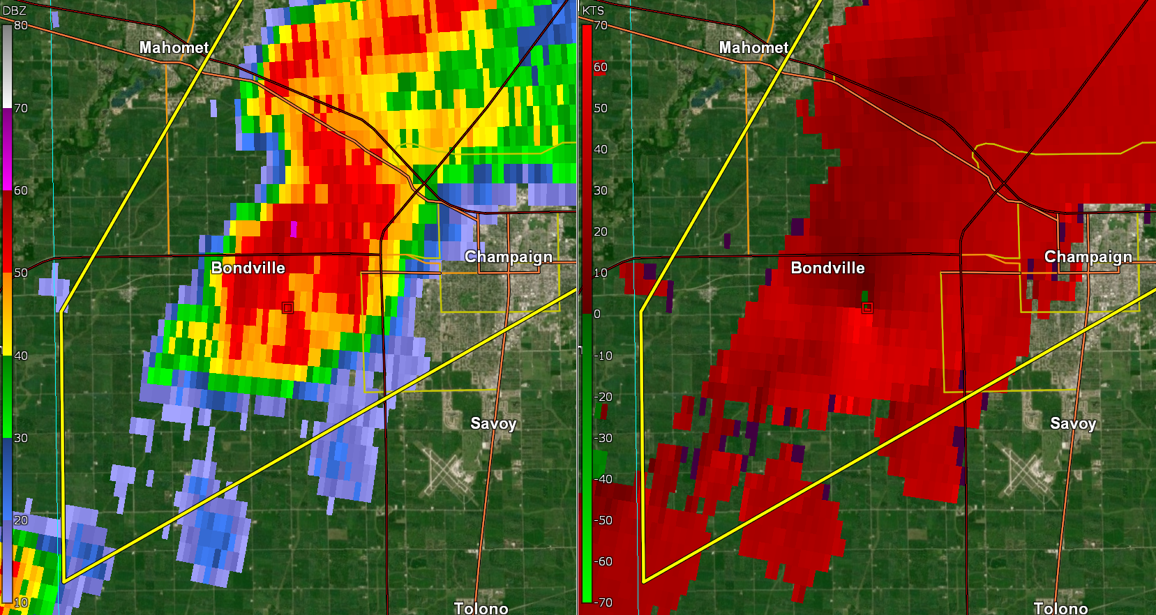
Bondville Tornado Radar time 8:43 AM CST Left side: Reflectivity Right side: Velocity |
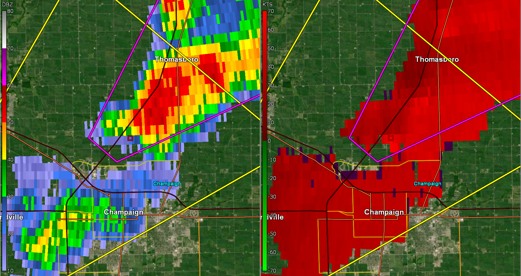
5NW Urbana Tornado Radar time 8:55 AM CST Left side: Reflectivity Right side: Velocity |
Caption | Caption |
Storm Reports
Public Information Statement...UPDATED
National Weather Service Lincoln IL
1149 AM CST Fri Mar 10 2023

Updated to add EF rating & wind speed for Bondville tornado

...NWS Damage Survey for 02/27/2023 Tornado Event...

.Bondville Tornado...

Rating:                 EF-0
Estimated Peak Wind:    80 mph
Path Length /statute/:  1.14 miles
Path Width /maximum/:   30 yards
Fatalities:             0
Injuries:               0

Start Date:             02/27/2023
Start Time:             08:43 AM CST
Start Location:         1 SE Bondville / Champaign County / IL
Start Lat/Lon:          40.0975 / -88.3564

End Date:               02/27/2023
End Time:               08:44 PM CST
End Location:           1 ESE Bondville / Champaign County / IL
End Lat/Lon:            40.1120 / -88.3460

Survey Summary: Spotters reported the tornado touching down in an
open field 1 mile southeast of Bondville. The tornado moved
northeast through open fields, hitting a farm out building on
S Baker Rd, doing minor damage. The tornado dissipated just south
of Springfield Ave, 1 mile east-southeast of Bondville.

.Urbana Tornado...

Rating:                 EF-Unknown
Estimated Peak Wind:    N/A
Path Length /statute/:  1.53 miles
Path Width /maximum/:   25 yards
Fatalities:             0
Injuries:               0

Start Date:             02/27/2023
Start Time:             08:55 AM CST
Start Location:         5 NW Urbana / Champaign County / IL
Start Lat/Lon:          40.1694 / -88.2649

End Date:               02/27/2023
End Time:               08:56 PM CST
End Location:           5 N Urbana / Champaign County / IL
End Lat/Lon:            40.1825 / -88.2415

Survey Summary: Spotters reported the tornado touch down in an open
field between I-57 and E Ford Harris Rd. The tornado moved northeast
through open fields, eventually crossing I-57 at exit number 240.
The tornado then quickly dissipated just east exit 240. No damage
was reported.

$$

Geelhart/Shimon/Auten
 |
Media use of NWS Web News Stories is encouraged! Please acknowledge the NWS as the source of any news information accessed from this site. |
|


