Overview
|
On the evening of July 15, 2024, a derecho brought very strong winds, several tornadoes, and heavy rainfall to a good portion of the Midwest. Thunderstorms initiated over central Iowa during the late afternoon hours then quickly spread east-southeast through southern Wisconsin, the northern half of Illinois, southern Michigan, and the northern/central Indiana. Significant tree damage, some structural damage, and a few tornadoes resulted from the event with observed wind speeds of 105 mph near Speer, Illinois (Stark/Marshall County line). Back building of storms during the overnight hours brought very heavy rainfall and flash flooding near and south of a Galesburg to Sullivan line. The heaviest rain fell over Fulton and Mason counties where 4-7"+ were reported. The last time a derecho impacted central parts of Illinois was back on June 29, 2023.
Derecho definition: (pronounced deh-REY-cho) a widespread, long-lived wind storm associated with a band of rapidly moving showers and thunderstorms. A storm is classified as a derecho if wind damage swatch extends more than 240 miles, and has wind gusts of at least 58 mph or greater, most of the length of the storm's path.
|
|
Tornadoes:
|
East Peoria/Morton
|
||||||||||||||||
|
||||||||||||||||
|
Monica/Princeville
|
||||||||||||||||
|
||||||||||||||||
|
Alta
|
||||||||||||||||
|
||||||||||||||||
|
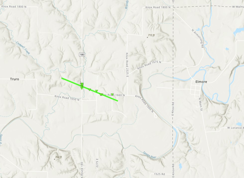
West of Elmore
|
||||||||||||||||
|
||||||||||||||||
|
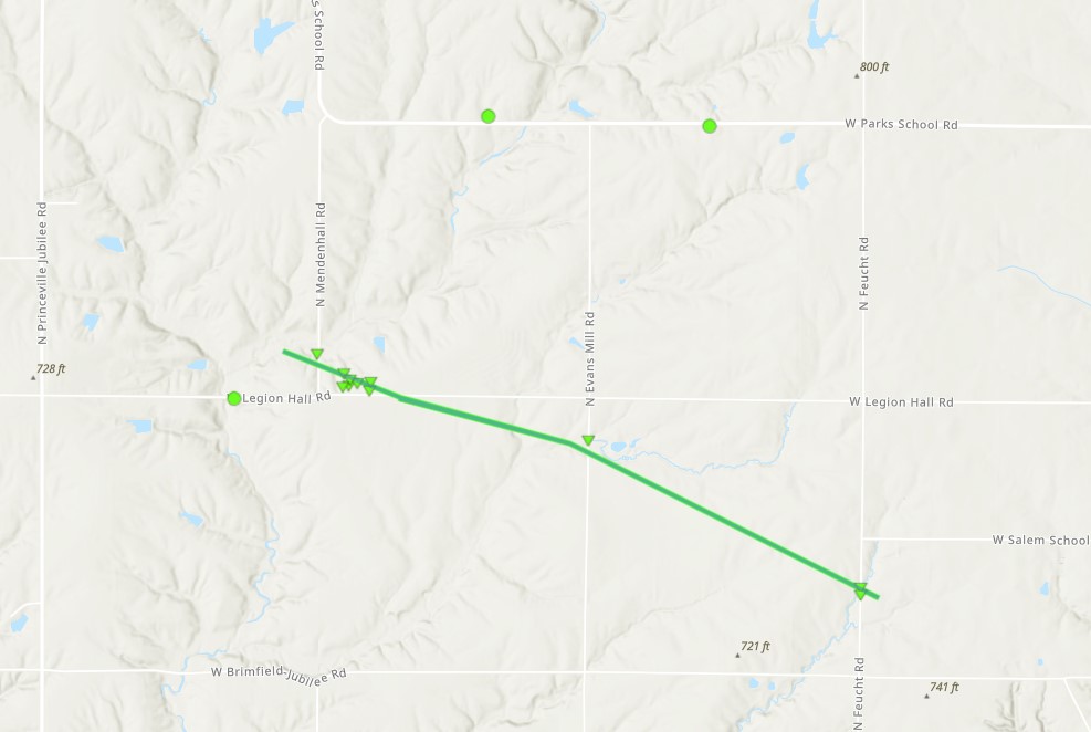
West of Dunlap
|
||||||||||||||||
|
||||||||||||||||
|
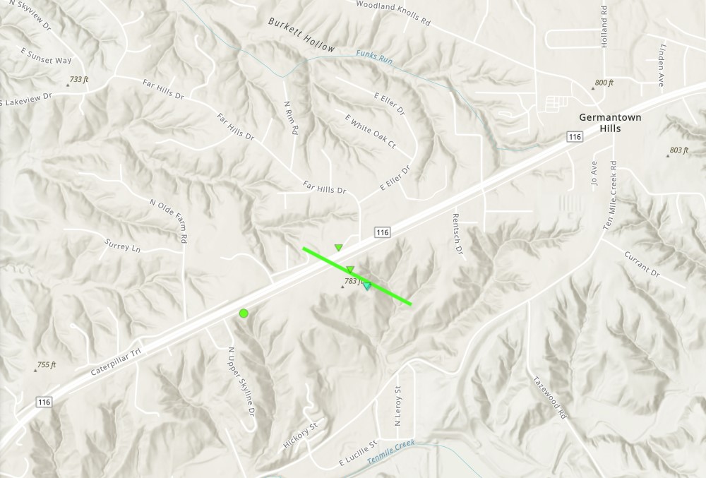
Southwest of Germantown Hills
|
||||||||||||||||
|
||||||||||||||||
|
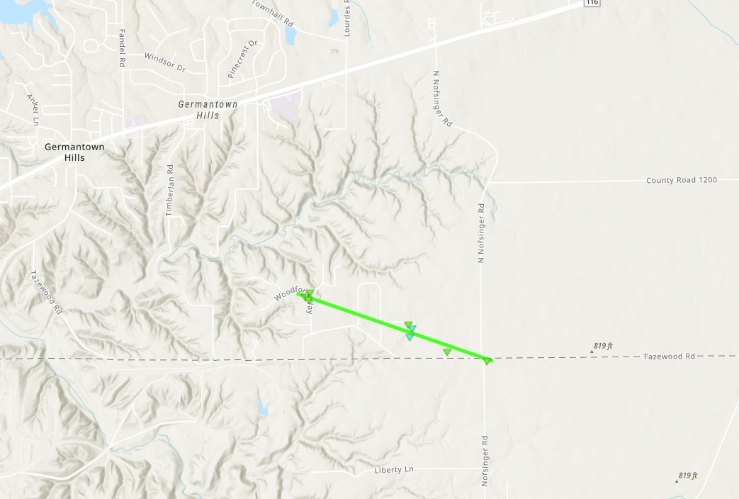
Southeast of Germantown Hills
|
||||||||||||||||
|
||||||||||||||||
|
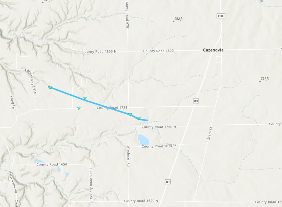
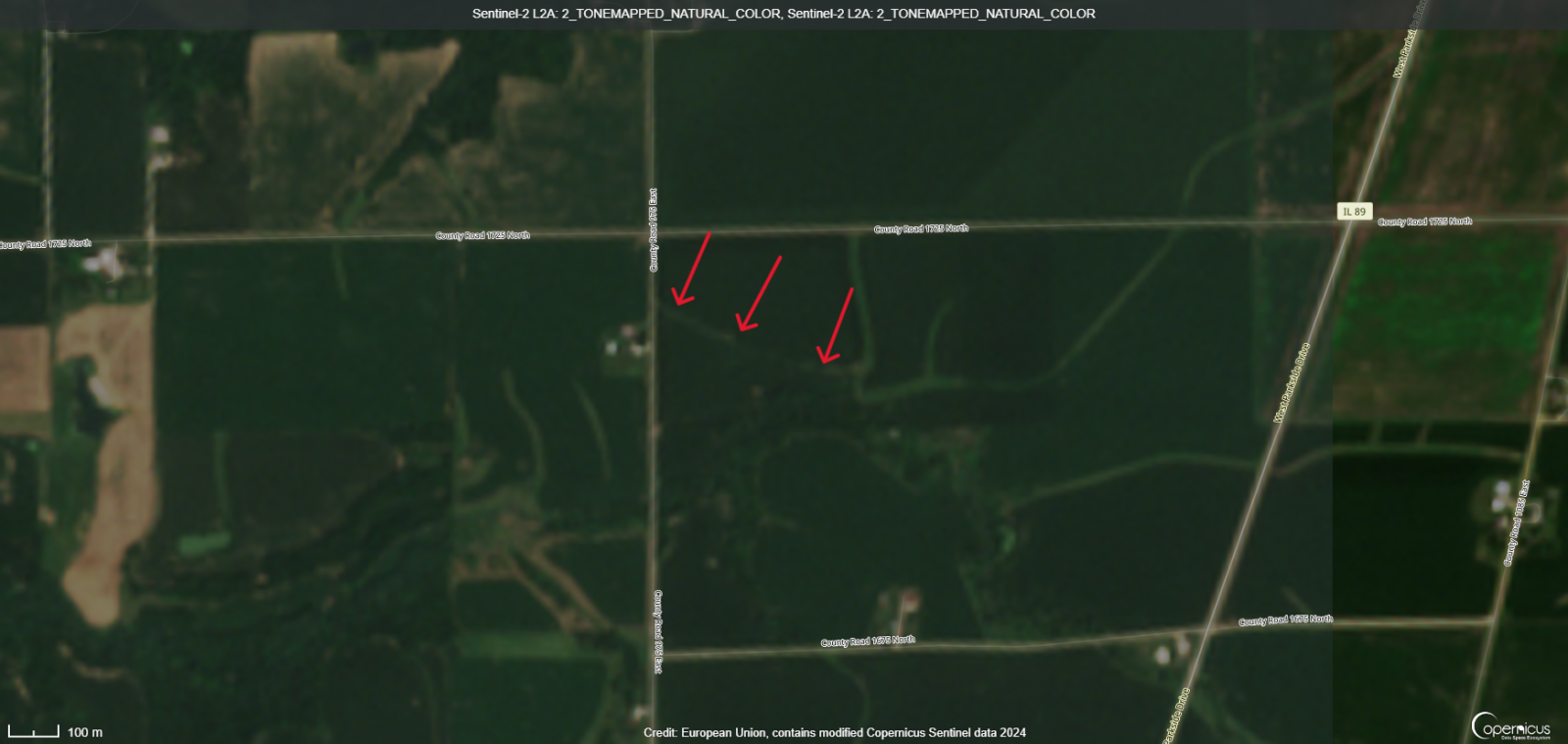
Cazenovia
|
||||||||||||||||
|
||||||||||||||||
|
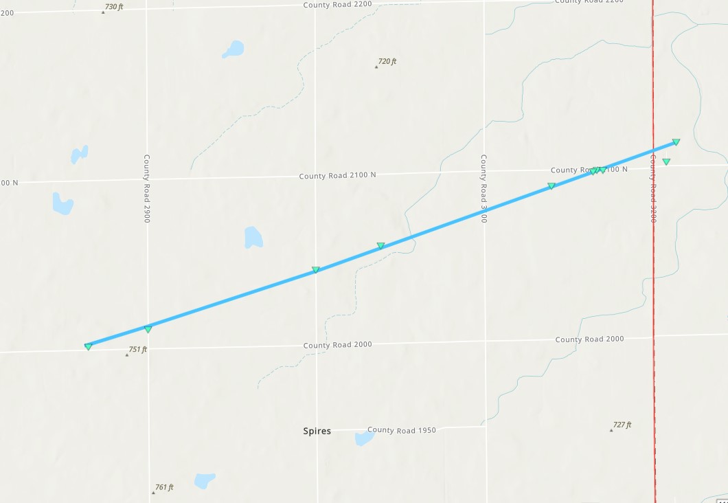
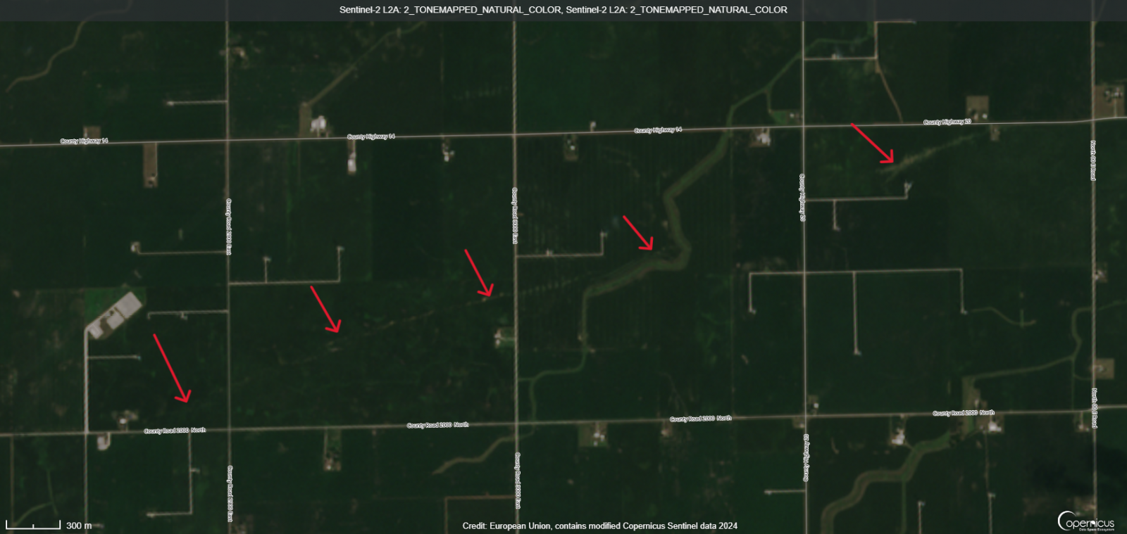
East of Minonk
|
||||||||||||||||
|
||||||||||||||||
|
North of Mackinaw
|
||||||||||||||||
|
||||||||||||||||
The Enhanced Fujita (EF) Scale classifies tornadoes into the following categories:
| EF0 Weak 65-85 mph |
EF1 Moderate 86-110 mph |
EF2 Significant 111-135 mph |
EF3 Severe 136-165 mph |
EF4 Extreme 166-200 mph |
EF5 Catastrophic 200+ mph |
 |
|||||
Storm Reports:
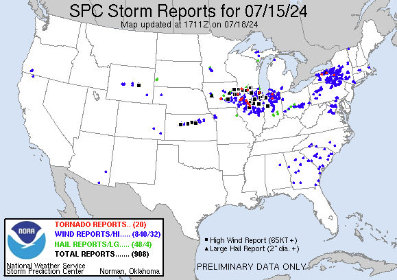
Interactive Preliminary Storm Report Map (SPC)
Preliminary Local Storm Report...Summary
National Weather Service Lincoln IL
1042 AM CDT Thu Jul 18 2024

..TIME...   ...EVENT...      ...CITY LOCATION...     ...LAT.LON...
..DATE...   ....MAG....      ..COUNTY LOCATION..ST.. ...SOURCE....
            ..REMARKS..

0815 PM     Tstm Wnd Gst     Elmwood                 40.78N 89.96W
07/15/2024  M71 MPH          Peoria             IL   Public


0822 PM     Tstm Wnd Gst     Canton                  40.56N 90.04W
07/15/2024  M65 MPH          Fulton             IL   Mesonet

            Estimated 65 mph wind gust with 4-6 inch
            tree limbs blown down and power outages.

0822 PM     Tstm Wnd Gst     Trivoli                 40.69N 89.89W
07/15/2024  M58 MPH          Peoria             IL   Fire Dept/Rescue


0825 PM     Tstm Wnd Gst     3 S Camp Grove          41.03N 89.63W
07/15/2024  M105 MPH         Marshall           IL   Public

            Measured wind gust 105 mph. Half of corn
            crib destroyed.

0830 PM     Tstm Wnd Gst     Lewistown               40.40N 90.16W
07/15/2024  M70 MPH          Fulton             IL   Emergency Mngr

            Wind gusting 60 to 70 mph from Lewistown
            ESDA.

0830 PM     Tstm Wnd Gst     2 W Bellevue            40.69N 89.72W
07/15/2024  E60 MPH          Peoria             IL   Emergency Mngr

            Estimated wind gust 60 mph.

0831 PM     Tstm Wnd Gst     Lewistown               40.40N 90.16W
07/15/2024  E60 MPH          Fulton             IL   Emergency Mngr

            Lewistown emergency manager estimated 60 mph
            wind gust.

0832 PM     Tstm Wnd Gst     Lacon                   41.02N 89.41W
07/15/2024  E85 MPH          Marshall           IL   NWS Storm Survey

            An NWS storm survey determined the damage in
            Lacon was caused by straight-line wind gusts
            of 75 to 85 mph.

0837 PM     Tstm Wnd Gst     1 N Pekin               40.58N 89.64W
07/15/2024  E65 MPH          Tazewell           IL   Trained Spotter

            Estimated wind gust 60 to 65 mph in north
            Pekin.

0840 PM     Tstm Wnd Gst     Henry                   41.11N 89.35W
07/15/2024  M80 MPH          Marshall           IL   Public

            Weather station at the Henry marina measured
            an 80 mph wind gust.

0840 PM     Tstm Wnd Gst     2 N Washburn            40.95N 89.29W
07/15/2024  E65 MPH          Marshall           IL   Trained Spotter

            Power flashes from high winds.

0841 PM     Tstm Wnd Gst     1 N South Pekin         40.51N 89.66W
07/15/2024  M78 MPH          Tazewell           IL   Trained Spotter


0845 PM     Tstm Wnd Gst     Henry                   41.11N 89.36W
07/15/2024  E70 MPH          Marshall           IL   Trained Spotter


0846 PM     Tstm Wnd Gst     2 S Morton              40.58N 89.46W
07/15/2024  M61 MPH          Tazewell           IL   Emergency Mngr

            Measured 61 mph wind gust.

0850 PM     Tstm Wnd Gst     1 SW Varna              41.03N 89.23W
07/15/2024  M60 MPH          Marshall           IL   Public


0850 PM     Tstm Wnd Gst     3 E Toluca              41.00N 89.07W
07/15/2024  M65 MPH          Marshall           IL   Mesonet

            Corrects previous tstm wnd gst report from 3
            E Toluca. Mesonet station DVI03891 Toluca.

0852 PM     Tstm Wnd Gst     Minonk                  40.90N 89.03W
07/15/2024  E75 MPH          Woodford           IL   Trained Spotter

            Estimated wind gust 75 mph.

0852 PM     Tstm Wnd Gst     Minonk                  40.90N 89.04W
07/15/2024  E95 MPH          Woodford           IL   NWS Storm Survey

            Corrects previous tstm wnd gst report from
            Minonk. An NWS storm survey in Minonk
            determined the storm damage to be caused by
            straight-line winds of 85 to 95 mph.

0906 PM     Tstm Wnd Dmg     Mclean                  40.32N 89.17W
07/15/2024                   McLean             IL   NWS Storm Survey

            Corrects previous tstm wnd dmg report from
            Mclean. NWS storm survey showed extensive
            damage to trees and a garage was consistent
            with straight line winds of 80 to 95 mph.
0908 PM     Tstm Wnd Dmg     3 N Shirley             40.46N 89.07W
07/15/2024                   McLean             IL   Public

            Large tree top sheared off.
0918 PM Tstm Wnd Gst Bloomington 40.48N 88.99W
07/15/2024 M72 MPH McLean IL AWOS
Central IL airport in Bloominton measured
wind gust of 72 mph out of the WNW.
0925 PM Tstm Wnd Gst Le Roy 40.35N 88.76W
07/15/2024 M62 MPH McLean IL Public
0927 PM Tstm Wnd Gst Capital Airport 39.84N 89.68W
07/15/2024 M51 MPH Sangamon IL ASOS
Springfield Capital Airport had north wind
gust 51 mph.
0954 PM Tstm Wnd Gst Decatur Airport 39.83N 88.86W
07/15/2024 M52 MPH Macon IL ASOS
Decatur Airport measured 52 mph NNW wind
gust.
1004 PM Tstm Wnd Gst Willard Airport 40.04N 88.28W
07/15/2024 M62 MPH Champaign IL ASOS
Peak wind gust 62 mph from the Northwest at
Champaign Airport.
1008 PM Tstm Wnd Gst 3 S Bement 40.11N 88.96W
07/15/2024 E60 MPH De Witt IL Public
0755 PM Tstm Wnd Dmg 1 SSE Galesburg 40.94N 90.37W
07/15/2024 Knox IL County Official
Extensive tree and power line damage across
the southern half of Galesburg. Time
estimated from radar.
0758 PM Tstm Wnd Dmg 3 NNW Dahinda 40.96N 90.14W
07/15/2024 Knox IL Local Official
Corn Belt Energy reported extensive tree and
power line damage in the Oak Run area. Time
estimated from radar.
0805 PM Tstm Wnd Dmg 1 N Galesburg 40.97N 90.37W
07/15/2024 Knox IL Public
Report from mPING: 3-inch tree limbs broken;
Power poles broken.
0813 PM Tstm Wnd Dmg Wyoming 41.06N 89.77W
07/15/2024 Stark IL Public
Delayed report. Trees and power poles blown
down.
0815 PM Tstm Wnd Dmg Elmwood 40.78N 89.97W
07/15/2024 Peoria IL Public
Small outbuilding destroyed. Social media
report.
0822 PM Tstm Wnd Dmg 2 N Canton 40.58N 90.03W
07/15/2024 Fulton IL Public
Report from mPING: 1-inch tree limbs broken;
Shingles blown off.
0825 PM Tstm Wnd Dmg 3 SSE Dunlap 40.82N 89.66W
07/15/2024 Peoria IL Public
Significant damage to siding on house on
Crimson Road in Dunlap. Weather station
measured wind gust 111 mph.
0827 PM Tstm Wnd Dmg 1 S Canton 40.54N 90.04W
07/15/2024 Fulton IL Public
Report from mPING: 1-inch tree limbs broken;
Shingles blown off.
0828 PM Tstm Wnd Dmg 1 N Lewistown 40.41N 90.15W
07/15/2024 Fulton IL Public
Report from mPING: 1-inch tree limbs broken;
Shingles blown off.
0830 PM Tstm Wnd Dmg Table Grove 40.37N 90.42W
07/15/2024 Fulton IL Emergency Mngr
Tree and power line down across US-136.
0830 PM Tstm Wnd Dmg Bartonville 40.65N 89.65W
07/15/2024 Peoria IL Public
large tree approx 16 inch diameter fell on a
house. Time estimated from radar.
0831 PM Tstm Wnd Dmg Bryant 40.47N 90.09W
07/15/2024 Fulton IL Public
0832 PM Tstm Wnd Dmg Lacon 41.02N 89.41W
07/15/2024 Marshall IL Public
Delayed report. Tree blown onto house.
0833 PM Tstm Wnd Dmg 1 E Chillicothe 40.92N 89.47W
07/15/2024 Woodford IL 911 Call Center
Corrects previous tstm wnd dmg report from 1
E Chillicothe. Trees blown down and blocking
route 26 near Woodford and Marshall county
line.
0835 PM Tstm Wnd Dmg 1 NW West Peoria 40.71N 89.65W
07/15/2024 Peoria IL Public
Tree blocking Southport Road near fire
station. Social media report. Time
estimated.
0835 PM Tstm Wnd Dmg 1 WNW Havana 40.31N 90.09W
07/15/2024 Fulton IL Public
Large tree down across Spoon River overflow
bridge. Time estimated from radar.
0835 PM Tstm Wnd Dmg 1 NE Hopewell 40.99N 89.45W
07/15/2024 Marshall IL Mesonet
Delayed report. Five trees blown down in
Hopewell including one onto a house. SWOP
report.
0835 PM Tstm Wnd Dmg Hopewell 40.98N 89.46W
07/15/2024 Marshall IL Public
Report from mPING: Trees uprooted or
snapped; Roof blown off. Time estimated from
radar.
0835 PM Tstm Wnd Dmg 2 NW West Peoria 40.73N 89.65W
07/15/2024 Peoria IL Public
Report from mPING: 1-inch tree limbs broken;
Shingles blown off. Time estimated by radar.
0836 PM Tstm Wnd Dmg Havana 40.30N 90.06W
07/15/2024 Mason IL Trained Spotter
Several large tree branches were blown down
in Riverfront Park.
0836 PM Tstm Wnd Dmg 1 E East Peoria 40.67N 89.57W
07/15/2024 Tazewell IL Public
Delayed report. Large oak tree blown down
onto Fairview Avenue blocking the road.
0837 PM Tstm Wnd Dmg Peoria 40.72N 89.59W
07/15/2024 Peoria IL Trained Spotter
Tree blown down on Jefferson street.
0837 PM Tstm Wnd Dmg Peoria 40.72N 89.59W
07/15/2024 Peoria IL Trained Spotter
Tree blown down on Jefferson street.
0838 PM Tstm Wnd Dmg 1 SW Groveland 40.58N 89.55W
07/15/2024 Tazewell IL Emergency Mngr
8 inch tree limbs blowns donw on a house
between Pekin and Groveland at 4200 Block
Sheridan.
0838 PM Tstm Wnd Dmg 3 NW Peoria 40.75N 89.63W
07/15/2024 Peoria IL Public
Report from mPING: 3-inch tree limbs broken;
Power poles broken.
0839 PM Tstm Wnd Dmg Lacon 41.02N 89.41W
07/15/2024 Marshall IL Mesonet
Numerous large tree branches were blown
down.
0839 PM Tstm Wnd Dmg Henry 41.11N 89.36W
07/15/2024 Marshall IL Mesonet
Numerous trees were blown down, including
one that fell onto a garage.
0839 PM Tstm Wnd Dmg Hopewell 40.98N 89.46W
07/15/2024 Marshall IL Mesonet
Several trees were blown down, including one
that fell onto a house.
0839 PM Tstm Wnd Dmg Henry 41.11N 89.36W
07/15/2024 Marshall IL Trained Spotter
5 inch trees snapped off along IL 18 east of
the IL river. Downed power lines with trees
blown down. Minor flooding.
0840 PM Tstm Wnd Dmg 1 S Peoria Heights 40.72N 89.57W
07/15/2024 Peoria IL Public
Around 50 large trees including oak trees
blown down at Springdale Cemetery in Peoria.
0840 PM Tstm Wnd Dmg Peoria Heights 40.74N 89.57W
07/15/2024 Peoria IL Amateur Radio
Four to 6 inch tree limbs blown down with
power hits on north Grand Blvd.
0843 PM Tstm Wnd Dmg Morton 40.61N 89.46W
07/15/2024 Tazewell IL Public
Several trees blown down near high school
and from Jackson street north to Tennessee
street.
0844 PM Tstm Wnd Dmg Lacon 41.03N 89.41W
07/15/2024 Marshall IL Public
0845 PM Tstm Wnd Dmg Washburn 40.92N 89.30W
07/15/2024 Marshall IL Trained Spotter
Several trees were blown down and a power
pole was snapped in half near Low
Point-Washburn Elementary.
0845 PM Tstm Wnd Dmg Washington 40.70N 89.41W
07/15/2024 Tazewell IL Mesonet
Large tree branches were blown down near
South Market Street and Logan Street.
0845 PM Tstm Wnd Dmg 2 S Toluca 40.98N 89.13W
07/15/2024 Marshall IL Public
Tree limbs down and fence destroyed. Social
media report. Time estimated from radar.
0845 PM Tstm Wnd Dmg Washington 40.70N 89.41W
07/15/2024 Tazewell IL Public
Delayed report. 6 to 7 inch diameter tree
limbs broken.
0845 PM Tstm Wnd Dmg Havana 40.30N 90.06W
07/15/2024 Mason IL Trained Spotter
Some shingles and siding blown off neigbhors
house. Funnel cloud sighted.
0845 PM Tstm Wnd Dmg 1 NE Creve Coeur 40.65N 89.59W
07/15/2024 Tazewell IL Public
Time estimated from radar.
0846 PM Tstm Wnd Dmg Morton 40.61N 89.46W
07/15/2024 Tazewell IL Public
Multiple very large trees blown down on
Jackson street from high school to McClallen
Park.
0848 PM Tstm Wnd Dmg 2 S Green Valley 40.38N 89.64W
07/15/2024 Tazewell IL Public
Delayed report. Large tree branch down onto
power lines.
0850 PM Tstm Wnd Dmg 3 N Hopedale 40.47N 89.42W
07/15/2024 Tazewell IL Public
Tree damage on Kentuckian Road from high
wind gusts.
0850 PM Tstm Wnd Dmg 2 SE Morton 40.59N 89.43W
07/15/2024 Tazewell IL Trained Spotter
Debris falling form sky at Wash Blacktop and
Robinson.
0850 PM Tstm Wnd Dmg 2 N Topeka 40.36N 89.93W
07/15/2024 Mason IL Emergency Mngr
Trees blown down blocking traffic between
Goofy Ridge and Bishop.
0855 PM Tstm Wnd Dmg 4 N Panola 40.84N 89.02W
07/15/2024 Woodford IL Trained Spotter
Mulitple highway signs blown down along
I-39. Numerous trees damaged from high
winds.
0856 PM Tstm Wnd Dmg 1 S Morton 40.60N 89.46W
07/15/2024 Tazewell IL Public
Report from mPING: 3-inch tree limbs broken;
Power poles broken. Estimated time by radar.
0859 PM Tstm Wnd Dmg Hartsburg 40.25N 89.44W
07/15/2024 Logan IL Emergency Mngr
18 inch tree limbs blown down at 307 West
Pine street.
0902 PM Tstm Wnd Dmg 1 N Cuba 40.51N 90.20W
07/15/2024 Fulton IL Public
Report from mPING: 3-inch tree limbs broken;
Power poles broken.
0911 PM Tstm Wnd Dmg Cuba 40.50N 90.20W
07/15/2024 Fulton IL Public
Corrects previous tstm wnd gst report from
Cuba. Report from mPING: 3-inch tree limbs
broken; Power poles broken.
0912 PM Tstm Wnd Dmg Bloomington 40.48N 88.99W
07/15/2024 McLean IL Trained Spotter
Large tree limbs blown down on Morris Street
half mile north of Miller Park.
0913 PM Tstm Wnd Dmg 2 N Canton 40.58N 90.03W
07/15/2024 Fulton IL Public
Report from mPING: 3-inch tree limbs broken;
Power poles broken.
0917 PM Tstm Wnd Dmg 1 S Creve Coeur 40.63N 89.60W
07/15/2024 Tazewell IL Public
Report from mPING: 1-inch tree limbs broken;
Shingles blown off.
0920 PM Tstm Wnd Dmg 1 E Bloomington 40.47N 88.97W
07/15/2024 McLean IL Public
0933 PM Tstm Wnd Dmg 2 NW Peoria 40.74N 89.61W
07/15/2024 Peoria IL Public
Report from mPING: 3-inch tree limbs broken;
Power poles broken.
0938 PM Tstm Wnd Dmg 5 E Waynesville 40.24N 89.03W
07/15/2024 De Witt IL Emergency Mngr
Powerlines down east of Waynesville along
Jim Town road.
0940 PM Tstm Wnd Dmg Mclean 40.32N 89.17W
07/15/2024 McLean IL Emergency Mngr
Damage to outbuilding/garage at 107 N West
Street with boards and rocks blown down
street.
0940 PM Tstm Wnd Dmg Cornland 39.94N 89.40W
07/15/2024 Logan IL Emergency Mngr
Tree down blocking Rt. 54. Time estimated.
0945 PM Tstm Wnd Dmg Riverton 39.85N 89.54W
07/15/2024 Sangamon IL Public
Large tree branches blown down near a house.
Photo on social media.
0945 PM Tstm Wnd Dmg Washington 40.70N 89.41W
07/15/2024 Tazewell IL Public
Report from mPING: 3-inch tree limbs broken;
Power poles broken.
0950 PM Tstm Wnd Dmg 1 SSW Mahomet 40.18N 88.41W
07/15/2024 Champaign IL Public
Two large trees down on Riverbend Blvd.
Delayed report from 7/15.
0958 PM Tstm Wnd Dmg Lake of the Woods 40.20N 88.37W
07/15/2024 Champaign IL Public
Tree branches blown down.
0959 PM Tstm Wnd Dmg Bement 39.92N 88.57W
07/15/2024 Piatt IL Public
Delayed report. Several tree limbs blown
down.
0959 PM Tstm Wnd Dmg 3 SW Forsyth 39.89N 88.98W
07/15/2024 Macon IL Public
Report from mPING: 1-inch tree limbs broken;
Shingles blown off.
1004 PM Tstm Wnd Dmg Champaign 40.12N 88.26W
07/15/2024 Champaign IL Mesonet
A large tree was blown onto a garage on West
Church Street in Champaign.
1004 PM Tstm Wnd Dmg Champaign 40.11N 88.26W
07/15/2024 Champaign IL Public
Large tree limbs down at Hemlock and
Crescent Drive. Limbs down on Harrington Dr.
Power Outage on Mattis Ave and Sangamon Dr.
Photos on Social Media.
1005 PM Tstm Wnd Dmg Frederick 40.09N 90.41W
07/15/2024 Schuyler IL Emergency Mngr
Tree branches up to 8 inch diameter blown
down from near Frederick to Sheldon`s Grove
area and along IL Route 100.
1006 PM Tstm Wnd Dmg 1 SE Mount Zion 39.77N 88.86W
07/15/2024 Macon IL Public
Report from mPING: 1-inch tree limbs broken;
Shingles blown off.
1012 PM Tstm Wnd Dmg 2 NE Urbana 40.13N 88.18W
07/15/2024 Champaign IL Public
Delayed report. Tree limb down blocking
Brownfield Road.
1012 PM Tstm Wnd Dmg 2 SW Champaign 40.09N 88.28W
07/15/2024 Champaign IL Public
Report from mPING: 3-inch tree limbs broken;
Power poles broken.
1013 PM Tstm Wnd Dmg 2 SSW Champaign 40.09N 88.28W
07/15/2024 Champaign IL Trained Spotter
Corrects previous tstm wnd dmg report from 2
SSW Champaign. Delayed report of a 13 inch
tree branch down on the corner of Crescent
and Hemlock in Champaign.
1013 PM Tstm Wnd Dmg Urbana 40.11N 88.21W
07/15/2024 Champaign IL Broadcast Media
Delayed report. Considerable tree damage,
including an estimated 12 to 24 inch
diameter tree limb down onto a house
producing structural damage.
1015 PM Tstm Wnd Dmg Tuscola 39.80N 88.28W
07/15/2024 Douglas IL Public
Large tree branch down. Social media report.
Time estimated from radar.
1015 PM Tstm Wnd Dmg Urbana 40.11N 88.21W
07/15/2024 Champaign IL Trained Spotter
Numerous large trees and tree branches were
blown down, including some on cars and
roofs.
1015 PM Tstm Wnd Dmg 2 NW Savoy 40.09N 88.27W
07/15/2024 Champaign IL Public
Corrects previous tstm wnd dmg report from 2
NW Savoy. Report from mPING: 3-inch tree
limbs broken; Power poles broken.
1020 PM Tstm Wnd Dmg Arthur 39.72N 88.47W
07/15/2024 Douglas IL Public
Large tree branches down. Social media
report. Time estimated from radar.
1022 PM Tstm Wnd Dmg 1 N Savoy 40.08N 88.25W
07/15/2024 Champaign IL Public
Report from mPING: 1-inch tree limbs broken;
Shingles blown off.
1025 PM Tstm Wnd Dmg 2 SSE Arcola 39.65N 88.30W
07/15/2024 Douglas IL Public
Corn flattened along Douglas-Coles county
line. Social media report. Time estimated.
1025 PM Tstm Wnd Dmg Broadlands 39.91N 88.00W
07/15/2024 Champaign IL Public
Tree branches broken. Part of fence blown
down from high winds.
1030 PM Tstm Wnd Dmg Mattoon 39.48N 88.38W
07/15/2024 Coles IL Mesonet
Several large tree branches were blown down.
1035 PM Tstm Wnd Dmg Indianola 39.93N 87.74W
07/15/2024 Vermilion IL Public
Several tree branches down. Social media
report. Time estimated from radar.
1042 PM Tstm Wnd Dmg Danville 40.14N 87.63W
07/15/2024 Vermilion IL Emergency Mngr
Numerous reports of power lines and trees
down in Vermilion county.
1045 PM Tstm Wnd Dmg 3 E Danville 40.13N 87.58W
07/15/2024 Vermilion IL Public
Report from mPING: 3-inch tree limbs broken;
Power poles broken.
0339 AM Tstm Wnd Dmg 1 NW Chatham 39.69N 89.72W
07/16/2024 Sangamon IL Public
Several tree branches were blown down,
including one that fell onto a house.
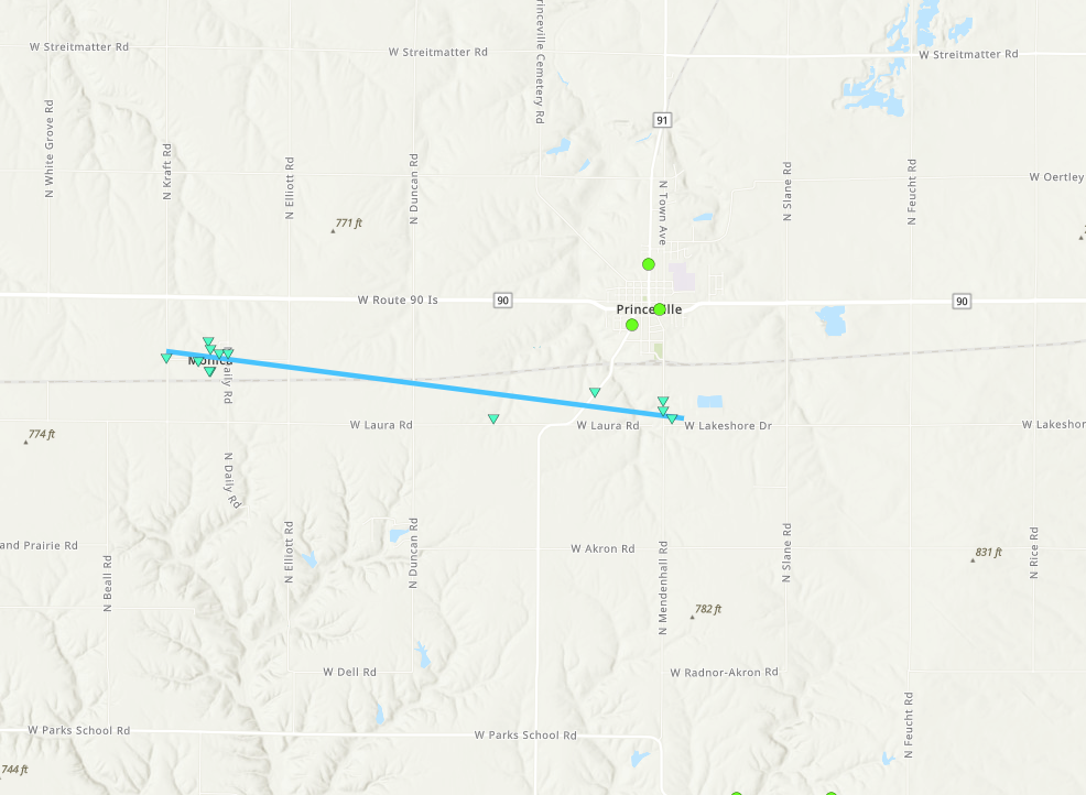
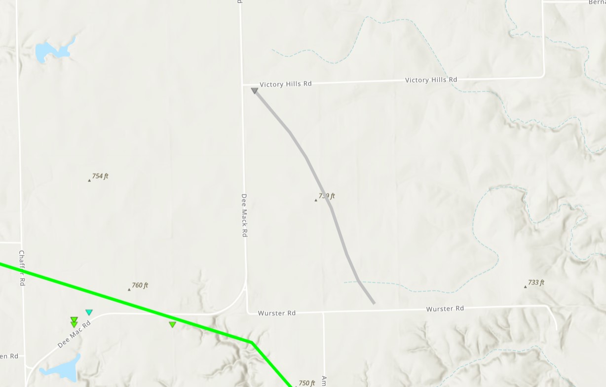
0815 PM Tornado Monica 40.92N 89.83W
07/15/2024 Peoria IL NWS Storm Survey
EF0, max wind speed 80 mph, length 4.26
miles, width 80 yards. A couple of roofs and
trees were damaged in Monica before the
tornado tracked east-southeast. It damaged
several large trees along the path before
dissipating along West Lake Shore Drive
south of Princeville.
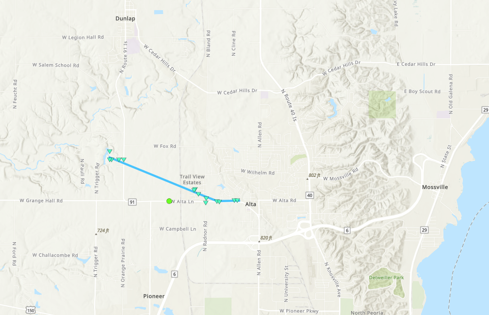
0822 PM Tornado 3 S Dunlap 40.83N 89.68W
07/15/2024 Peoria IL NWS Storm Survey
EF0, max wind speed 85 mph, path length 2.6
miles, max width 100 yards. Touched down
along W. Gun Club Rd. near the intersection
with Route 91, damaging several trees. It
progressed southeast and damaged homes and
trees in the Trail View Estates
neighborhood, before dissipating as it
reached Alta.
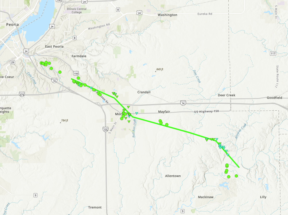
0836 PM Tornado 3 ESE East Peoria 40.65N 89.53W
07/15/2024 Tazewell IL NWS Storm Survey
NWS Damage Survey determined a tornado
developed SE of East Peoria and progressed
through Morton toward Makinaw before
dissipating.
0850 PM Non-Tstm Wnd Gst 3 E Toluca 41.00N 89.07W
07/15/2024 M65 MPH Marshall IL Mesonet
Mesonet station DVI03891 Toluca.
0855 PM Non-Tstm Wnd Gst 1 NNE Eureka 40.73N 89.27W
07/15/2024 M42 MPH Woodford IL Mesonet
Mesonet station CW1740 Eureka.
0949 PM Non-Tstm Wnd Gst 1 ENE Bloomington 40.48N 88.98W
07/15/2024 M60 MPH McLean IL Mesonet
Mesonet station CW3379 Bloomington.
1038 PM Hail 2 N Canton 40.58N 90.03W
07/15/2024 E0.75 Inch Fulton IL Public
Report from mPING: Dime (0.75 in.).
1002 PM Funnel Cloud 1 W Urbana 40.11N 88.22W
07/15/2024 Champaign IL Public
1035 PM Flood Lewistown 40.40N 90.16W
07/15/2024 Fulton IL Public
Report from mPING: River/Creek overflowing;
Cropland/Yard/Basement Flooding.
1035 PM Flash Flood Canton 40.56N 90.04W
07/15/2024 Fulton IL Emergency Mngr
Emergency manager reported flash flooding
over much of Fulton county with several
ditches and roads water logged.
1215 AM Flash Flood 3 S Cuba 40.46N 90.19W
07/16/2024 Fulton IL Emergency Mngr
Water flowing over route 97 between Cuba and
Fiatt.
1225 AM Flash Flood 2 SW Cuba 40.48N 90.22W
07/16/2024 Fulton IL Emergency Mngr
Roadway damage along IL-95 due to flash
flooding.
0145 AM Flash Flood 2 SW Lewistown 40.38N 90.17W
07/16/2024 Fulton IL Emergency Mngr
US-24 south of Lewistown closed due to flash
flooding.
0830 AM Flash Flood 3 SSE Dunfermline 40.46N 90.01W
07/16/2024 Fulton IL Emergency Mngr
Old Weaver Rd. closed near Buckheart Creek
due to flash flooding.
0900 AM Flash Flood 1 NW Marietta 40.52N 90.41W
07/16/2024 Fulton IL Public
Road washed out near Marietta. Social media
report. Time estimated.
0900 AM Flash Flood 3 S Bryant 40.43N 90.09W
07/16/2024 Fulton IL Emergency Mngr
Bethel Rd. washed out near Rattlesnake
Branch. Time estimated.
&&
$$
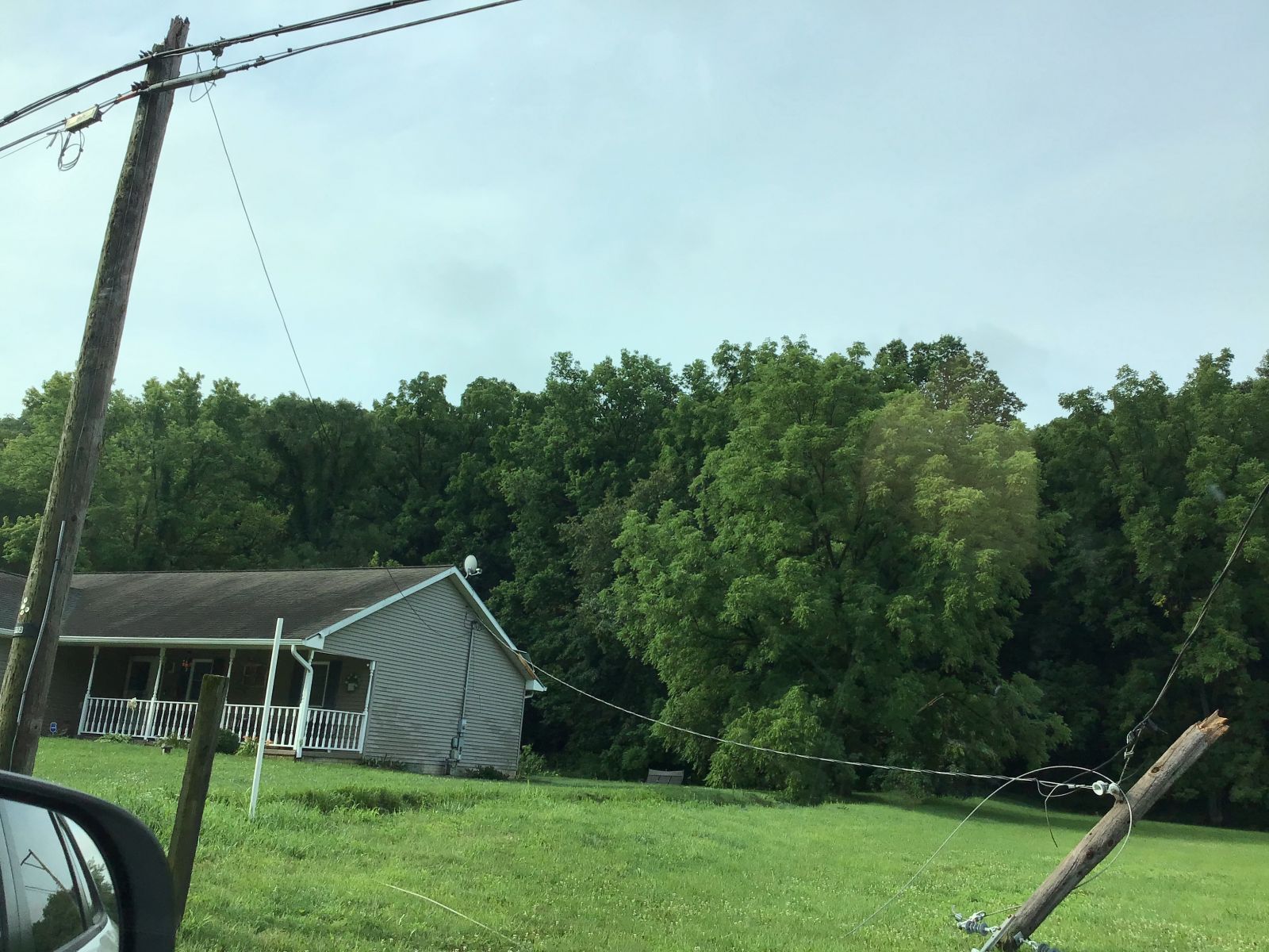
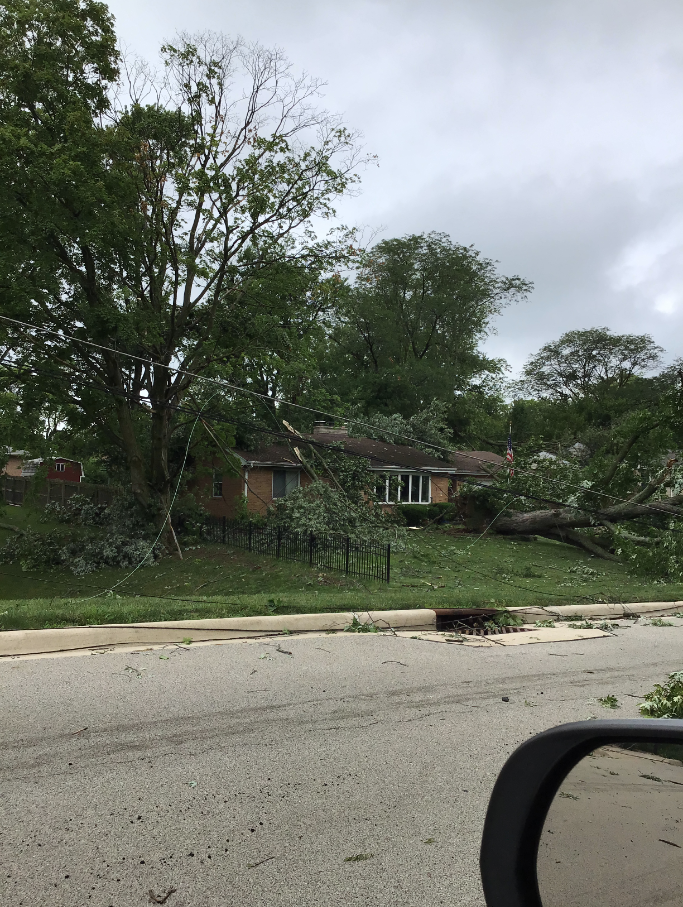
Photos & Video
Header
 |
 |
.jpg) |
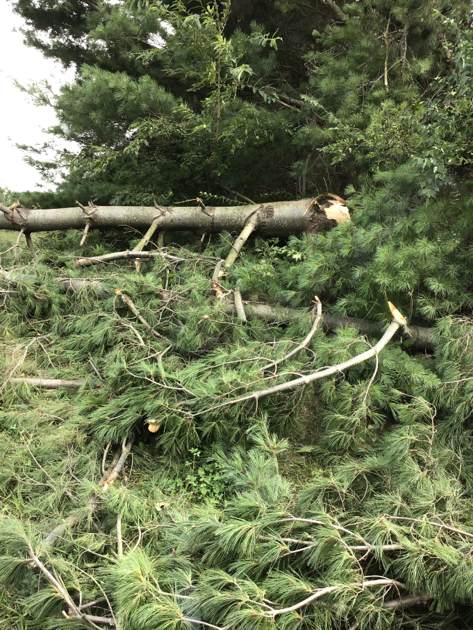 |
| Wind Damage in Peoria, IL (NWS Survey) |
Tornado damage in Morton, IL with wind speeds estimated at 85 mph (NWS Survey) |
Damage to a house west of Alta, IL (NWS Survey) |
Hardwood trees snapped near Danvers, IL from wind damage (NWS Survey) |
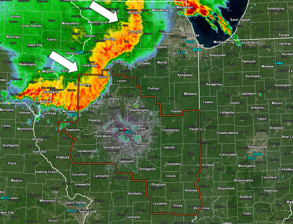
Radar
Header
 |
 |
 |
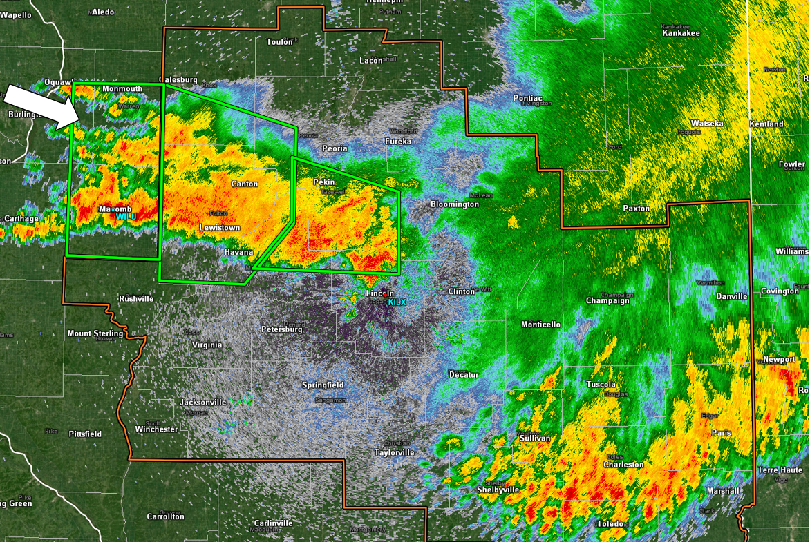 |
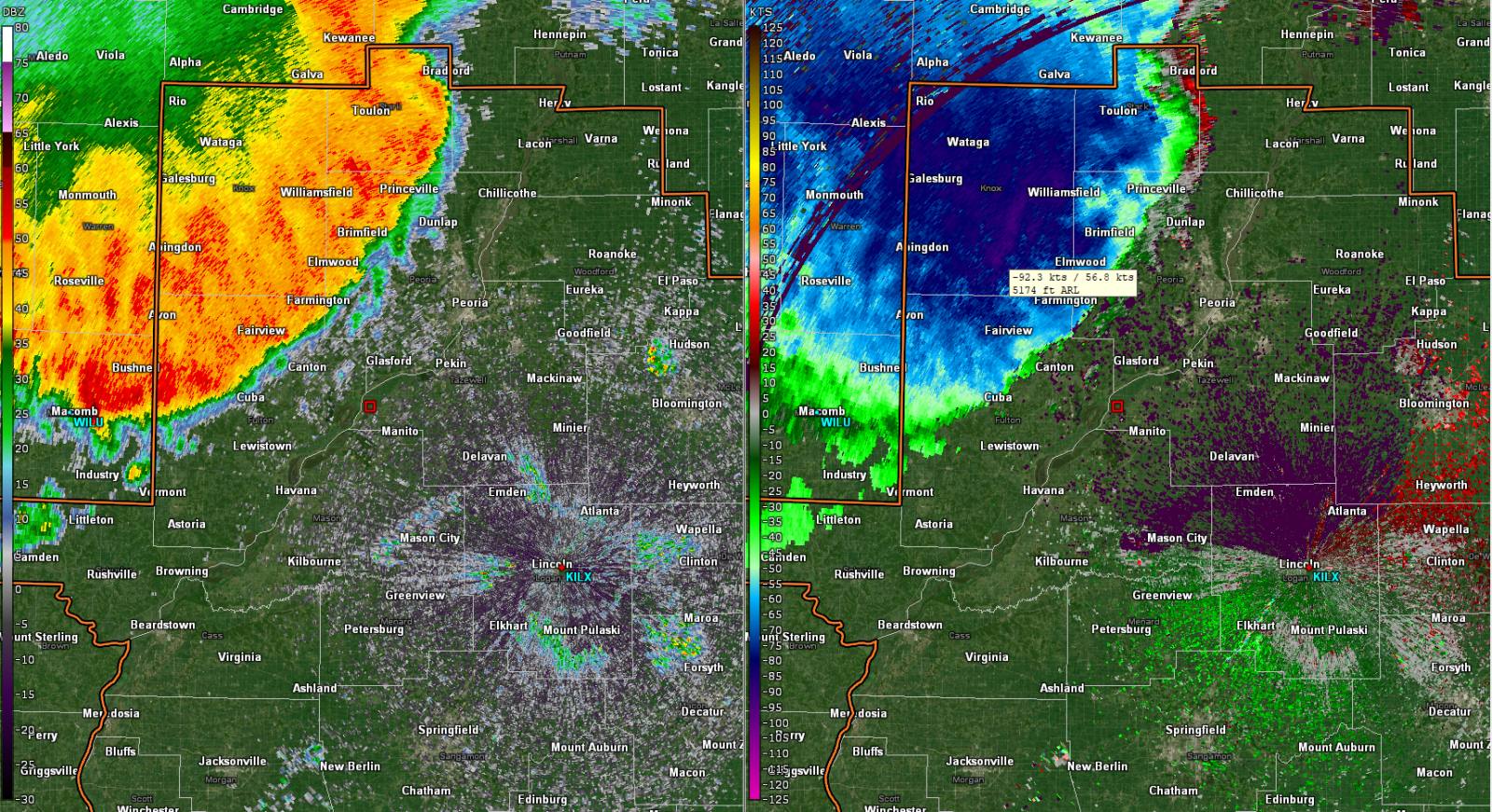
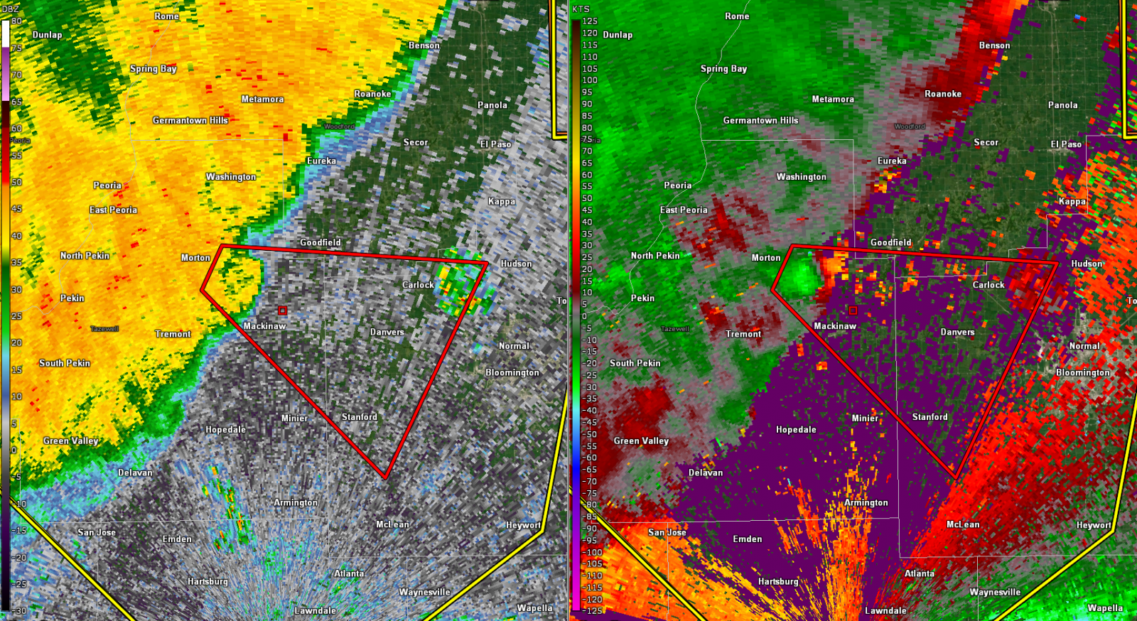
| KILX Base Reflectivity Jul 15 at 8:12 pm CDT showing the derecho surging east-southeast. The line of storms was moving at a speed of 50-60 mph. | KILX Base Reflectivity (left) & Base Velocity (right) Jul 15 at 8:17 pm CDT showing samples of wind speeds 3-5k ft above ground level of ~90kts/100+ mph (dark blues to purples). | KILX Base Reflectivity (left) & Storm Relative Motion (right) Jul 15 at 8:48 pm CDT showing a reflectivity nub and cyclonic rotation associated with a tornado just east of Morton, IL. | KILX Base Reflectivity with Flash Flood Warnings overlayed Jul 15 at 11:19 pm CDT. Later in the event, the storms started training which resulted in repeated rounds of heavy rainfall from north of Macomb, IL to north of Lincoln, IL. |
Rain Reports
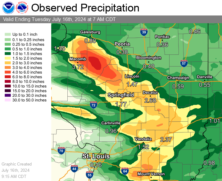
Public Information Statement
National Weather Service Lincoln IL
1155 AM CDT Wed Jul 17 2024

...JULY 15-16, 2023 RAIN REPORTS...

Location                     Amount    Time/Date       Lat/Lon

...Illinois...

...Christian County...
1 SSW Pana                   2.27 in   0600 AM 07/16   39.37N/89.09W

...Effingham County...
1 NE Watson                  2.64 in   0800 AM 07/16   39.03N/88.56W
2 NNW Dieterich              2.30 in   0800 AM 07/16   39.09N/88.39W
1 SSE Effingham              2.22 in   0700 AM 07/16   39.11N/88.53W

...Fulton County...
2 SSE Fiatt                  7.80 in   0700 AM 07/16   40.53N/90.15W
Cuba                         7.50 in   0800 AM 07/16   40.49N/90.19W
Lewistown                    6.86 in   0800 AM 07/16   40.40N/90.16W
Lewistown                    6.86 in   0220 AM 07/16   40.40N/90.16W
Bryant                       6.69 in   0800 AM 07/16   40.47N/90.09W
1 SSW Canton                 5.34 in   0700 AM 07/16   40.54N/90.04W
Avon                         4.38 in   0700 AM 07/16   40.66N/90.44W

...Jasper County...
Yale                         2.09 in   0800 AM 07/16   39.12N/88.03W

...Logan County...
New Holland                  2.82 in   0800 AM 07/16   40.18N/89.58W
Mount Pulaski                2.36 in   0450 AM 07/16   40.01N/89.28W
Mount Pulaski                2.36 in   0600 AM 07/16   40.01N/89.28W

...Macon County...
2 E Decatur                  5.50 in   0800 AM 07/16   39.84N/88.91W
Long Creek                   3.50 in   0800 AM 07/16   39.80N/88.85W
2 W Decatur                  3.45 in   0800 AM 07/16   39.84N/88.99W
2 NW Harristown              3.37 in   0800 AM 07/16   39.86N/89.11W
2 SE Latham                  2.90 in   0800 AM 07/16   39.95N/89.14W

...Mason County...
3 E Havana                   6.06 in   0800 AM 07/16   40.30N/90.00W

...Menard County...
1 E Oakford                  4.00 in   0800 AM 07/16   40.10N/89.95W
1 N Petersburg               3.06 in   0800 AM 07/16   40.03N/89.85W
3 N Salisbury                2.36 in   0600 AM 07/16   39.93N/89.80W

...Moultrie County...
Sullivan                     3.70 in   0700 AM 07/16   39.60N/88.61W

...Peoria County...
2 NE Alta                    2.75 in   0800 AM 07/16   40.84N/89.61W

...Sangamon County...
Grandview                    4.00 in   0800 AM 07/16   39.82N/89.62W
2 W Riverton                 2.98 in   0800 AM 07/16   39.85N/89.58W
1 WSW Sherman                2.50 in   0600 AM 07/16   39.89N/89.62W
Williamsville                2.40 in   0800 AM 07/16   39.95N/89.55W
4 SSE Southern View          2.04 in   0800 AM 07/16   39.71N/89.61W
Pawnee                       2.00 in   0800 AM 07/16   39.59N/89.58W

...Shelby County...
3 S Moweaqua                 2.64 in   0600 AM 07/16   39.59N/89.02W
1 ENE Shelbyville            2.30 in   0800 AM 07/16   39.41N/88.80W
1 N Windsor                  2.17 in   0600 AM 07/16   39.45N/88.60W

...Tazewell County...
3 S Kingston Mines           2.60 in   0800 AM 07/16   40.51N/89.78W

Observations are collected from a variety of sources with varying
equipment and exposures. We thank all volunteer weather observers
for their dedication. Not all data listed are considered official.

$$
Additional Information
The Forecast
 |
 |
 |
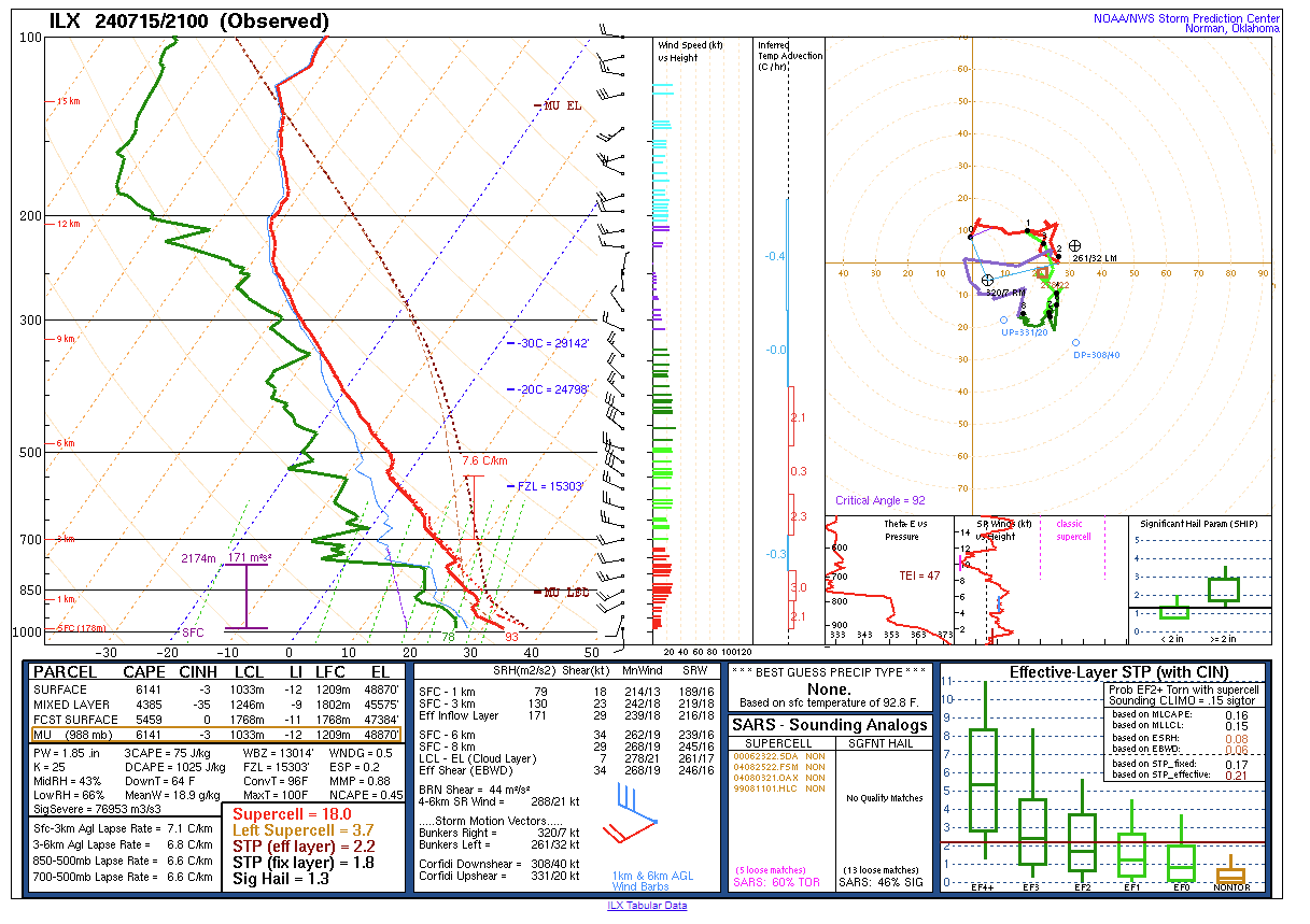 |
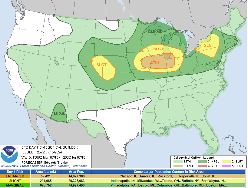
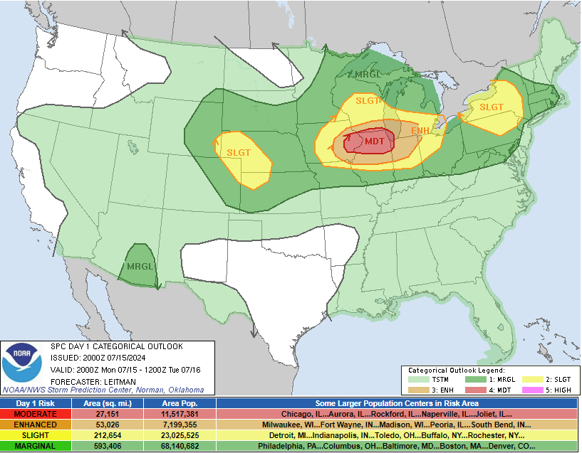
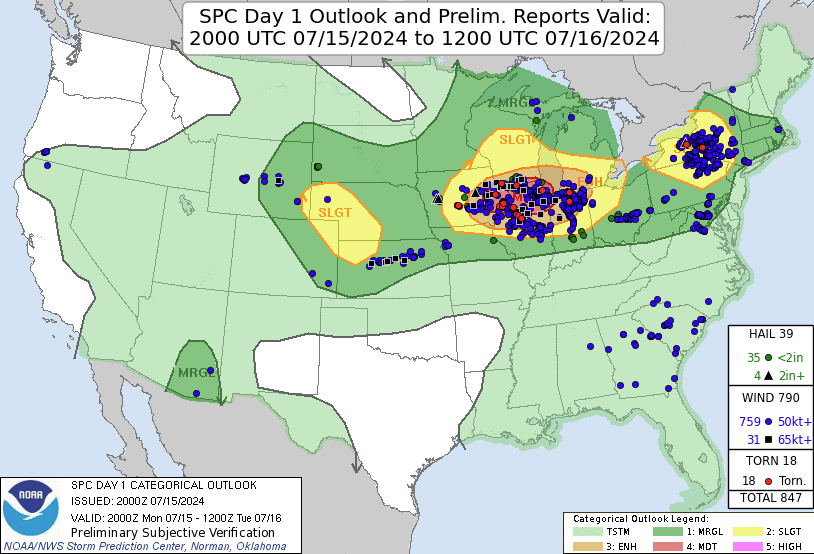
| SPC Day 1 Categorical Outlook (Jul 15, 13Z/7am) | SPC Day 1 Categorical Outlook (Jul 15, 20Z/3 pm) | SPC Day 1 Categorical Outlook with Preliminary Storm Reports | KILX Jul 15 21Z/4 pm CDT Special Sounding |
Summaries from other NWS Offices
 |
Media use of NWS Web News Stories is encouraged! Please acknowledge the NWS as the source of any news information accessed from this site. |
|