Overview
|
A mesoscale convective complex was the focus for severe thunderstorm development during the afternoon and early evening of May 20, 2025. Supercell thunderstorms developed in western IL around 1 PM and quickly became severe with golf ball to tennis ball sized hail reported over parts of Morgan and Sangamon counties. The storms continued to press into eastern IL by late afternoon. Numerous reports of large hail and wind damage were reported. Trained spotters and NWS storm damage surveys confirmed 6 weak tornadoes occurred. |
Tornadoes
Select a tornado from the table to zoom into the track and view more information. The default table view is limited to 8 tracks, but can be scrolled by a mouse wheel or dynamically expanded. Additionally, the table can fill the entire window by clicking the small circular expanding arrow icon at the very top right of the table and returned to its original size by clicking the button again. The side information panel that opens over the map can be closed using the "X" on the upper right corner of the pop-up. Zoom into the map and click damage points to see detailed information and pictures from the surveys.
|
NOTE: times shown below are local to your device's time zone. |

The Enhanced Fujita (EF) Scale classifies tornadoes into the following categories:
| EF0 Weak 65-85 mph |
EF1 Moderate 86-110 mph |
EF2 Significant 111-135 mph |
EF3 Severe 136-165 mph |
EF4 Extreme 166-200 mph |
EF5 Catastrophic 200+ mph |
 |
|||||
| Tornadoes that fail to impact any ratable structures on the EF-Scale are rated EF-Unknown (EF-U) | |||||
Photos & Video
Header
 |
 |
 |
 |
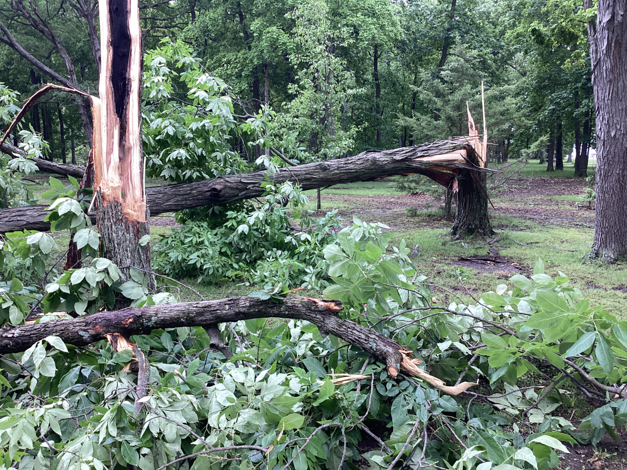
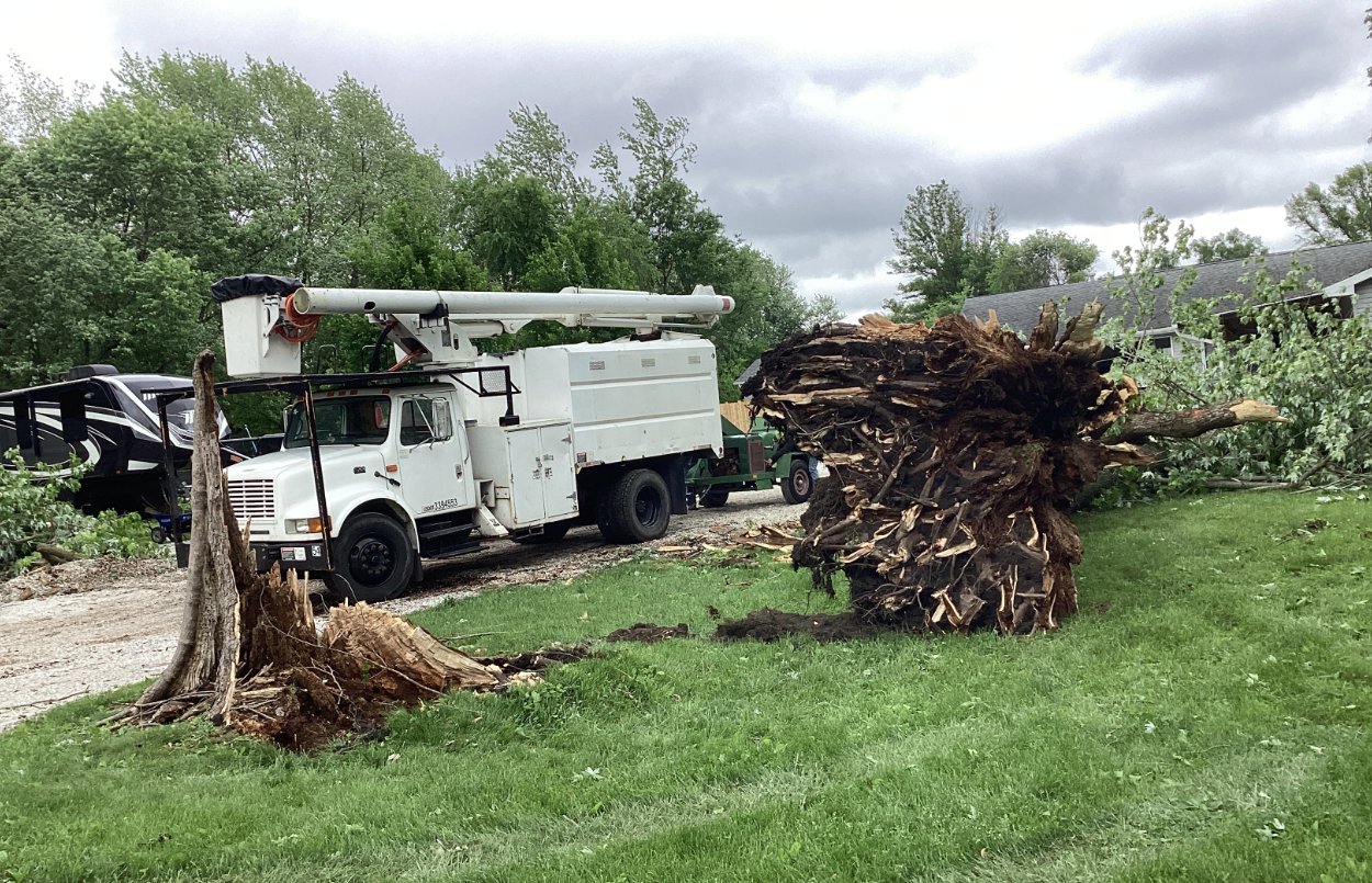
| Tornado damage south of Potomac (NWS) |
Tornado damage south of Gerald (NWS) |
Straight-line wind damage in Westville (NWS) |
Large hail near Latham (Logan Co. EMA) |
Radar
Header
 |
 |
||
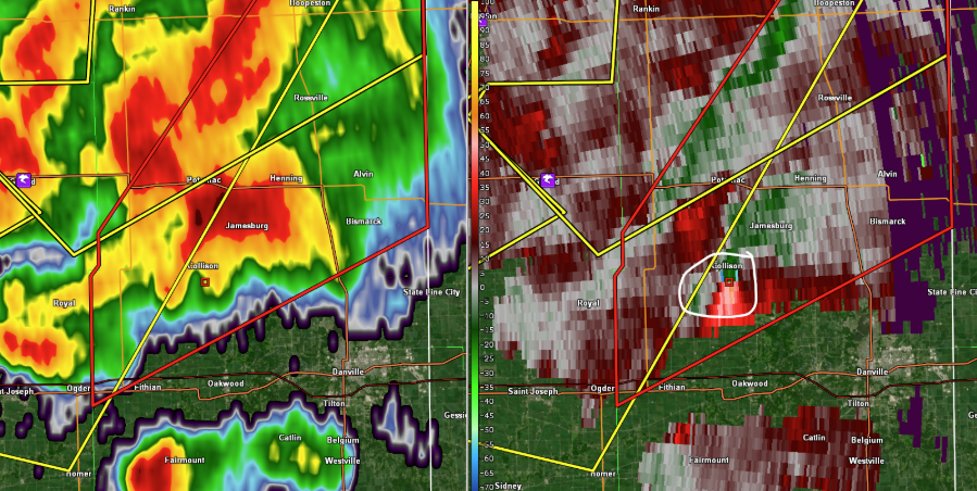
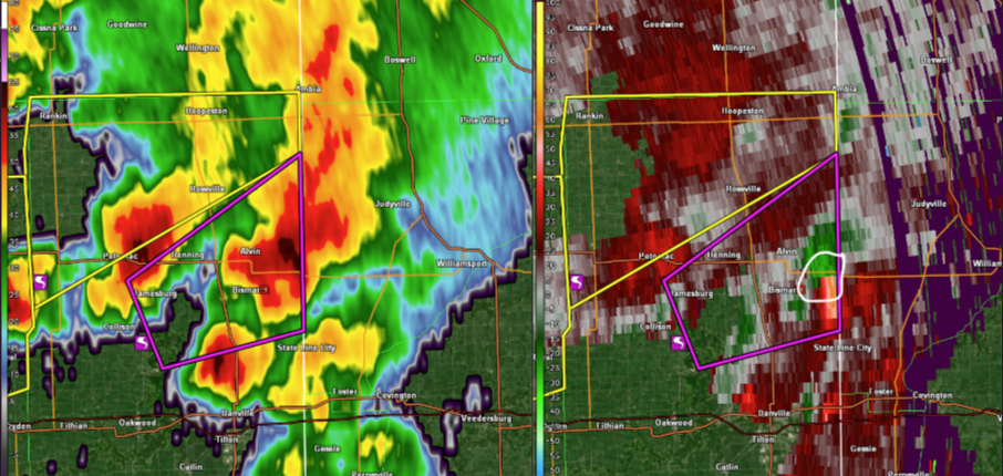
| Radar reflectivity (left) and storm relative motion (right) at 530 PM CDT showing rotation south of Collison | Radar reflectivity (left) and storm relative motion (right) at 542 PM CDT showing rotation east of Bismarck | Caption | Caption |
Storm Reports
Tornado Information

...NWS Damage Survey for 05/20/2025 Tornado Event...

.Update to the Oakland Tornado...Changed from an EFU to an EF0,
increased wind to 65 mph, added length of 2.85 miles, and start
and end points.

.Oakland Tornado...

Rating:                 EF0
Estimated Peak Wind:    65 mph
Path Length /statute/:  2.85 miles
Path Width /maximum/:   20 yards
Fatalities:             0
Injuries:               0

Start Date:             05/20/2025
Start Time:             02:15 PM CDT
Start Location:         1 WNW Oakland / Coles County / IL
Start Lat/Lon:          39.6602 / -88.0371

End Date:               05/20/2025
End Time:               02:19 PM CDT
End Location:           3 N Oakland / Douglas County / IL
End Lat/Lon:            39.6984 / -88.0168

Survey Summary:
The tornado touchdown on the northwest side of Oakland, damaging
tree branches. It moved to the northeast through a grove of trees
and then across farm fields of northeast Coles county. It
remained in the farm fields and did not do any other damage as it
moved into southeast Douglas county and then lifted east of
Walnut Point State Park.

.Latham Torndao...

Rating:                 EFU
Estimated Peak Wind:    60 mph
Path Length /statute/:  1.11 miles
Path Width /maximum/:   30 yards
Fatalities:             0
Injuries:               0

Start Date:             05/20/2025
Start Time:             03:27 PM CDT
Start Location:         2 S Latham / Logan County / IL
Start Lat/Lon:          39.9354 / -89.1677

End Date:               05/20/2025
End Time:               03:28 PM CDT
End Location:           2 SSE Latham / Logan County / IL
End Lat/Lon:            39.9399 / -89.1475

Survey Summary:
A spotter reported a rain-wrapped tornado south of Latham along
2300 Ave. No damage was reported.

.Gerald Tornado...

Rating:                 EF0
Estimated Peak Wind:    85 mph
Path Length /statute/:  0.92 miles
Path Width /maximum/:   30 yards
Fatalities:             0
Injuries:               0

Start Date:             05/20/2025
Start Time:             04:57 PM CDT
Start Location:         4 N Royal / Champaign County / IL
Start Lat/Lon:          40.2488 / -87.9699

End Date:               05/20/2025
End Time:               04:59 PM CDT
End Location:           3 S Penfield / Champaign County / IL
End Lat/Lon:            40.2556 / -87.955

Survey Summary:
The tornado touched down about 1.5 miles southwest of Gerald
along County Rd 2000 E where it did some tree damage. It then
damaged an outbuilding along County Rd 2600, where it removed
about a third of the roof and tossed it to the northeast.
The tornado then dissipated a short time later.

.Armstrong-Potomac Tornado...

Rating:                 EF1
Estimated Peak Wind:    90 mph
Path Length /statute/:  5.05 miles
Path Width /maximum/:   80 yards
Fatalities:             0
Injuries:               0

Start Date:             05/20/2025
Start Time:             05:06 PM CDT
Start Location:         3 SSW Armstrong / Vermilion County / IL
Start Lat/Lon:          40.2634 / -87.8937

End Date:               05/20/2025
End Time:               05:10 PM CDT
End Location:           2 S Potomac / Vermilion County / IL
End Lat/Lon:            40.2715 / -87.7995

Survey Summary:
The tornado touched down about 3 miles south of Armstrong along N
270 East Rd where it damaged some trees.  It moved east and
snapped two power poles along N 650 East Rd. I was then caught on
video approaching Potomac Collison Rd before it snapped or
uprooted around 12 large trees, roughly 2 foot diameter. The
tornado dissipated shortly there-after to the east of that
residence.

.Collison Tornado...

Rating:                 EF0
Estimated Peak Wind:    70 mph
Path Length /statute/:  6.95 miles
Path Width /maximum/:   40 yards
Fatalities:             0
Injuries:               0

Start Date:             05/20/2025
Start Time:             05:06 PM CDT
Start Location:         2 SW Collison / Vermilion County / IL
Start Lat/Lon:          40.202 / -87.8439

End Date:               05/20/2025
End Time:               05:15 PM CDT
End Location:           4 ENE Collison / Vermilion County / IL
End Lat/Lon:            40.243 / -87.7294

Survey Summary:
The weak EF-0 tornado touched down about 4 miles southwest of
Collison where it did tree damage. It moved east and was video
taped by spotters as it passed about 2 miles southeast of
Collison, where it did more tree damage. The tornado progressed
northeast through the Horseshoe Bottom Nature Preserve then did
additional tree damage along E 200 North Rd before dissipating.

.Bismark Tornado...

Rating:                 EF0
Estimated Peak Wind:    75 mph
Path Length /statute/:  1.76 miles
Path Width /maximum/:   30 yards
Fatalities:             0
Injuries:               0

Start Date:             05/20/2025
Start Time:             05:39 PM CDT
Start Location:         3 ENE Bismarck / Vermilion County / IL
Start Lat/Lon:          40.2684 / -87.5532

End Date:               05/20/2025
End Time:               05:41 PM CDT
End Location:           4 ESE Alvin / Vermilion County / IL
End Lat/Lon:            40.2858 / -87.5304

Survey Summary:
The tornado touched down about 3 miles east of Bismark and
produced some tree damage along E 2500 North Rd. It progressed to
the northeast where it damaged the roof of an outbuilding before
dissipating before reaching the Indiana State Line.

&&

EF Scale: The Enhanced Fujita Scale classifies tornadoes into the
following categories:

EF0.....65 to 85 mph
EF1.....86 to 110 mph
EF2.....111 to 135 mph
EF3.....136 to 165 mph
EF4.....166 to 200 mph
EF5.....>200 mph

NOTE:
The information in this statement is preliminary and subject to
change pending final review of the events and publication in
NWS Storm Data.
Preliminary Local Storm Reports
Preliminary Local Storm Report...Summary
National Weather Service Lincoln IL
1008 PM CDT Tue May 20 2025

..TIME...   ...EVENT...      ...CITY LOCATION...     ...LAT.LON...
..DATE...   ....MAG....      ..COUNTY LOCATION..ST.. ...SOURCE....
            ..REMARKS..

0124 PM     Hail             Jacksonville            39.73N 90.23W
05/20/2025  E1.25 Inch       Morgan             IL   Public

            Quarter to half dollar hail, relayed by
            media.

0124 PM     Hail             Jacksonville            39.73N 90.23W
05/20/2025  M2.00 Inch       Morgan             IL   Trained Spotter


0124 PM     Tstm Wnd Gst     Jacksonville            39.73N 90.23W
05/20/2025  M60 MPH          Morgan             IL   Trained Spotter

            Measured gust, no damage noted.

0147 PM     Hail             3 SSE Prentice          39.82N 90.02W
05/20/2025  M2.50 Inch       Morgan             IL   Broadcast Media

            Time estimated from radar.

0156 PM     Hail             4 NNW Berlin            39.81N 89.93W
05/20/2025  M2.00 Inch       Sangamon           IL   Storm Chaser


0158 PM     Funnel Cloud     1 N Alexander           39.74N 90.04W
05/20/2025                   Morgan             IL   Storm Chaser


0202 PM     Tstm Wnd Dmg     3 E Knoxville           40.91N 90.23W
05/20/2025                   Knox               IL   Broadcast Media

            Tree down on I-74 blocking eastbound right
            lane.

0215 PM     Funnel Cloud     Newman                  39.80N 87.98W
05/20/2025                   Douglas            IL   Broadcast Media


0222 PM     Tornado          Oakland                 39.66N 88.03W
05/20/2025                   Coles              IL   Broadcast Media

            Corrects previous funnel cloud report from
            Oakland. Report from earlier this afternoon.
            Several funnel cloud pics received, and
            video of a brief touchdown.

0225 PM     Tstm Wnd Dmg     Peoria                  40.72N 89.59W
05/20/2025                   Peoria             IL   Trained Spotter

            2-3 diameter tree limbs blown down.

0228 PM     Hail             2 S Curran              39.71N 89.77W
05/20/2025  M1.00 Inch       Sangamon           IL   Storm Chaser

            Time based on radar.

0230 PM     Hail             3 W Curran              39.73N 89.82W
05/20/2025  E1.00 Inch       Sangamon           IL   Public

            Report from mPING: Quarter (1.00 in.).

0232 PM     Hail             1 N Curran              39.76N 89.77W
05/20/2025  E1.50 Inch       Sangamon           IL   Public


0232 PM     Tstm Wnd Dmg     1 N Alta                40.83N 89.63W
05/20/2025                   Peoria             IL   Trained Spotter

            3-4 diameter tree limbs blown down.

0233 PM     Hail             1 NNE Curran            39.76N 89.76W
05/20/2025  E1.25 Inch       Sangamon           IL   Public

            Quarter to half dollar size hail at
            Centennial Park.

0234 PM     Hail             3 SW Capital Airport    39.81N 89.71W
05/20/2025  M1.50 Inch       Sangamon           IL   Trained Spotter

            Delayed report. Ping pong sized hail near
            interchange of Highway 97 and Highway 4.

0240 PM     Hail             3 W Leland Grove        39.78N 89.73W
05/20/2025  E1.50 Inch       Sangamon           IL   Trained Spotter

            West side of Springfield near the
            intersection of Archer Elevator and
            Greenbriar Rds.

0241 PM     Hail             2 W Springfield         39.80N 89.69W
05/20/2025  M1.25 Inch       Sangamon           IL   Trained Spotter


0245 PM     Flood            1 S Cantrall            39.92N 89.67W
05/20/2025                   Sangamon           IL   Law Enforcement

            Water over Illinois 29 at Gabbert Rd.

0245 PM     Hail             Marquette Heights       40.62N 89.60W
05/20/2025  M1.00 Inch       Tazewell           IL   Public

            Relayed by media. Time estimated from radar.

0256 PM     Hail             2 N Leland Grove        39.80N 89.69W
05/20/2025  E0.75 Inch       Sangamon           IL   Public

            Report from mPING: Dime (0.75 in.).

0321 PM     Funnel Cloud     2 NW Rantoul            40.32N 88.18W
05/20/2025                   Champaign          IL   Broadcast Media


0325 PM     Hail             1 W Fisher              40.31N 88.36W
05/20/2025  E0.75 Inch       Champaign          IL   Public

            Report from mPING: Dime (0.75 in.).

0329 PM     Hail             5 S Mount Pulaski       39.94N 89.28W
05/20/2025  M1.25 Inch       Logan              IL   Public

            Photo of hail slightly larger than quarters.

0330 PM     Funnel Cloud     3 SW Kenney             40.08N 89.12W
05/20/2025                   De Witt            IL   Emergency Mngr


0333 PM     Tornado          2 S Latham              39.94N 89.16W
05/20/2025                   Logan              IL   Trained Spotter

            Rain wrapped tornado reported. Relayed by
            EMA.

0335 PM     Hail             1 S Latham              39.95N 89.16W
05/20/2025  M1.75 Inch       Logan              IL   Emergency Mngr


0345 PM     Hail             Forsyth                 39.93N 88.96W
05/20/2025  M1.00 Inch       Macon              IL   Broadcast Media


0403 PM     Hail             1 N Cisco               40.03N 88.73W
05/20/2025  E1.00 Inch       Piatt              IL   Broadcast Media


0410 PM     Hail             Fisher                  40.32N 88.35W
05/20/2025  M1.00 Inch       Champaign          IL   Trained Spotter


0442 PM     Hail             Mahomet                 40.19N 88.40W
05/20/2025  M1.00 Inch       Champaign          IL   Emergency Mngr


0444 PM     Funnel Cloud     Gifford                 40.31N 88.02W
05/20/2025                   Champaign          IL   Emergency Mngr

            Funnel cloud reports from EMA and media.

0445 PM     Hail             Mahomet                 40.19N 88.40W
05/20/2025  M2.00 Inch       Champaign          IL   Public

            relayed by media.

0445 PM     Hail             Mahomet                 40.19N 88.40W
05/20/2025  M1.50 Inch       Champaign          IL   Trained Spotter


0501 PM     Funnel Cloud     2 S Penfield            40.28N 87.95W
05/20/2025                   Champaign          IL   Emergency Mngr


0504 PM     Tornado          3 SW Armstrong          40.28N 87.92W
05/20/2025                   Vermilion          IL   Emergency Mngr

            Video on social media.

0510 PM     Tstm Wnd Dmg     2 SSW Potomac           40.28N 87.81W
05/20/2025                   Vermilion          IL   Broadcast Media

            Tree and power line damage along
            Potomac-Collison Rd. north of county road
            2800N.

0519 PM     Tornado          2 ESE Collison          40.21N 87.77W
05/20/2025                   Vermilion          IL   Broadcast Media

            Video and photos of tornado.

0557 PM     Funnel Cloud     5 N Danville            40.21N 87.63W
05/20/2025                   Vermilion          IL   Law Enforcement

            Relayed by EMA.

0608 PM     Tstm Wnd Dmg     1 SW Potomac            40.30N 87.81W
05/20/2025                   Vermilion          IL   Emergency Mngr

            Time estimated from radar.

0650 PM     Tstm Wnd Dmg     2 S Westville           40.02N 87.64W
05/20/2025                   Vermilion          IL   Broadcast Media

            1 to 2 foot diameter pine trees snapped.


&&
Additional Information
The Forecast
 |
 |
 |
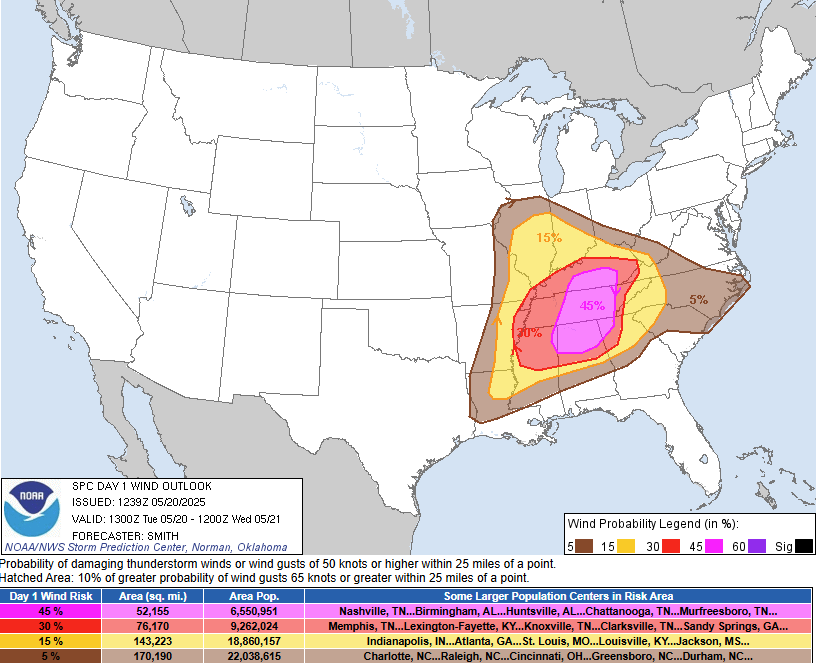 |
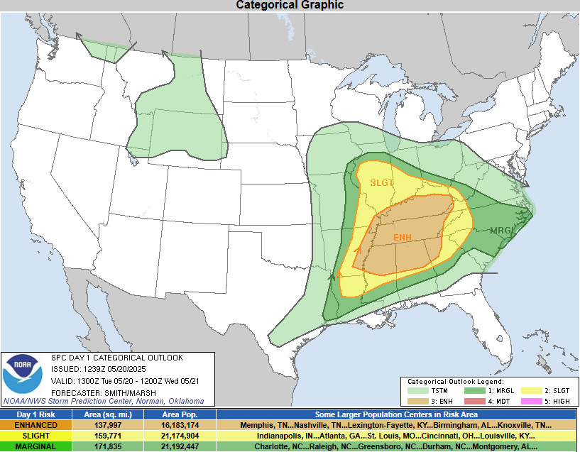
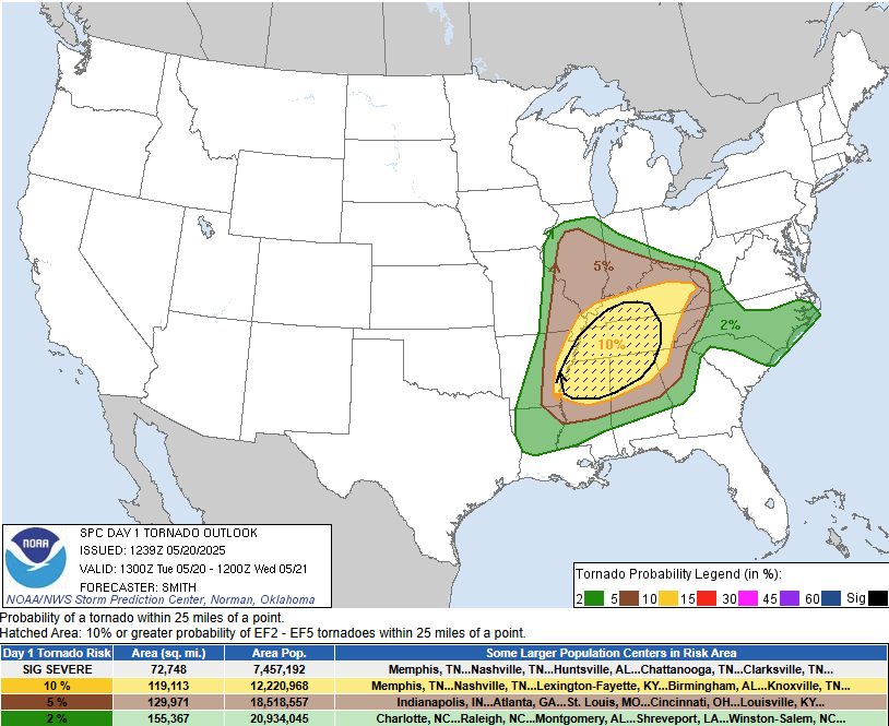
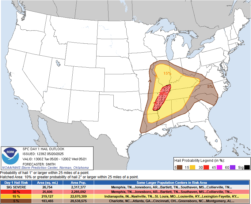
| SPC Day 1 Categorical Outlook | SPC Day 1 Tornado Outlook | SPC Day 1 Hail Outlook | SPC Day 1 Wind Outlook |
 |
|||
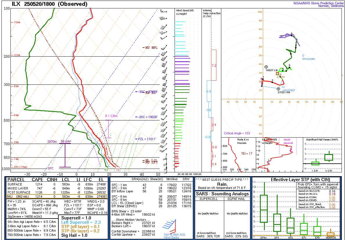
| Special 18Z sounding launched just after noon on 5/20 from Lincoln, IL |
 |
Media use of NWS Web News Stories is encouraged! Please acknowledge the NWS as the source of any news information accessed from this site. |
|

