Top 10 Weather Events of 2023
1) January 3: Eight Tornadoes
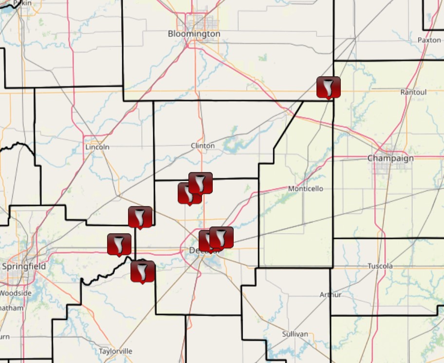
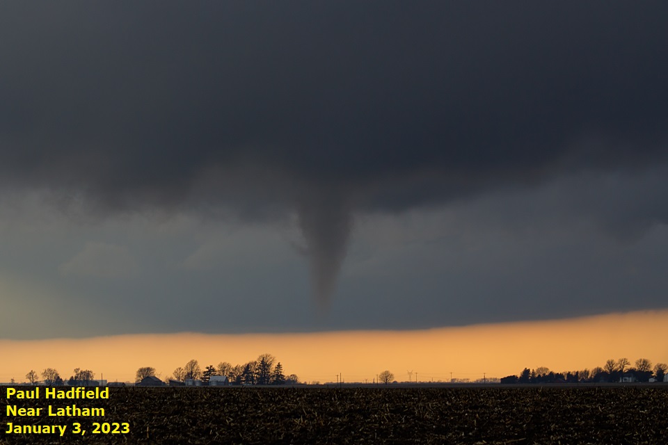
Just a little over a week after temperatures had plunged below zero for 3 consecutive days around Christmas 2022, a period of record-breaking warmth occurred across central Illinois after the start of the New Year. The high temperature on January 3rd reached 65 degrees in Peoria, 66 degrees in Lincoln, and 67 degrees in Springfield...all of which were records for the date. An area of low pressure tracking northeastward across Iowa pushed a cold front into central Illinois during the afternoon of January 3rd. The airmass ahead of the front became moderately unstable thanks to surface temperatures climbing into the lower to middle 60s and dewpoints hovering near 60 degrees. Given the instability and increasing amounts of deep-layer wind shear in association with a strong upper low approaching from the west, scattered supercell thunderstorms developed along the front during the afternoon. The storms were primarily focused in a corridor from Springfield and Taylorville northeastward to near Champaign. A total of 8 short-lived weak tornadoes touched down within this corridor, with the strongest tornadoes producing EF-1 damage near Maroa and in the Decatur area.
=============================================================================================================================
2) March 3: High Winds in East-Central Illinois
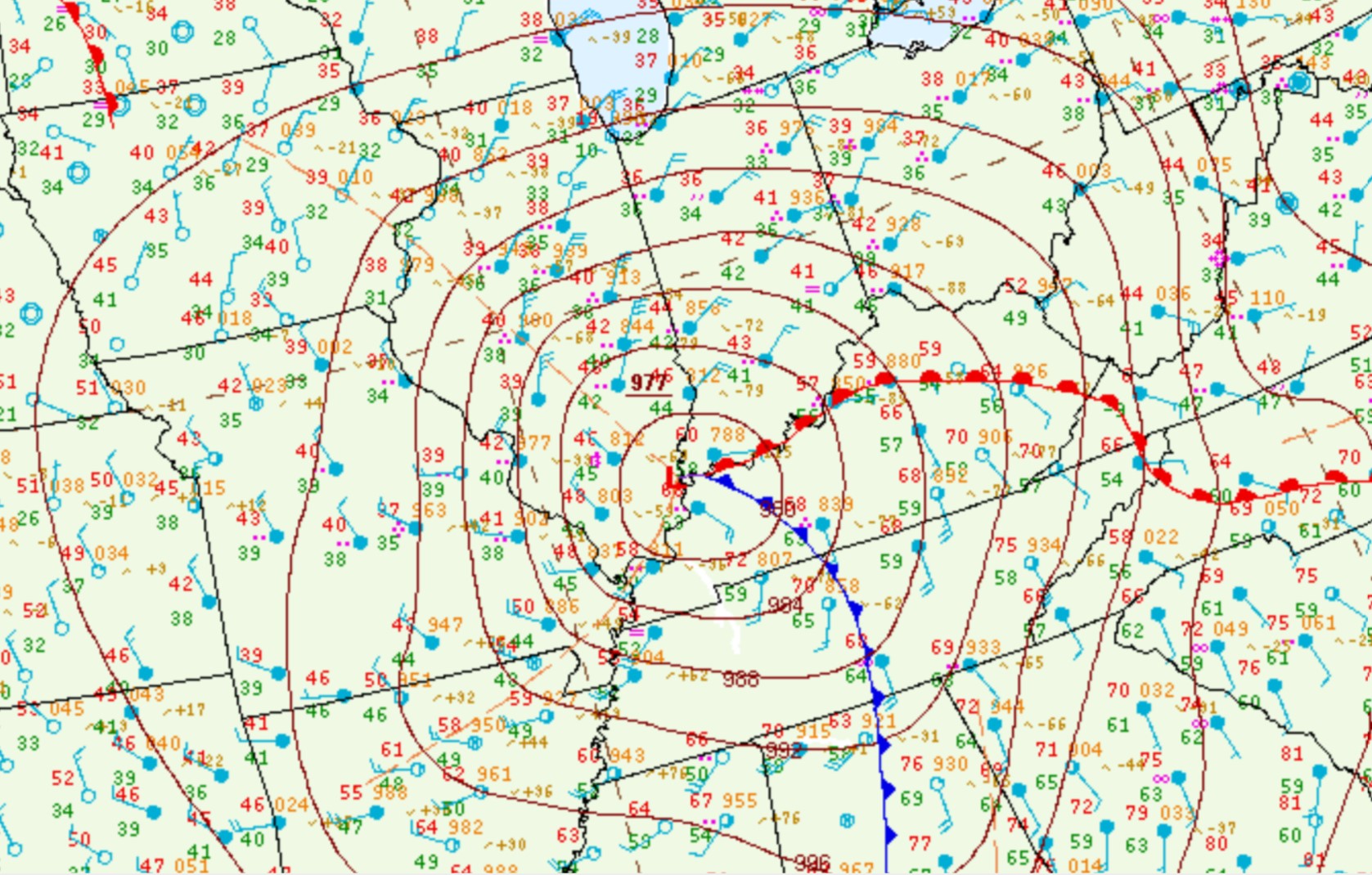
As a vigorous upper-level wave tracked eastward out of the southern Rockies, surface low pressure formed over Texas then lifted northeastward into the Ohio River Valley on March 3rd. Analysis from the evening of March 2nd showed a 991mb low over central Texas...with the low rapidly deepening to 976mb as it tracked into southern Indiana by the afternoon of March 3rd. Surface pressures of these magnitudes are rare across the Midwest and are in fact more comparable to a tropical storm or hurricane. An all-time record low barometric pressure reading of 977.7mb was established at Paducah, Kentucky and 976.0mb at Evansville, Indiana. To the north of the low track, central Illinois got battered with very strong gradient winds. Northeasterly gusts frequently topped 50 mph...with the highest gusts in excess of 60 mph focused in a corridor from Decatur and Mattoon northeastward to Champaign. The highest gust recorded was 72 mph at the Mattoon Airport. Given the high wind gusts from an unusual direction (northeast), several trees, tree branches, and power lines were downed across the area.
12PM MARCH 3, 2023 SURFACE CHART
=============================================================================================================================
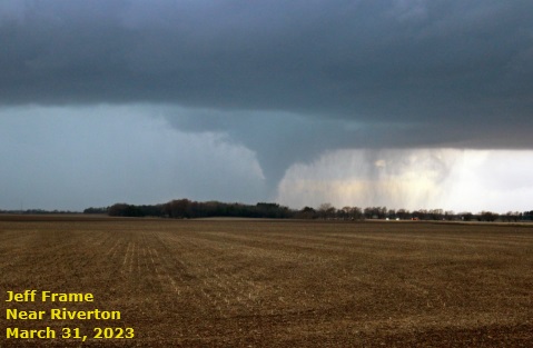
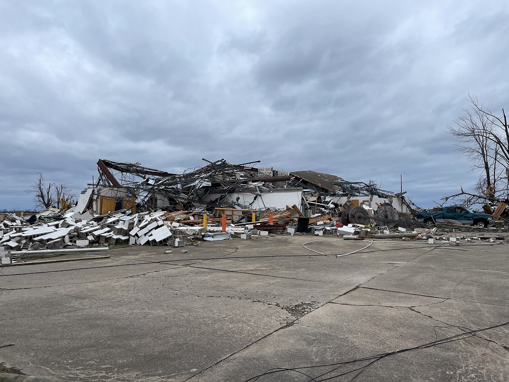
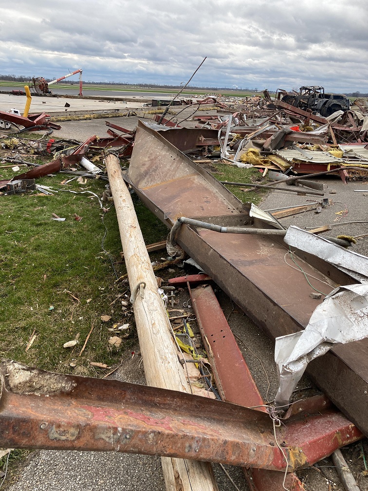
3) March 31: Tornado Outbreak
Two rounds of strong to severe thunderstorms spawned 13 tornadoes across central Illinois during the afternoon and evening of March 31st...including an EF-3 tornado that killed 3 people in Robinson in Crawford County. The first round of convection developed along a warm front lifting northeastward through the area during the afternoon. These storms were primarily very large hail-producers, with up to baseball-sized (2.75" diameter) hail being reported in the town of Banner in Fulton County. Once the warm front lifted into northern Illinois, a modestly unstable but highly sheared environment was in place during the late afternoon and evening...with CAPE values of 1500-2500J/kg and 0-6km bulk shear in excess of 70kt. As a trailing cold front approached from the west, additional supercell thunderstorms developed that produced tornadoes, very large hail, and damaging wind gusts. The cells eventually congealed into a broken line as they pushed eastward to the I-57 corridor by mid-evening. Meanwhile, a discrete supercell ahead of the line tracked south of I-70, dropping the EF-3 tornado in Crawford County.
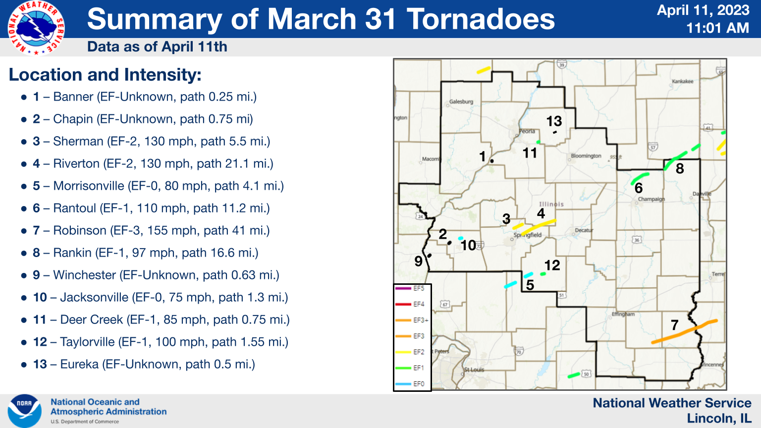
TORNADO DAMAGE NEAR ROBINSON
TORNADO DAMAGE AT THE CRAWFORD COUNTY AIRPORT
========================================================================================================
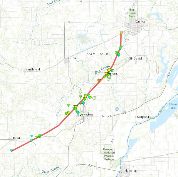
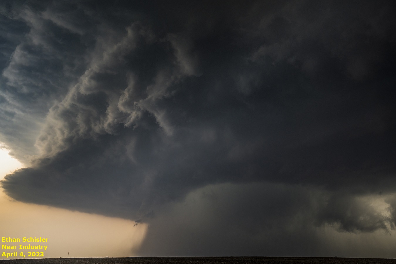
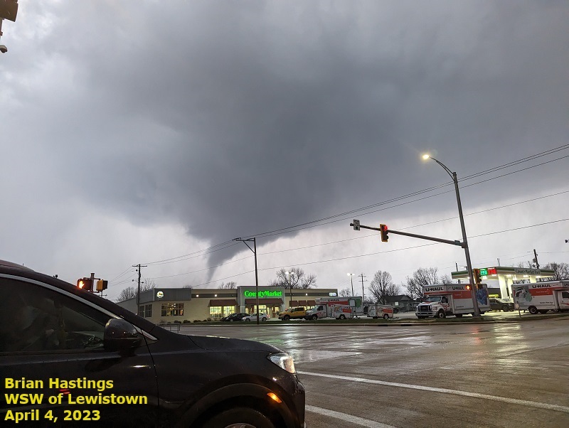
4) April 4: EF-3 Tornado in Fulton County
As a warm front lifted northward, a highly unstable and sheared environment developed across west-central Illinois during the afternoon and evening of April 4th. Despite the favorable parameters, thunderstorm activity was slow to initiate due to the lack of a forcing mechanism and the presence of low-level capping. As a subtle short-wave approached from the west and weakened the cap, a large supercell thunderstorm formed over southern McDonough County then tracked east-northeast across Fulton County. This storm produced a total of 4 tornadoes in Fulton County...including an EF-3 tornado that tracked across the northwest side of Lewistown. Very large hail was reported as well...with the largest stone measuring 4 inches in diameter in the town of Bernadotte.
LEWISTOWN TORNADO TRACK
PARENT SUPERCELL VIEWED FROM NEAR INDUSTRY, IL
TORNADO JUST SOUTHWEST OF LEWISTOWN
SOFTBALL-SIZED HAIL IN BERNADOTTE
=============================================================================================================================
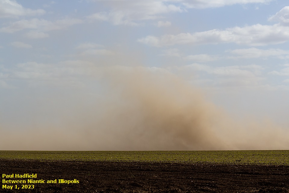
5) May 1: Dust Storm
A tight pressure gradient between a deep low centered over southeastern Ontario and a ridge axis over the Plains led to gusty northwesterly winds across central Illinois on May 1st. Under clear skies, deep-layer mixing developed as the day progressed...leading to frequent wind gusts of 40-50 mph. The peak gust observed was 54 mph at the Springfield Airport. Due to a stretch of dry weather and recent plowing of area farm fields, the strong winds were able to create areas of blowing dust with significant visibility reductions. The dust was most prevalent from near Springfield southeastward to Effingham from late morning through the afternoon. With visibility reduced to near zero in blowing dust, a 72-vehicle crash occurred on I-55 south of Springfield between mile markers 76 and 78. Eight people were killed and dozens injured in far northern Montgomery County in the Saint Louis National Weather Service County Warning Area (CWA). I-55 was closed in both directions for several hours until cleanup was completed.
=============================================================================================================================
6) June: Canadian Wildfire Smoke
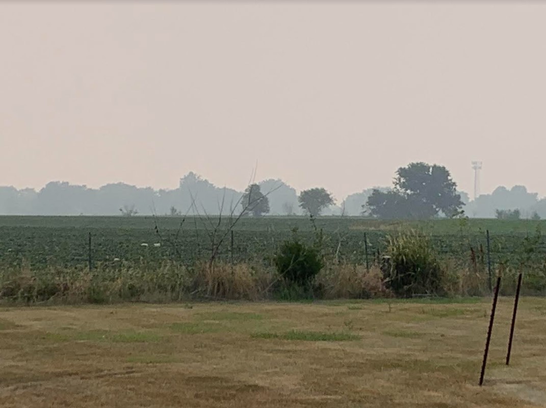
Wildfires that broke out across northern British Columbia, Alberta, and Saskatchewan during the month of May began sending smoke southeastward into parts of the Central and Eastern U.S. by early June. The smoke was primarily confined to high altitudes, which created a hazy overcast on numerous days. Occasionally enough vertical mixing occurred in the atmosphere to bring the smoke down to ground-level, which caused hazardous air quality conditions and a smoky smell to the air. Thanks to persistent upper troughing centered over eastern Canada, air quality issues plagued central Illinois for much of the month of June...peaking during the June 27th through June 29th timeframe. At that time, additional wildfires had ignited further east across Quebec...bringing a thick plume of smoke into the Great Lakes and Midwest. NWS Lincoln issued several Air Quality Alerts (AQA) in June, highlighting the need for people with breathing issues to remain indoors as much as possible. This was the first time in the history of the Lincoln office that an AQA had ever been issued.
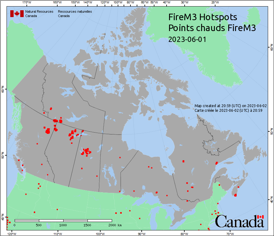
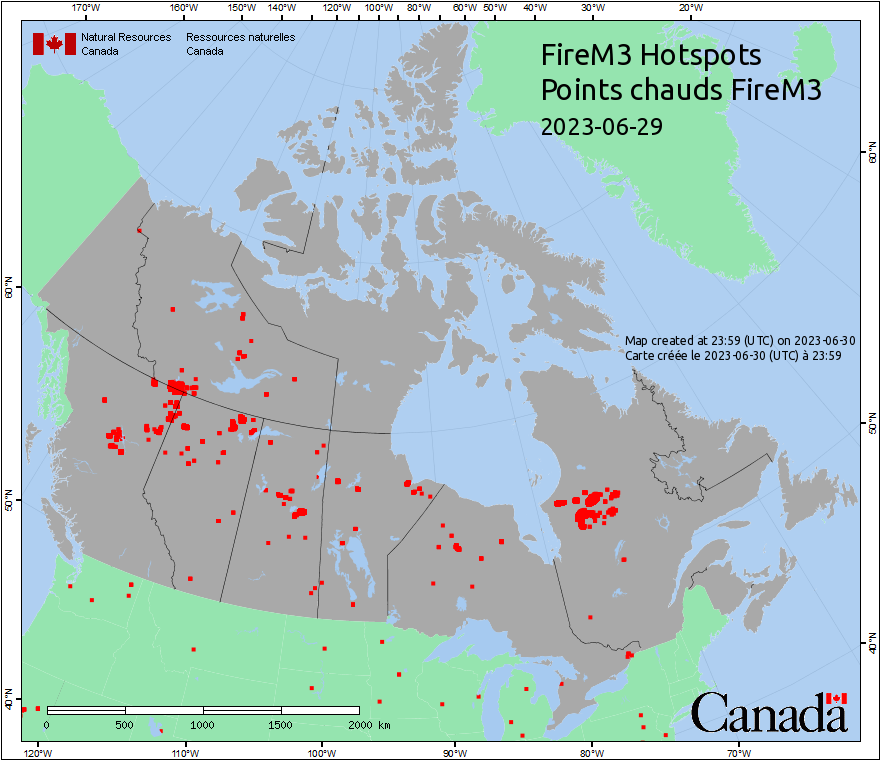
Below are two images courtesy of the Canadian Wildland Fire Information System. The red dots are "hotspots" detected by infrared satellite. After applying a quality control method to remove known industrial sources, the remaining spots indicate ongoing wildfires. Note how the number of fires increased drastically during the month of June, with more fires developing further east by the end of the month.
JUNE 1 WILDFIRES JUNE 29 WILDFIRES
 |
 |
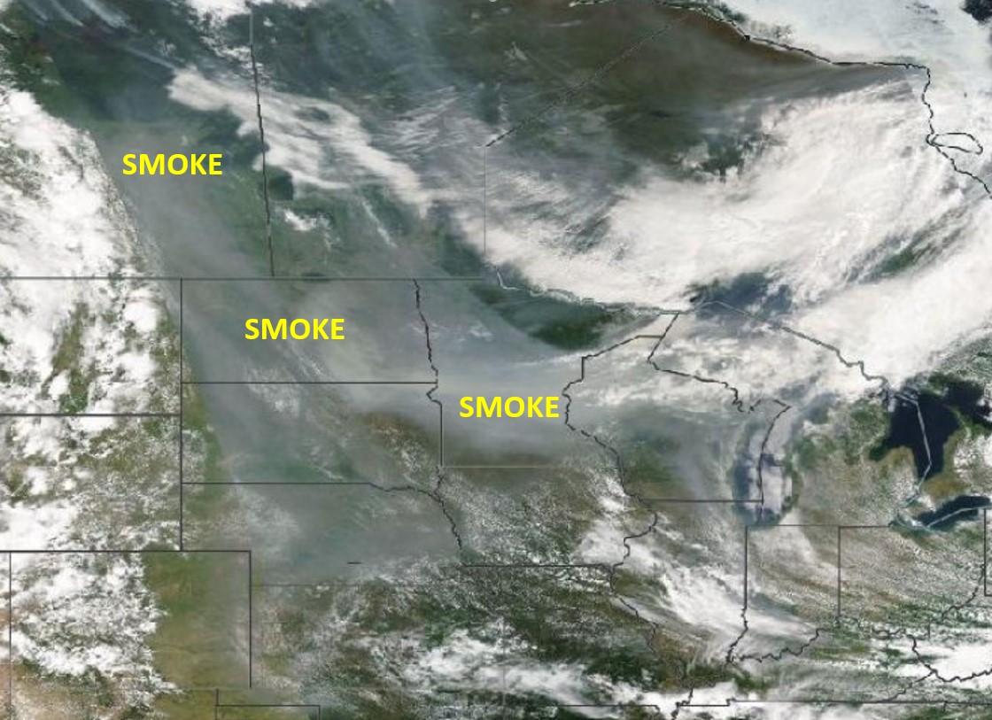
JUNE 18 VISIBLE SATELLITE IMAGERY
JUNE 27 SMOKE AT NWS LINCOLN
 |
 |
=============================================================================================================================
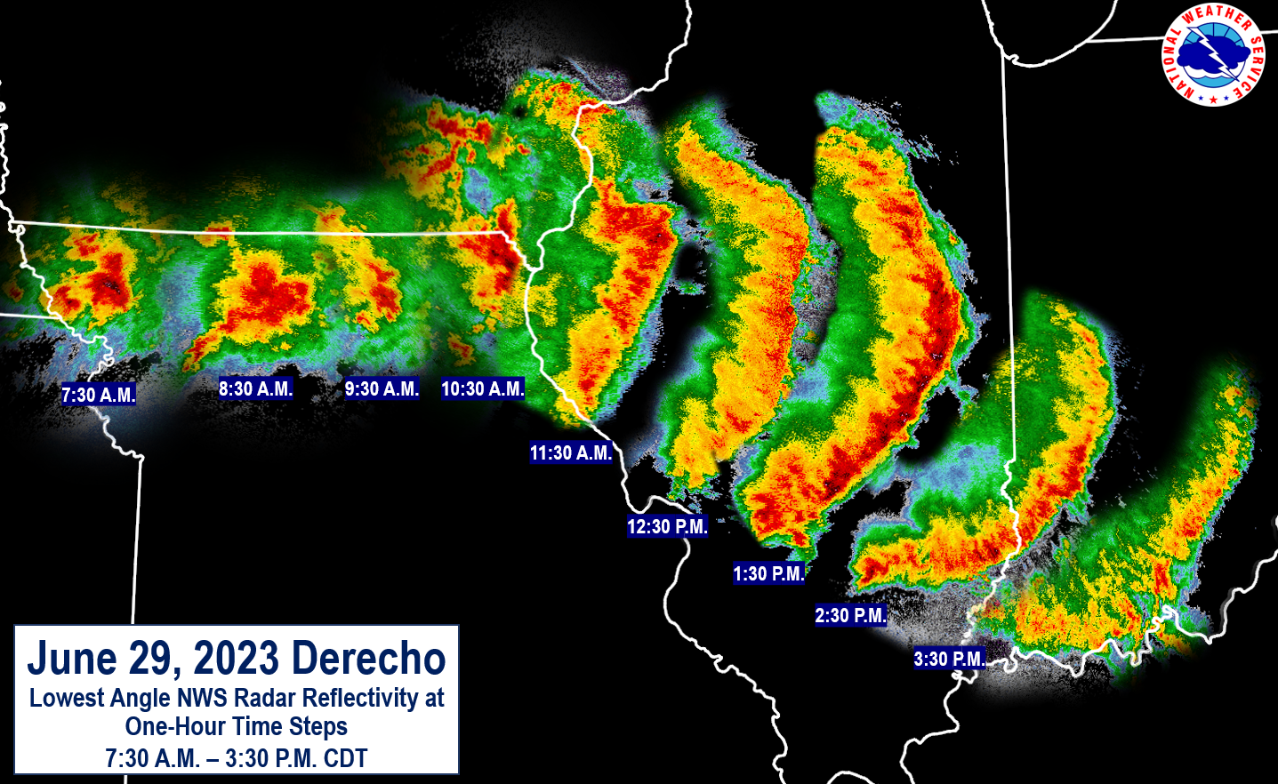
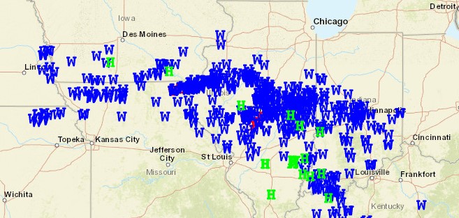
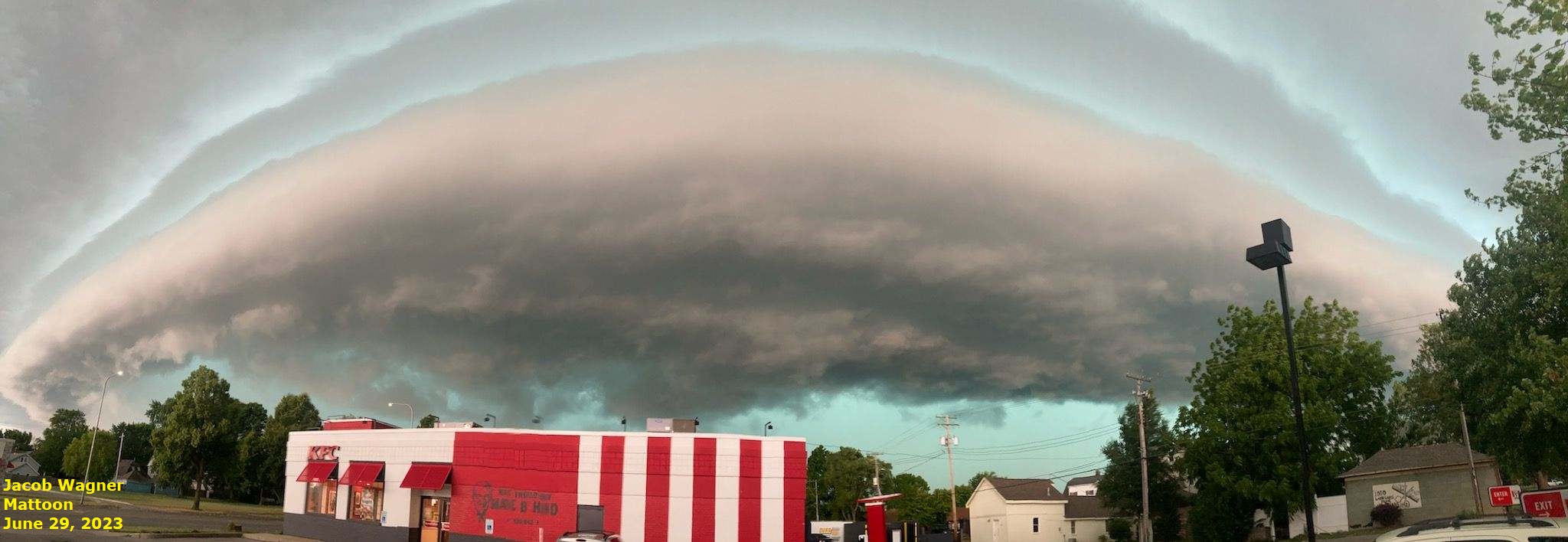
7) June 29: Derecho
A cluster of thunderstorms that initiated during the night of June 28th across the Central Plains entered west-central Illinois by the late morning of June 29th. Aided by an increasingly unstable airmass characterized by CAPE values of 3000-4000J/kg and a 30-40kt mid-level jet streak, the storms became linear in nature and began racing east-southeastward across central Illinois. Widespread wind gusts of 60-80 mph were observed along the line, with localized corridors of even higher gusts. The highest measured gust of 101 mph came from a personal weather station near Taylorville that took a direct hit from a tornado. A total of seven tornadoes were embedded within the line of storms, including an EF-2 tornado near Curran in Sangamon County. The high winds caused extensive tree and power line damage, leading to power loss for over 200,000 customers. Some people in the Springfield area were without power for nearly a week before all lines were restored. The winds impacted all of central and southeast Illinois, but were most concentrated between the I-74 and I-70 corridors. Once the line of storms dropped into the Ohio River Valley, additional severe cells fired along the trailing outflow boundary south of I-70 during the late afternoon. These storms produced hail as large as 2 inches in diameter across parts of Clay, Richland, and Lawrence counties.
A derecho is defined as a widespread and long-lived damaging wind event. Specifically: consistent wind damage must be observed in a swath for greater than 240 miles and wind gusts must equal or exceed 58 mph along most of the path. Below is hourly radar imagery from the June 29th derecho. Note how the system tracked E/SE across central Illinois before curving more to the SE and weakening as it approached the Ohio River.
JUNE 29 SEVERE WEATHER REPORTS
APPROACHING SHELF CLOUD IN MATTOON
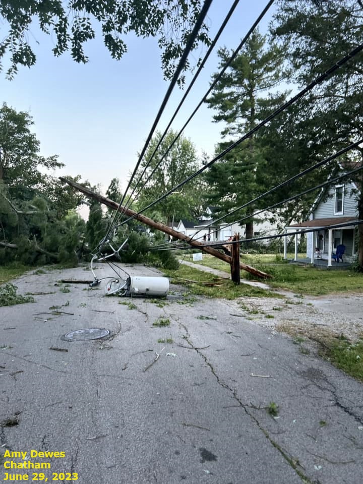
WIND DAMAGE IN CHATHAM
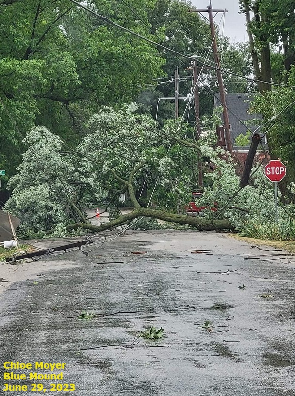
WIND DAMAGE IN BLUE MOUND
=============================================================================================================================
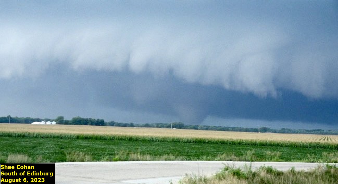
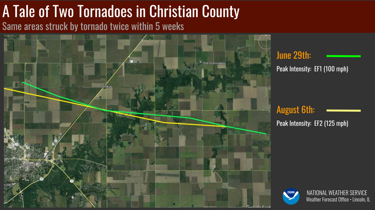
8) August 6: Long-Track Tornado in Sangamon and Christian Counties
A vigorous short-wave trough interacted with an approaching low pressure system and associated warm frontal boundary to trigger clusters of strong to severe thunderstorms across west-central Illinois during the late afternoon of August 6th. Due to enhanced low-level wind shear along and north of the warm front, many of the cells began rotating and spinning up occasional funnel clouds. One of the cells intensified as it pushed into Sangamon County, producing a long-track tornado that was on the ground for over 25 miles from just north of Pawnee in far southeastern Sangamon County to southeast of Stonington in Christian County. The tornado produced EF-1 damage along much of its path, peaking with EF-2 damage just south of Willeys in Christian County. This particular thunderstorm cell dropped 2-inch diameter hail north of Taylorville and went on to produce a downburst with 80 mph wind gusts in far eastern Shelby County near Lake Mattoon. The storms eventually congealed into a line as they pushed into eastern Illinois later in the evening, with scattered wind damage, hail, and flash flooding.
AUGUST 6, 2023 TORNADO TRACK
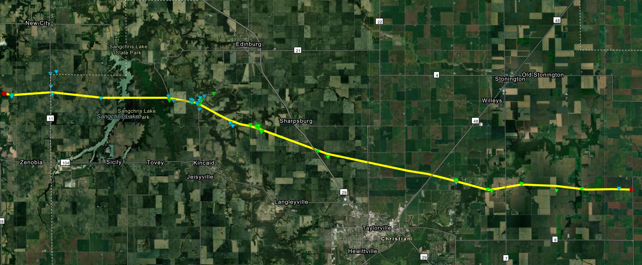
The track of the August 6, 2023 tornado was very close to the track of the June 29, 2023 tornado. In fact, the paths actually crossed at a couple points...meaning those spots got hit by two different tornadoes only 5 weeks apart!
=============================================================================================================================
9) Numerous Very Large Hail Events
In any given year, it's quite common to see hailstones as large as golf balls (1.75" in diameter) across central Illinois: however, hail exceeding 2" in diameter is not a yearly occurrence. 2023 turned out to be an atypical year, as there were 22 reports of hail 2'' in diameter or larger occurring on 10 separate days. The largest stone fell in the town of Bernadotte in Fulton County on April 4th and measured a whopping 4" in diameter, which is roughly the size of a softball! Even though that's certainly a giant stone, the National Weather Service Lincoln County Warning Area (CWA) has actually seen hail up to 4.5" in diameter on 5 past occasions with the most recent being in rural McLean County near Stanford on May 9th, 2003.
The all-time record for the state of Illinois is the 4.75" diameter hailstone that fell north of Minooka on June 10, 2015: Illinois Record.
2023 Large Hail Reports (2" or greater in diameter)
| DATE | DIAMETER | CITY | COUNTY |
| March 31 | 2.75" | Banner | Fulton |
| March 31 | 2.50" | Roanoke | Woodford |
| March 31 | 2.00" | Roanoke 1WSW | Woodford |
| April 4 | 4.00" | Bernadotte | Fulton |
| April 4 | 3.25" | Table Grove 1WSW | Fulton |
| April 4 | 2.75" | Table Grove | Fulton |
| April 4 | 2.75" | Vermont | Fulton |
| April 19 | 2.00" | Leroy 1ESE | McLean |
| April 20 | 2.00" | Germantown Hills | Woodford |
| May 7 | 3.25" | Chatham | Sangamon |
| May 7 | 2.50" | Morrisonville 5SE | Christian |
| May 7 | 2.00" | Chatham | Sangamon |
| May 7 | 2.00" | Auburn | Sangamon |
| May 7 | 2.00" | Divernon | Sangamon |
| May 7 | 2.00" | Chatham | Sangamon |
| June 29 | 3.25" | Tuscola 1N | Douglas |
| June 29 | 2.00" | Noble 5SE | Richland |
| July 17 | 2.00" | Newell 2NW | Vermilion |
| July 23 | 2.00" | Chatham | Sangamon |
| July 23 | 2.50" | Chatham | Sangamon |
| July 25 | 2.50" | Arthur 1ENE | Douglas |
| August 6 | 2.00" | Taylorville 7N | Christian |
=============================================================================================================================
10) 39 Tornadoes Across Central Illinois in 2023
A typical year sees 20-25 tornado touchdowns within the NWS Lincoln County Warning Area (CWA).
Winter (10)
| DATE | COUNTY | BEGIN LOCATION | EF-SCALE |
| January 3 | Sangamon | 2.7 miles northwest of Illiopolis | EF-U |
| January 3 | Logan | 2.6 miles southwest of Latham | EF-U |
| January 3 | Macon | 3.5 miles southwest of Maroa | EF-0 |
| January 3 | Macon | Northwest edge of Maroa | EF-1 |
| January 3 | Christian | 3.7 miles east-northeast of Mount Auburn | EF-U |
| January 3 | McLean | 2.8 miles southeast of Bellflower | EF-1 |
| January 3 | Macon | Northeast side of Decatur | EF-1 |
| January 3 | Macon | Northeast Decatur | EF-0 |
| February 27 | Champaign | 1 mile south-southeast of Bondville | EF-0 |
| February 27 | Champaign | 3.3 miles northwest of Champaign | EF-U |
Spring (18)
| DATE | COUNTY | BEGIN LOCATION | EF-SCALE |
| March 31 | Christian | 2 miles south of Taylorville | EF-1 |
| March 31 | Tazewell | 3.5 miles southeast of Banner | EF-U |
| March 31 | Tazewell | 1 mile northwest of Deer Creek | EF-1 |
| March 31 | Woodford | 3 miles east of Eureka | EF-U |
| March 31 | Scott | 6.5 miles west-northwest of Winchester | EF-U |
| March 31 | Morgan | 2.8 miles east of Chapin | EF-U |
| March 31 | Morgan | 2.4 miles north of the Jacksonville Airport | EF-0 |
| March 31 | Sangamon | Sherman | EF-2 |
| March 31 | Sangamon/Logan | Riverton | EF-2 |
| March 31 | Christian | 4.4 miles northwest of Morrisonville | EF-0 |
| March 31 | Champaign | 2.6 miles south of Dewey | EF-1 |
| March 31 | Vermilion | 4.4 miles south-southwest of Rankin | EF-1 |
| March 31 | Jasper/Crawford | 2.9 miles southwest of Saint Marie | EF-3 |
| April 4 | Fulton | Table Grove | EF-1 |
| April 4 | Fulton | 2.5 miles west of Ipava | EF-U |
| April 4 | Fulton | 1 mile south of Ipava | EF-3 |
| April 4 | Fulton | 4.2 miles east of Lewistown | EF-U |
| May 13 | Macon | 1 mile northwest of Boody | EF-U |
Summer (11)
| DATE | COUNTY | BEGIN LOCATION | EF-SCALE |
| June 29 | Sangamon | 4 miles southwest of Springfield | EF-2 |
| June 29 | Logan | Lincoln | EF-1 |
| June 29 | Christian | 5 miles south-southwest of Tovey | EF-U |
| June 29 | Christian | 1 mile north of Kincaid | EF-1 |
| June 29 | Christian | 1 mile south of Mount Auburn | EF-1 |
| June 29 | Logan/DeWitt | 3 miles southwest of Waynesville | EF-1 |
| June 29 | Christian | 3 miles north of Taylorville | EF-1 |
| August 6 | Sangamon/Christian | 3 miles north of Pawnee | EF-2 |
| August 25 | Jasper | 3 miles northeast of Willow Hill | EF-U |
| August 26 | Fulton | 2 miles south of Marietta | EF-U |
| August 26 | Fulton | 1 mile south-southwest of Marietta | EF-U |
Fall (0)
=============================================================================================================================

