Latest aviation discussion:
.AVIATION /00Z THURSDAY THROUGH MONDAY/...

Variable conditions around the area early this evening. However,
rain will continue to overspread much of the area through the
late evening and overnight hours, lowering CIGs to widespread
IFR at most TAF sites. RME and SYR will be on the edge of the
steadier rain, so may fluctuate between IFR/MVFR through most
of the TAF period. Highest confidence is persistent IFR to LIFR
conditions overnight into Thursday morning will be at ITH, BGM
and ELM...with AVP also potentially seeing IFR conditions
heading into Thursday morning and early afternoon. Overall,
expect dreary, rainy conditions with some patchy fog around at
times. Latest model guidance does not show much if any
improvement heading into Thursday afternoon, and keeps most of
the area IFR right through the end of the TAF period (again,
except borderline low end MVFR at SYR and RME).

Light and variable winds under 10 kts expected tonight into
Thursday morning. Winds then turn southeast at 8-15 kts Thursday
afternoon and early evening.

Outlook:

Thursday Night: Lingering IFR or lower CIGs likely for at least
a portion of the area. Isolated pockets of fog also possible.

Friday through Saturday...Isolated to scattered rain
showers and a low chance for afternoon thunderstorms; associated
occasional restrictions possible.

Sunday...A frontal system approaches the region with additional
showers and restrictions possible.

Monday...VFR conditions possible as high pressure builds.
|
This discussion and more can be found in the Area Forecast Discussion.
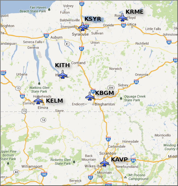
Aviation Forecasts
The National Weather Service Office in Binghamton, NY has responsibility for six Terminal Aerodrome Forecasts or TAFs in Central New York and Northeast Pennsylvania.
Click on a site on the map below to view the latest TAF.
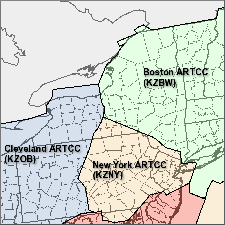
Center Weather Service Unit Products
Three Center Weather Service Unit (CWSU) cover the NWS Binghamton, NY County Warning Area. Click on the map or one of the links below the map to go to the corresponding CSWU website.
Text links...
Decoded/Raw Text
| Location | Sky/Weather | Temperature | Dewpoint Temperature | Relative Humidity | Wind | Pressure | Remarks |
| Binghamton, NY | LGT RAIN | 37 | 36 | 96 | NE10 | 30.25S | WCI 30 |
| Cortland, NY | RAIN | 36 | 36 | 100 | NE6 | 30.30F | WCI 31 |
| Dansville, NY | LGT RAIN | 39 | 37 | 92 | N3 | 30.31S | |
| Elmira, NY | LGT RAIN | 38 | 35 | 89 | NE3 | 30.29F | FOG |
| Ithaca, NY | LGT RAIN | 37 | 36 | 96 | N3 | 30.30F | |
| Monticello, NY | LGT RAIN | 45 | 44 | 97 | E12 | 30.22F | |
| Penn Yan, NY | LGT RAIN | 36 | 34 | 92 | NE7 | 30.31F | WCI 30 |
| Rome, NY | CLOUDY | 39 | 32 | 76 | CALM | 30.35R | |
| Syracuse, NY | CLOUDY | 39 | 33 | 79 | NE5 | 30.35R | |
| Hazleton, PA | LGT RAIN | 45 | 41 | 87 | N6 | 30.24R | |
| Scranton, PA | CLOUDY | 46 | 41 | 82 | N12 | 30.23R | |
METAR Request form via the Aviation Weather Center. Raw and decoded observations.
​Surface Weather Maps
Miscellaneous

