Latest aviation discussion:
.AVIATION /06Z MONDAY THROUGH FRIDAY/...
VFR conditions across the region as high pressure is in place,
with these conditions lasting through the TAF period for much of
the region.

Some high level cirrus clouds are streaming overhead, which
will limit some cooling over the next few hours, but they should
clear out and allow valley fog to develop just before sunrise.
ELM should see some periods of IFR and lower restrictions due to
the fog. Confidence in it developing is only moderate given the
very dry airmass in place but with current temps and dewpoints
near the crossover thresholds now, thinking is that we will see
enough cooling after the cirrus clouds pass to generate a short
period of fog around ELM. ITH also has a chance for some fog
this morning, but with winds remaining active, we should only
see a few instances of MVFR restrictions later this morning if
we can get some periods of calm winds.


Outlook:

Monday night...Mainly VFR; a low chance of showers spreading up
from the south late.

Tuesday and Wednesday...A chance of showers and thunderstorms
along with associated restrictions.

Thursday and Friday... Mainly VFR.
|
This discussion and more can be found in the Area Forecast Discussion.
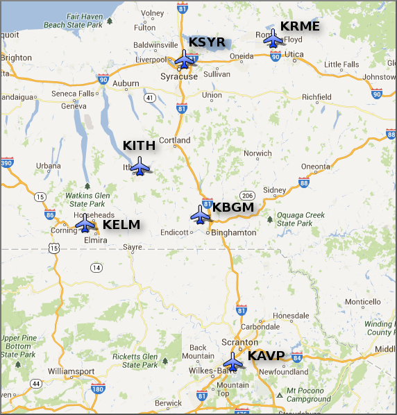
Aviation Forecasts
The National Weather Service Office in Binghamton, NY has responsibility for six Terminal Aerodrome Forecasts or TAFs in Central New York and Northeast Pennsylvania.
Click on a site on the map below to view the latest TAF.
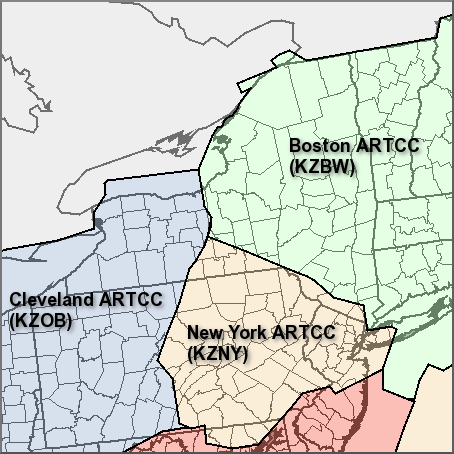
Center Weather Service Unit Products
Three Center Weather Service Unit (CWSU) cover the NWS Binghamton, NY County Warning Area. Click on the map or one of the links below the map to go to the corresponding CSWU website.
Text links...
Decoded/Raw Text
| Location | Sky/Weather | Temperature | Dewpoint Temperature | Relative Humidity | Wind | Pressure | Remarks |
| Binghamton, NY | CLEAR | 56 | 47 | 71 | W3 | 30.01S | |
| Cortland, NY | CLEAR | 46 | 46 | 100 | CALM | 30.01F | |
| Dansville, NY | PTCLDY | 54 | 51 | 90 | SE7 | 30.02F | |
| Elmira, NY | PTCLDY | 49 | 49 | 100 | CALM | 30.00F | |
| Ithaca, NY | CLEAR | 51 | 49 | 92 | E6 | 30.01 | |
| Monticello, NY | CLEAR | 51 | 48 | 89 | CALM | 30.00F | |
| Penn Yan, NY | PTCLDY | 57 | 54 | 89 | SW5 | 30.00F | |
| Rome, NY | PTCLDY | 54 | 51 | 90 | CALM | 30.00F | |
| Syracuse, NY | PTCLDY | 58 | 48 | 69 | SE3 | 29.97F | |
| Hazleton, PA | CLEAR | 50 | 46 | 87 | CALM | 30.04F | |
| Scranton, PA | CLEAR | 55 | 49 | 80 | E8 | 30.00F | |
| 200 AM EDT MON JUL 20 2026 | |||||||
METAR Request form via the Aviation Weather Center. Raw and decoded observations.
​Surface Weather Maps
Miscellaneous

