A hourly weather graph forecast can be generated by going to the Hourly Graph website.
Guide to decoding the forecast below.
189
FNUS81 KBGM 141502
FWMBGM
FCST,301011,250815,13,1,84,44,,,E,03,,86,58,96,43,0,0,N
FCST,301011,250816,13,1,85,48,,,SSW,04,,87,64,97,41,0,0,N
FCST,301011,250817,13,2,83,56,,,WNW,05,,89,65,93,44,0,0,N
FCST,301011,250818,13,1,77,50,,,N,05,,84,59,90,49,0,0,N
FCST,301011,250819,13,2,76,61,,,S,05,,80,57,96,45,0,0,N
FCST,301011,250820,13,2,73,64,,,W,06,,79,60,100,56,0,0,N
FCST,301011,250821,13,1,76,52,,,NW,05,,78,57,95,50,0,0,N
FCST,300171,250815,13,1,81,46,,,ENE,04,,83,58,96,44,0,0,N
FCST,300171,250816,13,1,82,54,,,SW,05,,85,63,97,41,0,0,N
FCST,300171,250817,13,2,81,56,,,W,06,,86,64,97,49,0,0,N
FCST,300171,250818,13,1,75,51,,,N,05,,82,58,93,50,0,0,N
FCST,300171,250819,13,2,73,61,,,S,05,,78,56,87,46,0,0,N
FCST,300171,250820,13,2,72,64,,,SSW,06,,75,58,100,57,0,0,N
FCST,300171,250821,13,1,75,52,,,NW,06,,76,56,94,50,0,0,N
FCST,361802,250815,13,1,84,59,,,E,02,,86,64,97,55,0,0,N
FCST,361802,250816,13,1,84,59,,,S,02,,86,65,100,55,0,0,N
FCST,361802,250817,13,2,87,56,,,WSW,04,,88,64,100,54,0,0,N
FCST,361802,250818,13,2,79,61,,,ENE,03,,88,64,97,54,0,0,N
FCST,361802,250819,13,2,76,65,,,SSE,03,,80,61,100,56,0,0,N
FCST,361802,250820,13,2,76,66,,,ENE,04,,79,60,100,60,0,0,N
FCST,361802,250821,13,1,78,53,,,N,04,,79,57,100,52,0,0,N
FCST,360791,250815,13,1,79,62,,,E,03,,81,61,97,58,0,0,N
FCST,360791,250816,13,1,78,67,,,S,04,,81,63,100,58,0,0,N
FCST,360791,250817,13,2,80,64,,,W,05,,82,63,100,61,0,0,N
FCST,360791,250818,13,2,75,64,,,N,05,,82,62,97,61,0,0,N
FCST,360791,250819,13,2,72,72,,,SSE,05,,76,59,97,62,0,0,N
FCST,360791,250820,13,2,71,73,,,SSE,06,,74,58,100,66,0,0,N
FCST,360791,250821,13,1,73,58,,,NNW,06,,75,55,96,56,0,0,N
FCST,360792,250815,13,1,84,58,,,ENE,02,,87,63,97,53,0,0,N
FCST,360792,250816,13,1,83,61,,,SSW,02,,88,64,100,52,0,0,N
FCST,360792,250817,13,2,83,63,,,W,04,,87,65,97,53,0,0,N
FCST,360792,250818,13,1,79,60,,,N,03,,87,63,97,56,0,0,N
FCST,360792,250819,13,2,76,68,,,S,04,,83,62,93,53,0,0,N
FCST,360792,250820,13,2,74,71,,,S,04,,81,60,97,58,0,0,N
FCST,360792,250821,13,1,77,56,,,NW,04,,80,58,94,52,0,0,N
FCST,360151,250815,13,1,84,55,,,ENE,02,,85,61,100,53,0,0,N
FCST,360151,250816,13,1,83,62,,,SSW,03,,86,65,100,51,0,0,N
FCST,360151,250817,13,2,84,61,,,W,04,,85,66,100,55,0,0,N
FCST,360151,250818,13,1,78,58,,,N,04,,85,62,97,56,0,0,N
FCST,360151,250819,13,2,76,68,,,S,04,,80,60,97,54,0,0,N
FCST,360151,250820,13,2,73,73,,,S,05,,78,60,100,62,0,0,N
FCST,360151,250821,13,1,76,58,,,NW,05,,77,58,100,58,0,0,N
FCST,361031,250815,13,1,82,63,,,E,03,,83,63,97,61,0,0,N
FCST,361031,250816,13,1,81,65,,,S,03,,84,64,100,59,0,0,N
FCST,361031,250817,13,2,84,61,,,WSW,05,,85,63,100,59,0,0,N
FCST,361031,250818,13,2,78,65,,,NE,04,,86,63,100,57,0,0,N
FCST,361031,250819,13,2,75,69,,,SSE,04,,79,59,100,62,0,0,N
FCST,361031,250820,13,2,74,70,,,E,05,,77,58,100,62,0,0,N
FCST,361031,250821,13,1,76,57,,,N,05,,77,56,100,56,0,0,N
FCST,300971,250815,13,1,81,49,,,ENE,05,,82,59,93,49,0,0,N
FCST,300971,250816,13,1,84,53,,,SW,05,,84,65,87,46,0,0,N
FCST,300971,250817,13,2,80,61,,,WNW,09,,85,67,87,49,0,0,N
FCST,300971,250818,13,1,74,56,,,N,09,,81,60,90,55,0,0,N
FCST,300971,250819,13,2,74,67,,,S,08,,76,59,87,52,0,0,N
FCST,300971,250820,13,2,72,69,,,WNW,09,,75,62,93,64,0,0,N
FCST,300971,250821,13,1,73,58,,,NW,09,,75,58,90,57,0,0,N
830
FNUS51 KBGM 141501
FWFBGM
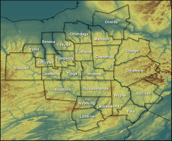
Fire Weather Planning Forecast for Central NY/Northeast PA
National Weather Service Binghamton NY
1100 AM EDT Thu Aug 14 2025
.SYNOPSIS... Isolated showers and thunderstorms will be possible
today in the Poconos and southern Catskills. Quieter conditions
and warmer temperatures return at the end of the week and into
the start of the weekend. A frontal system will move through on
Sunday with rain and cooler temperatures.
NYZ210-142000-
Leatherstocking-
1100 AM EDT Thu Aug 14 2025
Today Tonight Fri
Cloud Cover Pcldy Mclear Mclear
Precip Type Showers None None
Chance Precip (%) 20 0 0
Chance of Thunder (%) 0 0 0
Temp (24h trend) 84 (0) 57 (-7) 86
RH % (24h trend) 41 (-9) 100 (0) 35
Wind 20ft/early(mph) Lgt/Var Lgt/Var Lgt/Var
Wind 20ft/late(mph) N 3-7 Lgt/Var Lgt/Var
Precip Amount 0.00 0.00 0.00
Precip Duration 1
Precip Begin 9 AM
Precip End 6 PM
Mixing Hgt(ft-agl/msl)5940 6120
Transport Wnd (mph) N 10 SW 5
Vent Rate (kt-ft) 63250 37560
DSI 2 2 2
Sunshine Hours 9 13
ADI early 22 Fair 42 Gen Good 16 Gen Poor
ADI late 67 Good 4 Very Poor 32 Fair
Max LVORI early 9 5 6
Max LVORI late 3 6 2
Remarks: ADI is Atmospheric Dispersion Index by Lavdas.
LVORI is Low Visibility Occurrence Risk Index.
.FORECAST FOR DAYS 3 THROUGH 7...
.SATURDAY...Mostly clear. A slight chance of showers and
thunderstorms. Lows in the lower 60s. Highs in the mid 80s.
Southeast winds around 5 mph.
.SUNDAY...Partly cloudy. A 50 percent chance of showers and
thunderstorms. Lows in the mid 60s. Highs in the mid 80s. South
winds around 5 mph.
.MONDAY...Partly cloudy. A slight chance of showers and
thunderstorms. Lows in the upper 50s. Highs in the upper 70s.
North winds around 5 mph.
.TUESDAY...Partly cloudy. A chance of showers and a slight chance
of thunderstorms. Lows in the mid 50s. Highs in the mid 70s.
Chance of precipitation 40 percent. East winds around 5 mph.
.WEDNESDAY...Mostly cloudy. A 40 percent chance of showers and
thunderstorms. Lows in the upper 50s. Highs in the mid 70s. East
winds around 5 mph.
$$
PAZ038-039-043-142000-
Bradford-Susquehanna-Wyoming-
Including the cities of Sayre, Towanda, Hallstead, Montrose,
and Tunkhannock
1100 AM EDT Thu Aug 14 2025
Today Tonight Fri
Cloud Cover Pcldy Mclear Mclear
Precip Type Tstms None None
Chance Precip (%) 20 0 0
Chance of Thunder (%) 20 0 0
Temp (24h trend) 85 (+1) 58 (-7) 86
RH % (24h trend) 52 (-11) 100 (0) 43
Wind 20ft/early(mph) Lgt/Var Lgt/Var Lgt/Var
Wind 20ft/late(mph) N 3-7 Lgt/Var Lgt/Var
Precip Amount 0.00 0.00 0.00
Precip Duration 1
Precip Begin 9 AM
Precip End 6 PM
Mixing Hgt(ft-agl/msl)6200 6070
Transport Wnd (mph) N 9 S 5
Vent Rate (kt-ft) 56480 35120
DSI 2 2 2
Sunshine Hours 8 12
ADI early 28 Fair 39 Fair 19 Gen Poor
ADI late 66 Good 4 Very Poor 33 Fair
Max LVORI early 9 5 7
Max LVORI late 3 7 2
Remarks: ADI is Atmospheric Dispersion Index by Lavdas.
LVORI is Low Visibility Occurrence Risk Index.
.FORECAST FOR DAYS 3 THROUGH 7...
.SATURDAY...Partly cloudy. A slight chance of showers and
thunderstorms. Lows in the mid 60s. Highs in the mid 80s.
Southeast winds around 5 mph.
.SUNDAY...Partly cloudy. A 40 percent chance of showers and
thunderstorms. Lows in the mid 60s. Highs in the mid 80s. South
winds around 5 mph.
.MONDAY...Partly cloudy. A slight chance of showers and
thunderstorms. Lows in the lower 60s. Highs in the lower 80s.
North winds around 5 mph.
.TUESDAY...Partly cloudy. A chance of showers and a slight chance
of thunderstorms. Lows in the upper 50s. Highs in the upper 70s.
Chance of precipitation 40 percent. Southeast winds around 5 mph.
.WEDNESDAY...Mostly cloudy. A 40 percent chance of showers and
thunderstorms. Lows around 60. Highs in the mid 70s. South winds
around 5 mph.
$$
PAZ044-047-142000-
Lackawanna-Luzerne-
Including the cities of Scranton, Hazleton, and Wilkes-Barre
1100 AM EDT Thu Aug 14 2025
Today Tonight Fri
Cloud Cover Pcldy Mclear Mclear
Precip Type Tstms None Showers
Chance Precip (%) 30 0 20
Chance of Thunder (%) 30 0 0
Temp (24h trend) 87 (+2) 61 (-5) 87
RH % (24h trend) 55 (-4) 100 (0) 48
Wind 20ft/early(mph) Lgt/Var Lgt/Var Lgt/Var
Wind 20ft/late(mph) Lgt/Var Lgt/Var Lgt/Var
Precip Amount 0.01 0.00 0.01
Precip Duration 2 0
Precip Begin 6 AM 2 PM
Precip End 6 PM 6 PM
Mixing Hgt(ft-agl/msl)5650 5460
Transport Wnd (mph) N 8 SE 5
Vent Rate (kt-ft) 50830 29290
DSI 2 2 2
Sunshine Hours 7 11
ADI early 28 Fair 27 Fair 23 Fair
ADI late 49 Gen Good 4 Very Poor 31 Fair
Max LVORI early 9 6 7
Max LVORI late 3 7 3
Remarks: ADI is Atmospheric Dispersion Index by Lavdas.
LVORI is Low Visibility Occurrence Risk Index.
.FORECAST FOR DAYS 3 THROUGH 7...
.SATURDAY...Partly cloudy. A slight chance of showers and
thunderstorms. Lows in the mid 60s. Highs in the mid 80s. Light
winds.
.SUNDAY...Mostly clear. A 40 percent chance of showers and
thunderstorms. Lows in the mid 60s. Highs in the mid 80s. South
winds around 5 mph.
.MONDAY...Partly cloudy. A slight chance of showers and
thunderstorms. Lows in the lower 60s. Highs in the lower 80s.
North winds around 5 mph.
.TUESDAY...Mostly cloudy. A chance of showers and a slight chance
of thunderstorms. Lows in the lower 60s. Highs in the upper 70s.
Chance of precipitation 40 percent. East winds around 5 mph.
.WEDNESDAY...Mostly cloudy. A chance of showers and a slight
chance of thunderstorms. Lows around 60. Highs in the upper 70s.
Chance of precipitation 40 percent. Southeast winds around 5 mph.
$$
PAZ040-048-072-142000-
Northern Wayne-Pike-Southern Wayne-
Including the cities of Damascus, Equinunk, Milford,
and Honesdale
1100 AM EDT Thu Aug 14 2025
Today Tonight Fri
Cloud Cover Pcldy Mclear Mclear
Precip Type Tstms None None
Chance Precip (%) 40 0 0
Chance of Thunder (%) 40 0 0
Temp (24h trend) 85 (0) 60 (-6) 85
RH % (24h trend) 55 (-4) 100 (0) 48
Wind 20ft/early(mph) Lgt/Var Lgt/Var Lgt/Var
Wind 20ft/late(mph) Lgt/Var Lgt/Var Lgt/Var
Precip Amount 0.02 0.00 0.00
Precip Duration 2
Precip Begin 6 AM
Precip End 6 PM
Mixing Hgt(ft-agl/msl)6030 5530
Transport Wnd (mph) N 9 SE 5
Vent Rate (kt-ft) 55950 25070
DSI 2 2 2
Sunshine Hours 7 11
ADI early 31 Fair 36 Fair 25 Fair
ADI late 60 Gen Good 4 Very Poor 30 Fair
Max LVORI early 9 7 7
Max LVORI late 3 7 2
Remarks: ADI is Atmospheric Dispersion Index by Lavdas.
LVORI is Low Visibility Occurrence Risk Index.
.FORECAST FOR DAYS 3 THROUGH 7...
.SATURDAY...Partly cloudy. A slight chance of showers and
thunderstorms. Lows in the lower 60s. Highs in the mid 80s. Light
winds.
.SUNDAY...Mostly clear. A 40 percent chance of showers and
thunderstorms. Lows in the mid 60s. Highs in the mid 80s.
Southwest winds around 5 mph.
.MONDAY...Partly cloudy. A slight chance of showers and
thunderstorms. Lows in the lower 60s. Highs around 80. North
winds around 5 mph.
.TUESDAY...Mostly cloudy. A chance of showers and a slight chance
of thunderstorms. Lows in the upper 50s. Highs in the upper 70s.
Chance of precipitation 30 percent. Southeast winds around 5 mph.
.WEDNESDAY...Mostly cloudy. A chance of showers and a slight
chance of thunderstorms. Lows in the upper 50s. Highs in the mid
70s. Chance of precipitation 40 percent. Southeast winds around
5 mph.
$$